Update to NOAA Global Temperature dataset improves data coverage of Earth

As monitoring of land and ocean surface temperature becomes even more critical, NOAA announces the additional update of a dataset that capitalizes on increasing sophistication in monitoring global temperatures.
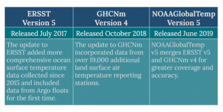
The latest version of NOAA Merged Land-Ocean Global Surface Temperature Analysis Dataset, commonly known as NOAAGlobalTemp, builds on recent improvements to two existing NCEI datasets. Updates of the Global Historical Climatology Network–Monthly (GHCNm) and Extended Reconstructed Sea Surface Temperature (ERSST) datasets preceded the release of the newest NOAAGlobalTemp. GHCNm version 4 and ERSST version 5 merge to form NOAAGlobalTemp version 5.
NOAAGlobalTemp Version 5
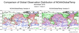
The merged product uses more comprehensive data collections that increase global area coverage over both land and ocean surfaces and incorporates refinements that reduce uncertainty caused by historical changes in observations.
Both supporting datasets provide distinctive components to NOAAGlobalTemp:
-
ERSST includes ocean surface temperature data from several sources, including comprehensive arrays of Argo floats, surface drifters, moored buoys, and ships positioned and sailing around the world.
-
GHCNm is a large set of monthly mean surface air temperature data gathered over global land areas.
The new merged dataset spans each month from 1880 to present.
History and Uses of NOAAGlobalTemp
NOAAGlobalTemp supports the assessments of global climate conditions that help decision makers and private enterprise. As a matter of course, NOAA and other research institutions around the world analyze historical temperature records for the most-accurate understanding of global conditions. The goal continues to be to provide the best scientific representation of the long-term record for informed decisions.
Researchers from NOAA, NASA, and select international groups (such as UK MetOffice) who develop standardized datasets of global temperatures continually consider improvements. Changes and advancements in temperature observation methods, such as from ships or land-based weather stations, and the varied lengths of the historical records can lead to challenges. Because of the diverse data collection, issues of data uniformity arise. For instance, records of ocean temperatures from the 19th century are based on collections from buckets, a method that has virtually been phased out today.
NCEI applies NOAAGlobalTemp to operational climate-monitoring activities, such as the monthly Global Climate Report. The report, along with maps and graphs, is written each month and annually by scientists studying climate trends. Models are also developed using the dataset. The major consumers and users of the report and the dataset include atmospheric and oceanographic scientists and industry-specific researchers in many sectors such as energy, defense, insurance, aquaculture, and agriculture.
Reference: Zhang, Huai-Min, Jay H. Lawrimore, Boyin Huang, Matthew J. Menne, Xungang Yin, Ahira Sȧnchez-Lugo, Byron E. Gleason, Russell Vose, Derek Arndt, J. Jared Rennie, and Claude N. Williams. (2019) "Updated Temperature Data Give a Sharper View of Climate Trends." Eos, 100, https://doi.org/10.1029/2019EO128229. Published on 19 July 2019.


