
Second warmest summer for Alaska, 13th warmest August for U.S.

For August, the contiguous U.S. average temperature was 73.9°F, 1.8°F above the 20th century average and tied with 1955 as the 13th warmest August on record. During meteorological summer (June–August), the average temperature for the Lower 48 was 72.4°F, 1.0°F above average, ranking in the upper third of the historical record. For the year to date, the contiguous U.S. temperature was 54.3°F, 0.4°F above the 20th century average, ranking in the middle third of the January–August record.
The August precipitation total for the contiguous U.S. was 2.74 inches, 0.12 inch above average, ranking in the middle third of the 125-year period of record. The summer precipitation total across the Lower 48 was 8.83 inches, 0.51 inch above average, ranking in the upper third of the historical record due to a wet June. The year-to-date precipitation total across the contiguous U.S. was 24.59 inches, 3.88 inches above the long-term average, ranking as the wettest January–August on record. Five of the first six months of 2019 were wet, contributing to the record wet accumulation for January–August. Average precipitation across the contiguous U.S. for the 12-month period September 2018–August 2019 was 37.55 inches, 7.61 inches above average, exceeding the previous September–August record set in 1972-73 by more than three inches. The September 2018–August 2019 period also ranks as the fourth wettest among all 12-month periods on record.

This monthly summary from NOAA National Centers for Environmental Information is part of the suite of climate services NOAA provides to government, business, academia, and the public to support informed decision-making.
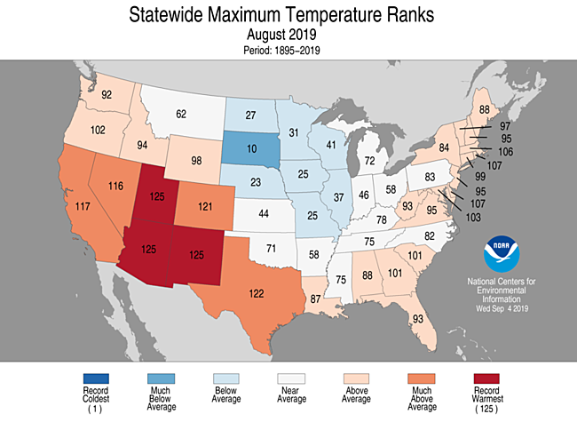
August Temperature

- Above- to much-above-average August temperatures were observed from the West Coast to the Deep South and from Florida to Maine. Arizona, New Mexico, and Texas each had their second warmest August on record, while Utah had its fourth warmest. The predominance of warmth across the West and Southwest can be attributed to record and near-record warm daytime high temperatures.
-
Near-to- and below-average temperatures were present across much of the central and northern Plains as well as across the Great Lakes.
-
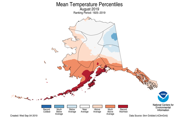
The Alaska average August temperature was 51.6°F, 2.1°F above the long-term mean, ranking in the upper third of the 95-year period of record for the state. Kodiak and Cold Bay experienced their warmest August and month on record with average temperatures of 62°F and 57°F, respectively, which is approximately 1°F warmer than the previous records for any month at each of these locations. Anchorage and Iliamna also reported their warmest August on record. Cloud cover and rainfall contributed to near-to- and cooler-than-average conditions across parts of central, northern, and eastern Alaska.
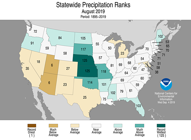
August Precipitation

- Above-average precipitation was observed across 12 states including Oregon and Maine and from the northern Plains to the Gulf Coast. Nebraska and Kansas were wettest on record for August.
-
Below-average precipitation stretched from California to Texas and across parts of Michigan and Maryland. Arizona and Utah ranked sixth driest on record for August.
-
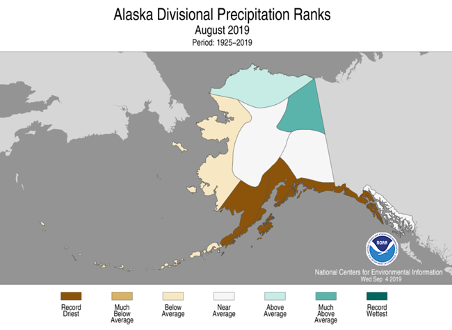
In Alaska, it was the driest August on record at Anchorage, Kenai, Seward, King Salmon, Sitka, Talkeetna, and Yakutat. Contrasting with the dry conditions, Denali National Park Headquarters had its wettest August on record with 9.53 inches of precipitation reported.
-
In late August, Hurricane Dorian developed from a tropical wave and brought heavy winds and rain to parts of Puerto Rico and the U.S. Virgin Islands.
-
As Dorian continued its northwestward track into the open waters of the Atlantic Ocean, it strengthened significantly, eventually reaching Category 5 strength with peak sustained winds of 185 mph, making it one of the five strongest (based on wind speeds) hurricanes on record in the Atlantic Basin.
-
On September 1, Dorian made initial landfall on Great Abaco Island in the Bahamas at Elbow Cay followed by Marsh Harbour later in the day, attaining peak wind intensity during landfall. Dorian’s 185-mph landfalling wind speed ties with the Labor Day Hurricane of 1935 as the strongest landfalling Atlantic hurricane on record.
-
Dorian slowed to a crawl on September 2, still at Category 5 intensity, as the storm made landfall over Grand Bahama. Dorian’s eyewall hovered over Grand Bahama as the hurricane pummeled the island for more than 24 hours, prior to moving northwestward toward the contiguous U.S. East Coast as a strong, yet less intense, hurricane.
-
-
According to the September 3 U.S. Drought Monitor report, 10 percent of the contiguous U.S. was in drought, up almost 7 percent from the end of July. Drought conditions expanded or intensified across parts of the southern Plains, the Southwest, the middle Mississippi Valley, and across portions of the Great Lakes, while improvements were seen across parts of Hawaii and Puerto Rico. In Alaska, drought conditions improved across the Northeast Interior, but intensified in the south central portion of the state.
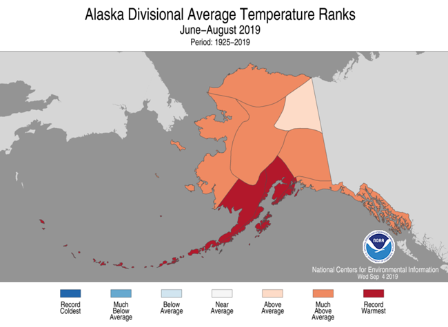
Summer (June–August) Temperature

- Above- to much-above-average summer temperatures spanned from the West Coast to the Southwest and into the Deep South, as well as from the Gulf Coast to New England. Delaware, New Jersey, and Florida ranked fifth warmest, while New Mexico ranked sixth warmest. No state ranked below average for the summer season.
-
The Alaska statewide average temperature for the summer was 54.6°F, 4.1°F above average and ranked as the second warmest such period on record. Record warm temperatures were observed across much of the southern and southwestern divisions with above- to much-above-average temperatures dominating the rest of the state.
-
Anchorage had its warmest summer on record with an average temperature of 63.2°F, 1.8°F warmer than the previous warmest summer, in 2004.
-
Kodiak, King Salmon, Iliamna, Cold Bay, and Talkeetna (tied with 2004) also had their warmest summer on record.
-
Summer (June–August) Precipitation

- Above- to much-above-average precipitation was observed from the northern Great Plains to the Gulf Coast and from the Ohio Valley into the Northeast. South Dakota had its fifth wettest June–August, while Kentucky experienced its sixth wettest such period on record.
-
Below- to much-below-average precipitation was observed across much of the West as well as in Iowa and upper Michigan. Arizona had its driest summer on record receiving about 40 percent of its seasonal average. California, New Mexico, and Utah had the tenth driest, or drier, summer.
-
Anchorage, Seward, King Salmon, Talkeetna, and Cordova each had their driest summer on record, while Utqiaġvik reported its wettest June–August period on record with 5.43 inches, exceeding the previous record of 5.26 inches, set in 1989.
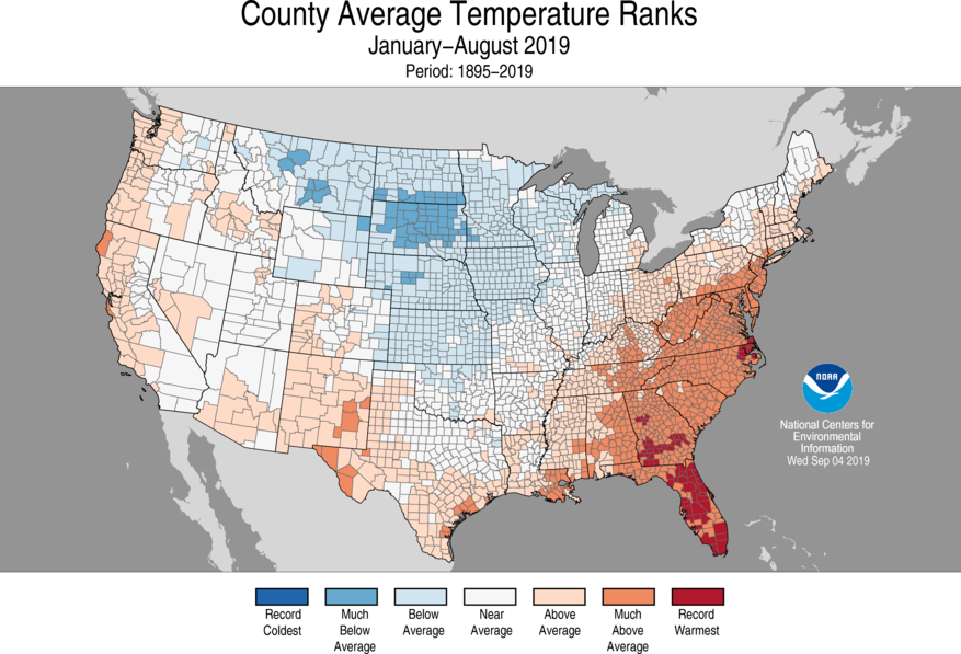
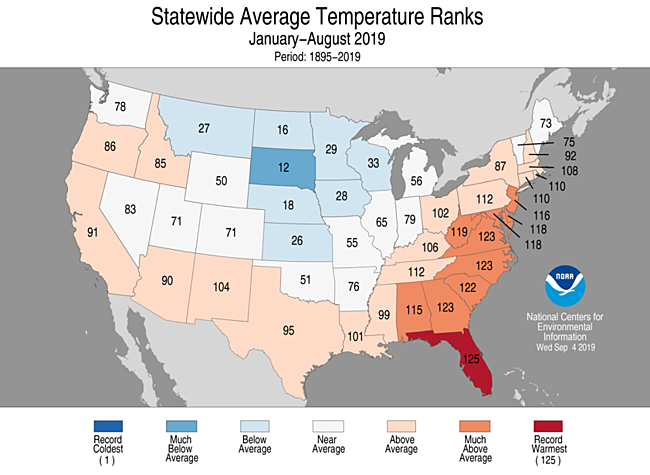
Year-to-date (January–August) Temperature

- Above- to much-above-average year-to-date temperatures were observed across portions of the West, Southwest, southern Plains, and from the Gulf of Mexico to parts of New England. The year-to-date average temperature for Florida tied with 2017 as the warmest such period on record while Georgia, North Carolina, and Virginia ranked third warmest.
-
Below- to much-below-average temperatures were observed across the northern and central Plains and Upper Midwest. South Dakota ranked 12th coolest for this year-to-date period.
-
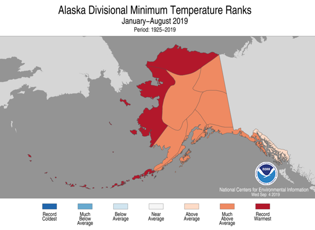
Year-to-date temperatures were above normal across Alaska, with record warmth in the northern and western coastal divisions.
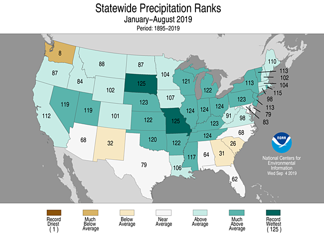
Year-to-date (January–August) Precipitation

- Above- to much-above-average January–August precipitation stretched from coast-to-coast with both South Dakota and Missouri ranking wettest on record. Illinois, Indiana, Ohio, and Tennessee each ranked second wettest for this year-to-date period.
-
Washington state ranked eighth driest, while New Mexico, Georgia, and South Carolina ranked in the driest third of the historical record.
-
The total number of wildfire acres consumed across Alaska in 2019 now exceeds 2.59 million acres, which is the sixth highest number of acres consumed across Alaska in the past 50 years.
-
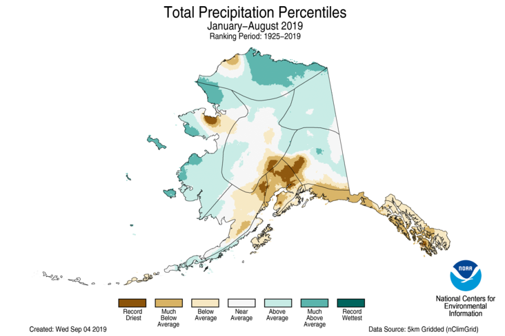
January–August precipitation was drier than normal across southern coastal Alaska to the panhandle, with record dry conditions in the south central parts of the state.
See all August U.S. temperature and precipitation maps.


