
Contiguous U.S. tied as second warmest September on record

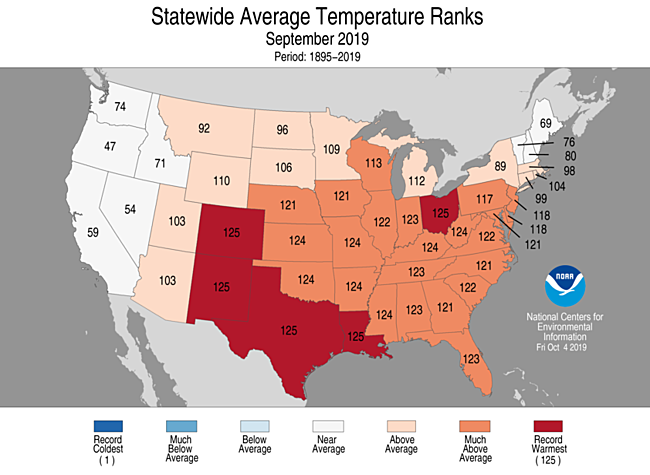
For September, the average contiguous U.S. temperature was 68.5°F, 3.7°F above the 20th century average, tying with 2015 as the second warmest September in the 125-year period of record. The warmest September on record occurred in 1998 and was 0.5°F warmer than in 2019. Record heat was observed across parts of the central and southern Rocky Mountains, the southern Plains, and portions of the Midwest and Ohio Valley. For the year-to-date, the contiguous U.S. temperature was 55.8°F, 0.8°F above the 20th century average, ranking in the warmest third of the January–September record.
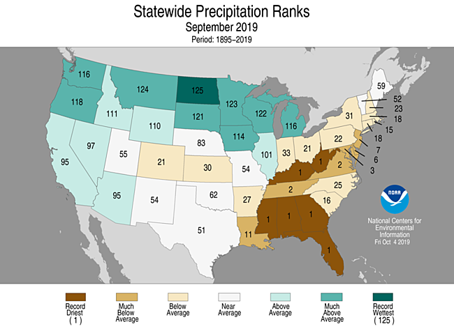
The September precipitation total for the contiguous U.S. was 2.42 inches, 0.07 inch below average, ranking in the middle third of the 125-year period of record. Record wet conditions occurred across the Northern Tier and southeast Texas while record dry conditions were present across the Ohio Valley and the South. For the year-to-date, the national precipitation total was 27.06 inches, 3.86 inches above average, the wettest January–September on record.
NCEI has updated the 2019 billion-dollar weather and climate disaster list to include four additional events — Hurricane Dorian, Tropical Storm Imelda, the Southern and Eastern tornadoes/severe weather, and the Arkansas River flooding. This brings the year-to-date total to 10 weather and climate disaster events with losses exceeding $1 billion each across the U.S. This is the fifth consecutive year (2015–2019) in which 10 or more billion-dollar disasters have impacted the U.S. — the first such occurrence on record.

This monthly summary from NOAA National Centers for Environmental Information is part of the suite of climate services NOAA provides to government, business, academia, and the public to support informed decision-making.
September Temperature

-
Most of September was dominated by a trough along the West Coast, bringing more moderate temperatures to the region, and a ridge of high pressure over the eastern contiguous U.S., amplifying the warmth from the Rockies to the East Coast.
-
Above- to much-above-average September temperatures were observed across all but eight of the Lower 48 states. Record warm average monthly temperatures occurred across five states — Colorado, New Mexico, Texas, Louisiana, and Ohio — with 22 additional states having a top 10 warm month.
-
Near-average temperatures were present across the West and across northern New England.
-
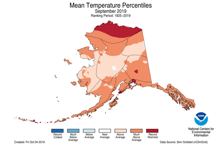
Alaska had its third warmest September on record with a statewide average temperature of 44.7°F, 4.1°F above the long-term average. Record warmth was observed across the North Slope with above- to much-above-average temperatures blanketing nearly all of the state. Utqiaġvik and Cold Bay reported their warmest September on record.
September Precipitation

-
The trough along the West Coast enhanced precipitation along the Northern Tier while the ridge of high pressure over the eastern contiguous U.S. was responsible for the very dry conditions across the South and Southeast.
-
Above- to much-above average precipitation was observed across parts of the West, the northern Plains, and portions of the Great Lakes. North Dakota had its wettest September on record.
-
Pronounced dry conditions across the South, Ohio Valley and parts of the mid-Atlantic contributed to a “flash drought” which emerged during September. Six states — Mississippi, Alabama, Georgia, Florida, Kentucky, and West Virginia — were record driest for the month with five additional states ranking among their driest 10 Septembers on record.
-
Hurricane Dorian made landfall at Hatteras, North Carolina, on September 6 as a Category 1 hurricane with maximum sustained winds estimated near 90 mph. The storm grazed the East Coast from central Florida to the Outer Banks and continued on a path which eventually made landfall in Nova Scotia with 100 mph sustained winds.
-
Tropical Storm Imelda* made landfall on September 18 near Freeport, Texas, just 45 minutes after becoming a tropical storm. Imelda weakened into a depression and, due to its slow movement, brought large amounts of heavy rainfall to southeastern Texas over the ensuing four days. Widespread areas of between two and three feet of rain fell during this time with the largest storm total of 43.39 inches reported at North Fork Taylors Bayou, Texas.
-
A significant winter storm brought widespread areas of one to two feet of snow, blizzard conditions, and bitter cold temperatures to parts of Idaho, Montana and Wyoming during September 28–September 30. The largest storm total reported was 52.0 inches in Babb, Montana, with several other stations reporting nearly four feet of snow. Many September snowfall and cold temperature records were broken over the course of this event.
-
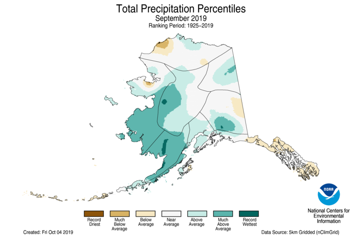
Alaska’s average of 5.55 inches of precipitation in September was 0.98 inch above average and ranked in the wettest third of the 95-year record. Southwestern and southcentral Alaska received above-average precipitation, which helped to alleviate the short-term drought across the region. Below-average rainfall was present across southeast Alaska, the eastern Gulf Coast, and Kodiak Island, where drought remains intact.
-
According to the October 1 U.S. Drought Monitor report, 19 percent of the contiguous U.S. was in drought, up 9 percent from the beginning of September. Drought conditions improved across the Pacific Northwest, Midwest, and Great Lakes regions, yet expanded or intensified across the Southwest, Texas, Ohio and Tennessee valleys and across the Southeast. Across Alaska, above-normal rainfall helped alleviate the short-term drought across much of the south-central region and in part of the Northeast Gulf region. Drought intensified across portions of Hawaii, but contracted in others to cover a smaller statewide footprint. Drought contracted across southern Puerto Rico.
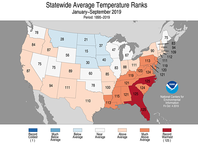
Year-to-date (January–September) Temperature

-
Above- to much-above-average year-to-date temperatures were observed from the West Coast to the Gulf Coast and throughout the Southeast and much of the East Coast. Georgia and Florida had their warmest January–September on record while North Carolina tied with 2017 for warmest year-to-date on record. South Carolina, Virginia, and Alaska ranked second warmest. Near- to below-average temperatures were observed across the Great Basin, northern Rockies, central and northern Plains, as well as across the Great Lakes.
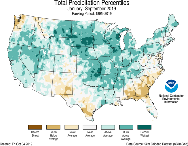
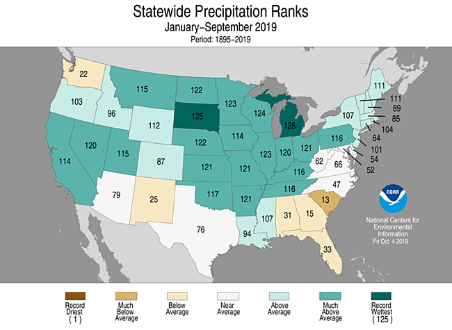
Year-to-date (January–September) Precipitation

-
Above- to much-above-average January–September precipitation stretched from the West Coast to New England. South Dakota had its wettest year-to-date on record, exceeding the previous record, set in 1915, by 1.67 inches. Michigan also ranked wettest on record for the January–September period. Fifteen additional states ranked among their 10 wettest such periods on record. Below-average precipitation fell across parts of the Northwest, South, and Southeast, where South Carolina had its 13th driest year-to-date on record.
*Note on Tropical Storm Imelda precipitation: As is typical with very heavy rainfall events, localized bands of very heavy rain may not be completely captured by the gauge-based observing network, the basis for this analysis. This can lead to an under-representation of actual rainfall totals. This can be compounded by disruptions to the observers' ability to report values during or following a severe event and several of our long-term reporting stations have missing data for this event. Additionally, quality assurance routines may flag large valid values as erroneous, resulting in underestimated values. NCEI is working to ensure all valid reports are indeed validated. As a result, a more final accounting for the precipitation which fell across Texas during September will be available with the October report.