
An early-February winter storm impacted much of the contiguous U.S.; drought conditions across the western U.S. exacerbated by dry winter

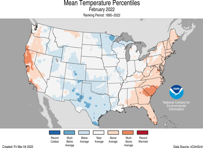
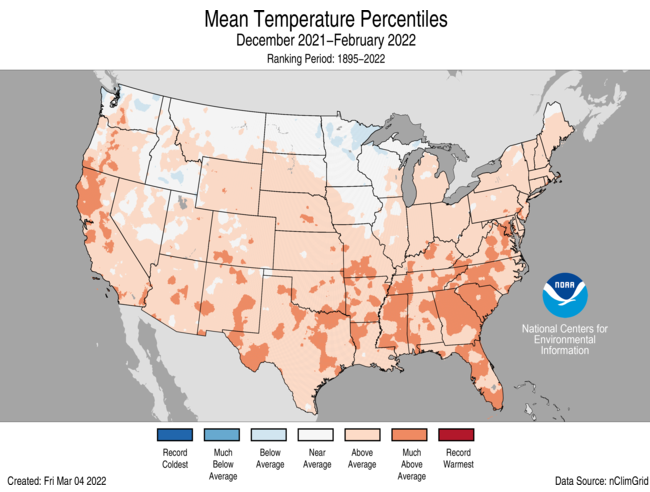
During February, the average contiguous U.S. temperature was 33.8°F, 0.1°F below the 20th-century average, ranking in the middle third of the 128-year period of record. The winter (December-February) average contiguous U.S. temperature was 34.8°F, 2.5°F above average, ranking in the warmest third of the winter record.
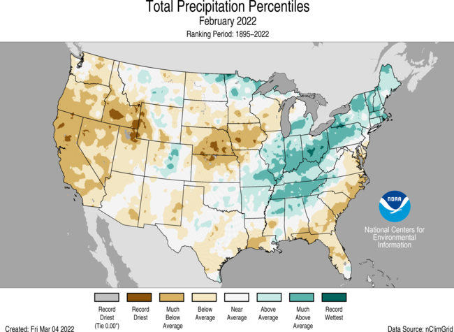
The February precipitation total for the contiguous U.S. was 1.73 inches, 0.40 inch below average, and ranked in the driest third of the historical period of record. The winter precipitation total was 5.76 inches, 1.03 inches below average, and ranked as the 12th-driest winter in the 127-year period of record.
A massive winter storm stretched from Texas to Maine during the first week of February and brought heavy snow, freezing rain, ice and bitter cold temperatures to much of the eastern two-thirds of the Lower 48. Power outages across many states were the result of fallen power lines and trees. Thousands of flights were canceled amid treacherous travel conditions. More than a foot of snow fell across parts of the Northeast.

This monthly summary from NOAA National Centers for Environmental Information is part of the suite of climate services NOAA provides to government, business, academia and the public to support informed decision-making.
February
Temperature

- Temperatures were below average across portions of the northern Plains and western Great Lakes as well as from the central Rockies to the Gulf Coast. Temperatures were above average across portions of the West Coast and from the Southeast to New England.
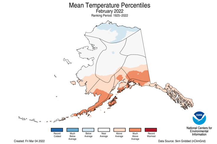
- The Alaska statewide February temperature was 8.6°F, 3.8°F above the long-term average. This ranked among the middle one-third of the 98-year period of record for the state.
- Temperatures were below average across parts of the North Slope while above-average temperatures were observed across the southern third of the state. King Salmon ranked fifth-warmest while Anchorage and Kodiak had their sixth-warmest February on record.
- Bering Sea ice extent in February was the highest value observed since 2013, but fell rapidly the last 10 days of the month and was slightly below the 1991-2020 median by March 2.
Precipitation

- Precipitation was above average from the Mid-Mississippi Valley to New England. Ohio had its sixth-wettest February. Precipitation was below average across most of the West and portions of the Plains, Southeast and Mid-Atlantic. California and Nebraska each had their second-driest February with Nevada ranking third driest.
- The state of Alaska, as a whole, ranked as the wettest February in the 98-year record. Juneau had its wettest February following its wettest January on record. King Salmon also experienced its wettest February on record, while Anchorage ranked second-wettest. Snowpack was above normal across most of the state.
- According to the March 1 U.S. Drought Monitor report, 59.2 percent of the contiguous U.S. was in drought, up nearly 4 percent from the beginning of February. Drought conditions expanded or intensified across portions of the northern and central Plains, as well as across parts of the West, Midwest, Great Lakes and from Florida to the Carolina coast. Drought contracted on the Big Island of Hawaii, but expanded across the islands of Kauai and O’ahu. Drought severity lessened across portions of the southern Plains and across Puerto Rico.
Winter (December-February)
Temperature

- Winter temperatures were above average across much of the Lower 48 with Georgia and South Carolina experiencing their seventh-warmest winter on record. Temperatures ranked near average from the Pacific Northwest to the western Great Lakes with no states ranking below average for the winter season.
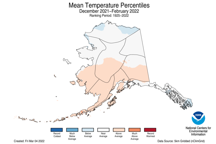
- The Alaska December-February temperature was 6.3°F, 2.7°F above the long-term average, ranking among the middle one-third of the 97-year record. Above-average temperatures were observed across the Aleutians, Bristol Bay, Cook Inlet and the southern half of the West Coast, Central Interior and Southeast Interior regions. Temperatures were below average across portions of the North Slope and the southern Panhandle.
Precipitation

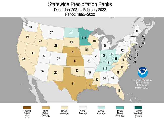
- Precipitation was above average across parts of the Upper Mississippi, Ohio, and Tennessee valleys. Minnesota had its 10th-wettest winter. Precipitation was below average across portions of the West, central and southern Plains, Gulf Coast and across parts of the Southeast and Mid-Atlantic. Louisiana had its third-driest winter on record with Nebraska ranking fourth driest and Kansas, fifth driest.
- Climatologically speaking, winter is the wet season across much of the western U.S. If the dry conditions experienced in January and February across portions of the West were to continue into March and April, insufficient water resources may result during the dry season (summer), as well as an increased potential for drought intensification and wildfires in the fall.
- Five regions in Alaska — Bristol Bay, West Coast, North Slope, Northeast Interior and Southeast Interior — ranked wettest on record for the winter season, contributing to a record-wet winter for the state of Alaska, eclipsing the previous record set in 1928-29. Nome experienced its wettest winter since 1943-44, and King Salmon had its wettest winter on record.
For more detailed climate information, check out our comprehensive February 2022 U.S. Climate report scheduled for release on March 11, 2022.