International Satellite Cloud Climatology Project (ISCCP) Climate Data Record, H-Series
Cloud Properties - ISCCP; HXS, HXG, HGG, HGH, HGM, B1U
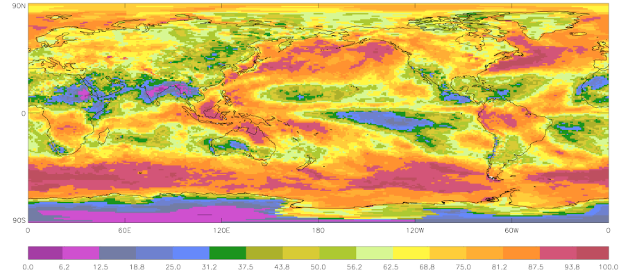 2009 - January Mean Cloud Amount (Sample)
The International Satellite Cloud Climatology Project (ISCCP) focuses on the distribution and variation of cloud radiative properties to improve the understanding of the effects of clouds on climate, the radiation budget, and the long-term global hydrologic cycle.
The ISCCP H-Series Climate Data Record consists of several parts:
(1) ISCCP H-Series dataset,
(2) ISCCP-Basic H-Series, and
(3) Ancillary and input datasets.
ISCCP H Series data
The full ISCCP dataset consists of netCDF files containing various derived cloud parameters. The H-Series data includes several products. These include:
* HXS (H-series pixel level single satellite - not in netcdf),
* HXG (H-series pixel level gridded),
* HGG (H-series Gridded Global),
* HGH (H-series gridded monthly by hour), and
* HGM ( H-series Gridded Monthly).
The netCDF files are not structured with CF-standard names. Data variables are unitless and rely on data tables that are needed to represent each geophysical variable. Keeping ISCCP H-Series in this native format ensures that existing "power users" will be able to continue using the data.
ISCCP Basic H Series
ISCCP Basic files contains a subset of the cloud variables and products available in the full ISCCP dataset. It consists of remapped, calibrated, and subsetted variables following CF-conventions. In addition, the netCDF files follow full netCDF CF and ACDD Conventions. These files are intended to be use by new and/or less advanced users that may want to use cloud data, but do not need the full ISCCP dataset.
Ancillary and Input data
Ancillary and Input data used in the production of ISCCP are also archived. These consist of B1U geostationary satellite data, B1U and GAC calibration/HBT tables, and ancillary files for nnHIRS, AEROSOL, SNOWICE, and OZONE datasets.
Dataset Citation
- Cite as: Rossow, W.B.; Walker, A.; Golea, V.; Knapp, K. R.; Young, A.; Inamdar A.; Hankins, B.; and NOAA's Climate Data Record Program (2016): International Satellite Cloud Climatology Project Climate Data Record, H-Series [indicate subset used] NOAA National Centers for Environmental Information. [access date]. doi:10.7289/V5QZ281S
Dataset Identifiers
- doi:10.7289/V5QZ281S
- NCEI DSI 2010_01
- gov.noaa.ncdc:C00956
ISO 19115-2 Metadata
gov.noaa.ncdc:C00956
| Download Data |
|
| Distribution Formats |
|
| Ordering Instructions | Contact NCEI for other distribution options and instructions. |
| Distributor |
NOAA National Centers for Environmental Information ncei.info@noaa.gov |
| Dataset Point of Contact | Customer Engagement Branch NOAA National Centers for Environmental Information 1-828-271-4800 ncei.orders@noaa.gov |
| Dataset Point of Contact | NOAA Climate Data Record Program Office DOC/NOAA/NESDIS/NCEI > National Centers for Environmental Information, NESDIS, NOAA, U.S. Department of Commerce +1 828-271-4800 ncdc.isccp.team@noaa.gov |
| Time Period | 1982-01-01 to Present (time interval: 3-hour) |
| Spatial Reference System | urn:ogc:def:crs:EPSG::4326 |
| Spatial Bounding Box Coordinates |
West: -180.0
East: 180.0
South: -90.0
North: 90.0
|
| Spatial Coverage Map |
| General Documentation |
|
| Processing Documents |
|
| Associated Resources |
|
| Publication Dates |
|
| Edition | v01r00 |
| Data Presentation Form | Digital image |
| Dataset Progress Status | Planned - fixed date has been established upon or by which the data will be created or updated |
| Data Update Frequency | Quarterly |
| Purpose | The resulting datasets and analysis products are being used to improve understanding and modeling of the role of clouds in climate, with the primary focus being the elucidation of the effects of clouds on the radiation balance. These data can also used to support many other cloud studies, including understanding of the hydrological cycle. |
| Use Limitations |
|
| Dataset Citation |
|
| Cited Authors |
|
| Principal Investigators |
|
| Collaborators |
|
| Publishers |
|
| Theme keywords |
Global Change Master Directory (GCMD) Science Keywords
|
| Data Center keywords |
Global Change Master Directory (GCMD) Data Center Keywords
|
| Platform keywords |
Global Change Master Directory (GCMD) Platform Keywords
|
| Instrument keywords |
Global Change Master Directory (GCMD) Instrument Keywords
|
| Place keywords |
Global Change Master Directory (GCMD) Location Keywords
|
| Project keywords |
Global Change Master Directory (GCMD) Project Keywords
|
| Data Resolution keywords |
Thesaurus title not available.
|
| Stratum keywords |
Global Change Master Directory (GCMD) Location Keywords
|
| Use Constraints |
|
| Access Constraints |
|
| Fees |
|
| Lineage information for: dataset | |
|---|---|
| Lineage Statement | The data were produced as a joint effort between NASA Goddard and the NOAA National Centers for Environmental Information (NCEI) and are archived at NCEI. ISCCP was established in 1982 as part of the World Climate Research Programme (WCRP) to collect and analyze satellite radiance measurements to infer the global distribution of clouds, their properties, and their diurnal, seasonal, and interannual variations. Data are collected from an international suite of weather satellites and merged into the ISCCP Climate Data Record Product. |
| Processor |
|
| Processing Steps |
|
| Processing Environment | Cooperative Institute for Climate and Satellites (CICSNC/NOAA/NCEI) |
| Processing Documents |
|
| Source Datasets |
|
| Lineage information for: repository | |
|---|---|
| Processing Steps |
|
Last Modified: 2023-08-10
For questions about the information on this page, please email: ncei.info@noaa.gov
For questions about the information on this page, please email: ncei.info@noaa.gov