Temperature, conductivity, and water currents data collected by CTDs and current meters on moored buoys in the Sermilik Fjord, Greenland from 2011-08-20 to 2012-09-16 (NCEI Accession 0126772)
 Preview graphic
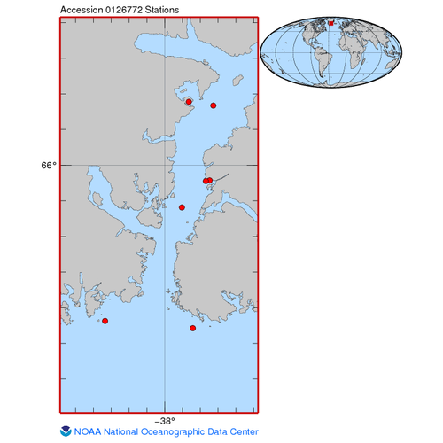
The data included in this dataset were collected in the Sermilik Fjord, located in East Greenland in the Ammassalik district close to the town of Tasiilaq. Data collection was conducted by deploying six moorings from August 2011 to September 2012. The seven moorings were named CM1SF5, CM2SF6, OE1, OW1, SF1, SF3, and SF4. Mooring CM1SF5 was located mid-fjord at a depth of 129 meters and was equipped with an SBE MicroCAT. Mooring CM2SF6 was located next to CM1SF5 at a depth of 265 meters. It was equipped with an SBE MicroCAT. Two moorings were positioned outside the fjord, OE1 was located on the east side of the fjord entrance at a depth of 255 meters and OW1 was located on the west side at a depth of 252 meters. Mooring OE1 was equipped with an RBR DR-150 Depth Recorder, five Onset UTBI-001 TidbiT Temperature Loggers, and an RBR XR-420 CTD. Mooring OW1 was outfitted with only an SBE MicroCAT. Mooring SF1 was located at the north end of the fjord at a depth of 630 meters. Data recovered from this mooring included three SBE MicroCAT and an RDI ADCP. Mooring SF3 was positioned near the glacier at a depth of 15 meters and was outfitted with an SBE MicroCAT and an Onset UTBI-001 Tidbit Temperature Logger. Mooring SF4 was positioned in the middle of the fjord at a depth of 860 meters. Data collected from this mooring included two RBR XR-420s, five Onset UTBI-001 Temperature Loggers, one SBE MicroCAT, and an RDI ADCP.
- Cite as: Straneo, Fiamma; Sutherland, Dave; Harden, Benjamin; Jackson, Rebecca (2015). Temperature, conductivity, and water currents data collected by CTDs and current meters on moored buoys in the Sermilik Fjord, Greenland from 2011-08-20 to 2012-09-16 (NCEI Accession 0126772). [indicate subset used]. NOAA National Centers for Environmental Information. Dataset. https://www.ncei.noaa.gov/archive/accession/0126772. Accessed [date].
| Download Data |
-
HTTPS (download)
Navigate directly to the URL for data access and direct download.
-
FTP (download)
These data are available through the File Transfer Protocol (FTP). FTP is no longer supported by most internet browsers. You may copy and paste the FTP link to the data into an FTP client (e.g., FileZilla or WinSCP).
-
THREDDS (download)
These data are available through a variety of services via a THREDDS (Thematic Real-time Environmental Distributed Data Services) Data Server (TDS). Depending on the dataset, the TDS can provide WMS, WCS, DAP, HTTP, and other data access and metadata services as well. For more information on the TDS, see http://www.unidata.ucar.edu/software/thredds/current/tds/.
-
HTTPS (download)
Navigate directly to the URL for data access and direct download.
-
FTP (download)
These data are available through the File Transfer Protocol (FTP). FTP is no longer supported by most internet browsers. You may copy and paste the FTP link to the data into an FTP client (e.g., FileZilla or WinSCP).
|
| Distribution Formats |
|
| Ordering Instructions |
Contact NCEI for other distribution options and instructions. |
| Distributor |
NOAA National Centers for Environmental Information
+1-301-713-3277
NCEI.Info@noaa.gov
|
| Dataset Point of Contact |
NOAA National Centers for Environmental Information
ncei.info@noaa.gov
|
| Time Period |
2011-08-20 to 2012-09-16 |
| Spatial Bounding Box Coordinates |
West: -38.3343
East: -37.727
South: 65.5423
North: 66.1777
|
| Spatial Coverage Map |
|
| General Documentation |
|
| Associated Resources |
- Harden, B. E., Straneo, F., & Sutherland, D. A. (2014). Moored observations of synoptic and seasonal variability in the East Greenland Coastal Current. Journal of Geophysical Research: Oceans, 119(12), 8838–8857. https://doi.org/10.1002/2014jc010134
- Jackson, R. H., Straneo, F., & Sutherland, D. A. (2014). Externally forced fluctuations in ocean temperature at Greenland glaciers in non-summer months. Nature Geoscience, 7(7), 503–508. https://doi.org/10.1038/ngeo2186
- Straneo, Fiamma; Woods Hole Oceanographic Institution (2014). Temperature and conductivity data collected by CTDs on moored buoys in the Sermilik Fjord, Greenland from 2008-07 to 2009-08 (NCEI Accession 0123217). NOAA National Centers for Environmental Information. Dataset. https://www.ncei.noaa.gov/archive/accession/0123217.
- Straneo, Fiamma; Woods Hole Oceanographic Institution (2015). Temperature and conductivity, and water currents data collected by CTDs and current meters on moored buoys in the Sermilik Fjord, Greenland from 2010-08 to 2011-08 (NCEI Accession 0123282). NOAA National Centers for Environmental Information. Dataset. https://www.ncei.noaa.gov/archive/accession/0123282.
|
| Publication Dates |
- publication: 2015-03-25
- revision: 2015-08-21
|
| Data Presentation Form |
Digital table - digital representation of facts or figures systematically displayed, especially in columns
|
| Dataset Progress Status |
Complete - production of the data has been completed
Historical archive - data has been stored in an offline storage facility |
| Data Update Frequency |
As needed |
| Supplemental Information |
In this accession, NCEI has archived multiple versions of these data. The latest (and best) version of these data has the largest version number.
Additional data from this mooring in Sermilik Fjord, Greenland is available in accessions 123217 (2008-2009), 123282 (2010-2011) and 125646 (2011-2012). |
| Purpose |
The overreaching goal of this work is to understand the glacier/ocean interactions in Greenland's glacial fjord both to explain the recent and ongoing changes, and to improve our ability to make future predictions (of sea level rise in particular). |
| Use Limitations |
- Distribution liability: NOAA and NCEI make no warranty, expressed or implied, regarding these data, nor does the fact of distribution constitute such a warranty. NOAA and NCEI cannot assume liability for any damages caused by any errors or omissions in these data. If appropriate, NCEI can only certify that the data it distributes are an authentic copy of the records that were accepted for inclusion in the NCEI archives.
|
| Dataset Citation |
- Cite as: Straneo, Fiamma; Sutherland, Dave; Harden, Benjamin; Jackson, Rebecca (2015). Temperature, conductivity, and water currents data collected by CTDs and current meters on moored buoys in the Sermilik Fjord, Greenland from 2011-08-20 to 2012-09-16 (NCEI Accession 0126772). [indicate subset used]. NOAA National Centers for Environmental Information. Dataset. https://www.ncei.noaa.gov/archive/accession/0126772. Accessed [date].
|
| Cited Authors |
|
| Contributors |
|
| Resource Providers |
|
| Publishers |
|
| Acknowledgments |
- Related Funding Agency: National Science Foundation (NSF)
|
| Theme keywords |
NODC DATA TYPES THESAURUS
NODC OBSERVATION TYPES THESAURUS
WMO_CategoryCode
Global Change Master Directory (GCMD) Science Keywords
|
| Data Center keywords |
NODC COLLECTING INSTITUTION NAMES THESAURUS
NODC SUBMITTING INSTITUTION NAMES THESAURUS
Global Change Master Directory (GCMD) Data Center Keywords
|
| Platform keywords |
NODC PLATFORM NAMES THESAURUS
Global Change Master Directory (GCMD) Platform Keywords
|
| Instrument keywords |
NODC INSTRUMENT TYPES THESAURUS
Global Change Master Directory (GCMD) Instrument Keywords
|
| Place keywords |
NODC SEA AREA NAMES THESAURUS
Global Change Master Directory (GCMD) Location Keywords
|
| Project keywords |
NODC PROJECT NAMES THESAURUS
Global Change Master Directory (GCMD) Project Keywords
|
| Keywords |
NCEI ACCESSION NUMBER
|
| Use Constraints |
- Cite as: Straneo, Fiamma; Sutherland, Dave; Harden, Benjamin; Jackson, Rebecca (2015). Temperature, conductivity, and water currents data collected by CTDs and current meters on moored buoys in the Sermilik Fjord, Greenland from 2011-08-20 to 2012-09-16 (NCEI Accession 0126772). [indicate subset used]. NOAA National Centers for Environmental Information. Dataset. https://www.ncei.noaa.gov/archive/accession/0126772. Accessed [date].
|
| Access Constraints |
- Use liability: NOAA and NCEI cannot provide any warranty as to the accuracy, reliability, or completeness of furnished data. Users assume responsibility to determine the usability of these data. The user is responsible for the results of any application of this data for other than its intended purpose.
|
| Fees |
- In most cases, electronic downloads of the data are free. However, fees may apply for custom orders, data certifications, copies of analog materials, and data distribution on physical media.
|
| Lineage information for: dataset |
|---|
| Processing Steps |
- 2015-03-25T17:00:22Z - NCEI Accession 0126772 v1.1 was published.
- 2015-08-21T05:33:02Z - NCEI Accession 0126772 was revised and v2.2 was published.
Rationale: Updates were received for this dataset. These updates were copied into the data/0-data/ directory of this accession. These updates may provide additional files or replace obsolete files. This version contains the most complete and up-to-date representation of this archival information package. All of the files received prior to this update are available in the preceding version of this accession.
|
| Output Datasets |
- NCEI Accession 0126772 v1.1
- NCEI Accession 0126772 v2.2
|
| Lineage information for: dataset |
|---|
| Processing Steps |
- 2015-03-27T13:20:41Z - NCEI accession 0125646 was superseded by this accession.
Rationale: NCEI accession 0125646 has been superseded by this accession. Please use and refer to this accession instead of NCEI accession 0125646.
|
| Lineage information for: dataset |
|---|
| Processing Steps |
- Data Type: WATER TEMPERATURE (measured); Units: degrees C; Observation Type: in situ; Sampling Instrument: CTD - moored CTD; Sampling and Analyzing Method: Data were collected using SBE MicroCAT-37, RBR XR-420 CTD, and Onset UTBI-001 TidbiT.; Data Quality Information: Data collected before and after instrument was in the water were removed. Any spikes in data were replaced with NaNs. Flag values were assigned to data.
- Data Type: CONDUCTIVITY (measured); Units: siemens; Observation Type: in situ; Sampling Instrument: CTD - moored CTD; Sampling and Analyzing Method: Data were collected using SBE MicroCAT-37 and RBR XR-420 CTD.; Data Quality Information: Data collected before and after the instrument was in the water were removed. Any spikes in data were replaced with NaNs. Flag values were assigned to data.
- Data Type: PRESSURE - WATER [HYDROSTATIC PRESSURE] (measured); Units: decibar; Observation Type: in situ; Sampling Instrument: CTD - moored CTD; Sampling and Analyzing Method: Data were collected using SBE MicroCAT-37, RBR XR-420 CTD, and an RBR DR-1050 Depth Recorder.; Data Quality Information: Data collected before and after the instrument was in the water were removed. Any spikes in data were replace with NaNs. Flag values were assigned to data. Drifts in pressure were corrected using a low pass filter.
- Data Type: CURRENT METER - EAST-WEST COMPONENT (U) (measured); Units: m/s; Observation Type: in situ; Sampling Instrument: ADCP; Sampling and Analyzing Method: Data were collected using an RDI-ADCP.; Data Quality Information: Data collected before and after instrument was in water were removed. Flag values were assigned to data. Magnetic declination was applied using the IGRF model.
- Data Type: CURRENT METER - NORTH-SOUTH COMPONENT (V) (measured); Units: m/s; Observation Type: in situ; Sampling Instrument: ADCP; Sampling and Analyzing Method: Data were collected using an RDI-ADCP.; Data Quality Information: Data collected before and after the instrument was in the water were removed. Flag values were assigned to data. Magnetic declination was applied using the IGRF model.
- Data Type: CURRENT METER - DIRECTION (calculated); Units: degree; Observation Type: in situ; Sampling Instrument: ADCP; Sampling and Analyzing Method: Data were calculated from current velocity data collected using an RDI-ADCP.
- Data Type: CURRENT METER - SPEED (calculated); Units: m/s; Observation Type: in situ; Sampling Instrument: ADCP; Sampling and Analyzing Method: Data were calculated from current velocity data collected using and RDI-ADCP.
|
| Lineage information for: repository |
|---|
| Processing Steps |
- 2015-04-22T00:00:00 - NOAA created the National Centers for Environmental Information (NCEI) by merging NOAA's National Climatic Data Center (NCDC), National Geophysical Data Center (NGDC), and National Oceanographic Data Center (NODC), including the National Coastal Data Development Center (NCDDC), per the Consolidated and Further Continuing Appropriations Act, 2015, Public Law 113-235. NCEI launched publicly on April 22, 2015.
|
| Acquisition Information (collection) |
|---|
| Instrument |
- ADCP
- CTD
- CTD - moored CTD
|
| Platform |
|
Last Modified: 2024-04-05T15:25:35Z
For questions about the information on this page, please email:
ncei.info@noaa.gov