 National Temperature
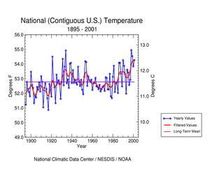
The contiguous United States was much warmer than average in 2001. The
preliminary 2001 average annual temperature was 54.3° F (12.4° C),
which was 1.5° F (0.8° C) above the 1895-2001 mean; the sixth
warmest in the record. The warmest year on record was in 1998, just four
years ago.
|
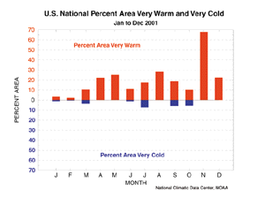
The adjacent figure shows the percent of the contiguous U.S. that was
very warm and the percent that was very cold during each of the past 12
months. A tenth or more of the country averaged very warm for each month
from March to December, with May and August each exceeding 25 percent.
During November 2001, two-thirds of the country averaged very warm,
which contrasts sharply with November and December of last year when
more than half of the country was unusually cold. Very warm and very
cold conditions are defined as the warmest and coldest ten percent of
recorded temperatures, respectively.
|
larger image
|

larger image
|
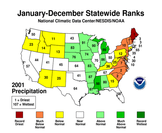
For the period January through December 2001, a large portion of the conterminous United States experienced above normal temperatures. Temperatures in 14 states, located in the North and West, ranked among the top ten warmest in the 1895 to present record. Utah experienced
their fourth warmest year in the record. Only seven states in the southeastern portion
of the nation averaged near normal for this period.
|

National Precipitation
larger image
|
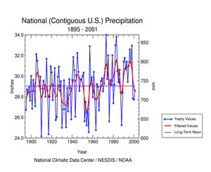
Precipitation was slightly below average for the conterminous United
States in 2001. The preliminary January-December national precipitation
average was 28.6 inches (726.4 mm), which was 0.5 inches (12.7 mm) below
the long term mean; 40th driest in the 1895-2001 record. Two-thousand
one marked the third consecutive year of below normal precipitation,
following nine years of precipitation surpluses.
|
|
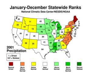
Maine experienced their driest year on record
for 2001 and it was among the ten driest years on record for eight other east
coast states. For the period January through December 2001, most east
coast states and many western states had precipitation deficits placing
them in the bottom third portion of the historical distribution. In
contrast, some states from the upper Midwest southward along the
Mississippi River Valley generally received above normal precipitation,
most notably Michigan, Mississippi and Louisiana.
|
larger image
|
Drought and Wildfires
 larger image
|
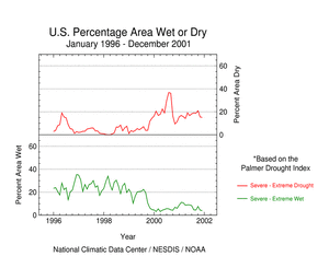
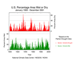
On a national scale, long-term drought (as measured by the Palmer
Drought Index) gradually expanded from about 15% of the country in the
severe to extreme categories in January to a peak of 20% in October
2001. A series of Pacific storms brought rain and snow to much of the
western drought areas beginning late autumn, resulting in a decrease in
the drought area to about 15% of the contiguous U.S. by the end of
December.
|
The percent of the country in the severe to extreme wet spell categories
(as measured by the Palmer Drought Index) peaked early in the year at
about 11% in February but gradually decreased to about 4% of the country
by the end of the year.
|
The 2001 national drought had its origins in late 1999. At its peak in
August 2000 this drought, when compared to other droughts of the 20th
Century, was as extensive as the major droughts of the last 40 years,
but not as large as the "dust bowl" droughts of the 1930's and 1950's.
The duration of the current national drought (about 26 months) falls in
between the duration of the 1970's and late 1980's droughts.
|
 larger image
|
 larger image
|
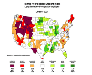
At its widest expanse in 2001, drought affected about 20% of the
contiguous U.S. The areas most severely affected included parts of the
southern Great Plains, much of the western U.S. and, by December,
much of the eastern seaboard.
|
|
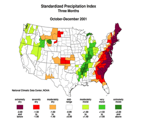
Extremely dry conditions during November through March (see graph below right) resulted in the second driest rainy season in the last 107 years for the Pacific Northwest. Only 1976-77 was drier. Many rivers reached record low streamflow levels and reservoirs were depleted to meet water demand. Three states (Washington, Oregon, and Idaho) declared drought emergencies. A series of Pacific storms near the end of autumn brought a beneficial snowpack to the mountains and a wet start to the 2001-2002 rainy season (see graph below left).
|
|
The combination of hot, dry, windy conditions and high-altitude dry thunderstorms sparked thousands of new wildfires in August. During the first 20 days of the month, about 1.23 million acres were blackened in the Great Basin, Pacific Northwest, and northern California, increasing the national year-to-date total to 2.83 million acres (103% of the 10-year average).
|
|
The eastern seaboard, from Georgia to Maine, experienced very dry conditions during 2001. The drought resulted in record low streamflows, low or dry wells, low reservoirs, and severe stress on crops. Several states declared statewide burning bans, drought alerts were announced for numerous counties, and several communities implemented water use restrictions. The very dry conditions during October led to hundreds of small wildfires in many eastern states from Kentucky and Virginia to South Carolina, and also in Massachusetts.
|
 larger image
|
|
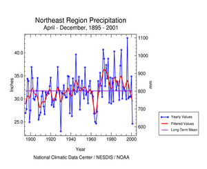
In the Northeast
region, nine of the months in 2001 were drier to much drier than normal,
but the drought can be traced back to late summer 2000 (see graph below
left). Wet conditions interrupted the drought during March and June.
Nevertheless, 2001 had the second driest April-December
and October-December,
third
driest July-December, and fourth
driest year in the last 107 years. Record or near-record low
streamflows and groundwater in Maine raised the concerns
of power companies, water utilities, and homeowners with shallow wells.
In 2001, Maine had a record dry October-December as well as the driest
year on record, resulting in the most severe statewide Palmer
Drought Index in the last 100 years. By early November, Upper
Delaware Basin reservoir storage
declined to drought warning levels, triggering emergency
reductions in Delaware River flow targets and water diversions to New
York City and New Jersey. According to the USGS
in Baltimore, Maryland, low rainfall and warm temperatures in November
contributed to record low streamflow and ground-water levels.
Streamflow into the Chesapeake Bay was the lowest for November since
records began in 1937, and just below the previous record set in 1964.
|
|
Parts of the Southeast
have suffered from drought for much of the last 4 years (see graph below
left). In 2001, eight of the months were drier or much drier than
normal. Heavy rains brought drought relief to the region in March, and
much of the Gulf coast got a summer reprieve beginning in June with
copious rainfall from Tropical Storm Allison. But dry conditions
returned with a vengeance in October, giving the region the third
driest October-December and 20th driest year (see graph below right)
on record. Drought was blamed as the cause for one of the worst
shrimping seasons on record in Georgia, and water restrictions were
implemented in some Georgia cities by September. South Carolina
Forestry officials reported that January 2001 had more wildfire activity
than any January in the last 15 years, and the state had the second
driest year on record. In February, the Governor of Mississippi
issued a ban on all outdoor open burning because of concerns over a
recent rash of wildfires. Dry conditions and abundant fuel in the form
of fallen leaves set the stage by mid-November for the worst
wildfire season in a decade in the Appalachian mountain region.
|
 larger image
|
|
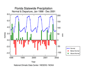
The year started dry for Florida, continuing a drought that had begun
nearly four years earlier. Hydrological impacts included reduced streamflow, lake, and groundwater levels. Over 3100 wildfires burned more than 335,300 acres (135,700 hectares) during the first five months of the year, including a fire that closed a 17-mile section of Interstate 4, a heavily traveled route between Orlando and Tampa. Lake Okeechobee dropped to record low levels by early March. In response to the worst drought conditions since the 1930's, emergency mandatory water-use restrictions were in effect in many Florida communities. Relief came in March with heavy rains, but it wasn't until several tropical systems dropped copious rainfall during the summer that much of the state was pulled out of drought.
|
Severe Storms

larger image
|
There were 8 very strong to violent tornadoes (wind speeds in excess of 158 mph, category F3-F5) during the 2001 tornado season (March-August). This is well below the long-term (1950-2000) mean of 38 and is the lowest such tornado count in the last 51 years. The previous record was nine violent tornadoes in 1987. Little trend in very strong to violent tornadoes has been observed since 1950.
|
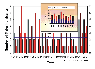
| There were 15 named tropical storms in 2001, nine of which became hurricanes with four reaching major hurricane strength. On average, between nine and ten named storms form with six growing to hurricane strength and two developing into major hurricanes. A tendency for greater hurricane activity has occurred over the past six years after more than two decades of generally below-average activity.
|
 larger image
|
| Five or more major hurricanes occurred three times in the 90's; 1995, 1996 and 1999. (A major hurricane is defined as category 3 or higher according to the Saffir-Simpson scale. A category 3 hurricane has winds 111-130 mph). Prior to 1995, five or more major Atlantic hurricanes had not occurred in one season since 1964. A new record number of hurricanes for November was set in 2001 as Michelle, Noel and Olga all were active in the Atlantic Basin during the month. The contiguous U.S. has not been hit directly by a hurricane now for the past two years, although tropical storms have caused significant damage, as evidenced by Tropcial Storm Allison. This storm, the costliest tropical storm on record ($5 billion in damage), caused severe flooding in Texas and Louisiana before moving across the Southeast and up the East Coast. |
 larger image


 larger image
 larger image
 larger image
 larger image
 larger image
 larger image
 larger image
 larger image
 larger image
 larger image
 larger image

 larger image