National Overview:
- Temperature Highlights - November
- The average
 November temperature of 46.5°F was 4.0°F above the 20th Century average and ranked as the 3rd warmest based on preliminary data.
 - On the
 regional level, the
 East North Central experienced its third warmest November on record. Other regions that were above normal were the
  Northeast, which had its fourth warmest, and both the
 Central and
  West North Central each had their eighth warmest such period.
 - Much above normal temperature averages dominated
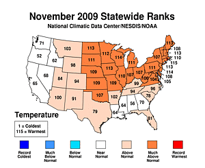 statewide.
  Delaware experienced its warmest November on record,
 Wisconsin and
 New Jersey its second warmest, and five states had its third warmest such period (
 Maine,
 New Hampshire,
 Massachusetts,
 Iowa, and
 North Dakota). 18 other states that had an average temperature that ranked in the top ten. There was not a single state that averaged below normal temperatures for the month.
 - Precipitation Highlights - November
- The U.S. recorded its
 18th driest November in the 115-year period of record. Precipitation was especially sparse in the
 West North Central, where it was third driest November based on data that dates back to 1895.
  Statewide ranks were variable with the Atlantic Coast states of
 Virginia averaging its second wettest,
 North Carolina its sixth wettest, and
 South Carolina its ninth wettest November on record. For the rest of the U.S., nine states had their top ten driest November. There were 25 states in all with precipitation totals below the long-term mean.
 - For the
 autumn period (September-November) persistent wetness dominated the
 South and
 Southeast states.
 Arkansas has its wettest fall on record. During the
 three-month period, a total of ten states had an average precipitation value that ranked in the top ten, while much of the Southwest was much-below normal.
 - Other Items of Note
- November was a quiet month for tornadoes in the U.S. with only 4 preliminary reports. November 2009 was the slowest November since 1980, which had 3 tornadoes, and tied for 3rd quietest since extensive records began in 1950. The autumn as a whole was also calm with only 80 tornadoes reported in the U.S., compared to the 2006-2008 year average of 164.
- Based on NOAA's Residential Energy Demand Temperature Index (REDTI), the contiguous U.S. temperature-related energy demand was 16.1 percent below average in November, which was the fourth lowest November value in 115-years. For the Fall season (September-November), the model indicated that the national residential energy consumption was 2.9 percent below average.
 November
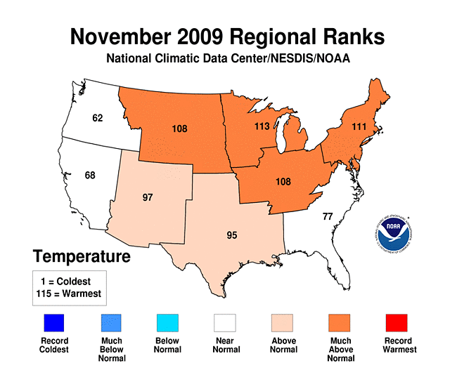 regional level
 East North Central
 Northeast
 Central
 West North Central
 statewide
 Delaware
 Wisconsin
  New Jersey
  Maine
Maine New Hampshire
 Massachusetts
 Iowa
Iowa North Dakota
 18th driest November
 West North Central
 Statewide ranks
 Virginia
 North Carolina
 South Carolina
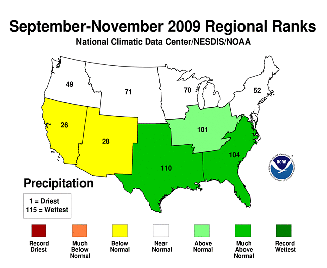 autumn period
 South
South Southeast
 Arkansas
 three-month period
-
 Alaska
had its 31st coolest November since records began in 1918, with a
temperature 2.7°F (1.5°C) below the 1971–2000
average.
Alaska
had its 31st coolest November since records began in 1918, with a
temperature 2.7°F (1.5°C) below the 1971–2000
average.
-
 Alaska
had its 32nd warmest September–November on record, with a
temperature 1.6°F (0.9°C) above the 1971–2000
average.
Alaska
had its 32nd warmest September–November on record, with a
temperature 1.6°F (0.9°C) above the 1971–2000
average.
-
 Alaska
had its 27nd warmest January–November on record, with a
temperature 0.6°F (0.4°C) above the 1971–2000
average.
Alaska
had its 27nd warmest January–November on record, with a
temperature 0.6°F (0.4°C) above the 1971–2000
average.
 Alaska
 Alaska
 Alaska
For additional details about recent temperatures and precipitation across the U.S., see the Regional Highlights section below. For information on local temperature and precipitation records during the month, please visit NCDC's Records page. For details and graphics on weather events across the U.S. and the globe please visit NCDC's Global Hazards page.
Regional Highlights:
These regional summaries were provided by the six Regional Climate Centers and reflect conditions in their respective regions. These six regions differ spatially from the nine climatic regions of the National Climatic Data Center.
- Northeast Region: (Information provided by the Northeast Regional Climate Center)
- Temperatures during the first week of November were near or below normal, continuing the trend of the previous two months. This pattern changed around the 7th when the trough over the Northeast was replaced by a more zonal flow that kept cold air to the north of the region until the end of the month. The result was a warmer than normal November for Northeast residents, in fact, it was the 6th warmest November since 1895. The average temperature this month was 43.7 degrees F (6.5 degrees C), which was 4.5 degrees F (2.5 degrees C) above normal. This was 4.4 degrees F (2.4 degrees C) warmer than November 2008 and the warmest November since 2001. Among the states, temperature departures ranged from 3.9 degrees F (2.2 degrees C) above normal in Delaware to 5.5 degrees F (3.1 degrees C) above normal in Maine. A list of the November temperature rankings for each state is below. November was warm enough to offset the cool temperatures of September and October, yielding an average of 50.3 degrees F (10.2 degrees C) for the Fall of 2009. This was 0.8 degrees (0.4 degrees C) above the 1971-2000 average.
- Precipitation was quite variable in the Northeast. Delaware and Maine were the wettest states, with 138 and 128 percent of normal precipitation, respectively. Pennsylvania (42 percent of normal) and West Virginia (48 percent of normal) were the driest this month. Overall, the Northeast saw 2.67 inches (68 mm) of precipitation, which was 71 percent of the normal November amount. The 5.03 inches (128 mm) that fell on the 14th in Portland, ME established a new daily rainfall record for November. The previous record was 4.70 inches (119 mm) set on November 10, 1990. Fall 2009 averaged drier than normal. The three-month total of 9.90 inches (251 mm) was 89 percent of normal.
- The remnants of Hurricane Ida impacted coastal areas from Maryland to New York from the 11th to the 13th. Heavy rain, damaging winds and high surf closed roads, caused power outages and eroded beaches. There were 4 reported fatalities due to the storm, one surfer in New York and 3 commercial fishermen in New Jersey. The following is a brief assessment of the storm from the New Jersey State Climatologist: The water pushed to the coast resulted in tides as much as three feet above normal, with waves of 5-10 feet (1.5-3.0 m) atop these tides. This resulted in major damage to beaches and dunes and considerable flooding of some coastal communities from overflowing back bays. There has yet to be a full assessment of damage, though the total may ultimately exceed one hundred million dollars. This was one of the worst storms to impact the coast in the past several decades, particularly from Cape May to Long Beach Island. The one major theme through fall (September-November) 2009 was the pounding taken by NJ coastal beaches. This began with the powerful storm of September 10th-11th, continued with another bout of strong onshore winds from October 15th-17th and included the signature event of November 11th-13th. Suffice it to say that New Jersey's beaches and coastal communities are in a more vulnerable position as we head into the winter storm season than has been seen in quite a number of years.
- For more information, please go to the Northeast Regional Climate Center Home Page.
- Midwest Region: (Information provided by the Midwest Regional Climate Center)
- November temperatures were above normal across the Midwest. The warmth was a big change from October, which ranked as the seventh coolest in the past 115 years across the Midwest with all nine states ranking among the 15 coolest. Preliminary numbers indicate November ranks as the fifth warmest for the Midwest as a whole. Eight of nine states ranked the month in the top 10 warmest: Illinois 7, Indiana 9, Iowa 3, Kentucky 18, Michigan 6, Minnesota 3, Missouri 7, Ohio 10, and Wisconsin 5. Temperatures ranged from about 2 degrees F (1 degrees C) above normal in Kentucky up to 11 degrees F (6 degrees C) above normal in Minnesota. 242 record high maximum temperatures and 436 record high minimum temperatures were set in November. November totals of 678 record highs and just 4 record lows was a big change from October totals of 32 record highs and 1698 record lows. The cool October and warm November temperatures offset each other and the fall season as a whole was near normal for most of the region. Fall temperatures were within 2 degrees F (1 degrees C) of normal for all but northern Minnesota and Wisconsin and parts of upper Michigan. The warmest fall temperatures were in northwest Minnesota where it was up to 5 degrees F (3 degrees C) above normal.
- November precipitation was below normal across most of the Midwest. Parts of Minnesota, Wisconsin, and Kentucky received less than 25 percent of normal precipitation. Only parts of northern Minnesota and a swath along the Iowa-Missouri border and across central Illinois exceeded 75 percent of normal November precipitation. A narrow swath in west central Illinois received more than 125 percent of normal precipitation. Following a wet October, the first two weeks of November were relatively dry with less than 1 inch (25 mm) of precipitation across the Midwest. A cutoff low lingered over Missouri for several days bringing rainfall totals of 3-4 inches (75-100 mm) across northern Missouri and central Illinois for the period November 15th to 20th. Fall precipitation was highly variable with October ranking as the wettest in the last 115 years while September and November ranked among the top-20 driest years in the same period. Two Midwest states recorded top-15 wettest falls, Illinois (12th) and Missouri (sixth). Each of the other seven Midwest states recorded both a top-20 driest and a top-20 wettest month this fall: Indiana, fifth wettest October, 17th driest November; Iowa, 15th driest September, record wettest October; Kentucky, 11th wettest September, third wettest October, third driest November; Michigan, seventh driest September, fifth wettest October, ninth driest November; Minnesota, 12th driest September, third wettest October; Ohio, 17th wettest October, fifth driest November; Wisconsin, fourth driest September, third wettest October, 11th driest November.
- Harvest of soybeans was nearly complete by the end of November. Corn harvest was nearly complete in Kentucky but the other Midwest states were 10 to 28 percent behind the 5-year averages. Wisconsin (28 percent) and Illinois (27 percent) had the largest departures from the 5-year averages.
- For details on the weather and climate events of the Midwest, see the weekly summaries in the MRCC Midwest Climate Watch page.
- Southeast Region: (Information provided by the Southeast Regional Climate Center)
- Monthly average temperatures for November 2009 were normal to above normal across much of the region. Temperatures were 2 to 4 degrees F (1.1 to 2.2 degrees C) above normal across Virginia, much of North Carolina, NW South Carolina, and a small portion of North Georgia. Temperatures were 2 to 4 degrees F (1.1 to 2.2 degrees C) above normal across the southern two-thirds of Alabama, southwestern Georgia, and small portions of Florida and South Carolina. There were no exceptionally cold outbreaks during the month. In fact, only 9 daily minimums across the region tied or broke records during the month, and most of these occurred in Florida. Crestview, Florida recorded a daily record minimum of 28 degrees F (-2.2 degrees C) on the 27th of the month. The warmest temperatures of the month occurred during the first week at most locations. Effingham, South Carolina recorded a daily maximum of 87 degrees F (30.6 C) on the 1st of the month. There were a modest 81 daily maximum temperature records tied or broken during the month. The monthly average temperature across Puerto Rico was close to normal.
- A marked north to south gradient was observed in monthly precipitation across the region. Precipitation totals were more than 200 percent of normal across much of Virginia, the northeastern third of North Carolina, and small portions of South Carolina and Georgia. In contrast, precipitation was less than 75 percent of normal across much of Florida as well as southern Alabama and Georgia. Vero Beach, Florida received only 0.30 inches (76 mm) of precipitation for the month, which is about 8 percent of the normal. The pattern of frequent cyclone and frontal passages that began during October continued into November. The centers of at least four cyclones tracked across the region during the month, an unusually high number for the month. Richmond and Norfolk, Virginia received 9.60 inches and 9.20 inches (244 and 234 mm) of precipitation, respectively, for the month in records that extend back to 1930 and 1946. The heaviest precipitation occurred in conjunction with the landfall of Tropical Storm Ida in Alabama on the 10th and its metamorphosis into a nor'easter off of the Carolina Coast on the 11th. Over 3.00 inches (76 mm) of rainfall occurred across much of Georgia and South Carolina, as over 4.00 inches (102 mm) of precipitation occurred across portions of North Carolina and Virginia. Morehead City, North Carolina and Norfolk, Virginia received 8.85 inches and 7.80 inches (225 and 198 mm) of precipitation, respectively, in the event. San Juan Puerto Rico received over 12.00 inches (305 mm) of precipitation for the month, which ranks as the third wettest November in a record extending back to 1956.
- The area of moderate drought conditions across the eastern half of North Carolina and northeastern South Carolina contracted to a small area of abnormally dry conditions during the month. This was largely the result the precipitation associated with Ida and its redevelopment as a nor'easter off of the coast. This brought widespread recovery to all reservoirs and most streams across central North Carolina, although a few groundwater wells had not fully recovered. The abnormally dry conditions across portions of Florida at the beginning of the month expanded slightly in coverage as a small portion of the area in east central Florida was moved to the moderate drought (D1) class.
- Although the weather pattern was active during the month, there were no reports of tornadoes and only a few isolated high wind reports in Florida and Virginia.
- Given the lack of exceptionally cold air, there was very little snow reported during the month. Mount Mitchell North Carolina recorded 2.0 inches (25 mm) of snow on the 27th of the month
- The exceptionally wet conditions across North Carolina delayed the harvest of remaining soybean and cotton crops.
- For more information, please go to the Southeast Regional Climate Center Home Page.
- High Plains Region: (Information provided by the High Plains Regional Climate Center)
- November 2009 was warm and dry across the High Plains Region which was in stark contrast to the record setting cold and wet weather of October. Many locations received little to no precipitation this month and average monthly temperature departures ranged from near normal in small portions of Colorado and Wyoming to 3 degrees F to 9 degrees F (1.7 degrees C to 5.0 degrees C) above normal in Kansas, Nebraska, and remaining portions of Colorado and Wyoming. The Dakotas even had average temperature departures of over 12 degrees F (6.7 degrees C). In addition, many of the same locations that ranked in the top 5 coolest Octobers on record ranked in the top 5 warmest Novembers on record. This month's warm location was Spearfish, South Dakota. After recording its third coolest October on record, Spearfish recorded its warmest November on record (1962-2009) with an average temperature of 47.2 degrees F (8.4 degrees C). This smashed the previous record of 43.0 degrees F (6.1 degrees C) set in 2001. Interestingly, in Spearfish, November was warmer than October which had an average temperature of only 41.1 degrees F (5.2 degrees C).
- November 2009 was drier than normal for the majority of the Region as many locations received little to no precipitation. Large areas of the Dakotas, Nebraska, and Wyoming received only 25 percent of normal precipitation. These dry conditions coupled with the warm temperatures allowed for farmers to make good progress towards harvesting of row crops, moving cattle onto stalks, and fall tillage. However, due to the high moisture content, the corn harvest remained delayed as many dryers were running at full capacity and some facilities were limiting the delivery of wet grain. The few locations that received near to above normal precipitation included pockets of Kansas, southeast Nebraska, and Colorado. A mid-month snow storm brought heavy snow to the Nebraska-Kansas border where snowfall rates of up to 1-2 inches (2.54-5.08 cm) per hour were recorded and the heaviest snowfall totals ranged from 5-10 inches (12.70-25.40 cm). The heavy snow led to reduced visibilities, slick roads, closed schools, and power outages.
- This month there was little change to the U.S. Drought Monitor for the High Plains Region. North Dakota, South Dakota, Nebraska, and Kansas remained drought free. In Colorado, the southwest corner continued to have moderate drought (D1) and much of the surrounding area in the western part of the state continued to have abnormally dry conditions (D0). But, according to the U.S. Seasonal Drought Outlook released November 19th, the drought conditions in the southwest corner of Colorado are expected to improve through February 2010.
- For more information, please go to the High Plains Regional Climate Center Home Page.
- Southern Region: (Information provided by the Southern Regional Climate Center)
- November, 2009 mean temperature averages proved to be quite variable over the Southern Region. In the north, temperatures were generally warmer than expected, with values ranging between 2 and 8 degrees F (1.11 and 4.44 degrees C) above the monthly normal. It was particularly warm in Oklahoma, which reported an average mean temperature of 52.9 degrees F (11.61 degrees C). This value was the ninth warmest November on record for the state since record keeping began in 1895. This was a big turnaround from last month which was the coldest October on record over the same period. In Arkansas, the average mean temperature was 54.1 degrees F (12.28 degrees C). This value was the 14th warmest November in the 1895-2009 period of record. In the southern half of the Southern Region, temperatures were generally near to slightly below normal. Most stations in the southern half of the region reported temperature values that fell within 2 degrees F (1.1 degrees C) of the monthly normal. The highest negative temperature anomalies were observed in the Florida Parishes of Louisiana, where values ranged between 2 and 4 degrees F (1.11 and 2.22 degrees C) below the monthly normal.
- After an extremely wet October, November 2009 provided very dry conditions throughout most the Southern Region. The majority of stations reported monthly precipitation values that ranged from 0 to 50 percent of normal. All six states reported state average values that fell below 2 inches (50.8 mm) of precipitation. In Arkansas, a total of 1.65 inches (41.9 mm) was received, which was the eighth driest November (1895-2009). Louisiana reported a state monthly total of 1.82 inches (46.2 mm), which was the 12th driest on record (1895-2009). Similar values occurred in both Tennessee and Mississippi, which received 1.88 inches (47.8 mm) and 1.83 inches (42.5 mm), respectively. For Tennessee, it was the 13th driest November on record (1895-2009), while for Mississippi it was the 14th driest (1895-2009). Although Oklahoma averaged only 0.7 inches (17.8 mm), it was just the 24th driest November on record (1895-2009). In Texas, the state average of 1.25 inches (31.8 mm) (38th 1895-2009) was somewhat misleading in that it was extremely dry throughout most of the state, except for in the southern tip, where precipitation totals ranged from near normal to almost four times the monthly allotment. The driest areas of the state included the Low Rolling Plains, Trans Pecos and High Plains climate divisions. Over a dozen stations in that corner of the state reported zero precipitation for the month. Conversely, the wettest area of the state occurred in a small region including most of the South Central and Upper Coast climate divisions. Many stations in that area reported over 5 inches (127 mm) of monthly precipitation. In the Upper Coast climate division, Matagorda received 6.34 inches (161 mm), or 2.15 inches (54.6 mm) above normal, while Victoria Regional airport, received 5.79 inches (147.1 mm) over the month, or 3.15 inches (80 mm) above normal. In the South Central climate division, Aransas received 7.80 inches (198.1 mm) or 4.28 inches (108.7 mm) above normal, while Coleto Creek reservoir reported 7.32 inches (186 mm) (normal not available) of precipitation in November.
- Despite low precipitation totals throughout much of the Southern Region, drought conditions changed very little from October, 2009 to November, 2009. Drought conditions improved slightly in the Upper Coast and South Central climate divisions of Texas, where precipitation totals were generally well above normal for the month. Conversely, the area of extreme drought that was present in south central Texas during the the preceding month has migrated slightly westward.
- A tornado was reported in Bowie County, Texas. The twister was rated EF1. According to the report, one mobile home was destroyed, while several others sustained damage.
- Due to the severe impact of heavy fall precipitation totals on agriculture in the Southern Region disaster declarations have been made in several Mississippi counties. According to Natchezdemocrat.com, 53 Louisiana parishes have also been identified as primary disaster areas.
- For more information, please go to the Southern Regional Climate Center Home Page.
- Western Region: (Information provided by the Western Regional Climate Center)
- Except for parts of coastal California, southwest Oregon and small isolated pockets, temperatures throughout the West were warmer than normal, especially in Montana and Wyoming. In Billings, Montana, and Casper and Lander, Wyoming, November was warmer than October. This had happened only once before in all three of these locations. Phoenix, Arizona, broke their all-time November temperature record of 95 degrees F (35 degrees C) with 96 degrees F (35.5 degrees C) on the third, as did Bozeman, Montana (airport) on the fifth, with 76 degrees F (24.4 degrees C).
- Precipitation was well below normal over nearly the entire region, except in the extreme Pacific Northwest and portions of southwest Montana and southwest New Mexico. Elko, Nevada, had their driest November in 80 years while both Casper, Wyoming, and Great Falls, Montana, recorded their second driest November on record. Conversely, Quillayute, on the northwest coast of WA, recorded their second wettest November going back 43 years and had only one day of no measurable rain for the month. A snowstorm on the 11th-12th brought November record daily precipitation (1.62 inches / 41.1 mm) and snow depth (16 inches / 40.6 cm) at the Montana State University site in Bozeman, and an all-time record for any month of 24 inches (61.0 cm) of snowfall.
- On November 6 a tornado (EF-0) with estimated winds at 65-85 mph (29-38 m/s) struck Lincoln, Oregon, damaging 11 structures with some significant roof damage and windows blown out. Path length was 150 yards (140 m) with a width of 80 yards (70 m).
- On November 19 a powerful storm slammed the Pacific Northwest with heavy rain (up to 6 inches / 152 mm) and wind gusts of 60 mph (27 m/s). The high winds brought down numerous trees causing nearly 12,000 people to be without power near Port Angeles, Washington.
- On November 20 strong frontal winds produced wind gusts to 83 mph (37 m/s) at the Reno, Nevada, National Weather Service office. Mountain winds reached 134 mph (60 m/s) about 100 miles (160 km) south of Reno. Blowing dust along Interstate 80 between Fernley and Lovelock, Nevada, led to an accident involving 4 tractor-trailers and 2 pickup trucks that killed one person and injured 6.
- On November 28 another dust storm near Picacho, Arizona, led to 5 accidents on Interstate 10 causing 2 fatalities and 1 serious injury
See NCDC's Monthly Extremes web-page for weather and climate records for the month of May. For additional national, regional, and statewide data and graphics from 1895-present, for May, the last 3 months or other periods, please visit the Climate at a Glance page.
PLEASE NOTE: All of the temperature and precipitation ranks and values are based on preliminary data. The ranks will change when the final data are processed, but will not be replaced on these pages. Graphics based on final data are provided on the Climate Monitoring Products page and the Climate at a Glance page as they become available.