

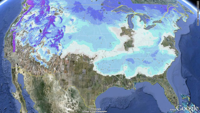
During January, temperatures were below normal across the eastern half of the country and near- to above normal for the western half. The combination of below-normal temperatures and several storms impacting the Eastern Seaboard caused the densely populated Northeast corridor to have above-average snowfall for the month — several locations broke long standing snowfall records. Two of these storms originated across the Gulf Coast states, bringing snowfall to a large swath of the Southeast. On January 11th, 49 of the 50 U.S. states had snow on the ground (all except Florida). While most of the East was experiencing above-average snowfall for January, many locations in the Plains as well as the mountain West experienced below-average snowfall. The contiguous U.S. as a whole had above-average snow cover extent for January, and the month had the fifth largest January snow cover extent on record (out of 45 years). According to the Rutgers Global Snow Lab, a NOAA supported facility, the monthly snow cover extent was 723,000 square km (279,000 square miles) above the long-term average of 3.5 million square km (1.4 million square miles). At the beginning of the month, 50.3 percent of the country was under snow cover — the high elevations of the West, the central and northern Plains, the western Great Lakes, the central and southern Appalachians, the Mid-Atlantic coast, and most of the Northeast. The monthly maximum snow cover extent occurred on January 12th when 70.9 percent of the nation was snow covered. By the end of the month, 41.6 percent of the U.S. had snow on the ground — the high elevations in the West, the Northern Plains, the Great Lakes, the Upper Mississippi River Valley, and the Northeast.
Select January 2011 Snowfall Records
| City | Record | Amount | Previous Record/ Comment |
| Huntsville, Alabama | Most consecutive days with snow on the ground | 8 days | 6 days - January 1988 |
| Huntsville, Alabama | Third largest snow storm on record | 8.9 inches (22.6 cm) | Largest: 17.1 inches - 1964 |
| Hartford, Connecticut | Snowiest month on record | 57.0 inches (144.8 cm) | 45.3 inches - March 1956 |
| New York, New York (Central Park) | Snowiest January on record | 36.0 inches (91.4 cm) | 27.4 inches - January 1925 |
| Newark, New Jersey | Snowiest January on record | 37.4 inches (96.3 cm) | 31.6 inches - January 1996 |
| Bridgeport, Connecticut | Snowiest January on record | 42.0 inches (106.7 cm) | 26.2 inches - January 1965 |
| Islip, New York | Snowiest January on record | 34.2 inches (86.9 cm) | 21.5 inches - January 2005 |
| South Bend, Indiana | Indiana all-time greatest 24-hour snowfall | 26 inches (66 cm) - January 8th | 22 inches - December 2006, Cannelton, IN |

A series of disturbances moving from central Canada across the Great Lakes cranked up the lake effect snow machine across Indiana between January 7th and 9th. A lake effect snow band set up coming off Lake Michigan into northern Indiana and southwestern Michigan, bringing heavy snow to the region. Snowfall rates of up to 4 inches (10.2 cm) per hour were reported. During the event, South Bend, Indiana reported 36.6 inches (93 cm) of snow on the 7th and 8th. This breaks the previous two-day snowfall record for the city of 29.0 inches (73.7 cm) which fell over January 30th and 31st, 1909. Also impressive, was the one day snowfall total of 26.0 inches (66 cm) which fell on the 8th, which broke the all-time record snowfall for a single day in South Bend and possibly for the entire state of Indiana. The previous state record for snowfall during a 24-hour period was 22 inches (54 cm), which was set in December 2006 in Cannelton, Indiana and the previous South Bend 24-hour snowfall occurred on January 30th, 1909 when 20 inches (51 cm) of snow fell. Records for South Bend date back to 1893.

Eastern U.S. Snow Accumulation 9-13 January
The first major winter storm complex during January impacted the eastern half of the United States between January 9th-13th, dropping over a foot (30.5 cm) of snow for many locations across the Central Plains, Midwest, Southeast, Mid-Atlantic, and Northeast. A significant freezing rain and icing event occurred across many portions of the South and Southeast. The event began across northeast Texas on the 9th where over 6 inches (15.2 cm) of snow accumulated. The upper level low pressure system progressed along the Gulf Coast, drawing moisture from the Gulf of Mexico causing a large precipitation shield over the Southeast. Parts of Mississippi, Arkansas, Tennessee, Alabama, and Georgia received over 10 inches (25.4 cm) of snow by the 10th. Huntsville, Alabama received 8.9 inches (22.6 cm) of snow, marking the third largest snow storm on record for the city. Parts of the Atlanta metropolitan area received eight inches (20 cm) of snow, shutting down the city for days. In the North Carolina mountains, up to 20 inches (51 cm) of snow were reported. The storm system then moved northward along the Atlantic Coast, bringing heavy snow to the population centers of the Northeast. Blizzard conditions were reported in Boston for several hours on the 12th. New York City received 9.1 inches (23 cm) of snow, while Boston, Massachusetts had 14.6 inches (37 cm). The 24 inches (61 cm) which fell at Bradley International Airport in Windsor Locks, Connecticut broke the previous all-time greatest storm record of 21.9 inches (56 cm), set on February 12th, 2006. Six states declared states of emergency. After the event, 49 of 50 U.S. states (all except Florida) had snow on the ground. The preliminary NESIS score, which measures the impact of snow on population centers, was a Category 3 (major). Please see the January Global Hazards report for more information on this storm.

Another major winter storm impacted the eastern U.S. between January 25th and 27th. Snowfall was reported from Arkansas to Maine. As the storm began to strengthen across the South, it dumped up to six inches (15 cm) of snow across western Kentucky and Tennessee. Unlike the previous winter storm, most of the precipitation across the Southeast fell as rain. As the system moved into the Northeast, it was cold enough to bring heavy snowfall to the central Appalachians, Mid-Atlantic, and Northeast. Heavy snowfall was reported across the D.C. metro area on the morning of the 26th, and five to eight inches (13 to 20 cm) accumulated there. The storm strengthened once it moved over the Atlantic, and dropped several feet of snow across the major cities of the Northeast. Central Park in New York City received 19.0 inches (48 cm) of snow, marking the eigth largest snow storm ever recorded in the city. The 15.1 inches (38.4 cm) that fell in Philadelphia tied as the city's tenth largest snowfall on record. This storm, in addition to previous storms during the month, caused several cities including Hartford, Connecticut and New York City to break their January monthly snowfall records. Please see the January Global Hazards report for more information on this storm.