Monthly Report Summary Information
The Monthly Report Summary Information is a synopsis of the collection of national and global summaries released each month.
National Summary Information - October 2015
See Full Report
For extended analysis of regional temperature and precipitation patterns,as well as extreme events, please see our full report that will be released on November 12th.

Significant climate events for October 2015
October 2015 was fourth warmest October for contiguous US
First ten months of 2015 were the sixth warmest on record for the Lower 48.
The October contiguous U.S. average temperature was 57.4°F, 3.3°F above the 20th century average, and the warmest October since 1963. Record and near-record warmth spanned the western half of the country. The October precipitation total for the contiguous U.S. was 2.75 inches, 0.59 inch above average and the 20th wettest on record. Near-record precipitation was observed in parts of the Southwest, Southern Plains, and Southeast. Historic flooding was observed across parts of the Carolinas in early October when tropical moisture associated with Hurricane Joaquin inundated the region.
This analysis of U.S. temperature and precipitation is based on data back to January 1895, resulting in 121 years of data.
U.S. climate highlights: October
Temperature
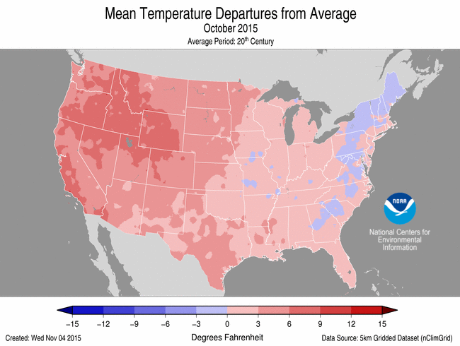
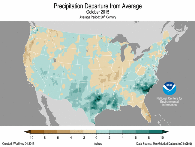
October 2015 Temperature Departure from Average
(top) and Precipitation Departure from Average (bottom)
- Fourteen states from the Great Plains to West Coast, including Alaska, had an October temperature that was much above average, with numerous locations within those states being record warm. Washington had its warmest October on record with a temperature of 52.8°F, 5.6°F above average, besting the previous record of 52.3°F set in 1988.
- Near-average October temperatures were observed across the Ohio Valley, Southeast, and Northeast, with below-average temperatures in parts of New England.
Precipitation
- Above-average precipitation was observed across the southern half of the contiguous U.S. from the Southwest, through the Southern Plains, and into the Southeast. Seven states had October precipitation totals that were much above average. South Carolina had its second wettest October with 10.36 inches of precipitation, 7.37 inches above average. Only October 1990 was wetter for the state when 11.56 inches of precipitation was recorded.
- Below-average October precipitation was recorded in parts of the Northwest, Ohio Valley, and Florida.
- According to the November 3rd U.S. Drought Monitor report, 26.2 percent of the contiguous U.S. was in drought, down about 5.2 percent compared to September 29th. Drought conditions dramatically improved across parts of the Southern Plains and Lower Mississippi River Valley where heavy precipitation flooded the region in late October. Drought also improved across the Southeast and in parts of the Northwest. Drought conditions worsened across parts of the Central Plains and Midwest. Precipitation was spotty across the West with long-term drought conditions continuing to plague the region.
Significant Events
- In early October, a strong low pressure system moved into the Southeast as Hurricane Joaquin moved off the East Coast. The two systems interacted, streaming deep tropical moisture into the Carolinas over a five-day period. Historic rainfall totals of 15-20 inches were widespread with localized totals greater than 25 inches around Charleston, South Carolina. The heavy rainfall caused significant flooding across the region, including coastal flooding that was exacerbated by strong onshore flow and astronomical high tides. The flooding resulted in over 400 roads, including Interstate Highways, being closed and at least 16 fatalities.
- In late October, several storm systems impacted the Southern Plains and Lower Mississippi River Valley, including the remnants of Hurricane Patricia. Heavy rainfall caused significant flooding across the region. On October 30th, Austin, Texas?s Bergstrom Airport was forced to close when 5.76 inches of rainfall was observed in one hour, adding to the calendar-day total of 14.99 inches. This was the second wettest day on record for the city. Texas as a whole had its fifth wettest October with 5.84 inches of precipitation, 3.31 inches above the 20th century average.
U.S. climate highlights: Year-to-date (January-October)
Temperature

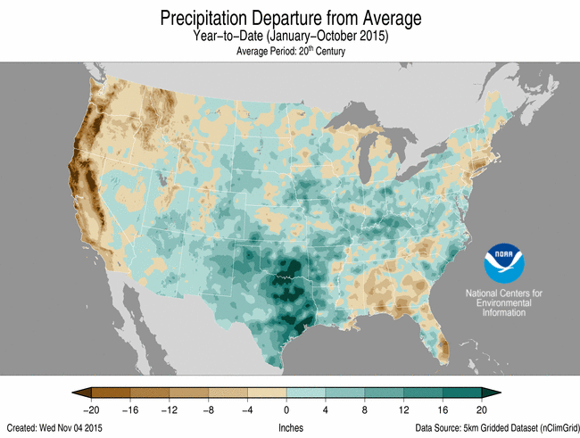
Jan-Oct 2015 Temperature Departure from Average (top)
and Precipitation Departure from Average (bottom)
- The year-to-date contiguous U.S average temperature was 57.0°F, 2.0°F above average, the sixth warmest on record. This was also the warmest year-to-date since 2012. Above-average temperatures were observed in the West and Southeast. Overall, 16 states, including Alaska, were much warmer than average. Arizona, California, Idaho, Montana, Nevada, Oregon, Utah, and Washington were each record warm. Below-average temperatures were observed in the Midwest and Northeast.
Precipitation
- The year-to-date precipitation total for the contiguous U.S. was 26.99 inches, 1.63 inches above average, and the 22nd wettest on record. Above-average precipitation was observed across the central U.S., where Kentucky, New Mexico, Oklahoma, and Texas were much wetter than average. No state was record wet for the year-to-date.
- Below-average precipitation was observed along both coasts. California, Connecticut, and Oregon each had precipitation totals that were much below average. California had its fourth driest year-to-date, while Oregon had its third driest.
Extremes
- The U.S. Climate Extremes Index (USCEI) for the year-to-date was 40 percent above average and the 13th highest value on record. On the national scale, extremes in warm maximum and minimum temperatures, one-day precipitation totals, and days with precipitation were much above average. The USCEI is an index that tracks extremes (falling in the upper or lower 10 percent of the record) in temperature, precipitation, land-falling tropical cyclones, and drought across the contiguous United States.
For extended analysis of regional temperature and precipitation patterns, as well as extreme events, please see our full report that will be released on November 12th.