Atlantic Basin
On July 5th, when Tropical Storm Dennis developed, it became the earliest date on record for 4 named storms to have formed in the Atlantic. Dennis also broke the record for the earliest development of a category 4 hurricane. With 5 named storms, July 2005 also set a new record for the most Atlantic named storms in any July.
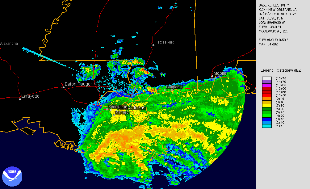
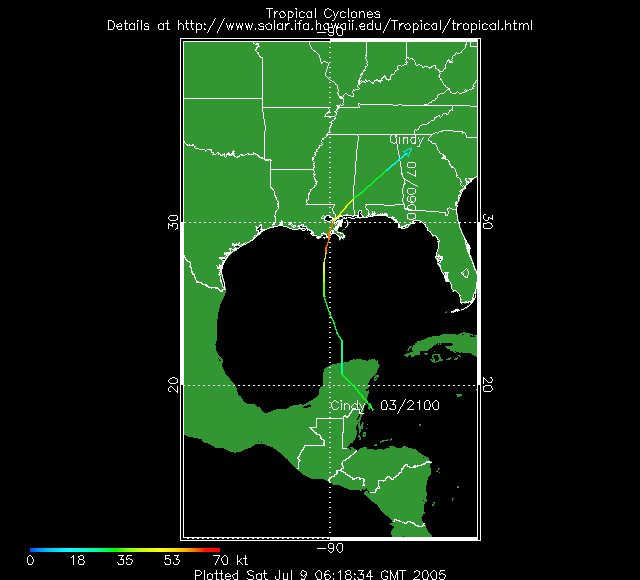
Tropical Storm Cindy, the third named storm of the season, formed during the morning of July 5th from a depression that had tracked across the Yucatan Peninsula and re-emerged over the central Gulf of Mexico during the previous 2 days. Cindy continued to track northwards and then northeastward through the day of July 5th to make landfall near Grand Isle, Louisiana with maximum sustained winds of near 70 mph. Heavy rainfall and inland flooding accompanied Cindy as it tracked northeastward across the eastern U.S., weakening to a tropical depression and ultimately dissipating.
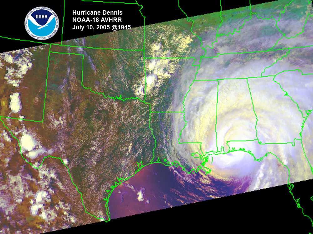
Hurricane Dennis also formed as a tropical storm on July 5th in the eastern Caribbean Sea. The storm strengthened to hurricane intensity on the 6th, prompting hurricane watches and warnings for Jamaica and southern Cuba. Rapidly intensifying further, Dennis tracked just to the north of Jamaica and grazed the southern coast of Cuba before making a landfall at category 4 strength in south-central Cuba on July 8th. Hurricane Dennis weakened as it crossed Cuba, but regained strength in the eastern Gulf of Mexico as it moved north-northwest towards the northeastern shores of the Gulf.

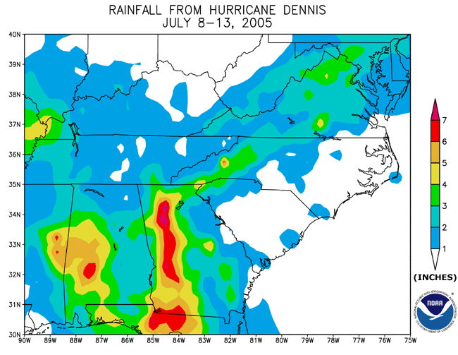
The storm reached category 4 strength again overnight on the 8th/9th and finally made a U.S. landfall near Pensacola, FL on July 10th as a category 3 storm. Windspeeds were approximately 120 mph at the time of landfall and led to over 400,000 power outages along the coast and inland in Mississippi, Alabama and Georgia. Heavy rainfall also resulted from the storm leading to localized flooding in parts of the Southeast. Partly as a result of rainfall associated with both Cindy and Dennis, Alabama and Georgia ranked 5th wettest on record for the month of July. For more information on impacts of the storm, please go see the Hazards report.
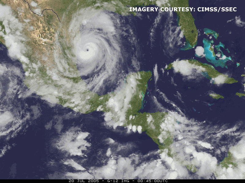
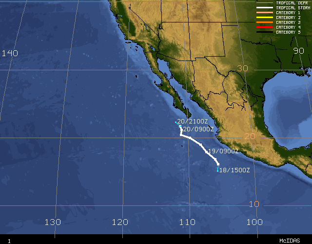
Emily developed into a tropical storm on July 12th east of the Lesser Antilles. Abruptly strengthening on July 14th, Emily became a hurricane as it passed near Grenada and then a major hurricane in the eastern Caribbean later that same day. The storm moved west-northwestward over the next several days and reached maximum windspeeds of 155 mph (near category 5 strength) and made landfall near Cozumel, Mexico, on the Yucatan Peninsula on July 18th with windspeeds of 135 mph. As Emily crossed the Yucatan, it weakened, then regained strength and became a major hurricane once again in the southwest Gulf of Mexico as it re-emerged over warm water. On July 20th, Emily made landfall in northeastern Mexico as a 125 mph-hurricane (category 3). Emily was a strong and long-lived hurricane registering a high Accumulated Cyclone Energy value, compared to other storms in July and the season as a whole. The ACE index is one measure of tropical activity.
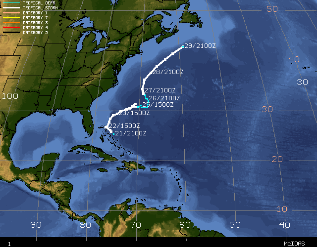
Tropical Storm Franklin formed on July 21st near the central Bahamas. The storm moved north and then northeast as it strengthened to its peak intensity of 70 mph. Over the next several days, Franklin weakened due to wind shear while moving towards Bermuda, eventually passing Bermuda to the west on July 26. Some reintensification occurred on July 27-28 bringing Franklin's winds to near 60 mph. As a frontal system moved off the east coast of the US and accelerated the tropical storm towards the northeast, causing it to weaken, Franklin became extratropical on the 29th south of Newfoundland.
Tropical Storm Gert reached maximum sustained windspeeds of 45 mph on July 24 after forming the previous day in the Bay of Campeche. As Gert made landfall near Cabo Rojo, Mexico, it brought heavy rainfall to those areas that had also been affected by Hurricane Emily less than a week earlier.
Accumulated Cyclone Energy (ACE) indices are available for all July storms.
Pacific Basin
July was relatively inactive in the eastern tropical Pacific with only two tropical storms forming during the month, compared to an average of four. The Accumulated Cyclone Energy (ACE) Index also indicated extremely low activity for July.
Tropical Storm Dora developed on July 4 about 45 miles west-southwest of Acapulco, Mexico. Maximum sustained winds were near 40 mph while Dora moved parallel to the Mexican coastline. Although Dora did not make landfall, heavy rain fell along the coast. Dora dissipated on the 6th.
Tropical Storm Eugene formed on July 18th about 250 miles south of Manzanillo, Mexico. A peak intensity of around 70 mph was reached as Eugene moved parallel to the coast. By July 20th however, the storm was already weakening over cooler waters and became a remnant low about 115 miles southwest of Cabo San Lucas late on the 20th.