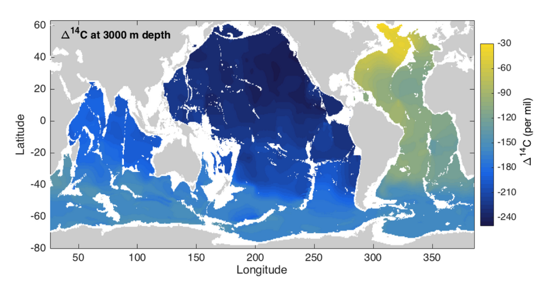
Neutrally Averaged Radiocarbon Climatology
Casimir de Lavergne1, Gurvan Madec2, Fabien Roquet3, Ryan M. Holmes1, Trevor J. McDougall1
1University of New South Wales, Australia
2Université Pierre et Marie Curie, France
3Stockholm University, Sweden
![]() Data Files
Data Files
![]() Documentation (PDF file)
Documentation (PDF file)

Abstract
This gridded product consists of a global (80°S-62°N) climatological estimate of radiocarbon content (∆14C) at half-degree horizontal resolution, provided both on neutral density and depth surfaces. It is based on the GLODAPv2 data compilation (Key et al. 2016, Olsen et al. 2016) and the neutral density (γn; Jackett and McDougall 1997) field of the WOCE global hydrographic climatology (Gouretski and Koltermann 2004). The mapping has been performed separately along 140 neutral density surfaces, using the distance look-up system described at http://www.marine.csiro.au/~dunn/cars2009/DLU/, following the procedure described in de Lavergne et al. (2017).
Please note that:
- The product does not correct for bomb-produced 14C.
- The search radius of 1200 km used north of 58ºS is reduced to 800 km south of 62ºS, with a linear transition over the intervening latitude range. Use of these radii allows the vast majority of the ocean to be mapped but smoothes out smaller scale structures that may be present in the data.
- The gridded product provided on the depth vertical coordinate has been obtained through vertical interpolation of the climatology constructed on density surfaces, except for depth levels shallower than 100 m, for which we performed additional mapping along depth surfaces.
- Uncertainty in the constructed maps varies with the underlying data density. In addition to the ‘gridded ∆14C’ fields, we provide ‘measured ∆14C’ fields which contain the data values that entered the mapping on each vertical level. The gridded fields should be considered alongside the underlying measurements.
(1) gridded ∆14C, measured ∆14C and depth as a function of latitude, longitude and neutral density (γn).
(2) gridded ∆14C, measured ∆14C and neutral density (γn) as a function of latitude, longitude and depth;
Please cite this dataset as:
de Lavergne, C., Madec, G., Roquet, F., Holmes, R. M. and McDougall, T. J., 2017. Abyssal ocean overturning shaped by seafloor distribution. Nature 551, 181-186. doi:10.1038/nature24472
orde Lavergne, C., Madec, G., Roquet, F., Holmes, R. M. and McDougall, T. J. (2017). Neutrally Averaged Radiocarbon Climatology (NCEI Accession 0166518). Version 1.1. NOAA National Centers for Environmental Information. Dataset. doi:10.7289/V5833Q7K [2017-09-13]
References
- Key, R. M. et al., 2016. Global Ocean Data Analysis Project, Version 2 (GLODAPv2), ORNL/CDIAC- 162, NDP-093, Carbon Dioxide Information Analysis Center, Oak Ridge National Laboratory, US Department of Energy, Oak Ridge, Tennessee.
- Olsen, A. et al., 2016. The global ocean data analysis project version 2 (GLODAPv2) - an internally consistent data product for the world ocean. Earth Syst. Sci. Data 8, 297-323. doi:10.5194/essd-8-297- 2016
- Jackett, D. R. and McDougall, T. J., 1997. A neutral density variable for the world's oceans. J. Phys. Oceanogr. 27, 237-263. doi:10.1175/1520-0485(1997)0272.0.CO;2
- Gouretski, V. V. and Koltermann, K. P. , 2004. WOCE global hydrographic climatology: a technical report. Berichte des Bundesamtes für Seeschifffahrt und Hydrographie 35/2004, 52 pp. http://icdc.cen.uni-hamburg.de/1/daten/ocean/woce-climatology.html
Acknowledgements:
C. de Lavergne, R.M. Holmes and T.J. McDougall gratefully acknowledge Australian Research
Council support through grant FL150100090.
