MOUSS Stereo-Video Data for Hawaiian Deep 7 Bottomfish Surveys collected by the NOAA Ship Oscar Elton Sette (SE-17-07) from 2017-10-20 to 2017-11-03
Hawaiian Bottomfish MOUSS Stereo-Video Data
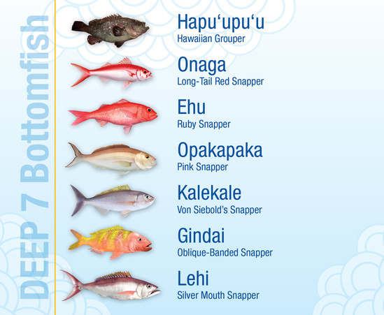 Graphic illustrating the Main Hawaiian Islands Deep 7 Bottomfish species (image coutesy of NOAA Fisheries).
This data archive contains the Modular Optical Underwater Survey System (MOUSS) stereo-video data from the NOAA Ship Oscar Elton Sette (Cruise SE-17-07) collected around the Main Hawaiian Islands (MHI) for the stock assessment of the Deep 7 Bottomfish species. The Deep 7 are the most culturally important and highly valued of the deep-water bottomfish species in Hawaii composed of six snapper species and one grouper species. Dates of the survey range from 2017-10-20 to 2017-11-03. Each video is fifteen minutes from the MOUSS touchdown on the seafloor as that is the literature based standard for Deep-7 species. The product also includes depth and temperature data collected using Temperature Depth Recorder (TDR) along with temporal and spatial information. The MOUSS video data are in the Audio Video Interleaved (AVI) file format. A metadata inventory CSV file is included for the cruise data.
- Cite as: MOUSS Stereo-Video Data for Hawaiian Deep 7 Bottomfish Surveys collected by the NOAA Ship Oscar Elton Sette (SE-17-07) from 2017-10-20 to 2017-11-03. [indicate subset used]. NOAA National Centers for Environmental Information. NCEI DSI 2050_01. [access date].
- NCEI DSI 2050_01
- gov.noaa.ncdc:C01651
C01651
| Download Data |
|
| Distribution Formats |
|
| Ordering Instructions | Contact NCEI for other distribution options and instructions. |
| Distributor | NOAA National Centers for Environmental Information
ncei.info@noaa.gov |
| Dataset Point of Contact | Customer Engagement Branch
NOAA National Centers for Environmental Information 1-828-271-4800 ncei.orders@noaa.gov |
| Time Period | 2017-10-20 to 2017-11-03 |
| Spatial Bounding Box Coordinates |
N: 22.3
S: 18.9
E: -154.8
W: -160.2
|
| Spatial Coverage Map | |
| General Documentation |
|
| Associated Resources |
|
| Publication Dates |
|
| Data Presentation Form | Digital video - digital video recording
|
| Dataset Progress Status | Complete - production of the data has been completed |
| Data Update Frequency | Not planned |
| Purpose | The purpose of the dataset is to operationally collect fishery-independent data to estimate stock abundance of economically and socio-culturally important Hawaiian bottomfish. The dataset is not only important for stock assessment, it is also socio-culturally and economically important in Hawaii. Thus, it is important to publish and archive the dataset so that other researchers, citizens, and scientists can utilize it for scientific or recreational purposes. |
| Dataset Citation |
|
| Cited Authors |
|
| Originators |
|
| Principal Investigators |
|
| Publishers |
|
| Theme keywords | Global Change Master Directory (GCMD) Science Keywords
|
| Data Center keywords | Global Change Master Directory (GCMD) Data Center Keywords
|
| Platform keywords | Global Change Master Directory (GCMD) Platform Keywords
|
| Instrument keywords | Global Change Master Directory (GCMD) Instrument Keywords
|
| Place keywords | Global Change Master Directory (GCMD) Location Keywords
|
| Use Constraints |
|
| Access Constraints |
|
| Fees |
|
| Lineage Statement | The data were produced by the NOAA Pacific Islands Fisheries Science Center (PIFSC) and were archived by the NOAA National Centers for Environmental Information (NCEI). |
| Processing Environment | MOUSS Audio Video Interleaved (.avi) videos were created from the Silicon Graphics Image (.sgi) images. |
| Processing Steps |
|
Last Modified: 2023-06-23
For questions about the information on this page, please email: ncei.info@noaa.gov