High Definition Geomagnetic Model 2020

browse graphic
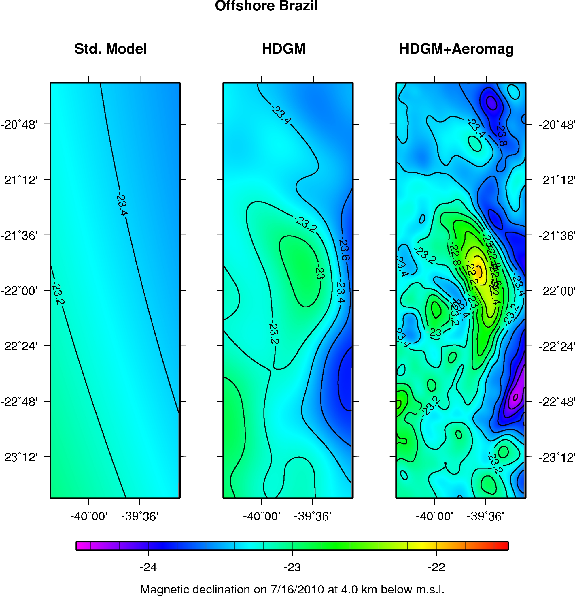
Declination contour maps that compare HDGM to global magnetic field models
The High Definition Geomagnetic Model (HDGM) is a global, high resolution model of the Earth's geomagnetic main and crustal field, providing magnetic field values (total field, dip, and declination) at any point above or below the Earth's surface. Well planners can use HDGM to compute magnetic reference values at any point, as well as easily integrate HDGM into their directional drilling software. HDGM is updated annually to correctly model secular changes in the geomagnetic field.
  • Cite as: NCEI Geomagnetic Modeling Team. 2019: High Definition Geomagnetic Model 2020. 1. NOAA National Centers for Environmental Information. Accessed [date].
  • NCEI Metadata ID: gov.noaa.ngdc:HDGM2020
gov.noaa.ngdc:HDGM2020
XML
Distribution Formats
    Ordering InstructionsContact NCEI for other distribution options and instructions.
    DistributorNOAA National Centers for Environmental Information
    ncei.info@noaa.gov
    Dataset Point of Contact NOAA National Centers for Environmental Information
    ncei.info@noaa.gov
    Dataset Point of Contact NCEI Geomagnetic Modeling Team
    NOAA National Centers for Environmental Information
    geomag.models@noaa.gov
    Time Period1900-01-01 to 2020-12-31
    Spatial Reference Systemurn:ogc:def:crs:EPSG::4326
    Spatial Bounding Box Coordinates
    N: 90
    S: -90
    E: 180
    W: -180
    Spatial Coverage Map
    General Documentation
    Publication Dates
    • publication: 2019-11-15
    Edition1
    Data Presentation FormmapDigital
    Dataset Progress StatusComplete - production of the data has been completed
    Historical archive - data has been stored in an offline storage facility
    Data Update Frequency As needed - Associated HDGM2020 software may be updated as improvements are created.
    PurposeThis data is available to the public for a wide variety of uses including scientific research and analysis.
    Use Limitations
    • Produced by the NOAA National Centers for Environmental Information. Not subject to copyright protection within the United States.
    Dataset Citation
    • Cite as: NCEI Geomagnetic Modeling Team. 2019: High Definition Geomagnetic Model 2020. 1. NOAA National Centers for Environmental Information. Accessed [date].
    Cited Authors
    • NCEI Geomagnetic Modeling Team
    Publishers
    • NOAA National Centers for Environmental Information
    Theme keywordsGlobal Change Master Directory (GCMD) Science Keywords
    • Earth Science > Solid Earth > Geomagnetism > Magnetic Field
    • Earth Science > Solid Earth > Geomagnetism > Magnetic Intensity
    • Earth Science > Solid Earth > Geomagnetism > Magnetic Declination
    • Earth Science > Solid Earth > Geomagnetism > Magnetic Inclination
    Data Center keywordsGlobal Change Master Directory (GCMD) Data Center Keywords
    • DOC/NOAA/NESDIS/NCEI > National Centers for Environmental Information, NESDIS, NOAA, U.S. Department of Commerce
    • DOC/NOAA/NESDIS/NGDC > National Geophysical Data Center, NESDIS, NOAA, U.S. Department of Commerce
    Place keywordsGlobal Change Master Directory (GCMD) Location Keywords
    • Geographic Region > Global
    Use Constraints
    • Use liability: NOAA and NCEI cannot provide any warranty as to the accuracy, reliability, or completeness of furnished data. Users assume responsibility to determine the usability of these data. The user is responsible for the results of any application of this data for other than its intended purpose.
    • The High Definition Geomagnetic Model is available to the public, but requires payment to recoup the cost of model development, custom software creation and testing, as well as customer service efforts. For more information please contact hdgm.support@noaa.gov
    Access Constraints
    • Distribution liability: NOAA and NCEI make no warranty, expressed or implied, regarding these data, nor does the fact of distribution constitute such a warranty. NOAA and NCEI cannot assume liability for any damages caused by any errors or omissions in these data. If appropriate, NCEI can only certify that the data it distributes are an authentic copy of the records that were accepted for inclusion in the NCEI archives.
    Other ConstraintsCite as: NCEI Geomagnetic Modeling Team. 2019: High Definition Geomagnetic Model 2020. 1. NOAA National Centers for Environmental Information. Accessed [date].
    Fees
    • The High Definition Geomagnetic Model is available to the public, but requires payment to recoup the cost of model development, custom software creation and testing, as well as customer service efforts. For more information please contact hdgm.support@noaa.gov
    Lineage information for: dataset
    Processor
    • NOAA National Centers for Environmental Information
    • NOAA National Centers for Environmental Information
    • NOAA National Centers for Environmental Information
    Processing Steps
    • The main component of the magnetic field generated by the Earth's core is calculated using data from a number of current and past satellite missions.
    • The component of the magnetic field generated by the Earth's lithosphere is calculated using data from a number of current and past models of the anomaly field of mineral distribution in the Earth's crust. These models are compiled from satellite, observatory, airborne, and marine observations of the Earth's magnetic field
    • The main component of the magnetic field generated by the Earth's lithosphere is converted into spherical harmonic coefficients in order to be combined with the magnetic field intensity and orientation of the Earth's core magnetic field.
    Source Datasets
    • Swarm Satellite Data
    • CHAMP Satellite Data
    • DMSP Satellite Data
    • CryoSat Satellite Data
    • Earth Magnetic Anomaly Grid 2 arc-minute resolution (EMAG2)
    Lineage information for: repository
    Processing Steps
    • 2015-04-22T00:00:00 - NOAA created the National Centers for Environmental Information (NCEI) by merging NOAA's National Climatic Data Center (NCDC), National Geophysical Data Center (NGDC), and National Oceanographic Data Center (NODC), including the National Coastal Data Development Center (NCDDC), per the Consolidated and Further Continuing Appropriations Act, 2015, Public Law 113-235. NCEI launched publicly on April 22, 2015.
    Last Modified: 2020-05-14
    For questions about the information on this page, please email: ncei.info@noaa.gov