Over 100 U.S. Climate Reference Network stations will record the meteorological impacts of today’s solar eclipse

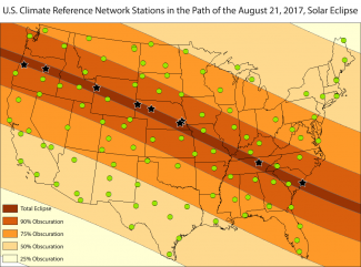
In just a few short hours, the Great American Eclipse will begin its journey across the country from Oregon to South Carolina. Millions have gathered in the approximately 70-mile-wide path of totality—where the moon will completely block the sun—to witness the marvelous few minutes when day will become night. And, NOAA’s unique network of climate observation stations will be witnessing this extraordinary astronomical event right alongside them.
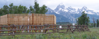
More than 100 U.S. Climate Reference Network, or USCRN, stations across the country stand ready to observe the meteorological impacts caused by the solar eclipse. Of these stations spanning the Lower 48, nine are located right in the eclipse’s path of totality—and six will be in totality for over two minutes.
Each of these stations will use high-quality instruments to measure temperature, solar radiation, and relative humidity before, during, and after the eclipse. The stations take observations in 5-minute increments, but only report these measurements to us once per hour. So, you won’t be able to see the effects in real time. You’ll be outside enjoying the eclipse—with the proper eye protection—anyway!
However, when the eclipse is over, or after you get home, the USCRN data will start coming in and should all be available by the evening for you to check out. Here are three ways to see the climate impacts at our stations:
-
Visit the Atmospheric Turbulence and Diffusion Division’s website
This site is a great resource for both before and after the eclipse. It provides access to a variety of data and information from NOAA, NASA, and other sources. The USCRN data will also be available on the site as they come in. -
Check out our interactive map
Created in partnership with the Cooperative Institute for Climate and Satellites–North Carolina (CICS-NC), this GIS-based map will show the hour-to-hour changes in conditions at all USCRN stations. And, it will display a graph time series of changes over the last 24 hours when you hover over a station location. -
Look for the USCRN’s complete report tomorrow
NCEI scientists plan to compile a complete report of the events at the nine USCRN stations experiencing totality. Come back tomorrow for this detailed analysis of the eclipse’s meteorological impacts at these locations.
U.S. Climate Reference Network Stations Within the Path of Totality
| Location | Elevation (feet) | Length of Totality (minutes : seconds) |
|---|---|---|
| Corvallis, Oregon | 312 | 1:00.1 |
| John Day, Oregon | 2,245 | 2:07.2 |
| Moose, Wyoming | 6,466 | 2:20.6 |
| Harrison, Nebraska | 4,406 | 2:23.7 |
| Whitman, Nebraska | 3,740 | 1:52.7 |
| Lincoln, Nebraska | 1,372 | 2:13.3 |
| Lincoln, Nebraska | 1,189 | 0:31.5 |
| Crossville, Tennessee | 1,913 | 2:33.2 |
| McClellanville, South Carolina | 9 | 2:28.9 |
What is the U.S. Climate Reference Network?
Since 2002, NCEI and NOAA’s Atmospheric Turbulence and Diffusion Division have together managed and operated the U.S. Climate Reference Network. The network’s mission is to monitor the climate across the United States in pristine locations for the next 50 years and provide user-driven information products based on these measurements.
The USCRN consists of a systematic and sustained network of stations with sites across the contiguous United States, Alaska, and Hawaii. These stations use high-quality instruments to measure air temperature, surface temperature, solar radiation, relative humidity, precipitation, soil conditions, and more.


