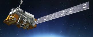
NOAA’s newest environmental satellite, JPSS-1, the Joint Polar Satellite System, heads into polar orbit this month equipped with several state-of-the-art instruments. Among them are three key instruments for weather forecasting:
- Visible Infrared Imaging Radiometer Suite (VIIRS)
- Advanced Technology Microwave Sounder (ATMS)
- Cross-Track Infrared Sounder (CrIS)
“These instruments are considered essential to fulfilling ‘key performance parameters,’ which means that without the data these instruments provide, NOAA’s National Weather Service can’t do its job in creating the forecast,” says Mitch Goldberg, a NOAA scientist working with the Joint Polar Satellite System (JPSS) program.
Weather-Related Instruments on JPSS-1
| Instrument | Capability |
|---|---|
| VIIRS Radiometer | Takes visible and infrared imagery and global observations of land, atmosphere, cryosphere, and the ocean |
| ATMS Microwave Sounder | Collects observations of temperature and moisture with 3-D ability |
| CrIS Infrared Sounder | Works with ATMS to collect temperature and moisture data as well as information about greenhouse gases |
The instruments give NOAA tools to forecast the trajectory of storms, such as hurricanes, and provide more accurate five- to seven-day outlooks that can assist with emergency preparations and responses.
In addition to the three weather instruments, JPSS-1 will also carry two other instruments: the Ozone Mapping and Profiler Suite (OMPS) and the Clouds and the Earth's Radiant Energy System (CERES). OMPS will track the health of the ozone layer and measure the concentration of ozone in Earth's atmosphere, while CERES will measure reflected sunlight and thermal radiation emitted by Earth.
NCEI will steward and service JPSS-1’s data for users in cooperation with the NOAA Comprehensive Large Array-Data Stewardship System (CLASS), which will archive the data under the auspices of the NOAA Office of Satellite and Production Operations.
JPSS-1 Satellite Advancements
In coordination with NASA, JPSS-1 is scheduled to launch on November 10, 2017, from Vandenberg Air Force Base, California, and join a fleet of NOAA environmental satellites already in orbit. Eighty-five percent of the data that feed weather forecast models comes from polar-orbiting satellites, positioned approximately 520 miles above Earth, circling from pole to pole. Currently, NOAA operates four polar-orbiting satellites: NOAA 15, 18, and 19, and Suomi NPP. JPSS-1 will be renamed NOAA-20 once in orbit.
JPSS-1 will continue the success of its polar-orbiting predecessors. Its primary instruments are improved versions of those on Suomi NPP, which initially began as a research satellite. JPSS-1 will orbit about 50 minutes ahead of Suomi NPP but in the same plane. This allows an important overlap in observational coverage of the globe. JPSS-1’s life expectancy is also longer than Suomi NPP, which is nearing retirement.
Other improvements to the satellite itself include features to reduce spacecraft vibrations after maneuvers, more modern and efficient cells on the solar array, and additional blanketing on the spacecraft to protect it from orbital debris.
JPSS-1 Instruments Track More Than Weather
Besides contributions to weather monitoring and forecasting, JPSS-1’s instruments are designed for more functions, such as tracking wildfires across the country. Its ability to capture visible imagery of Earth’s surface using moonlight will effectively monitor fires as well as the movement of sea ice at night and clouds during the Arctic and Antarctic winters.
The satellite will also detect lighting from cities, towns, villages, and fishing boats. Nighttime lights data can be found from NCEI’s Earth Observation Group. Other data from JPSS-1 will include ocean color imagery, vegetation health observations, and sea surface temperature data.
Some instrument data will be available roughly three to six months after launch, while other products will require more time to validate.


