

NOAA and its partners have released the latest Regional Climate Impacts and Outlooks, which recap spring conditions and provide insight into what to expect this summer. The summaries include the addition of spring conditions for the Chesapeake Bay/Mid-Atlantic Region. NOAA’s Mid-Atlantic RISA Team (MARISA) created this outlook in partnership with NOAA’s Regional Climate Services Program to inform the public about recent climate impacts in that region.
Spring Temperature Recap
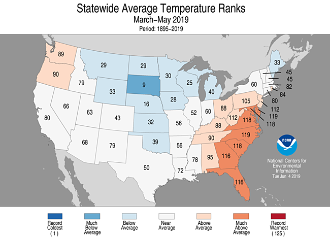
Despite a below-normal U.S. temperature for May, meteorological spring (March–May), for the country as a whole, had a near-average temperature. The seasonally averaged temperature for the contiguous United States was 50.9°F, 0.1°F below average and ranked in the middle third of the record. Seven states across the Southeast had one of their 10 warmest March–May periods on record. Conversely, below-average temperatures were observed from the northern Rockies to the central Plains and into the Great Lakes and part of New England. South Dakota had its ninth coldest spring on record.
Summer Temperature Outlook
The July–September 2019 temperature outlook indicates that above-normal seasonal mean temperatures are most likely for the western third of the contiguous United States and all of Alaska. The highest odds for above normal temperatures are across Washington state and the Alaska Panhandle. Above-normal temperatures are also favored for southern Texas, the Gulf Coast states, and east of the Appalachian Mountains. Below-normal temperatures are the most likely category from the Central and Southern Plains to the Upper Great Lakes.
Spring Precipitation Recap and Summer Outlook
Continuing a wet trend, both the spring and year-to-date precipitation totals for the contiguous U.S. were well-above average. The spring precipitation total was 9.85 inches, 1.91 inches above average and the sixth wettest spring on record. Above- to much-above-average spring precipitation was observed across most of the contiguous U.S. from California to New England. Kansas had its wettest March–May on record while six additional states had a top five wettest spring.
Above-normal precipitation is forecast for a large region of the contiguous U.S. from the interior West to the Mississippi Valley.
Impacts and Outlooks for Your Region
Find more details for your region in the most recent climate impacts and outlooks summaries:
- Alaska and Northwestern Canada Region
- Chesapeake Bay/Mid-Atlantic Region
- Great Lakes Region
- Gulf of Maine Region
- Midwest Region
- Missouri River Basin Region
- Northeast Region
- Pacific Region
- Southeast Region
- Southern Region
- Western Region
Creating The Quarterly Summaries
NOAA’s Regional Climate Services lead the production of these quarterly summaries of climate impacts and outlooks for various regions of the United States as well as parts of Canada along the border. This effort, which began in 2012, now includes as many as 11 unique regional products, all produced collaboratively with partner organizations.
You can access all of the summaries as well as additional reports and assessments through the U.S. Drought Portal Reports web page at Drought.gov.


