
February brought a warm and wet end to winter for the United States

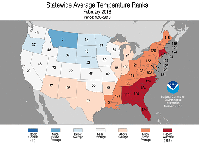
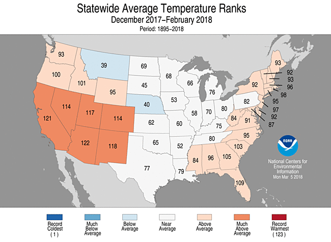
During February, the average contiguous U.S. temperature was 35.4°F, 1.6°F above the 20th century average. This ranked among the warmest third of the 124-year period of record. Abnormally warm conditions spanned the East and parts of the Southwest, with below-average temperatures in the Northern Rockies and Northern to Central Plains. The winter (December–February) average contiguous U.S. temperature was 34.0°F, 1.7°F above average, also ranking among the warmest third of the record. Much of the East Coast and West had a warmer-than-average winter.
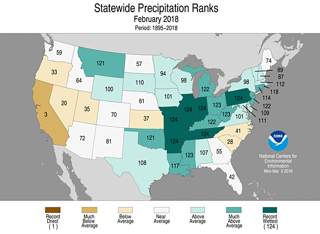
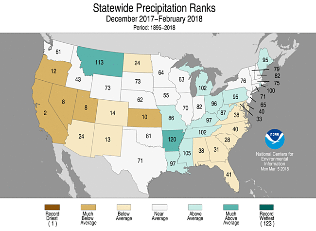
The February precipitation total for the contiguous U.S. was 2.84 inches, 0.71 inch above average. This was the sixth highest February precipitation total on record for the nation and the highest since 1998. Record precipitation fell over a large part of the interior U.S., with parts of the West, Central Plains, and Southeast being drier than average. The winter precipitation total was 6.26 inches, 0.53 inch below average, and ranked in the driest third of the record. The winter season was marked by regional precipitation extremes—large areas of the West, Plains, and Southeast were drier than average, while the Northern Rockies, Midwest, and Lower-Mississippi Valley were wetter than average.

This monthly summary from NOAA’s National Centers for Environmental Information is part of the suite of climate services NOAA provides to government, business, academia, and the public to support informed decision-making.
See all February U.S. temperature and precipitation maps.
For additional supplemental information, see:
- Winter Snowfall Departures from Average
- Historically Extreme Spring Temperature and Precipitation Maps
- County Temperature and Precipitation Maps
February Temperature

-
Much-above-average temperatures were observed across the Deep South, Midwest, and the East Coast. Eight states in the Southeast and southern New England were record warm and 15 additional states in the East had a top 10 warm February. A significant warm spell impacted the East in late February, with more than 650 all-time monthly temperature records broken or tied.
-
Below-average temperatures were observed in the Northwest, Northern Rockies, and Northern Plains. Montana had its sixth coldest February on record with a monthly temperature 9.7°F below average. This was the coldest February for the state since 1989.
-
The Alaska February temperature was 13.1°F, 8.3°F above the long-term average. This was the 12th warmest February in the 94-year period of record for the state. Western, central, and northern Alaska were much warmer than average, with below-average temperatures in the panhandle. St. Paul had its warmest February on record, and Barrow and Cold Bay had their second warmest. Juneau had its coldest February since 1994.
February Precipitation

-
Record-setting precipitation was observed across the mid- and lower-Mississippi Valley, the Midwest, and Northern Rockies. Six states were record wet, and 10 additional states had a top 10 monthly precipitation total. The heavy precipitation in the East mostly fell during a one-week period, when a stalled frontal system dropped torrential rainfall, causing part of the Ohio River to crest at the highest level in more than two decades. At least six fatalities were blamed on the flooding.
-
In the Northern Rockies, the heavy precipitation and below-average temperatures resulted in record snowpack for some locations.
-
-
Below-average precipitation was observed across parts of the Southeast, Southern Plains, and West. California had its third driest February on record with 13.5 percent of average precipitation. This was the driest February for California since 1967. The below-average precipitation in the Southwest was associated with much-below-average snowpack from the Sierra Nevada Mountains to Southern Rockies.
-
According to the February 27 U.S. Drought Monitor report, 31.3 percent of the contiguous U.S. was in drought, down from 38.4 percent at the end of January. Drought conditions improved in the Northern High Plains, Central Plains, and Mid-Atlantic, and the South to Mid-Mississippi Valley had dramatic drought improvement. Drought conditions worsened across parts of the West and the Southern High Plains.
Winter Temperature

-
Above-average winter temperatures were observed across much of the West and along the East Coast. Six states in the Southwest had winter temperatures that were much above average, with some locations being record warm. Cooler-than-average winter temperatures were observed in parts of the Northern High Plains to Central Plains. No state was record warm or record cold.
-
The Alaska December–February temperature was 12.9°F, 9.3°F above the long-term average, the fourth warmest on record for the state. Much-above-average temperatures spanned the state, with record warmth along the North Slope. Barrow and St. Paul each were record warm, and Bethel, McGrath, Kotzebue, and Cold Bay all had a top three warm month.
Winter Precipitation

-
Below-average precipitation was observed across much of the West and parts of the Plains and Southeast. Three states in the West and one in the Plains had a top 10 dry winter season. Parts of the Southern High Plains were record dry. California had its second driest winter on record, with 33.7 percent of average precipitation. This was the driest winter for the state since 1976/1977. Despite the below-average winter precipitation in the state, the majority of reservoirs are at near-average capacity for the time of year.
-
Above-average precipitation fell across the Northern Rockies, Lower Mississippi Valley, Midwest, and Northeast. After having its driest autumn on record, Arkansas had its fourth wettest winter on record, with 160 percent of average precipitation. This was the wettest winter for Arkansas since 1949.


