Nor’easter brought blizzard conditions, significant snowfall to Northeast

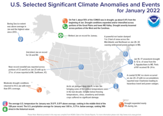
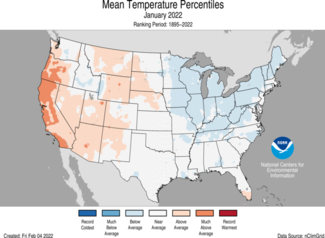
During January, the average contiguous U.S. temperature was 31.0°F, 0.9°F above the 20th-century average, ranking in the middle third of the 128-year record and was the coolest January since 2014.
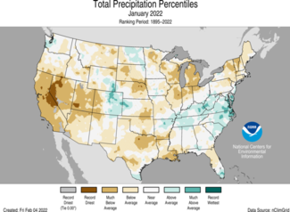
The January precipitation total for the contiguous U.S. was 1.60 inches, 0.71 inch below average, and tied with 2009 for 14th driest in the 128-year period of record. This was the driest January since 2014.
A type of nor’easter known as a bomb cyclone, or a rapidly intensifying low pressure system, developed over the Atlantic Ocean along the East Coast on January 28-30 and brought 1 to 2 feet of snow and blizzard conditions along the coastline from Delaware to Maine. This event was classified as a Category 1 snowstorm, considered “Notable” on the Regional Snowfall Index (RSI) scale. On January 29, Boston tied its greatest 1-day snowfall total — 23.6 inches.
This monthly summary from NOAA National Centers for Environmental Information is part of the suite of climate services NOAA provides to government, business, academia and the public to support informed decision-making.
January
Temperature
- Temperatures were above average across much of the West and parts of the northern Plains. California had its ninth-warmest January on record. Temperatures were below average from the Midwest and Tennessee Valley to the Northeast and were associated with a persistent trough of low pressure across the region.
- The Alaska average January temperature was 3.9°F, 1.7°F above the long-term mean, ranking in the middle third of the 98-year record. Temperatures across the state were fairly mild during January with above-average temperatures observed across portions of Cook Inlet and the Southeast Interior regions.
- Mild January temperatures contributed to a monthly average Bering Sea Ice extent that was double the record-low value set in 2018 and the highest value since 2013.
Precipitation
- Precipitation was above average across portions of the Colorado High Plains, northern Plains, Tennessee Valley and Mid-Atlantic. Precipitation was below average across most of the Lower 48. Regions with below-average precipitation included much of the West, High Plains, Deep South, Great Lakes and Northeast. Nevada and California each had their second-driest January, and Utah experienced its third driest January on record.
- Several significant snow events occurred throughout the month, including the January 4 event that brought a blanket of snow from Arkansas to Delaware and stranded motorists for as long as 24 hours on I-95 in Virginia. A snow event on January 16-17 brought significant snowfall from the southern Appalachians to Maine with portions of New York state reporting 18-24 inches of snow. The nor’easter, which brought heavy snowfall to portions of the Mid-Atlantic and Northeast on January 28-30, intensified at nearly double the rate of a classic bomb cyclone, dropping 35 millibars in an 18-hour period. At least 100,000 people were without power during this storm.
- Alaska ranked in the wettest third of the historical record for January. The North Slope, Southeast Interior, Northeast Gulf and Panhandle regions were wetter than average while the Aleutians received below-average precipitation during January.
- According to the February 1 U.S. Drought Monitor report, approximately 55.2 percent of the contiguous U.S. was in drought, which is up about 0.4 percent from the beginning of January. Drought conditions expanded and/or intensified across portions of the Great Plains and lower Mississippi Valley. Drought severity lessened across portions of the West and the Carolinas. Moderate drought conditions returned to Hawaii in January with more than 81 percent coverage across the islands, while drought expanded nearly 11 percent across Puerto Rico during January.
For more detailed climate information, check out our comprehensive January 2022 U.S. Climate report scheduled for release on February 11, 2022.

