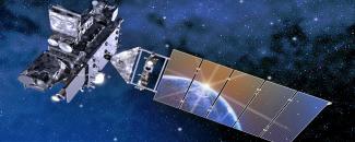
When NOAA’s first new GOES-R weather satellite—now known as GOES-16—launched into space on November 19, 2016, NCEI scientists didn’t have much time to celebrate—their work had just begun. NCEI’s Solar Terrestrial Physics (STP) scientists go far beyond data archiving and stewardship when it comes to GOES-R space weather instruments and products.
The Geostationary Operational Environmental Satellite (GOES) – R Series is the nation’s most advanced fleet of geostationary weather satellites. The GOES-R Series significantly improves the detection and observation of environmental phenomena that directly affect public safety, protection of property, and our nation’s economic health and prosperity.
The satellites provide advanced imaging with increased spatial resolution and faster coverage for more accurate forecasts, real-time mapping of lightning activity, and improved monitoring of solar activity and space weather.
The GOES-R Series is a four-satellite program (GOES-R/S/T/U) that will extend the availability of the operational GOES satellite system through 2036. GOES-16 is the first in this series.
Making Sure Everything “GOES” Smoothly
Before the GOES-16 satellite launch could take place, instruments on the satellite had to be calibrated and validated on the ground. The GOES-16 satellite has four space weather instruments: the magnetometer, SEISS particle detector, SUVI solar imager, and EXIS X-ray and extreme ultraviolet sensor. The pre- and post-launch performance of these instruments are compared through a process called calibration and validation or “Cal/Val.”
For each of these instruments, dedicated STP scientists analyze the data collected during Cal/Val to identify potential problems. Issues can arise from any number of causes. In some cases, incorrect values can be reported due to incorrect calibration factors. In other cases, faulty algorithms can cause incorrect calculations. For example, exceptionally high irradiance values can cause software to malfunction.
Another issue STP scientists work on involves time stamps. Much like the time stamps on pictures taken with your camera, GOES data is marked with the time the data were collected. Making sure the time stamp is correct is essential information for scientists studying space weather. STP scientists were responsible for alerting engineers with the GOES program to resolve any issues associated with time stamps. Changes resulting from this testing have dramatically increased the quality of the data received.
Useful Tools
A major responsibility STP scientists have is to create what are known as space weather “products.” These products can be used by others to study and improve space weather forecasting. Many of the products developed by STP scientists are used by forecasters in the Space Weather Prediction Center (SWPC).
When STP scientists aren’t busy validating the GOES data, they can frequently be found coding the algorithms to create and improve these products. These algorithms are then added into larger software systems that STP’s system engineer and IT team designed and created.
This system, called SPADES, monitors the incoming GOES data and produces products at the correct interval. Additionally, it monitors the data and reports issues. Though SPADES is currently a demonstration system, the National Weather Service is adopting most of its key aspects as it creates an operational version that SWPC forecasters will use.
Looking Ahead
NCEI’s deep involvement in validating and creating GOES-R space weather products has had synergistic effects on how it archives and stewards these data. Because STP scientists are intimately acquainted with the issues affecting early GOES-R data, they know how to correct these issues. They are also making data more user-friendly by taking steps such as reformatting thousands of smaller files into a single day file.
For the early months of GOES lifetime, the raw data will be reprocessed, so that the new versions are much more accurate than those that were originally produced. This will effectively extend the lifetime of the mission by a year or more. Also, because STP scientists have worked closely with the community that uses their products, they know what further enhancements and formatting changes can be made to benefit users. These enhanced products will be archived alongside the original data files, which will benefit users and science for generations to come.


