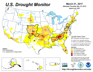
According to the March 21, 2017, U.S. Drought Monitor, moderate to extreme drought covers 16.0% of the contiguous United States, an increase from last week’s 15.2%. Areas in extreme drought decreased from around 0.5% last week to 0.4%. No areas were in exceptional drought, the worst category.
A strong low pressure system dropped above-normal precipitation across much of the Northeast at the beginning of this U.S. Drought Monitor week, with cold and dry Canadian air behind the low giving the eastern third of the contiguous United States a cooler-than-normal week and keeping moisture out of much of the Southeast. Meanwhile, upper-level ridging brought warmer- and drier-than-normal weather to much of the Southwest and Great Plains eastward to the Mississippi River. Weather systems in the jet stream flow moved over the top of the ridge, bringing precipitation to the Pacific Northwest and parts of the northern tier states to the Ohio Valley.
The full U.S. Drought Monitor weekly update is available from Drought.gov.
In addition to Drought.gov, you can find further information on the current drought as well as on this week’s Drought Monitor update at the National Drought Mitigation Center.
The most recent U.S. Drought Outlook is available from NOAA’s Climate Prediction Center and the U.S. Department of Agriculture’s World Agriculture Outlook Board provides information about the drought’s influence on crops and livestock.
For additional drought information, follow #DroughtMonitor on Facebook and Twitter.


