U.S. Drought Highlights:

- On the national scale, severe to extreme drought affected about 18 percent of the contiguous United States as of the end of May 2004
- moderate to extreme drought affected about 33 percent of the contiguous U.S.
- May was warmer than normal and dry across the Southeast, southern and central Plains, and parts of the West, resulting in a slight increase in the national percentage drought area
- Above-normal rainfall brought improving conditions to the Upper Midwest (April - May) and short-term relief to the drought areas of the Pacific Northwest
- Long-term moisture deficits (last 9 to 24 to 60 months) persisted across parts of the Great Plains, parts of the Southeast, and most of the West
Please Note: The data presented in this drought report are preliminary. Ranks, anomalies, and percent areas may change as more complete data are received and processed.
National Overview
On the national scale,
- severe to extreme drought affected about 18 percent of the contiguous United States as of the end of May 2004, an increase of about 3 percent compared to last month
- about 33 percent of the contiguous U.S. fell in the moderate to extreme drought categories (based on the Palmer Drought Index) at the end of May
- on a broad scale, the last two decades were characterized by unusual wetness with short periods of extensive droughts, whereas the 1930s and 1950s were characterized by prolonged periods of extensive droughts with little wetness
- about 7 percent of the contiguous U.S. fell in the severely to extremely wet categories at the end of May
- a file containing the national monthly percent area severely dry and wet from 1900 to present is available
- historical temperature, precipitation, and Palmer drought data from 1895 to present for climate divisions, states, and regions in the contiguous U.S. are available at the Climate Division: Temperature-Precipitation-Drought Data page in files having names that start with "drd964x" and ending with "txt" (without the quotes).
Regional Overview
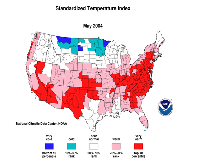
May was warmer than normal and dry across the Southeast, southern and central Plains, and parts of the West. Above-normal rainfall brought improving conditions to the Upper Midwest (April vs. May) and short-term relief to the drought areas of the Pacific Northwest. Much of Alaska was wetter than normal, but drier than normal conditions prevailed at the primary stations along the southern coastal band and southeastern panhandle. The rainfall pattern in Hawaii was mixed. The primary stations in Puerto Rico were generally wetter than normal, but a few stations at the western end of the island were drier than normal for the 4 weeks to 8 weeks ending in May.
Dry conditions have persisted during most of the last 8 months across much of the Southeast, giving the region the seventh driest spring (March-May) and ninth driest January-May in the 110-year record. This sharply contrasts with the previous 13 months which were predominantly wet, and marks a return to the dry conditions which prevailed for much of the preceding four years. The recent dryness resulted in the third driest May for the Southwest region and sixth driest spring (March-May) for the West region.
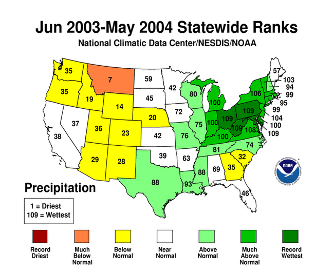
This month's short-term dryness compounded the long-term moisture deficits (last 9 to 24 to 36 to 60 months) in many areas. The West North Central region had the 11th driest June-May on record this year, marking the fifth consecutive such 12-month period with below-normal precipitation.
Some regional highlights:
- Several states had the tenth driest, or drier, month or season for:
- May (Arizona-2nd, Oklahoma-2nd, Colorado-4th, New Mexico-8th, Florida-8th)
- spring (March-May) (Georgia-2nd, Florida-4th, South Carolina-4th, California-5th)
- January-May (Maine-6th, North Carolina-8th, South Carolina-9th)
- December-May (Georgia-5th, South Carolina-10th)
- November-May (South Carolina-8th)
- August-May (South Carolina-7th)
- July-May (Wyoming-9th)
- June-May (Montana-7th)
- Soil moisture conditions:
- End-of-month soil moisture conditions were much drier than normal in the Southeast and parts of the Great Plains and West, based on model computations.
- USDA topsoil moisture observations were dry to very dry (both observed and compared to recent [5-year and 10-year] climatologies) in states in the Southeast, Great Plains, and Rocky Mountains.
- According to end-of-May USDA reports, more than 30 percent of the pasture and range land was in poor or very poor condition in the Rocky Mountain states and adjoining central and northern Plains states, and in California, Florida, and Georgia. Several other states had poor or very poor condition percentages that were higher than seasonal norms.
- Much of the western U.S. has experienced dry conditions for the last five years. Continued dryness this month has exacerbated drought conditions across parts of the West.
- High elevation SNOTEL station reports reveal a much below-average mountain snowpack. Western streams and reservoirs depend on water from spring snowmelt, but the snowpack has been less extensive and melting earlier than normal in recent years.
- Reservoirs in most of the western states were still low or depleted.
- Streamflow levels were below seasonal norms, especially in the northern Rockies, both as computed by models and based on USGS observations.
- The percent area of the western U.S. (Rockies westward) experiencing moderate to extreme drought (as defined by the Palmer Drought Index) increased during May to about 67%. While this is not near record historical levels, it is still comparable to the major droughts of the 20th Century.
Paleoclimatic Perspective
Western Nebraska has been experiencing drought conditions since the summer of 2000. In July 2002, the Palmer Drought Severity Index (PDSI) for the Panhandle (climate division 1) reached the most severe value of the instrumental record. Extensive reliable instrumental records go back only about 100 years, but tree rings are a form of paleoclimatic data that can reliably extend the climate record back several more centuries.
Ponderosa pine tree growth in western Nebraska is related to soil moisture conditions in the spring. Because of this relationship, variations in tree-ring widths can be used as a proxy for May drought as measured by the PDSI. A comparison between the instrumental record of Nebraska Division 1 (the Panhandle of western Nebraska) PDSI (red line) and a tree-ring chronology from a site called Canyon Road (blue line) for 1900-1997 shows a correspondence between low growth and drought particularly after about 1920. The match between the two series for the wet years is not as good, so this record is best used as a proxy for dry conditions (small graph - large graph). Both the tree-ring reconstruction and the Panhandle PDSI time series have been converted to standardized z-scores using their respective means and standard deviations over the 1931-1990 PDSI calibration period.


The tree-ring record can be used to place 20th and 21st century droughts into a long term context. In the graph to the right above, annual tree-ring reconstructed values are plotted against the May PDSI from each year. The Canyon Road chronology extends from 1489 to 1997 (blue line), while the instrumental PDSI record (red line) extends from 1900 to 2004. The 2000-2004 drought has the most severe PDSI values in the instrumental record, followed by the 1930s drought which is the most persistent drought of the last 100 years. The tree-ring record suggests that many single years exceed the severity of these years. The ring for 1934 was the smallest ring (driest spring) of the 20th century, but it was only the 25th smallest ring in the 509-year record. The smallest growth year in this longer time span is 1824, indicating severe drought conditions. Other very dry years were 1496, 1685, and 1579. Even when considering the 1930s and the recent droughts, the 20th and 21st centuries, in the context of the full tree-ring record, appear to be a period of moderate drought extremes. Several periods of time in past centuries are notable for a high occurrence of extreme drought years, including periods from about 1848-1880 and 1625-1685.
Resources:
More information on the Canyon Road tree-ring chronology can be found in this publication:
- Woodhouse, C.A. and P.M. Brown, 2001. "Tree-ring evidence for Great Plains drought." Tree-Ring Research, 57, 89-103.
Additional Resources:
The Canyon Road tree-ring chronology is available from the International Tree-Ring Data Bank: https://www.ngdc.noaa.gov/paleo/treering.html
Additional paleoclimatic information can be found at the NOAA Paleoclimatology Program web site: http://www.ncdc.noaa.gov/paleo/paleo.html