| Contents Of This Report: |
 |

|

|
|
|
March experienced a
persistent storm track that locked in heavy
precipitation from central Texas to the Ohio Valley and into
the Northeast. Rainfall during the middle of the month improved
drought conditions in much of the Southeast (March 4 USDM
versus April 1 USDM),
but it was not enough to erase long-term
deficits and eliminate the hydrologic
drought. Unusually
dry conditions affected much of the West, Great Plains, and
Great Lakes regions. March was the second dry month in a row for much of Puerto Rico, the Hawaiian Islands, and interior and south central Alaska. Mountain snowpack continued at below average levels in northeast Alaska, while streamflow averaged below normal in Puerto Rico and most of the Hawaiian Islands. A dry February, combined with the March dryness, lowered the year-to-date precipitation anomalies (more detailed maps for Puerto Rico, Hawaii, and Alaska).  The cold half-year (October-March) is the dry season in the northern Plains. Nevertheless, this winter has been much drier than normal for much of the area, with North Dakota experiencing the driest December-March and November-March in the 114-year record. Minnesota had the second driest November-March, Nebraska had the seventh driest January-March and tenth driest November-March, and South Dakota had the 12th driest November-March. Both surface soil moisture (Mosaic model, Noah model) and deeper soil moisture (Mosaic model, Noah model) were drier than normal in the northern Plains. 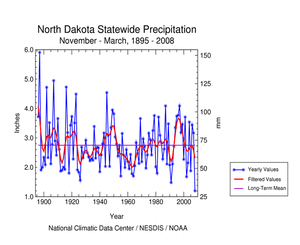 |
According to the USDM,
about one-third of
the West was experiencing moderate to severe drought as of
April 1, which is about the same as last
month, but the percent area in severe drought has decreased.
The percent area in moderate to extreme drought based on the Palmer
Drought Index was about
45%, which is an increase compared to last month due to the
very
dry March in the Southwest (Palmer Drought Index map for
March
versus February). The Palmer conditions this winter are a considerable improvement from the extensive area of last summer and most of the last 20 years. During the winter of 2007-2008, much of the West received average to above average rain and snow, and mountain snowpack and snow water equivalent remained near to above average in most areas at the end of the month. If these conditions continue, spring runoff from the above average snowpack in the West is expected to be beneficial in the drought areas and help fill reservoirs that still averaged below-normal. Drought conditions over the Southeast continued to improve, with USDM statistics showing moderate to exceptional drought covering about 59% of the region by the end of March compared to about 66% near the beginning of the month. The extreme drought area contracted and exceptional drought disappeared. But the drought was far from over. While beneficial rains fell across North Carolina during March and early April, replenishing reservoirs, much of the state was drier than normal for March and many previous months. The long-term deficits were so severe that 2007-2008 still ranked, statewide, as the driest on record for May-March and April-March, groundwater levels remained low, and deeper soil moisture conditions remained dry. The continuing hydrological impacts prompted Governor Easley to ask local officials to continue their aggressive water conservation efforts since the drought was not over and a hot, dry summer was still possible. The persistent dryness in the southern Plains has depleted soil moisture and ravaged pastures, especially in south and west Texas. Voluntary or mandatory water restrictions continued in many Southeast communities. Soil moisture was most severely affected in the mid-Atlantic to southern Plains, with dry conditions also apparent in parts of Florida, the northern Plains, western Great Lakes, and Far West. Streamflow (both modeled and observed) averaged below normal across the Southeast, mid-Atlantic, northern Great Plains, and parts of the West. Groundwater measurements remained low in parts of the mid-Atlantic, Southeast, Great Plains, and Southwest. A more detailed drought discussion can be found below. |
|
|
|
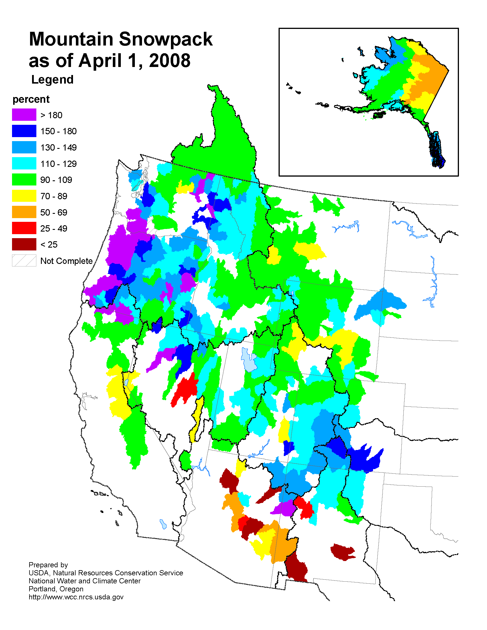
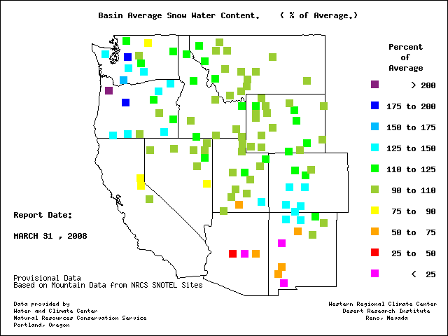
According to the Southeast Regional Climate Center, rain in the middle of the month led to the removal of the USDM D4 drought classification in both North and South Carolina, the first time they have been D4-free since August 2007. By month's end, the entire region was out of the D4 category. However, only south Georgia and north Florida were not abnormally dry or in some form of drought, ranging from abnormally dry in Puerto Rico to extreme drought in portions of the northern states. A series of traveling storms dropped 5 to 10 inches (127-254 mm) of rain in some areas, helping to fill reservoirs and return some moisture to the soil. However, much of the area had near average rainfall for the month, and some were 1-3 inches (25-76 mm) below average, such that groundwater recharge was relatively small. As noted by the Southern Regional Climate Center, March precipitation totals in the Southern Region were quite variable, with approximately half the region experiencing above normal totals, and the other half experiencing below normal monthly totals. A large swath of positive precipitation anomalies were observed through the central portion of the region. Elsewhere, precipitation totals were generally below normal, with the exception of eastern and central Tennessee, where precipitation was generally within 15% of normal for the month. In Louisiana, conditions were quite dry in the northeastern and southeastern portions of the state, with monthly totals ranging from 30-60% of normal. Similar conditions were also observed throughout Mississippi. Conditions were slightly drier in the panhandles of Texas and Oklahoma, were monthly totals ranged from 0-50% of normal. Drought conditions were observed in four of the six states within the Southern Region. In Texas, 44% of the state was experiencing moderate drought conditions or worse, with about a quarter of that area classified as severe drought or worse. A small patch of extreme drought was present in the south central counties of the state; however, it encompassed only approximate 4% of the state's area. All drought conditions within Texas were concentrated in the western half of the state, where precipitation was generally below normal for the month. In Oklahoma, a small area of moderate drought was present in the three panhandle counties. Larger areas of abnormally dry conditions were observed in southern Louisiana and southern Mississippi. In the case of the latter, there was a small area of moderate drought in northeastern Mississippi. In Tennessee, drought continued to plague the eastern half of the state. Although only approximately 15% of the state was experiencing extreme drought conditions, approximately half the state was experiencing moderate to severe drought. According to preliminary USDA reports, as of March 30, 47% of the winter wheat crop in Texas was rated poor to very poor, 32% in Colorado, 21% in Oklahoma, and 20% in Kansas. As explained by the Midwest Regional Climate Center, precipitation across the northwestern half of the Midwest was well below normal in March, with the exception of northwestern Minnesota. Northern Iowa into northeastern Minnesota, the northern two-thirds of Wisconsin, and eastern Lower Michigan received less than half the normal March precipitation. Precipitation was two to three times normal across the southern half of Missouri, southern Illinois, southern Indiana, northern Kentucky, and Ohio. March snowfall was above normal across western Minnesota, northern Illinois and southern Wisconsin, and from southern Missouri northeast through the Ohio Valley. As noted by the High Plains Regional Climate Center, dry weather persisted for much of North Dakota, central South Dakota and Nebraska, and western Kansas, with less than 50% of normal precipitation for most locations. Drought conditions continued over areas of western North Dakota and western South Dakota, with a USDM categorization change from D2 to D3 during the month of March, as the area received only 10-50% of normal total precipitation. Southwest Nebraska/northwest Kansas also saw a USDM categorization change from D0 to D1 during this time period. Portions of North Dakota experienced categorical improvement. As summarized by the Western Regional Climate Center, except for isolated pockets in the northern Rockies, precipitation tended to run below normal for the entire region, with some places in the Southwest measuring no rain at all for the month. The pattern in March bore a greater resemblance to a typical La Niña, with especially dry conditions across Utah, Arizona, Nevada, and California. March 2008 was extremely dry in much of California, tying the driest March in 68 years at Sacramento airport with 0.05 inches (which is a departure from average of -2.75 inches). The Sierra Nevada snow pack dropped to about 95% of normal as of the important April 1st survey, with only 17 inches (43 cm) of snow falling near Donner Summit for the month. In general, however, the western snow pack was among the healthiest in more than a decade, with most locations at least near average, a few locations showing 80-90% of average, and some locations, such as the San Juan Mountains of southwest Colorado, well above average. The Water Year to date (October 2007 through March 2008) has not shown a typical La Niña precipitation pattern (usually dry in the Southwest and wet in the Northwest), but rather shows a number of large pockets of above average and below average precipitation, with parts of the interior West being more favored. It is quite interesting that snow pack percentages have been close to average in many places, but precipitation percentages have been 10-15 percentage points lower, indicative of a larger than usual ratio of snow to rain. This is also reflected in the temperature pattern for the winter, with cooler than usual conditions in many locations. The cooler weather has helped both create and preserve a greater snow pack than in many recent winters. National Weather Service reports indicated that record-dry March rainfall was reported at Lihue and Kahului, Hawaii. Lihue had 0.19 inch for March 2008 compared to a March normal of 3.58 inches and the previous record low of 0.30 inch in March 1957. For Kahului, March 2008 had 0.01 inch compared to the normal of 2.35 inches and previous record low of 0.09 inch in 1957. As noted by the Northeast Regional Climate Center, precipitation totals in March averaged 138% of normal, making this month the second consecutive month with above normal precipitation. Delaware and Maryland were the dry states, with 70% and 78% of the normal March precipitation, respectively. According to the USDM, southeastern Maryland and extreme southern Delaware were still under severe drought conditions at month's end. In stark contrast, the Palmer Drought Severity Index for the period ending March 29, 2008 indicated unusually moist to extremely moist conditions for New England, New York, Pennsylvania, western West Virginia and northern New Jersey. |
|
| A detailed review of
drought and moisture conditions is available for all contiguous U.S.
states, the nine standard regions, and
the nation (contiguous U.S.): STATES: REGIONS:

|
|