| Contents Of This Report: |
 |

|

|
|
|
A shift in the weather
pattern occurred during April, with much of the eastern Great Lakes
and adjoining Northeast having below-normal
precipitation. The dryness, combined with periods of much
warmer-than-normal temperatures, created a spell of short-term
drought in that region. Unusually
dry weather persisted across parts of the northern and southern
Great Plains, the Lower Mississippi Valley, and much of the West,
especially the Southwest. Beneficial
precipitation fell across the Upper Mississippi Valley, the
mid-Atlantic States, and parts of the Southeast. As a result,
drought conditions improved in the Southeast and western Great
Lakes, but deteriorated in the High Plains and Southwest (April 29 USDM
versus April 1
USDM). April was wetter-than-average across much of Alaska, but the rainfall pattern was mixed in Puerto Rico and generally drier-than-normal across the Hawaiian Islands. The persistent dryness in Hawaii has resulted in reduced streamflow and below-normal rainfall for at least the last 90 days.  Drought conditions in the Southeast continued to improve, with USDM statistics showing moderate to extreme drought covering about 43% of the region by the end of April compared to about 59% at the end of last month. However, long-term hydrologic deficits remained, with low groundwater and streamflow levels and several states ranking in the top ten driest category for May-April. |
According to the USDM,
about 37% of the
West was experiencing moderate to severe drought as of April
29, about the
same as last month. The percent area in moderate to extreme
drought based on the
Palmer Drought Index was about 41%. This month marked the second consecutive dry month for much of the Southwest. Arizona and California had the driest March-April on record. The winter snowpack has mostly melted out of the extreme Southwest mountains, filling reservoirs and increasing streamflows in Arizona which has helped urban areas. But dry and windy weather for the last 8 weeks has parched rural areas and increased fire danger. Elsewhere, however, mountain snowpack remained healthy with most of the intermountain and Northwest regions reporting above normal snow packs by the end of the month. Delayed snowmelt and persistent cool weather have resulted in below-normal streamflow and reservoir levels across parts of the Northwest. 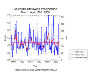 The persistent dryness has depleted soil moisture, especially in the High Plains but also across parts of the West and Southeast, and ravaged crop and rangeland, especially in the southern High Plains. Streamflow (both modeled and observed) averaged below normal across the Southeast, Southwest, northern High Plains, and parts of the Northeast. A more detailed drought discussion can be found below. |
|
|
|
According to the Southeast Regional Climate Center, April was a rather quiet month, with a few notable exceptions. There was some rain throughout the region, although relatively few intense storms and little flooding. Many stations in the north of the region had above normal rainfall for the month, with Richmond, VA exceeding its long term average by over 150%, with a monthly total of 8.32 inches (211 mm). Much of this fell on the 20th through the 22nd of the month, when an upper level low brought rain to much of Virginia and eastern North Carolina. Cape Hatteras, on the Carolina coast, had its third wettest April since 1895. No major recording stations anywhere in the region were more than 1 inch (25 mm) below their long-term average values for the month. During the last 3 months large portions of the coastal plains of all the states had slightly more than normal precipitation. But inland areas had less than normal. Areas west of Charlotte, NC, south of Atlanta, GA and east of Birmingham, AL all had little more than 50% of their usual precipitation since the beginning of February. As a long-term result, and despite the recent rain, the dry conditions continued through most of the region, with the northern parts of Alabama and Georgia, along with west-central North Carolina, still in Extreme Drought. Thus in some regions, particularly in the north, the reservoirs were full at month's end, giving a superficial impression that the drought was over. But ground water levels were still very low, with many wells throughout the region being several feet below their normal level. As noted by the Southern Regional Climate Center, April monthly precipitation totals varied spatially throughout the region. The wettest portions of the Southern Region included most of Arkansas, western Tennessee, and central and northeastern Texas. Elsewhere in Texas, conditions were quite dry with precipitation totals ranging from as low as 4% of normal at El Paso and Del Rio, to approximately 30% near Amarillo and 40% at Houston. In Oklahoma, April precipitation totals were quite low in the panhandle (approximately 5-25% of normal). In Louisiana and southern Mississippi, precipitation totals for the month at most stations varied from approximately 25 to 50% of normal. According to the April 29 USDM, drought conditions were observed in five of the six states within the Southern Region. In Texas, drought has persisted in the western half of the state and conditions have slightly deteriorated there from last month. For instance, as of April 29 approximately 45% of the state was experiencing moderate drought conditions or worse, with approximately 31.8% showing severe drought conditions or worse. Approximately 10% of the state was experiencing extreme or exceptional drought. This area was primarily restricted to the south and south central counties. The eastern half of the state remained clear of drought conditions. In Oklahoma, the panhandle was experiencing moderate to severe drought; however, it covered only an area that makes up less than 9% of the state. In Louisiana, a small area of moderate drought was present in south central parishes and was bounded on either side by abnormally dry conditions. In Mississippi, there was a small band of moderate drought in the southern counties that border Louisiana. In Tennessee, conditions have improved. The easternmost counties remained in moderate drought, whereas the southeastern counties have improved from extreme and exceptional drought to severe drought. As explained by the Midwest Regional Climate Center, precipitation was 150 to 200 percent of normal from southern Missouri northward through the eastern half of Iowa, Wisconsin, northern Minnesota, and the Michigan Upper Peninsula. In contrast, precipitation was 60 to 75 percent of normal for the month from eastern Illinois through most of Indiana, Ohio, and southern Lower Michigan. Areas of above normal precipitation coincided closely with the colder areas of the Midwest in April, and the drier areas with the warmer eastern Midwest. The period February through April 2008 was the wettest on record for the Midwest region, with an average 11.64 inches (29.6 cm) of precipitation. The continuation of wet weather rapidly improved dry conditions across the Midwest, and the April 8 U.S. Drought Monitor marked the first time since the second week of May 2005 that there was no D1 (Moderate) drought depicted in the Midwest. April snowfall was seven times normal across much of Minnesota, and two to three times normal across the northern half of Wisconsin and the Michigan Upper Peninsula. As noted by the High Plains Regional Climate Center, dryness was present over the western two thirds of the High Plains region for the month of April 2008. Several stations in the western part of the region received a tenth of an inch of precipitation or less. Drought conditions varied from abnormally dry (D0) to extreme drought (D3) in the region, with the D3 drought located in the western part of North Dakota and Nebraska. The Colorado State Climatologist's office reported a significant number of dust storms developed this spring in southeast Colorado. As summarized by the Western Regional Climate Center, precipitation was below normal throughout the entire region. Many stations in California and Nevada reported their driest March-April total precipitation. Mountain snow pack, however, remained healthy with most of the Intermountain and Northwest areas reporting above normal snow packs on May 1st. Only the central Sierra was below average at a dismal 56% of normal. The Central Sierra Snow Lab, near Donner Summit, CA, measured only 26 inches (66 cm) of snow for March and April combined. The average is 112 inches (285 cm). Temperatures throughout the West were below normal except for the extreme Southwest, with some locations reporting their coolest April in over a decade. The cool winter and its extension into spring have significantly delayed the snow melt season, especially in the northern half of the region, with concerns rising for late spring flooding from the heavy mountain snow packs. According to National Weather Service reports:
As noted by the Northeast Regional Climate Center, on average, the Northeast saw 90% of its normal April precipitation. The extreme southern and northern states saw the most precipitation this month while the centrally located states saw the least. New York (67% of normal), New Jersey (71% of normal) and Pennsylvania (75% of normal) were the dry spots. Rainfall this month resulted in an improvement in drought conditions in southeastern Maryland and southern Delaware. After being in severe conditions for an extended period, conditions improved to moderate by the end of April. |
|
| A detailed review of
drought and moisture conditions is available for all contiguous U.S.
states, the nine standard regions, and
the nation (contiguous U.S.): STATES: REGIONS:

|
|