| Contents Of This Report: |
 |

|

|
|
|
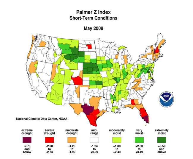
A persistent weather
pattern during much of May resulted in cool temperatures across
much of the country. Wet
weather persisted from the central U.S. into the mid-Atlantic,
where beneficial rains fell across the Upper Mississippi Valley to
the Chesapeake, with Nebraska and Maryland receiving near record
precipitation. Unusually
dry weather persisted across parts of the Southeast, Northeast,
and the Great Lakes regions. Drought conditions improved in the
mid-Atlantic and parts of the Southeast and northern Plains, but
deteriorated along the Texas coast (May 27 USDM
versus April 29
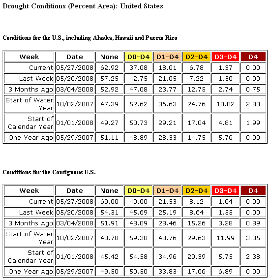
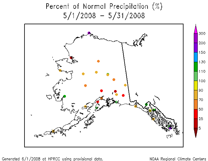
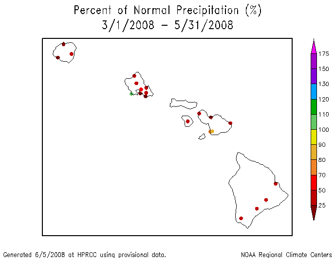
USDM). May was generally drier than average in Alaska, Puerto Rico, and across the Hawaiian Islands. The persistent dryness in Hawaii has resulted in reduced streamflow and contributed to below-normal rainfall for at least the last 90 days.  Drought conditions in the Southeast continued to improve, with USDM statistics showing moderate to extreme drought covering about 40% of the region by the end of May compared to about 43% at the end of April. However, long-term hydrologic deficits remained, with low groundwater and streamflow levels and several states still suffering from severe long-term hydrologic drought.  |
According to the USDM,
about 26% of the
West was experiencing moderate to severe drought as of May 27,
down about 10% from April. The percent area in moderate to extreme
drought based on the
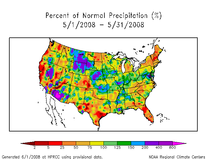
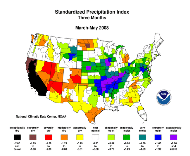
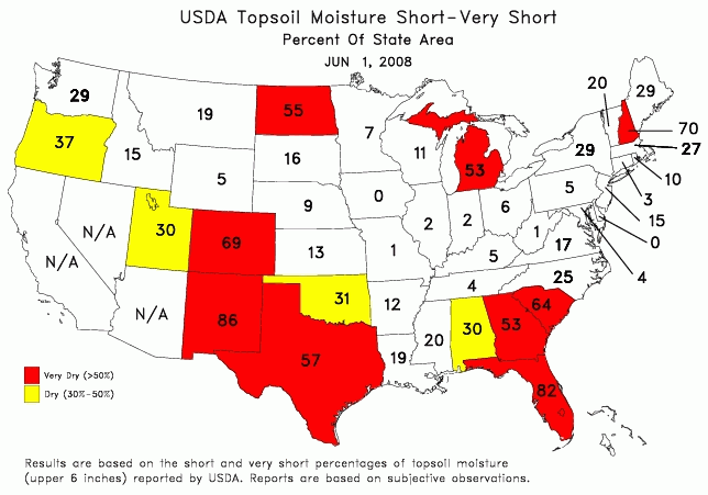
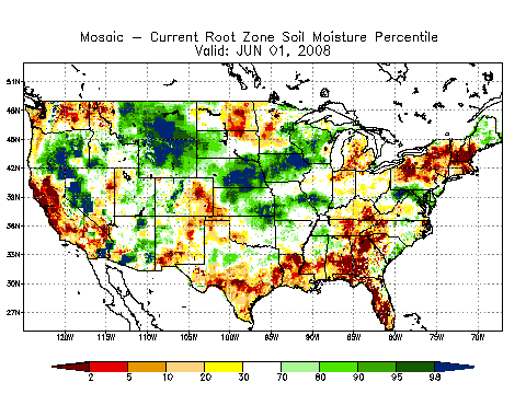
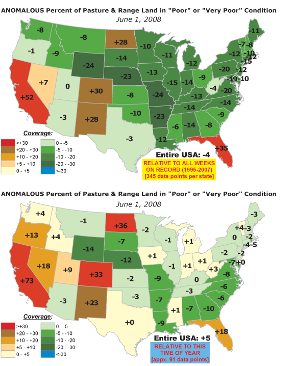
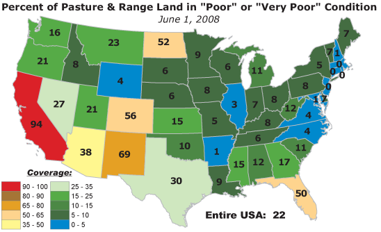
Palmer Drought Index was about 33%. This month broke the dryness of the previous two months for areas of the Southwest. Arizona had an unusually wet month and California was slightly below normal. Despite some relief in southern California and the Sierra Nevadas during May, California experienced its driest March-May period on record. Much of the West was still below to much below normal for this three month period. The Southwest snowpack has nearly melted out. Toward the end of May, a strong cold front followed by nearly stationary upper level low pressure brought well above normal precipitation to much of the Southwest from southern California to New Mexico. But dry and windy weather during the previous 11 weeks had left many areas parched and fire danger remained high in areas of Arizona, New Mexico, California, and Nevada. Snow water equivalent in the Cascades and scattered areas across the northern and central Rockies was still well above normal during May. Delayed snowmelt and near normal temperatures for May contributed to below-normal reservoir levels across parts of the Northwest. 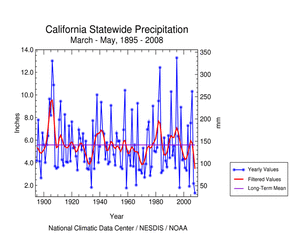 The persistent dryness has depleted soil moisture, especially in the High Plains but also across parts of the West, Northeast, and Southeast, and ravaged crop and rangeland, especially in the southern High Plains and California. Streamflow (both modeled and observed) averaged below normal across the Southeast, Northeast, northern High Plains, and parts of the Southwest. A more detailed drought discussion can be found below. |
|
|
|
According to the Southeast Regional Climate Center, May was a rather cool month. Puerto Rico saw some flash flooding early in the month and again the third week of May. The rest of the region had a series of cold front passages, which resulted in rain throughout the region, with some areas, such as northern Virginia and northwest Alabama, a little wetter than normal, and other locations, such as the DC area, receiving about 200% of normal precipitation. Other areas, such as southeast Alabama and the Tennessee, North Carolina, Virginia border regions were a little drier than normal. Dry conditions continued through most of the region, with the northern parts of Alabama and Georgia, along with west-central North Carolina, still in Extreme Drought. Conditions in Florida and localized areas of Alabama, Georgia, and North Carolina saw drought worsen. While some reservoirs remained full at month's end, ground water levels were still very low, with many wells throughout the region being several feet below their normal levels. As noted by the Southern Regional Climate Center, drought conditions were observed in three corners region of the southern High Plains in May. Specifically, drought was present in western Oklahoma/northeastern Texas, southern Texas, and eastern Tennessee. In Oklahoma, drought was restricted to the three panhandle counties. As of the June 3 USDM report, the two western panhandle counties were experiencing extreme drought, while the easternmost panhandle county was showing signs of moderate to severe drought. The extreme drought also extended slightly into the northern panhandle of Texas, however; it was restricted to only two counties. Another small pocket of extreme drought was also present in southern Texas. Most of the southern half of the state was experiencing moderate to severe drought, which was a direct consequence of the dry conditions that were observed there during May. In total, approximately 44% of Texas was experiencing moderate drought or worse, with approximately 28% of the state showing severe drought or worse, and only 1.5% of the state indicating conditions of extreme drought. As was the case during April in Tennessee, drought was restricted to the eastern portions of the state. Approximately 37% of the state had moderate drought or worse and approximately one tenth of the state had severe drought. As explained by the Midwest Regional Climate Center, precipitation was generally near to well above normal across the southern two-thirds of the region, and from 50 percent to 75 percent of normal across the northern third. The heaviest precipitation, from 150 percent to 200 percent of normal, occurred in two bands. One extended across the central third of Ohio, and a second extended from southwestern Missouri eastward across southern Illinois into southern Indiana. Notable dry areas were southeastern Kentucky, where precipitation was about 60 percent of normal, and in northwestern Minnesota, where precipitation was less than 50 percent of normal in some locations. The return of drier weather to northwestern Minnesota resulted in the depiction of Moderate Drought (D1) in that area in the May 20 USDM. The cool, wet weather slowed progress in spring planting of corn and soybeans in the Midwest during the month. During the first half of the month corn planting was 30 to 50 percent behind the five year average. Several brief periods of dry weather during the last half of the month helped producers make progress, and by the end of the month corn planting was 80 to 95 percent complete, only from 5 to 10 percent behind normal. As noted by the High Plains Regional Climate Center, May proved to be a diverse month. Colorado and North Dakota were characterized by well below normal precipitation. These areas received as little as 5-25% of their normal precipitation for the month. On the other end of the spectrum, western South Dakota, central and eastern Nebraska, and north central and southern Kansas received well above normal precipitation during May with local areas receiving as much as 300% of normal. Drought persisted over areas of North Dakota, northwestern Nebraska, southwestern Wyoming, and along the Colorado-Kansas border during May. Widespread retreat of drought occurred in northwestern Nebraska (drought downgraded from D3 to D2), southwest Nebraska (D1 to D0), central Wyoming (D1 to D0), and South Dakota (D1, D2, and D3 eliminated). Conversely, drought intensified along the Kansas-Colorado border (D2 to D3). Seasonal outlooks indicated that all areas of drought in the region should improve through the summer. As summarized by the Western Regional Climate Center, precipitation was mixed across the region in May. Portions of Wyoming and Montana recorded an extremely wet month while the Pacific Northwest and California were quite dry. Lander, WY measured 6.13 in (156 mm) of precipitation breaking their all time May record. Some of the highest elevations of Wyoming and Montana actually had their snow pack increase from May first to June first. Flagstaff, AZ, recorded their snowiest May ever with 8.7 in (22 cm). San Francisco had no measurable rain in May leading to their driest spring total (March-May) ever, 0.47 in (12 mm). Normally San Francisco receives 24% of their annual rainfall during these three months. This year those same months brought only 3% of the 2007-2008 seasonal total to date (since July 1). Preliminary data from the WRCC California Climate Tracker indicated that 2008 had the driest March-May statewide average in the 114-year record extending from 1895, with March-May 2008 having 22% of the long-term mean. Although most of California was dry, an unusual event on May 23 produced locally heavy rain, and even tornadoes, in the mountains of southern California leading to local flash flooding, mudslides and road closures. Over 2 inches (51 mm) of rain fell in some locations in the morning hours of May 23. Bakersfield measured .08 in (2 mm) on the 23rd, breaking an 87-day period with no measurable rain. According to National Weather Service reports, precipitation in Alaska for the month was mixed to the south. Around Juneau, the northern and central outer coastal locations received only 67% to 77% of normal rainfall. Central inner channel and southern locations, on the other hand, saw anywhere from 111% to 151% of their normal rainfall amounts for May. Weather Service Office Annette recorded 2.59 inches of rain on the 14th. Two days later, Juneau International Airport recorded a record rainfall of 1.29 inches. In all locations, rainfall was generally concentrated during the first week of May and then again between the 9th and the 17th. By and large, the second half of the month was dry for all panhandle locations. Sitka and Juneau recorded their 3rd longest dry stretch for the month of May with 9 and 10 days, respectively. Yakutat recorded their 4th longest dry stretch for the month of May with 9 days. Cumulative precipitation through May varied from near normal to a few inches above normal for all locations except the far northern portions of the panhandle along the outer coast where a cumulative precipitation deficit of over 10 inches continued to increase. Near Anchorage, Kodiak had its second wettest May on record while Bethel had its second highest winter snowfall total in the past 30 years. A daily rainfall record for May was also set in Valdez. In central Alaska, Fairbanks had near-normal precipitation in May. With the exception of higher elevations where snow showers persisted through the end of the month, all May precipitation around the city came in the form of rain. Winter snowpack was largely melted by the end of the month. To the north, Barrow set a daily snowfall record on May 27 with 2 inches (and 0.14 inches water equivalent). The same storm led to another record snowfall in Nome of 1.8 inches. As noted by the Northeast Regional Climate Center, the Northeast received 3.50 inches (8.89 cm) or 88% of the normal rainfall for May. Southern states saw above normal precipitation totals while New York and the New England states averaged below normal. Among the 12 states, Maryland was the wettest, with 158% of normal rainfall and New Hampshire the driest, at 40% of their normal May precipitation amount. It was the 9th driest May since 1895 in New Hampshire and the 13th driest in Vermont. At month's end, only a small area in southern West Virginia was still experiencing abnormally dry conditions. |
|
| A detailed review of
drought and moisture conditions is available for all contiguous U.S.
states, the nine standard regions, and
the nation (contiguous U.S.): STATES: REGIONS:
|
|