| In the United States,
significant precipitation during the winter season alleviated
drought conditions along the immediate West Coast, although severe
to extreme drought classification continued in May throughout the
Intermountain West, the Northern Rockies, and southward into
Arizona. Exceptional drought classification was noted through parts
of Montana and Idaho. Moderate drought conditions developed in
parts of the Southeast by the end of April and continued through
May. |

larger
image
|
For comprehensive drought analysis, please see the U.S. drought report
for May.

larger
image
|
The western wildfire
season got off to an above average start by early May with fire
danger at unprecedented high levels for early spring in parts of
California (NIFC). Several large fires affected the southwestern
part of the state, where the Eagle and Cerrito fires charred more
than 11,500 hectares (28,000 acres) and destroyed more than a dozen
houses (NCTimes). |
For additional details on the 2004 wildfire season in the United
States, see the May Wildfire Summary.
Rain and late season snow blanketed areas of Canada's main
grain-growing region on the 12th, including areas of Manitoba,
Alberta and Saskatchewan. The storm dumped the equivalent of 10-40
mm (0.4 to 1.6 inches) of water on some parts of the prairie
provinces, where prolonged drought has plagued the region
(Reuters).
| Long term drought
continued across areas of Africa, including the Greater Horn and
parts of southern Africa (WFP). Seasonal rains brought relief to
some areas during late April and into May. |
 larger
image
larger
image
|

larger
image
|
Below normal rainfall
during March through May resulted in worsening drought conditions
in areas of eastern and southern Australia. Rainfall deficiencies
in parts of Queensland and New South Wales were particularly acute.
The latest drought statement can be obtained from the
Australian Bureau of Meteorology. |


larger
image
|
Showers and
thunderstorms brought torrential rains and flooding to parts of
Texas during May 1-2. Flooding affected northern and coastal
sections of the state, resulting in 6 deaths (Associated
Press). |
Flooding that began at
the beginning of 2004 along the Zambezi River affected over 21,000
people living in Zambia. Western and northern provinces of the
country were the worst affected (OCHA).
In Kenya, several thousand people were displaced by flooding in
early May, mostly in the western part of the country. There were 15
fatalities reported due to the flooding (AFP). Kenya's wet season
runs from March through May. |
 Areas Affected By Flooding
|
Flash floods were responsible for 8 deaths in western Iran on
the 2nd (AFP). Heavy rainfall along the Deleshir River in the
Kermanshah province caused the river to quickly rise above the
flood stage, resulting in the fatalities.
Near record to record rainfall totals in the Jiangxi Province of
eastern China during May 11-15 caused flooding and landslides that
killed seven people. (Disaster Relief)
Heavy rains caused flooding in Texas and Oklahoma on the 14th.
More than 432 mm (17 inches) of rain fell in nine hours placing 644
square km (400 square miles) of Robertson County, TX underwater. At
least one person died in an automobile accident due to the heavy
rains, and as many as 200 homes were damaged from the rising flood
waters. (Associated Press)

larger
image
|
A low-pressure system
originating from Central America crossed the Caribbean and affected
Hispanola during May 18-25, bringing exceptionally heavy showers
and thunderstorms to Haiti and the Dominican Republic. Rainfall
amounts exceeding 500 mm (19.7 inches) were common across the
border areas of Haiti and the Dominican Republic during this time
period. Flooding was extensive in the town of Jimani in the
southwestern Dominican Republic, where 250 mm (10 inches) of rain
fell in just 24 hours, causing the Soliel River to overflow its
banks. In neighboring Mapou, Haiti, nearly half the homes in the
town were destroyed, numbering 1,300. Widespread flooding and
mudslides in the two countries were blamed for nearly 2,000 deaths
(Reuters/AFP/CNN/Associated Press). |
For an archive of flood events worldwide, see the
Dartmouth Flood Observatory.

| Strong thunderstorms
produced damaging winds, hail and a few tornadoes through parts of
Minnesota on the 9th. More than 22,000 customers lost electricity
in the Minneapolis-St. Paul area (Associated Press). |
 larger
image
larger
image
|

Tornado on May 22 in Furnas county,
Nebraska
|
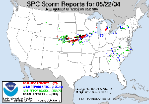
A significant outbreak
of severe weather and tornadoes affected portions of the U.S. Great
Plains during May 21-24, 2004. There were 179 reported tornadoes
during this period, along with many reports of hail and wind
damage. |
| A strong tornado
rated F-4 on the Fujita Scale virtually destroyed the town of
Hallam, Nebraska on the 22nd, and caused one fatality
(Reuters). |
 Derailed Train Photo Near Hallam,
NE
Derailed Train Photo Near Hallam,
NE
|
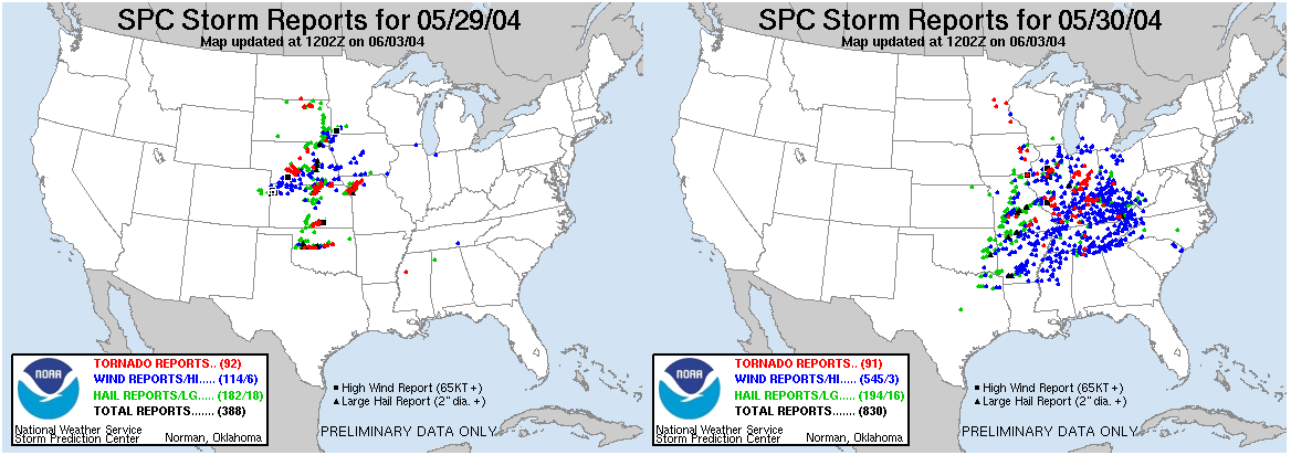
| Another outbreak of
severe weather affected areas of the Plains states eastward into
the Tennessee Valley during May 29-30. |
 larger
image
larger
image
|
In southern China, a rare tornado struck the town of Qishi in
Guangdong province on the 8th. The tornado injured 85 people and
killed two. A total of 462 people were made homeless, as more than
200 houses were destroyed (Associated Press).

 larger
image
larger
image
|
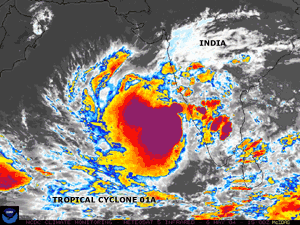
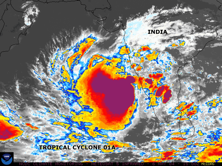
Tropical Cyclone 01A
developed in the Arabian Sea on the 5th and dissipated off the west
coast of India by the 10th. Maximum sustained winds at the storm's
peak reached 85 km/hr (45 knots or 50 mph). Although the storm
never made landfall, there were 23 fishermen from India reported
missing off the coast of the southern state of Kerala. Heavy rains
pounded coastal areas and badly damaged around 1,500 homes
(AFP). |
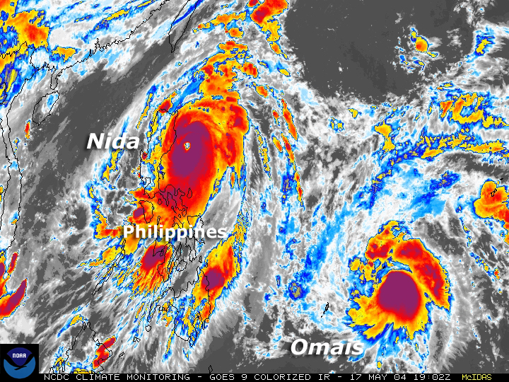
| Typhoon Nida developed as a
tropical storm in the western Pacific Ocean on the 14th and quickly
reached typhoon strength the same day. By the 16th Nida developed
into a Super Typhoon. Typhoon Nida made landfall in the Philippines
as a category 4 storm on the 18th. Maximum sustained winds were 260
km/hr (140 knots or 161 mph) at the time of landfall, and the
typhoon caused between 20-30 deaths. The typhoon forced the
evacuation of thousands of people, and caused a ferry to overturn
that was carrying 168 passengers off the central Camotes Islands.
President Gloria Macapagal Arroyo declared a disaster in eight
eastern provinces (Associated Press). Nida was the fourth typhoon
to hit the archipelago this year. |
 larger
image
larger
image
|
 larger
image
larger
image
|
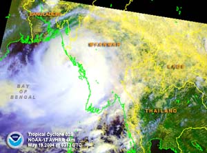
Tropical Cyclone 01B
developed in the Bay of Bengal on the 17th and made landfall along
the north coast of Burma near the border with Bangladesh on the
19th with maximum sustained winds near 110 km/hr (60 knots or 70
mph). The storm was responsible for at least 220 deaths in Burma,
along with the loss of at least 84 fishing vessels or ships
(AFP/OCHA). |
A table containing the
Accumulated Cyclone Energy (ACE) index for global tropical
cyclones occurring during the month of May 2004 is available.
No reports of significant extratropical cyclones were received
during May 2004

| An unusual late-season
snow fell across the Kashmir region along the border of India and
Pakistan during early May. Indian defense ministry officials
reported that the army was dispatched in an effort to rescue some
20,000 nomads trapped in the Himalayan areas of Kashmir, where
heavy snow had effectively cut off the region (AFP). |
 larger
image
larger
image
|
In France, unseasonably heavy snow fell on the 9th in the
northeast areas of the country. Heavy snow accumulation on the
order of 30 cm (one foot) was observed at elevations above 900
meters (2,970 feet). The snow caused road closures and power
outages, with some 5,000 households losing electricity (AFP).
References:
Basist, A., N.C. Grody, T.C. Peterson and C.N. Williams, 1998:
Using the Special Sensor Microwave/Imager to Monitor Land Surface
Temperatures, Wetness, and Snow Cover. Journal of Applied
Meteorology, 37, 888-911.
Peterson, Thomas C. and Russell S. Vose, 1997: An overview of
the Global Historical Climatology Network temperature data base.
Bulletin of the American Meteorological Society,
78, 2837-2849.
|


