
 India Flooding |
Global Hazards And Significant
Events
|

| During spring, rain and snowfall ameliorated drought conditions throughout portions of the northern and central Rockies. Drought conditions expanded throughout portions of the Mississippi Valley by early July 2005. By late in the month, the U.S. Department of Agriculture declared all of Illinois a disaster area due to the general crop failure caused by drought (Reuters). |
 U.S. Drought Monitor |
| For comprehensive drought analysis, please see the current U.S. drought report. Additional information on the western wildfires can be obtained from the 2005 wildfire season page. |
| Throughout the southwestern United States, a severe heat wave gripped the region during early to mid-July. Maximum temperatures above 40°C (104°F) affected parts of Nevada, California, Arizona and southern Utah. Numerous temperature records were set around the region, and Las Vegas, NV tied their all-time record high temperature of 47.2°C (117°F) on the 19th, equalling the old record set on July 24, 1942. Death Valley had 7 consecutive days (July 14-20) with high temperatures equal to or above 51.7°C (125°F). At least 13 deaths were blamed on the heat wave in Arizona (Associated Press). The heat wave had spread to the East Coast by the 25th. |
 High Temperatures |
| Heat and drought affected much of southern Europe and North Africa during July. In France, water rationing was in place throughout half of the country, with western areas the most acutely affected by drought. Neighboring Spain and Portugal experienced the worst drought conditions since the late 1940s, with 97 percent of Portugal affected by severe to extreme drought. In Algeria, a heat wave pushed temperatures as high as 50°C (121°F) and claimed more than a dozen lives. Throughout the entire region, forest fires charred thousands of hectares (acres) (BBC News). |
 African Weather Assessment |
Long-term drought continued in parts of the Greater Horn and southern Africa, from parts of Ethiopia and southern Somalia southward into Malawi, Zambia and Zimbabwe. For the latest African analysis and forecast, see the Famine Early Warning System Network. |
| Across Australia, July was unseasonably warm, with mean temperatures 1.01°C (1.82°F) above normal. It was the fifth warmest July in the post-1950 period (Australian Bureau of Meteorology). |
 Australia Temperature Anomalies |


| In Romania, flooding affected the northeastern part of the country during the first half of July with 23 fatalities reported along with destruction of more than 2,300 homes. The flooding was reportedly the worst in 30 years, with preliminary damage estimates near $1.2 billion (USD) (Reuters). Romania also experienced flooding during the month of May 2005. In addition, flooding affected adjacent areas of Bulgaria where around 48,000 residential and public buildings had been flooded throughout the country (OCHA). |
 Flooding in Romania |
 Asia Precipitation Anomalies |
Seasonal flooding which began in May 2005 across southern China continued into July. In the Sichuan province, 49 people were killed and over 400,000 evacuated due to flooding and landslides by July 13 (OCHA). |
| In Pakistan, unusually warm temperatures in mountainous areas of northern Pakistan accelerated snowmelt and brought extensive flooding along the Kabul, Swat, Sindh and Indus Rivers (OCHA). In far northeastern India, heavy monsoon rains brought flooding to the Brahmaputra River which displaced 8,000 people in Assam state and resulted in at least 12 deaths (AFP). |
 India Flooding |
In India's western state of Maharashtra, exceptionally heavy rainfall was recorded on July 26 when 944 mm (37.1 inches) of rain fell in the state capital of Mumbai (Bombay), breaking the city's 24-hour rainfall record. This unprecedented rainfall produced widespread, massive flooding that was responsible for the deaths of over 1,000 people in the Maharashtra state, including at least 429 in the city of Mumbai (Bombay). Estimated economic losses were near $3.5 billion (USD) (Associated Press/CBS News/BBC News/Reuters). |
| In Austria, flooding along the Salzach River prompted the evacuation of a hospital at Mittersill on July 12. At least 60 patients and staff were evacuated to Salzburg after heavy rains produced the flooding (AFP). |

| Severe thunderstorms that affected portions of the United Kingdom produced a tornado that struck the city of Birmingham on the afternoon of July 28. The tornado damaged buildings and cars, uprooted trees and tore roofs off houses in an area south of the city's center. There were 23 injuries but no fatalities (BBC News/AFP). |

 Satellite Image Of Cindy |
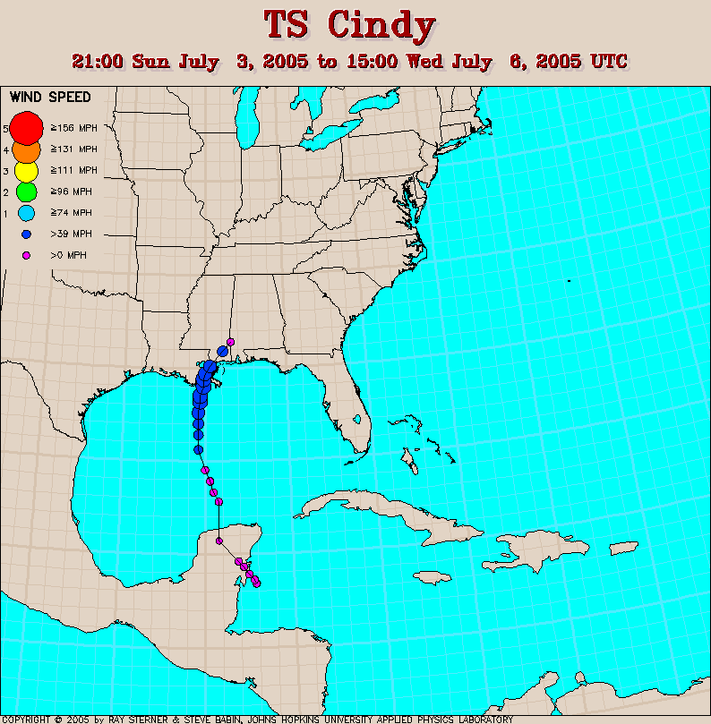
Tropical Storm Cindy developed as a depression in the far western Caribbean on the 3rd, tracking across the Yucatan Peninsula before entering the Gulf of Mexico and reaching tropical storm strength by the 5th. Cindy made landfall near Grand Isle, Louisiana late the same day with maximum sustained winds near 110 km/hr (60 knots or 70 mph). More than 300,000 homes and businesses lost electricity in Louisiana, Alabama and Mississippi (Associated Press). |
| Heavy rainfall and flooding accompanied the storm as it moved inland, with rainfall amounts of 50-100 mm (2-4 inches) along its path into the Mid-Atlantic states. Localized severe weather including a few tornadoes also accompanied Cindy's remnants. |
 Tropical Storm Cindy Rainfall |
| In the eastern Pacific, Tropical Storm Dora developed on July 4 about 75 km (45 miles) west-southwest of Acapulco, Mexico. Maximum sustained winds were near 65 km/hr (35 knots or 40 mph), although the center of Dora moved parallel to the Mexican coastline and did not make landfall. The primary effect of the tropical storm was heavy rainfall along the coast. Dora dissipated on the 6th. |
 Satellite Image Of Dennis |
Hurricane Dennis developed as a depression in the southeastern Caribbean Sea on the 4th, reaching tropical storm strength on the 5th. This was the earliest date on record for four named storms to have formed in the Atlantic Ocean. The storm achieved hurricane status by the 6th, passing just north of Jamaica on the 7th and dumping very heavy rainfall on the island. Dennis made landfall in south-central Cuba on the 8th as a category-four hurricane, or the strongest hurricane on record for so early in the season. There were 16 deaths in Cuba and 25 in Haiti. Damage estimates in Cuba were near $1.4 billion (USD), with 120,000 houses damaged or destroyed. It was Cuba's highest death toll from a hurricane since Flora in October 1963 when over 1,100 people perished (Reuters/Associated Press). |
| Dennis continued northwestward into the southeastern Gulf of Mexico, having weakned from its passage over Cuba. The hurricane re-attained category-four strength over the eastern Gulf of Mexico by the 9th, but weakened to category-three intensity at the time of a final landfall near Pensacola, Florida on the 10th. Maximum sustained winds at the time of landfall were near 195 km/hr (105 knots or 120 mph). There were 9 hurricane-related fatalities in the U.S. (Florida, Mississippi and Georgia), and preliminary estimates of insured losses ranged from $1 to $1.5 billion (USD). Heavy rainfall affected a wide area from the Gulf Coast, Southeast and Mississippi Valley. |
 Radar Animation of Hurricane Dennis |
 Satellite Image Of Emily |
Hurricane Emily developed in the central tropical Atlantic Ocean on the 10th as a depression and reached tropical storm strength by the 11th. Emily became a hurricane late on the 13th and slammed into Grenada early on the 14th with winds near 150 km/hr (80 knots 90 mph). Emily passed south of Haiti on the 15th and was blamed for 6 deaths (AFP). Jamaica received heavy rainfall from the hurricane on the 16th, although the center passed south of the island. |
| Emily continued westward, reaching Mexico's Yucatan Peninsula near Cozumel on the 18th as a category-four hurricane with maximum sustained winds near 215 km/hr (120 knots or 135 mph). The hurricane entered the Gulf of Mexico and continued westward, reaching the northeastern coast of Mexico near Boca Madre, or about 120 km (75 miles) south of Brownsville, Texas, on the 20th. Maxiumum sustained winds at the time of landfall were near 205 km/hr (110 knots or 125 mph), or a category-three hurricane. In Mexico, there was one fatality reported, with many houses damaged and agricultural fields flooded (Associated Press). |
 Emily Satellite Animation (~7MB) |
 Satellite Animation of Haitang (~6.5MB) |
Typhoon Haitang developed in the western Pacific Ocean on the 11th and reached typhoon status on the 13th. Haitang made an initial landfall in Taiwan on the 18th with maximum sustained winds near 195 km/hr (105 knots or 120 mph). Flooding and mudslides accompanied the typhoon, with up to one meter (over three feet) of rainfall reported in some mountainous areas of Taiwan (CNN). Haitang then continued westward, reaching Huangqi, China on the 19th with top sustained winds near 120 km/hr (65 knots or 75 mph). There were 12 deaths in Taiwan and 1 in China's Zhejiang province (Associated Press). |
| Tropical Storm Banyan developed as a depression in the northwestern Pacific Ocean on the 21st, reaching tropical storm strength the next day. Banyan tracked to the north and skirted the east coast of Japan on the 26th with maximum sustained winds near 75 km/hr (40 knots or 45 mph). The primary effect from Banyan was heavy rainfall. |
 Tropical Storm Banyan |
| In the northwest Pacific Ocean, Tropical Storm Washi developed in the South China Sea on the 28th and moved across the island of Hainan on the 30th. The depression emerged in the Gulf of Tonkin and made landfall in northern Vietnam on the 31st with maximum sustained winds near 85 km/hr (45 knots or 50 mph). The primary impact from Washi was locally heavy rainfall along its path. |
| For 2005 basin tropical cyclone
statistics, please refer to the following: Australian Basin North Indian Ocean Basin Western North Pacific Basin South Pacific Basin South Indian Ocean Basin Northeast Pacific Ocean Basin Atlantic Basin |

| No reports of significant
extratropical cyclones were received during July 2005 |

| No reports of severe winter weather
were received during July 2005 |