National Overview:

- Climate Highlights — October
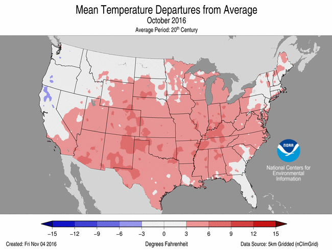 October Average Temperature Departures |
 October Percent of Average Precipitation |
Temperature
- The contiguous U.S. average October temperature was 57.7°F, 3.6°F above the 20th century average, making it the third warmest October in the 122-year period of record and the warmest since 1963. The last three Octobers are among the six warmest in the 122-year record.
- Temperatures across most of the country were much above average during October. New Mexico had it warmest October on record with an average temperature that was 5.8°F above the 20th century average. Texas had its second warmest October, while Arizona, Colorado and Oklahoma each had their third warmest. Only three states, Montana, Oregon and Washington, were near average.
- Over the last 30 years, average October temperatures for the contiguous U.S. have warmed by 0.65°F per decade. Only September has warmed more (+0.74°F per decade).
- As has been the case for much of the decade, minimum (nighttime) temperatures were relatively warmer than normal, compared to maximum (daytime) temperatures.
- The contiguous U.S. average maximum (daytime) temperature during October was 69.9°F, 3.1°F above the 20th century average, the sixth warmest on record. Above average maximum temperatures occurred across much of the southern and southeastern U.S. Near average maximum temperatures were observed in parts of the West and Northern High Plains. Below average maximum temperatures were confined to the Northwest.
- The contiguous U.S. average minimum (nighttime) temperature during October was 46.2°F, which is 4.8°F above the 20th century average, the second warmest on record. No state in the Lower 48 observed near average or below average October minimum temperatures.
- During October there were 7,025 record warm daily high (3,147) and low (3,878) temperature records. This was more than 10 times the 508 record cold daily high (316) and low (192) temperature records.
- Based on NOAA's Residential Energy Demand Temperature Index (REDTI), for October 2016 ranked ninth lowest in the 122-year record for October, due to much-warmer-than-normal temperatures across most of the country which decreased heating demand.
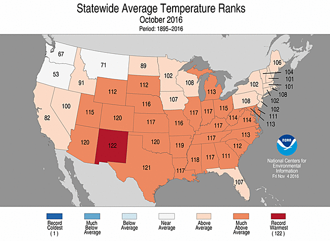
October 2016 Statewide Temperature Ranks
Precipitation
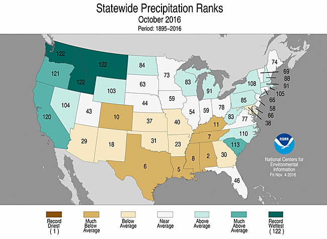
October 2016 Precipitation Ranks
- The October precipitation total for the contiguous U.S. was 2.33 inches, 0.17 inch above the 20th century average, and ranked near the middle of the 122-year period of record. Wet conditions dominated the Pacific Northwest and the coastal Southeast. Dry conditions prevailed in the South and the interior Southeast, where drought intensified significantly during October.
- Below-average precipitation continued for the second consecutive month in areas of the South. Alabama, Louisiana, Mississippi, Tennessee and Texas had one of their 10 driest Octobers on record. Separately, Colorado had its 10th driest October.
- Rainfall associated with Hurricane Matthew represented a notable exception to the prevailing dry conditions in the southern and eastern U.S.
- Hurricane Matthew formed in the Caribbean and quickly became a Category 5 hurricane, the first in the Atlantic since Hurricane Felix in 2007. Matthew skirted Florida's Atlantic coastline before making landfall as a Category 1 storm just south of Myrtle Beach, South Carolina, on October 8.
- Inland flooding associated with Matthew was especially severe in coastal Georgia, the eastern Carolinas and southeastern Virginia. The region suffered monumental agricultural losses to poultry, orchards, vegetable and fiber crops.
- According to the November 1 U.S. Drought Monitor report, drought increased from 19.4 percent of the contiguous U.S. in early October to 26.8 percent by the end of the month. The majority of the expansion occurred in the South and Southeast where many locations did not receive any precipitation during the month of October.
- In the South, the drought footprint quadrupled, from 10 percent coverage to 42 percent coverage, while in the Southeast it increased from 25 percent to 39 percent.
- While drought conditions in the Northeast expanded (41 percent to 51 percent) during the month, the worse drought categories (extreme to exceptional drought) decreased from 6 percent to 1 percent.
- Moderate to exceptional drought decreased from 30 percent to 26 percent in the West. The majority of this improvement was the result of the early start to the wet season in the Northwest.
- Climate Highlights — year-to-date (Jan-Oct)
 Jan-Oct Average Temperature Departures |
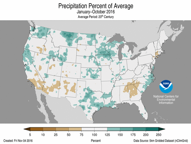 Jan-Oct Percent of Average Precipitation |
Temperature
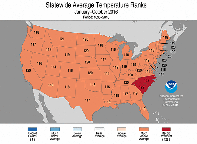
Jan-Oct Statewide Temperature Ranks
- The year-to-date (January-October) contiguous U.S. average temperature was 57.8°F, 2.8°F above average, making it the second warmest on record, behind only 2012.
- South Carolina had its warmest start to the year with an average temperature anomaly that was 2.4 above their 20th century average. North Carolina tied with 2012 for its warmest January-October period. The average temperature anomaly was 2.3 above their 20th century average.
- Every other state in the CONUS had at least their ninth warmest start to the year.
- The contiguous U.S. average maximum (daytime) temperature during January-October was 69.8°F, 2.5°F above the 20th century average, the fifth warmest on record. Every state across the Lower 48 had an above-average maximum temperature for the year to date with much-above average maximum temperatures across the West, Central and Northern Plains, Upper Midwest, Northeast, and Southeast.
- The contiguous U.S. average minimum (nighttime) temperature during January-October was 45.8°F, 3.0°F above the 20th century average, the second warmest on record. Only in 2012 was the January-October minimum temperature was warmer at 46.1°F. Every state across the Lower 48 had a much-above-average minimum temperature with record warm minimum temperatures observed across parts of the Northern Rockies and Plains, Central Plains, and Southeast.
- Based on REDTI, the contiguous U.S. temperature-related energy demand during January-October was 44 percent below average and the 16th lowest value on record.
Precipitation
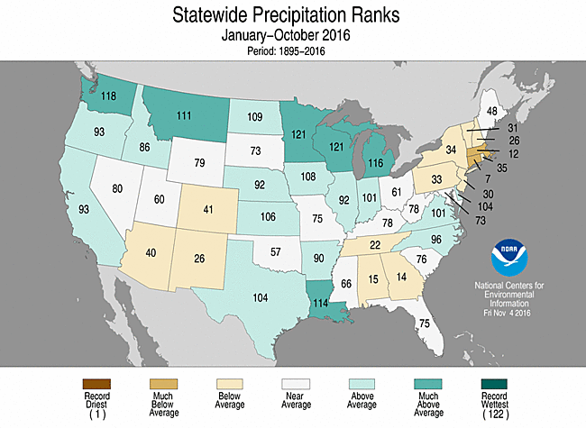
- The year-to-date (January-October) contiguous U.S. precipitation total was 27.16 inches, 1.80 inches above average, and the 21st wettest year to date on record.
- Both Minnesota and Wisconsin had their second wettest January-October period on record. Year-to-date (YTD) precipitation totals were also much above average for Michigan, Montana, Louisiana and Washington. Long term dryness shows up in the Northeast where Connecticut had its seventh driest YTD period and Massachusetts its 12th driest.
- Precipitation departures from average for the January-October period were more than 20 inches for parts of the Louisiana coast, eastern North Carolina, and areas around the Northwest. Areas in the southern Appalachians had below normal precipitation during the period. In this region, there were some small pockets that received 20 inches below what is typically observed for the first ten months of the year.
Jan-Oct Statewide Precipitation Ranks
Extremes
- The U.S. Climate Extremes Index (USCEI) for the year to date was 65 percent above average and the fifth highest value on record. On the national scale, extremes in warm maximum and minimum temperatures, the spatial extent of wetness and one-day precipitation totals were above average. The USCEI is an index that tracks extremes (falling in the upper or lower 10 percent of the record) in land-falling tropical cyclones, temperature, precipitation and drought across the contiguous U.S.
- Regionally, extremes were much above average in the Northeast, Southeast, Ohio Valley, South, and the Northern Rockies and Plains. In the Northeast, Ohio Valley, and Northern Rockies and Plains, extremes in warm maximum and minimum temperatures were much above average. In the Southeast extremes in warm minimum temperatures were elevated, while in the South extremes in warm minimum temperatures, spatial extent of wetness, and one-day precipitation totals were much above average. In the Ohio Valley, the year to date saw the second highest CEI on record due to extremes in warm minimum temperatures, the spatial extent of wetness, one-day precipitation totals, and the number of days with precipitation.
**A comparison of the national temperature departure from average as calculated by NCDC's operational dataset (nClimDiv), the U.S. Historical Climatology Network (USHCN), and the U.S. Climate Reference Network (USCRN) is available on our National Temperature Index page.**
Regional Highlights:
These regional summaries were provided by the six Regional Climate Centers and reflect conditions in their respective regions. These six regions differ spatially from the nine climatic regions of the National Centers for Environmental Information.
- Northeast Region: (Information provided by the Northeast Regional Climate Center)
- October was another warmer-than- normal month for the Northeast. The region's average temperature of 52.3 degrees F (11.3 degrees C) was 2.9 degrees F (1.6 degrees C) above normal, making it the 12th warmest October since 1895. All twelve states were warmer than normal, with seven ranking the this October among their top 20 warmest: West Virginia, 9th warmest; Maryland, 10thwarmest; Delaware, 12th warmest; Pennsylvania, 15th warmest; Rhode Island, 16th warmest; Maine, 18th warmest; and Vermont, 20th warmest. Average temperatures ranged from 2.2 degrees F (1.2 degrees C) above normal in New Jersey to 3.9 degrees F (2.2 degrees C) above normal in West Virginia.
- The Northeast wrapped up October with 4.15 inches (105.41 mm) of precipitation, which was 108 percent of normal. Five states received above-normal precipitation, with New York and Rhode Island having their 15th wettest and 18th wettest Octobers on record, respectively. Precipitation for all states ranged from 66 percent of normal in Maryland to 135 percent of normal in Rhode Island.
- The October 6 U.S. Drought Monitor showed 41 percent of the Northeast was experiencing moderate, severe, or extreme drought, with another 24 percent being abnormally dry. Areas such as central New York, north-central Pennsylvania, and southern coastal Maine received above-normal precipitation, which helped eased drought conditions. However, drought conditions expanded or remained unchanged in eastern Pennsylvania, northern New Jersey, eastern New York, and much of the rest of New England. The U.S. Drought Monitor released on October 27 indicated 52 percent of the Northeast was in a moderate, severe, or extreme drought, with another 16 percent being abnormally dry. Preliminary USGS data indicated streamflow and groundwater continued to be at record or near record low levels during the month. For instance, the Piscataquis River near Dover-Foxcroft, Maine and the Saco River near Cornish, Maine, both with over 100 years of data, had record low 7-day average streamflow for the October 12-19 period. Shallow, private wells continued to run dry, and water levels in reservoirs continued to decline. An October 21 press release from New Jersey's Department of Environmental Protection indicated water levels for the state's major reservoir systems ranged from less than 45 percent to 74 percent of capacity. Due to low reservoir levels, Connecticut officials declared a rare public water supply emergency for several towns, another city began buying water from the Massachusetts Water Resources Authority, and Dorset, Vermont shut off its water system each night for a week to allow its reservoir to recharge. As of October 27, 166 New Hampshire water systems had water bans and/or restrictions in place. Dwindling water supplies continued to be a challenge for growers. For example, a lack of water caused some cranberry growers in southeastern Massachusetts to delay harvest. Supplemental hay was being used on some western Massachusetts farms due to dried up pastures. Beekeepers in southern Maine reported that honey production was down, with some having no crop at all or possibly not enough for bees to survive the winter. Low yields of corn, soybeans, and hay were reported in parts of New York, with Lewis County farmers harvesting late hay crops to try to make up for the lower yields. Farmers in more drought-stricken counties became eligible for federal aid. In early October, Massachusetts upgraded the Connecticut River Valley to a drought warning and its western region to a drought watch. Northern and central New Jersey were upgraded to a drought watch in early October then a drought warning in late October, while southwestern New Jersey remained in a drought watch. Despite rainfall in late October, which eased extreme drought conditions, the western half of New York remained under a drought warning and the rest of the state under a drought watch due to longer-term precipitation deficits.
- Hurricane Matthew brought up to six inches (152 mm) of rain to eastern parts of the Northeast from October 8 to 9. Numerous roads in eastern Maryland and southern Delaware were closed due to flooding. Wind gusts up to 60 mph (27 m/s) occurred, with some reports of downed trees. From October 20 to 21, a strong low pressure system dropped up to 7.20 inches (182.88 mm) of rain on portions of the region. Flash flooding led to evacuations, water rescues, and numerous closed roads, some of which were under feet of water. Dozens of vehicles were stranded by floodwaters on Interstate 290 in Worcester, causing the road to be shut down in both directions. Flash flooding damaged more than 200 homes in Centre County, Pennsylvania. Thunderstorms associated with the system produced winds of up to 95 mph (42 m/s), which downed dozens of trees, caused structural damage to a few buildings, and led to a fatality in Pennsylvania. In West Virginia, ping-pong ball sized hail and power outages were reported. Cold air moved in behind the system, bringing higher elevations of northern New York, Vermont, and New Hampshire their first snow of the season. Other portions of New York and western New England received their first inch of snow from October 27 to 28. The snow fell ahead of schedule for some sites. For example, Albany, New York's average date for the first inch of snow is November 30 (based on 1981 to 2010). The site picked up 1.7 inches (4.3 cm) on October 27, a full month ahead of schedule and tying (with 2011) as the second earliest first inch of snow behind October 4, 1987. It was also Hartford, Connecticut's second earliest first inch of snow.
- For more information, please go to the Northeast Regional Climate Center Home Page.
- Midwest Region: (Information provided by the Midwest Regional Climate Center)
- October temperatures were well above normal for the second straight month in the Midwest. Regionally, October 2016, at 4.7 degrees F (2.6 C) above normal, ranked as the 9thwarmest in the 122-year record. Six of the Midwest states ranked among the 10 warmest and the remaining three states ranked among the 20 warmest. On the heels of a warm September, the autumn is off to a very warm start with September-October values in 2016 ranking as the 5thwarmest since 1895 with all nine states ranking among the warmest 10 percent in their histories. 2016 year-to- date values also have been warm across the region, ranking 4thwarmest with all nine states among the warmest 10 percent as well.
- October precipitation was below normal for the majority of the region. Although slightly wetter than normal areas touched eight states, areas that were well below normal covered more area than those with above normal rainfall. Kentucky was particularly dry with most of the state receiving less than 50 percent of normal rainfall and some areas in the western part of the state at less than 25 percent of normal.
- Drought was completely absent in the Midwest as of the October 4th release of the US Drought Monitor. The following week moderate drought emerged in southeast Kentucky and spread both to the west and north through the October 25th release when nearly a quarter of Kentucky was in moderate drought.
- Harvest progress, of corn and soybeans, was running slightly behind the 5-year average as October began. Drier conditions allowed more fieldwork and harvest progress was near the 5- year average by the end of the month. Crop conditions continued to be favorable for much of the region.
- Severe weather was not frequent in October, only eight days had reports of severe weather and most of those days only had a handful of reports. Tornadoes touched down near the Quad cities in eastern Iowa on the 6th and in northern Indiana on the 12th. The 19th saw the peak number of reports strewn from southern Missouri to the Cincinnati, Ohio area. Hail on the 19th was reported up to 3.00 inches (7.6 cm) in diameter in Indiana.
- The first signs of winter began to creep into the Midwest in October. Much of the northern half of the region had its first freeze event in October, a week or two later than the median date. The first measurable snow fell in northern Lower Michigan on the 26th and 27th. Median first snow fall dates in October also reach into Minnesota, Wisconsin, and Upper Michigan but those areas were yet to get snow this season.
- For further details on the weather and climate events in the Midwest, see the weekly and monthly reports at the Midwest Climate Watch page.
- Southeast Region: (Information provided by the Southeast Regional Climate Center)
- Temperatures were well above average across much of the Southeast region, with numerous extremes observed during October. Mean temperature departures were 3 to 7 degrees F (1.7 to 3.9 degrees C) above average across the interior portion of the region, while much of Florida and coastal portions of the region were 1 to 5 degrees F (0.6 to 2.8 degrees C) above average. At least 20 long-term (i.e., period of record equaling or exceeding 50 years) stations across the region, with half of them located in Alabama, observed October mean temperatures that were ranked within the top 3 warmest values on record. Huntsville, AL (1907-2016) observed its warmest October mean temperature on record (69.6 degrees F; 20.9 degrees C), and Atlanta, GA (1878-2016) observed its third warmest October mean temperature on record (69.6 degrees F). The persistence of daytime heat was exceptional for numerous locations during the month. Several stations observed their highest count of days during October with a maximum temperature at or above 80 degrees F (26.7 degrees C), including Pensacola, FL (1880-2016; 29 days), Birmingham, AL (1895-2016; 28 days), Huntsville, AL (28 days), and Atlanta, GA (21 days). Birmingham, AL and Huntsville, AL also recorded their highest count of 16 days during October with a maximum temperature at or above 85 degrees F (29.4 degrees C), while Montgomery, AL (1872-2016) tied its highest count of 10 days during October with a maximum temperature at or above 90 degrees F (32.2 degrees C). On the 31st, Macon, GA (1897-2016) and Tallahassee, FL (1893-2016) observed their latest maximum temperature of 90 degrees F on record. Temperatures were above average in Puerto Rico and the U.S. Virgin Islands during the month, as Juncos, PR (1931-2016) observed its fourth warmest October mean temperature on record (81.4 degrees F; 27.4 degrees C)). Across the Southeast, the warmest weather of the month occurred from the 18th through the 20th, as very warm, moist air pushed northeastward across the region ahead of a cold front. Daily maximum temperatures exceeded 80 degrees F across much of the region, with several locations in Alabama and Georgia reaching the lower 90s F (32.8 to 33.9 degrees C). In contrast, the coldest weather of the month occurred on the 23rd, as a continental high pressure system ushered in seasonably cold air from the northwest. Nighttime minimum temperatures fell below 45 degrees F (7.2 degrees C) across a broad portion of the region, with numerous interior locations reaching the middle-to- upper 30s F (1.1 to 3.9 degrees C).
- A west-to- east gradient in precipitation totals ranging from extreme dryness to extreme wetness was observed across the Southeast region during October. The driest locations were found across much of the northern and western portions of the region, including Alabama, the Florida Panhandle, western and central Georgia, western parts of the Carolinas, and southwestern, west-central, and northern Virginia. Monthly precipitation totals ranged between 50 to less than 5 percent of normal in these areas, with no precipitation observed across broad portions of Alabama, Georgia, and the Florida Panhandle. In fact, at least 27 stations did not record any measurable precipitation during the month, including Pensacola, FL, Mobile, AL, and Birmingham, AL. In contrast, the wettest locations were found across a broad portion of the Atlantic coast extending from central Florida to southeastern Virginia. Monthly precipitation totals were between 150 and 600 percent of normal in these areas. At least 14 long-term stations observed October precipitation totals that were ranked within the top 3 highest values on record, including 11.60 inches (295 mm) in Savannah, GA (1871-2016), 11.85 inches (301 mm) in Plymouth, NC (1945-2016), and 9.43 inches (240 mm) in Norfolk, VA (1874-2016). In many of these areas, nearly all of the monthly rainfall total was associated with Hurricane Matthew, which tracked nearly parallel to the Atlantic coastline and made a brief landfall as a category 1 storm near McClellanville, SC on the 8th. Multiple stations in five states (FL, GA, SC, NC, and VA) recorded over 10 inches (254 mm) of rainfall, including 17.49 inches (444 mm) at Hunter Army Air Field near Savannah, GA and 14.87 inches (378 mm) at Fayetteville Regional Airport, NC. Six long-term stations in the Carolinas observed their wettest day for any month on record, including Florence, SC (1948-2016), with 11.74 inches (298 mm) on the 8th, and Tarboro, NC (1893-2016), with 9.50 inches (241 mm) on the 9th. In eastern North Carolina, over two thousand water rescues were performed by emergency officials due to the flooding from Matthew. With at least 49 reported fatalities caused by Matthew across the Southeast, over half (28) occurred in North Carolina, and most of these resulted from drowning. Savannah, GA and Lumberton, NC (1903-2016) observed their second wettest day for any month on record, with 8.94 and 8.38 inches (227 and 213 mm) of precipitation on the 7th and 9th, respectively. Precipitation was above normal across much of Puerto Rico and the U.S. Virgin Islands during the month, with a few drier-than- normal locations in eastern Puerto Rico and St. Croix.
- There were only 8 severe weather reports across the Southeast during the month, which is well below normal (based on the median frequency of 57 reports for October during 2000-2015). Less than 10 severe weather reports were recorded in three of the last four months of October on record, with 8 reports in 2013 and 6 reports in 2015. All of the reports this month were associated with Hurricane Matthew on the 6th, 7th, and 8th. While very few thunderstorm wind gusts were observed during the month, there were numerous reports of high straight-line winds as Matthew affected the region. Indeed, all five states along the Atlantic coast (FL, GA, SC, NC, and VA) had at least one station that recorded a wind gust exceeding 85 mph, with the highest gust of 107 mph observed by a 54-foot United States Air Force tower at Cape Canaveral, FL. A few other notable wind observations include a 103 mph gust at Winyah Bay, SC and a 96 mph gust on Tybee Island, GA. Only two EF-0 tornadoes (both spawned by Hurricane Matthew) were confirmed across the region during the month, which is well below the short-term (2000-2015) median frequency of 10 tornadoes observed during October. Early on the 8th, the first tornado touched down in North Myrtle Beach, SC. Several homes and businesses sustained minor structural damage, and trees were downed at a golf and beach club. Later that day, the other tornado touched down in Wayne County, NC, causing damage to several buildings, a camper, and a billboard.
- Drought conditions intensified and expanded in coverage across the western half of the Southeast region during October, especially in Alabama and Georgia. The coverage of moderate-to- exceptional (D1-D4) drought in Alabama increased by 50 percent during the month and expanded to encompass the entire state for the first time since March 2011. Extreme-to- exceptional (D3-D4) drought increased by 19 percent in coverage across Georgia and covered approximately one third of the state by the end of the month. In addition, extreme drought expanded into much of Upstate South Carolina and a small portion of western North Carolina. Dryland crops (cotton, peanuts, and soybeans) continued to decline in quality across drought-stricken, interior portions of the region. Pastures and hay fields remained in very poor condition, with many livestock producers having to sell off young cattle due to a shortage of hay. The combination of very low soil moisture and a persistent infestation of fall armyworms delayed the planting of cool season grains in Alabama, Georgia, and South Carolina. The drought contributed to unusually high wildfire activity across Alabama and northwestern Georgia, with nearly 1,200 fires occurring in Alabama during the month. With soils already saturated from well-above- average precipitation during September, heavy rainfall from Hurricane Matthew produced widespread flooding in agricultural fields and livestock pastures extending from central Florida to southeastern Virginia. Major losses of cotton (with the fibrous lint exposed near harvest), soybeans, and peanuts were reported in Georgia and the Carolinas. Substantial damage to the sweet potato crop occurred in eastern North Carolina, and many farmers in southern Georgia lost up to a third of their pecan trees. At least three thousand hogs and over five million chickens and turkeys perished in the extreme inland flooding across eastern North Carolina.
- For more information, please go to the Southeast Regional Climate Center Home Page.
- High Plains Region: (Information provided by the High Plains Regional Climate Center )
- The warmth of September continued into October across the High Plains, as average temperatures were at least 2.0 degrees F (1.1 degrees C) above normal in most areas. The warmest locations included eastern Colorado and southwestern Kansas where departures were greater than 6.0 degrees F (3.3 degrees C) above normal. Many locations ranked in the top 10 for warmest October on record. Dry conditions accompanied the warmth, especially in eastern Colorado and southwestern Kansas where the greatest temperature departures occurred. For instance, Colorado Springs, Colorado and Garden City, Kansas had their 2nd warmest and 3rd warmest Octobers on record respectively, and they both tied for their driest Octobers on record (Colorado Springs period of record 1895-2016, Garden City period of record 1947-2016). These conditions caused soils to dry out quickly and wildfires to spread easily, which prompted the expansion of abnormal dryness and moderate drought to these areas by authors of the U.S. Drought Monitor. Meanwhile, record precipitation in Montana and above-normal precipitation in northern Wyoming relieved drought conditions and improved streamflows in the Upper Missouri River Basin.
- It was quite an interesting month for weather across the U.S. One of the biggest highlights of October was the impacts of a major hurricane along the U.S. East Coast. The first week of October, Hurricane Matthew ravaged Haiti and the Bahamas, then skirted up the coast of Florida, Georgia, and South Carolina before turning out to sea. Although Matthew only made a brief landfall in South Carolina as a Category 1 hurricane, it was a Category 3 when it moved parallel to the Florida coastline. Flooding was widespread throughout the Southeast and, according to the Southeast Regional Climate Center, at least 49 people died as a result of Matthew, over half of which occurred in North Carolina due to drowning. Another highlight of the weather in October was the rare occurrence of two tornadoes in northwest Oregon. According to the NWS Portland, the last time there were multiple tornadoes in one day in their area was November 12, 1991.
- Temperatures were quite warm across the High Plains in October. Departures of 2.0-6.0 degrees F (1.1-3.3 degrees C) above normal were widespread, with higher departures in localized areas. Top 10 records for warmest October were common across the region, but records were especially impressive in Colorado, Kansas, western Nebraska, and eastern Wyoming. While there are too many records to mention, the most notable ones occurred in the following locations: Akron, CO (2nd warmest); Colorado Springs, CO (2nd warmest); Cheyenne, WY (2nd warmest); Garden City, KS (3rd warmest); and Salina, KS (3rd warmest).
- Part of the reason for the impressive October temperature records was because of a huge warmup around the middle part of the month. Many daily maximum temperature records were set on the 16th and 17th across parts of Colorado, Kansas, and Nebraska. On the 17th, the temperature reached a whopping 101.0 degrees F (38.3 degrees C) in Dodge City, Kansas! This became the highest October temperature on record for Dodge City, and it was the first 100.0 degrees F (37.8 degrees C) temperature ever recorded in Dodge City in October (period of record 1874-2016). It was also the latest 100.0 degrees F (37.8 degrees C) temperature recorded in the season - before that, the latest occurrence was September 23, 1984.
- Despite the warmth of October, the majority of the region had their first freeze (32.0 degrees F / 0.0 degrees C) of the season. The freezes occurred close to the median date of the first fall freeze, with some locations reaching the freezing mark slightly later. In the High Plains, only southern and eastern Kansas had yet to experience a freeze this season.
- It was quite dry throughout much of the High Plains in October. The driest areas included eastern Wyoming, as well as a swath from eastern Colorado through western Kansas and central Nebraska where precipitation was no more than 25 percent of normal for the month. The following locations experienced a top 5 driest October on record: Colorado Springs, CO (tied for driest); Garden City, KS (tied for driest); Pueblo, CO (tied for 2nd driest); Laramie, WY (2nd driest); Casper, WY (tied for 4th driest); and Chadron, NE (5th driest). Three of these locations - Colorado Springs, Garden City, and Pueblo - only received a trace of precipitation.
- Although the fall season is generally a drier time of year in the High Plains, the combination of heat and excessive dryness caused some impacts, such as increased wildfire activity and rapidly drying soils. The Junkins Fire near Pueblo, Colorado and the Cottonwood Fire in the Black Hills region of South Dakota were notable for their spatial extents, as thousands of acres were burned. As for soil moisture, both topsoil and subsoil moisture declined considerably during October in Colorado and Kansas, which contributed to the expansion of abnormal dryness and moderate drought by authors of the U.S. Drought Monitor.
- Despite the dry conditions, there were some severe weather and snow events in the region. Severe weather was reported on the 4th and the 6th in southeastern Nebraska and eastern Kansas, which included large hail, high winds, and even tornadoes in Kansas. While severe weather was occurring in southeastern Nebraska on the 6th, it was snowing in the north- central part of the state. Valentine, Nebraska received 3.0 inches (8 cm) of snow that day. This dichotomy is not uncommon in the Plains during fall and spring - severe weather and winter weather sometimes occur in close proximity to one another!
- Unusually high atmospheric moisture and late-season wetness impacted harvest in a few locations during October. In the eastern High Plains, a warmup in the middle part of the month was accompanied by high relative humidity and dense fog in some areas. These conditions slowed the corn and soybean harvest in South Dakota and Nebraska. In North Dakota, the sugar beet harvest was well behind the 5-year average in early October due to wet conditions, but drier weather the rest of the month allowed for harvest progress.
- The general pattern of lower streamflows in the Upper Missouri Basin and higher streamflows in the Lower Missouri Basin continued in October. However, streamflows vastly improved in the Upper Basin due to above-normal precipitation. A large area that includes the western two-thirds of Montana and northwestern Wyoming received more than 200 percent of normal precipitation during October, which relieved drought conditions and helped streamflows recover in these areas. In fact, flooding occurred in parts of Montana. Streamflows in the eastern High Plains, such as eastern North Dakota, eastern Nebraska, and southeastern Kansas, continued to run above normal. On the contrary, a very warm and dry month caused streamflows to decline across Colorado, especially in the central part of the state. Precipitation was abysmal, as much of the state received 50 percent of normal precipitation, at best.
- Areas in drought saw improvement but dryness developed and expanded to new locations throughout the High Plains in October. Overall, the percent area in severe, extreme, or exceptional drought (D2-D4) was reduced by nearly 2 percent, but the area experiencing any level of drought or abnormal dryness (D0-D4) increased from about 29 percent to over 38 percent since late September.
- A significant reduction in drought occurred in Wyoming this month. Heavy precipitation brought much-needed drought relief, and as a result the percent area in drought (D1-D4) was reduced from over 24 percent to over 9 percent. Areas experiencing severe drought (D2) and extreme drought (D3) in the Black Hills region of South Dakota also received some relief.
- However, prolonged dryness brought about the development and expansion of abnormal dryness (D0) and moderate drought (D1) across South Dakota, Colorado, and Kansas. Recent dryness prompted the expansion of D1 in southwestern South Dakota, and a new area of D1 was introduced to the northeastern part of the state where agriculture- and wildfire-related impacts were reported. In eastern Colorado, a broad expansion of D0 occurred where several impacts were noted, such as well-above- normal temperatures, blowing dust, dry soils, brown grass, and a delay in the emergence of winter wheat. Similar conditions were reported in western Kansas, so D0 was expanded into the region and a small area of D1 was introduced.
- For more information, please go to the High Plains Regional Climate Center Home Page.
- Southern Region: (Information provided by the Southern Regional Climate Center)
- October temperatures in the Southern Region were consistently above normal as they were in September. All six states experienced a warmer than normal month with temperatures averaging 4 to 8 degrees F (2.22-4.44 degrees C) above average in the northern half of the region, and 2-6 degrees F (1.11-3.33 degrees C) above average in the southern half of the region. In fact, all six states experienced a top ten warmest October on record (1895-2016). For the region as a whole, it was the second warmest October on record (1895-2016), with a regional average temperature of 69.34 degrees F (20.74 degrees C). The statewide monthly average temperatures were as follows: Arkansas reporting 66.90 degrees F (19.39 degrees C), Louisiana reporting 71.20 degrees F (21.78 degrees C), Mississippi reporting 69.20 degrees F (20.67 degrees C), Oklahoma reporting 67.00 degrees F (19.44 degrees C), Tennessee reporting 64.40 degrees F (18.00 degrees C), and Texas reporting 70.90 degrees F (21.61 degrees C). The state-wide temperature rankings for May are as follows: fourth warmest for Arkansas, sixth warmest for Louisiana, fifth warmest for Mississippi, third warmest for Oklahoma, sixth warmest for Tennessee, and second warmest for Texas. All state rankings are based on the period spanning 1895-2016.
- Like September, October proved to be a very dry month for the Southern Region, with four of six states experiencing a top ten driest October on record (1895-2016). An overwhelming majority of stations in the region received less than a quarter of expected precipitation for the month, with many stations in the southern half of the region reporting less than half an inch (25.4 mm). For the region as a whole, it was the seventh driest October on record (1895-2016). The state-wide precipitation average was 0.86 inches (21.84 mm). The state-wide precipitation totals for the month are as follows: Arkansas reporting 1.60 inches (40.64 mm), Louisiana reporting 0.41 inches (10.41 mm), Mississippi reporting 0.55 inches (13.97 mm), Oklahoma reporting 1.67 inches (42.42 mm), Tennessee reporting 0.69 inches (17.53 mm), and Texas reporting 0.67 inches (17.02 mm). The state precipitation rankings for the month are as follows: for Arkansas it was the twenty-third driest, for Louisiana it was the fifth driest, for Mississippi it was the eighth driest, for Oklahoma it was the thirty-first driest, for Tennessee it was the seventh driest, and for Texas it was the sixth driest. All state rankings are based on the period spanning 1895- 2016.
- With consecutive dry and warm months for September and October, drought conditions have changed dramatically in the Southern Region. Over the past month, the amount of areal coverage of moderate drought (or worse) has increased from roughly 10 percent to over 42 percent. In addition, the amount of severe drought (or worse) has increased from a little over two percent coverage to over 14 percent coverage. Mississippi is in 100 percent drought coverage, with much of the central portions of the state now showing extreme drought. With the exception of a few counties in the north eastern corner of the state, Tennessee is showing full drought coverage also, with a significant expansion of extreme and exceptional drought in the south eastern counties. Louisiana has shifted from being drought-free to near full coverage of moderate drought, only two and a half months after experiencing a 1000 year flooding event in the southern Parishes in August. Much of Arkansas is also experiencing moderate drought, which as of last month, was also drought-free. Drought conditions are also observed in eastern Texas and eastern Oklahoma, and in the Oklahoma panhandle.
- The primary severe weather story of the month for the Southern Region is the drought that has increased in severity over just a couple of weeks, particularly in Tennessee and Mississippi. In Tennessee, as of October 23, 2016, 57 percent of pasture and rangeland is in poor to very poor condition. As of October 26, 2016, 15 counties in south eastern Tennessee have been given primary disaster designation by the USDA Secretary. In addition to the above, many streams and rivers throughout the state of Tennessee are at record low levels. Because Tennessee has been so dry and anomalously warm, the risk of wildfire is very high and as such, local burn bans are in effect across much of the state. The increased dryness has already spawned concerns for a shortage of winter hay for livestock, and many districts in the eastern portions of the state have called for a restriction on non-essential water usage.
- Like Tennessee, burn bans are in effect in Mississippi. The ban is issued for all but six counties in the entire state. Over the past two months (September and October), the Mississippi Forestry Commission has responded to over 700 wildfires. It was noted that over 6000 acres (24.28 square km) have already burned. Despite the drought, the Mississippi Crop Progress and Condition Report indicated that as of October 30, 2016, there hasn't been much decline in crop progress relative to the 5-year average. Wheat planting in some parts of the state has been delayed until some measurable rainfall is observed. Farmers are indicating that conditions are extremely dry.
- For more information, please go to the Southern Regional Climate Center Home Page.
- Western Region: (Information provided by the Western Region Climate Center)
- Well above normal precipitation was observed across a large area of the West this month, extending from central California northeast to eastern Montana. Many October precipitation records were set between northern California and the Canadian border. In contrast, much of the Southwest observed drier than normal conditions. October temperatures were generally near to slightly below normal in the coastal states, transitioning to significantly above normal in the Southwest, most notably in the Four Corners states.
- Several storm systems impacted the Northwest this month, bringing widespread above normal precipitation to the region. The most notable system occurred October 14-17, when two atmospheric rivers made landfall in succession. Some locations on Washington's Olympic Peninsula and the Klamath Mountains spanning the California- Oregon border received over 15 in (400 mm) of precipitation from the event and high elevation stations in the Sierra Nevada reported over 12 in (30 cm) of snow. Records for wettest October were set across the state of Washington, with Seattle recording 10.05 in (255 mm); Yakima 2.43 in (62 mm); and Spokane 6.23 in (158 mm). Records for Seattle began in 1945, Yakima in 1946, and Spokane in 1881. Elsewhere in the Northwest, many locations also saw top-10 wettest Octobers. Lewistown, Montana logged its wettest October in a 121-year record with a total 4.01 in (102 mm) precipitation, 355 percent of normal. Portland, Oregon, reported 8.31 in (211 mm), its 2nd wettest October since records began in 1938. Eureka, California also reported its second wettest October on record, receiving 10.92 in (277 mm), 488 percent of normal. Records for Eureka began in 1886. This month's storms were favorable for precipitation to spill over major mountain barriers. In the lee of the Sierra Nevada, Reno observed 2.43 in (62 mm) precipitation, 476 percent of normal and the 2nd wettest October since records began in 1937. October's abundant precipitation allowed for significant improvement of drought conditions across the Northwest, leaving Washington, western Oregon, far northwestern California, and nearly all of Idaho and Montana free of any drought class designation in the US Drought Monitor.
- Precipitation was limited across the Southwest this month, with most locations receiving less than 75 percent of their October normal. Tucson, Arizona, reported 0.11 in (3 mm), 11 percent of normal and the 20thdriest October since records began in 1946. In northeastern New Mexico, Clayton logged 0.03 in (1 mm), 3 percent of normal and tie for 14thdriest in a 121-year record. Across the border in southern Colorado, Colorado Springs reported no measurable precipitation to tie with 1934 for the driest October since records began in 1894. Normal October precipitation for Colorado Springs is 0.82 in (21 mm).
- Temperatures were near to slightly below normal across the Northwest, owing to periods of storm activity moderating temperatures. In contrast, well above normal temperatures dominated across the Southwest resulting in many all-time warmest October records. Tucson, Arizona (77.5 degrees F/25.3 C, 6.5 degrees F/3.6 C above normal), and Clayton, New Mexico (62.0 degrees F/16.7 C, 7.2 degrees F/4 C above normal), both reported their warmest Octobers on record. Records for Tucson began in 1946 and Clayton in 1896. Phoenix, Arizona, observed its latest day >=100 degrees F (37.8 C) on record October 27, beating the previous record of October 23 set in 2003. The combination of warm and dry weather across the Southwest this month allowed for expansion of abnormally dry conditions across Colorado and northeastern New Mexico. Severe to exceptional drought remained entrenched in central and southern California as well as western Nevada this month, and moderate drought conditions persists in northern Utah and large portions of Arizona.
- Most of Alaska was drier than normal this month, and several locations in southeast Alaska experienced their driest October on record. Juneau observed only 2.59 in (66 mm) precipitation, 30 percent of normal and the driest October since records began in 1936. Temperatures were above normal in all but the southeastern part of the state, with several locations shattering previous October records. Barrow reported an average temperature of 30.1 degrees F (-1 C) for the month, 12.9 degrees F (7.2 C) above normal. This was 2.4 degrees F (1.3 C) higher than the previous record of 27.7 degrees F (-2.4 C) set in 1911. Records for Barrow began in 1901. Further south, most of Hawaii observed below normal precipitation, with the exception of some Big Island locations. Honolulu, Oahu, recorded 0.12 in (3 mm) for the month, 6 percent of normal and the 6thdriest October since records began in 1940.
- October 14: Tornado outbreak along Oregon Coast: Many locations in the Pacific Northwest experienced wind gusts in excess of 80 mph (36 m/s) ahead of a potent storm system. A rare tornado outbreak occurred along coastal Oregon. One tornado, an EF2 near Manzanita, Oregon, damaged over 100 structures.
- October 14: Windstorm helps to ignite, spread several fires in Reno, Nevada, area: Winds gusts exceeding 75 mph (34 m/s) were associated with several rapidly spreading fires. The most destructive was the Little Valley Fire, which burned 2300 acres (930 hectares) and destroyed 23 homes.
- For more information, please go to the Western Regional Climate Center Home Page.