National Overview:

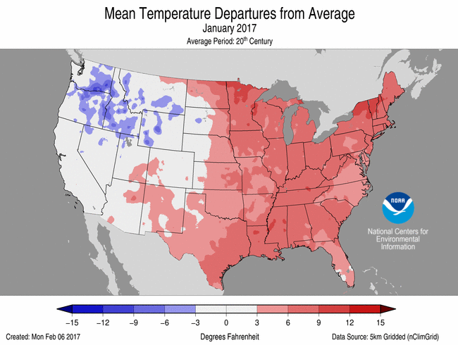 January Average Temperature Departures |
 January Percent of Average Precipitation |
- Climate Highlights — January
Temperature
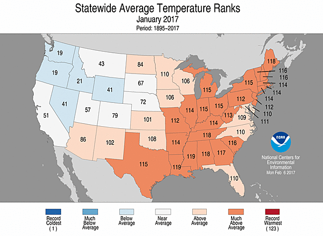
- The contiguous U.S. average January temperature was 33.6°F, 3.5°F above the 20th century average. This ranked as the 18th warmest January in the 123-year period of record.
- Most locations from the Rockies to the East Coast were warmer than average with 24 states across the Southeast, Midwest and Northeast much warmer than average.
- Most of the Northwest and Northern Rockies were cooler than average.
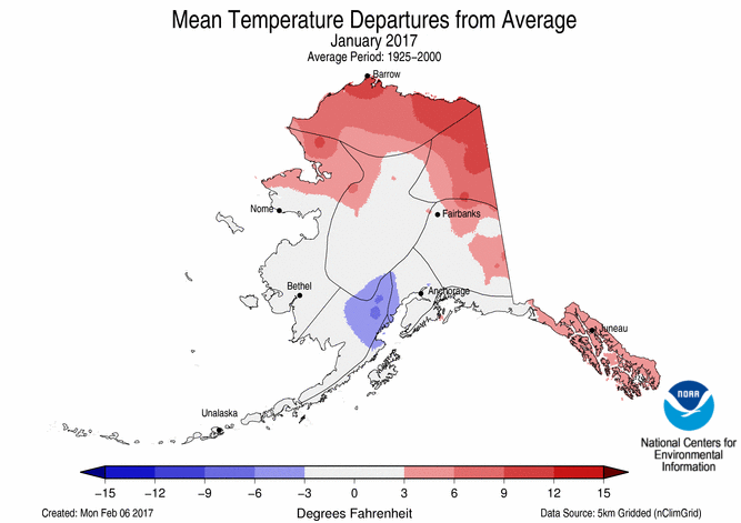
- The Alaska January temperature was 4.3°F, 1.9°F above the 20th century average. This ranked near the median value in the 93-year period of record for the state and was also the coldest January for the state since 2012. Northern areas of Alaska, particularly along the Arctic Coast, were warmer than average, while most other regions had near- to below-average temperatures.
- The contiguous U.S. average maximum (daytime) temperature during January was 42.9°F, 2.4°F above the 20th century average, the 31st warmest on record. Above-average maximum temperatures were observed for most locations east of the Rockies with much-above-average maximum temperatures in the Southeast, central Great Lakes, and Northeast. Below-average maximum temperatures were observed across the West and in the Northern Rockies.
- The contiguous U.S. average minimum (nighttime) temperature during January was 24.4°F, 4.6°F above the 20th century average, the eighth warmest on record. Above-average minimum temperatures were observed for most locations from the Rockies to East Coast, with 32 states in the Southern Plains and from the Mississippi River to East Coast were much warmer than average. Parts of the Northwest and Northern Rockies hadbelow-average minimum temperatures.
- During January there were 5,849 record warm daily high (2,299) and low (3,550) temperature records, which is more than two and a half times the 2,318 record cold daily high (1,266) and low (1,052) temperature records.
- Based on NOAA's Residential Energy Demand Temperature Index (REDTI), January 2017 ranked ninth lowest in the 123-year record for January, due to much-warmer-than-normal temperatures across the densely populated Midwest and Northeast.
January-January 2017 Statewide Temperature and Precipitation ranks
Precipitation
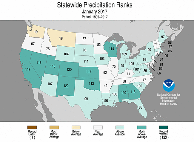
- The national January precipitation total was 3.18 inches, 0.87 inch above the 20th century average. This was the ninth wettest January on record and wettest since 1998.
- Large areas of the contiguous U.S. were wetter than average in January. Much-above-average precipitation was observed across the Southwest, Southern Plains, Midwest and Southeast. Ten states had much-above-average January precipitation. Below-average precipitation was observed across parts of the Northwest and Mid-Mississippi Valley. No state was record wet or dry in January.
- According to the January 31 U.S. Drought Monitor report, 14.6 percent of the contiguous U.S. was in drought, down from 22.5 percent at the beginning of the month. Drought improved by several categories across California and Nevada where a series of Pacific storms dumped significant amounts rain and snow. Despite the heavy precipitation, multi-year precipitation deficits persist. Drought also improved across parts of the Southern Plains, Southeast and Northeast. For the first time since March 2011, no location in the country was experiencing Exceptional Drought (D4), the worst category.
- Most locations across Hawaii were drier than average in January with abnormally dry conditions expanding to 55 percent of the state. Lihue, on Kauai, had its driest January on record with 0.20 inch of rain, only 5 percent of average. Reliable records in Lihue date back to 1905.
- According to an analysis of NOAA data by the Rutgers Global Snow Lab, the January contiguous U.S. snow cover extent was 1.51 million square miles, 148,000 square miles above the 1981-2010 average, and the 13th largest in the 51-year period of record. Above-average snow cover was observed across the West, Northern Plains, and Mid-Atlantic, with below-average snow cover in parts of the Southern Plains and Midwest.
Significant Events
- A strong storm system swept through the Southeast during January 20-22, spawning tornadoes from Texas to South Carolina. There were over 80 preliminary tornado reports, although the confirmed final count will likely be lower. Southern Georgia and Mississippi were the hardest hit areas with over 20 tornado-related fatalities. The deadliest single tornado from the event was an EF-3 that tracked 24 miles across southern Georgia, killing 11 people.
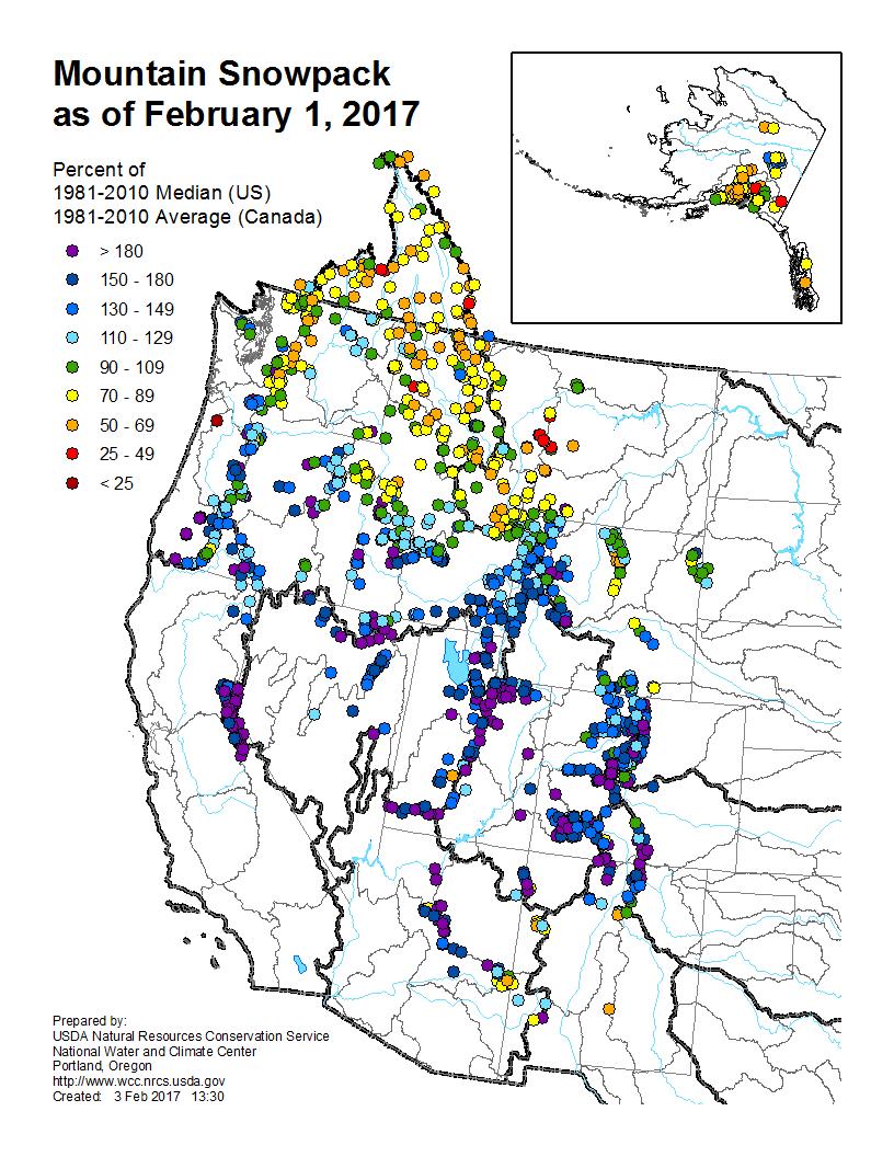
- A series of Pacific storms slammed into the West Coast during January. While the storms provided much needed drought relief for California and Nevada, the heavy precipitation caused widespread flooding and mudslides. The huge amounts of snow also increased the avalanche threat. A single storm early in the month dropped over 10 feet of snow on the California mountains. According to the USDA, as of February 1, mountain locations across California, Nevada, Oregon, Utah, Arizona and Colorado had snowpack totals more than 180 percent of normal.
**A comparison of the national temperature departure from average as calculated by NCDC's operational dataset (nClimDiv), the U.S. Historical Climatology Network (USHCN), and the U.S. Climate Reference Network (USCRN) is available on our National Temperature Index page.**
Regional Highlights:
These regional summaries were provided by the six Regional Climate Centers and reflect conditions in their respective regions. These six regions differ spatially from the nine climatic regions of the National Centers for Environmental Information.
- Northeast Region: (Information provided by the Northeast Regional Climate Center)
- January 2017 was the ninth month in a row the Northeast was warmer than normal. The region's monthly average temperature of 30.0 degrees F (-1.1 degrees C) was 6.8 degrees F (3.8 degrees C) above normal, making it the ninth warmest January since 1895. All twelve Northeast states experienced above-normal temperatures ranging from 5.0 degrees F (2.8 degrees C) above normal in Delaware to 8.5 degrees F (4.7 degrees C) above normal in Vermont. In addition, all twelve states ranked this January among their top 20 warmest on record: Maine, sixth warmest; New Hampshire and Vermont, eighth warmest; New York, ninth warmest; Connecticut, Massachusetts, and Rhode Island, 10th warmest; West Virginia, 11th warmest; New Jersey and Pennsylvania, 12th warmest; Maryland, 13th warmest; and Delaware, 14th warmest. Bridgeport, CT had its warmest January on record.
- The Northeast received 3.67 inches (93.22 mm) of precipitation, 118 percent of normal, in January. Seven states were wetter than normal, with precipitation ranging from 108 percent of normal in New Jersey to 147 percent of normal in West Virginia. For the five drier-than-normal states, precipitation ranged from 84 percent of normal in Vermont to 98 percent of normal in Maryland.
- The U.S. Drought Monitor released on January 5 indicated 44 percent of the Northeast was in a moderate, severe, or extreme drought, with another 26 percent being abnormally dry. Drought and abnormally dry conditions lingered, but slowly eased during January. Extreme drought continued in western portions of Massachusetts and Connecticut. Severe drought eased in eastern Massachusetts, New York's Long Island, northern New Jersey, and eastern Pennsylvania. Moderate drought eased in eastern Maine, the New York City metro area and central New Jersey. Abnormal dryness eased in northern and central New York, portions of Pennsylvania, west Maryland, and West Virginia. However, abnormal dryness expanded in southern Delaware and eastern Maryland. The U.S. Drought Monitor released on January 26 indicated 41 percent of the Northeast was in a moderate, severe, or extreme drought, with another 20 percent being abnormally dry. January average streamflow ranged from much below normal to much above normal, with many areas near normal. Groundwater levels remained near to below normal for a majority of the drought-stricken areas. While water levels in many reservoirs continued to increase slowly, they also generally remained below normal capacity. For instance, on January 3, the New York City reservoir system was at 65.4 percent of capacity compared to its normal capacity of 87.4 percent. By January 31, the system had increased to 76.9 percent of capacity, but was still below its normal capacity of 87.7 percent. Effective January 1, northeastern Massachusetts improved from a Drought Warning to a Drought Watch. Aquarion asked its water users in Connecticut to reduce indoor use by 20 percent. On January 18, the Delaware River Basin Commission lifted the drought watch for the basin, returning it to normal status. Worcester, Massachusetts' drought status improved to a Drought Warning effective January 23. The city had been under a Drought Emergency since September 2016. The Emergency Declaration issued for Ipswich, MA in mid-September due to a water supply shortage was terminated on January 26 because the town's water supply had recharged. The combined storage of twelve reservoirs operated by four water suppliers that serve northeastern New Jersey, the most densely populated part of the state, was around 80 percent of capacity, or near normal, as of January 30.
- Up to 46 inches (117 cm) of snow fell east of Lakes Erie and Ontario during a lake-effect snow event from January 4 to 8. The southern suburbs of Buffalo, New York were severely impacted on the 5th. More than two feet (61 cm) of snow fell in six to eight hours. With snowfall rates of 4 to 5 inches (10 to 13 cm) per hour during evening rush hour, snow quickly accumulated on roads. Traffic was at a standstill due to closed roads, accidents, and stuck or abandoned vehicles. For some, commutes lasted six or more hours. The conditions also caused hundreds of children to be stranded at school or on buses. From January 7 to 8, a nor'easter dropped up to 20 inches (51 cm) of snow on southern and coastal parts of the region, with the greatest amounts in eastern Delaware, eastern Long Island, Rhode Island, and southeastern Massachusetts. The storm contributed to a 20-vehicle pileup on Interstate 91 in Connecticut. Nearly 700 flights were delayed or cancelled at four of the region's major airports (Newark, Kennedy, LaGuardia, and Boston), with a ground stop reported at Philadelphia's airport. Another nor'easter brought mixed precipitation to the region from January 23 to 25. Up to 9 inches (23 cm) of snow and sleet, 0.5 inches (1.3 cm) of ice, and 3.67 inches (93 mm) of rain accumulated. Wind gusts of up to 69 mph (31 m/s) downed trees and wires and caused tens of thousands of power outages. The wind and rough surf severely eroded beaches and caused coastal flooding. Air, road, and rail travel was disrupted by the storm. On January 30, snow squalls contributed to several multi-vehicle accidents in Pennsylvania, including a crash on Interstate 83 involving more than 50 vehicles and a 20-vehicle pileup on Interstate 80.
- For more information, please go to the Northeast Regional Climate Center Home Page.
- Midwest Region: (Information provided by the Midwest Regional Climate Center)
- January temperatures were above normal across the Midwest ranging from 2 degrees F (1 C) to 8 degrees F (4 C) above normal. Departures from normal generally increased from northwest to southeast across the region. Statewide temperatures ranged from 4.5 degrees F (2.5 C) above normal in Wisconsin to 7.3 degrees F (4.1 C) above normal in Kentucky. Six Midwest states ranked among the warmest 10 percent (top 12) of their 1895 to 2017 history. The region as a whole averaged 5.5 degrees F (3.1 C) above normal which ranked as the 9th warmest January on record. Temperatures were below normal early in the month with readings in northern Minnesota on the 7th dropping to below -35 degrees F (-37 C). Just a few days later on the 11th, temperatures exceeded 70 degrees F (21 C) in Missouri. Temperatures also topped this threshold in Illinois, Indiana, and Kentucky later in the month. Although record low daily temperatures were reported just a few dozen times, record high daily temperatures were common during the middle two months of January. More than 400 record high maximum temperatures, and more than 1200 record high minimum temperatures, were recorded during the month.
- January precipitation totals ranged from 0.50 inches (13 mm) in western Minnesota to more than 5.00 inches (127 mm) in central Kentucky. As a percentage of normal, values ranged from less than 75 percent of normal in parts of Minnesota, Missouri, and Illinois to more than 200 percent of normal in large parts of the upper Midwest. Statewide, Wisconsin ranked as the 9th wettest January in its history (1895-2017) with 182 percent of normal and only Missouri was below normal at 90 percent of normal. The region as a whole received 129 percent of normal which ranked as the 27th wettest January in history. Snowfall in January was below normal for much of the region with above-normal areas limited to the northern third of the region. Totals less than 5 inches (13 cm) covered the southern two-thirds of the region and totals exceeding 20 inches (51 cm) were limited to parts of northern Michigan. Seasonal snow totals were also mostly below normal. In western Upper Michigan, snow deficits in some areas topped 4 feet (122 cm).
- Drought was a limited concern in January. The month began and ended with less than 2 percent of the region in drought. Although the area swelled to nearly 9 percent mid-month, few impacts were noted as vegetative demand and evaporation were low and rain that fell was soaked into unfrozen soils.
- Severe weather was reported in the region on just three days, the 3rd, 10th, and 12th. The busiest day was the 10th when strong winds damaged trees and power poles across several states. On the 3rd, a single report of large hail came from east central Illinois. Eastern Ohio, and areas extending eastward outside the Midwest, were affected by strong winds that again damaged trees.
- Freezing rain started on the 13th as a stationary front stalled across the southern Midwest. Missouri was hardest hit with ice accumulations up to 0.75 inches (19 mm). Through the 17th the storm gradually headed north bring ice accumulations as far north as northeastern Minnesota and southern Wisconsin.
- Although snow totals were less than normal for much of the region, two large events brought snowfall totals of around 12 inches (30 cm). The first was on the 10th, affecting much of Minnesota, northern Wisconsin, and Upper Michigan with the heaviest snow in the eastern parts of the affected area. The other began in northern Iowa on the 24th where the heaviest snows fell and moved eastward to Lower Michigan through the 26th.
- For further details on the weather and climate events in the Midwest, see the weekly and monthly reports at the Midwest Climate Watch page.
- Southeast Region: (Information provided by the Southeast Regional Climate Center)
- Temperatures were well above average across the Southeast region, with numerous extremes observed during January. Mean temperature departures ranged from 3 to 10 degrees F (1.7 to 5.6 degrees C) above average across much of the region, with the greatest departures located in Alabama and portions of Georgia, South Carolina, the Florida Panhandle, and southwestern Virginia. At least 33 long-term (i.e., period of record equaling or exceeding 50 years) stations across the region observed January mean temperatures that were ranked within the top 5 warmest values on record. The persistence of daytime and nighttime warmth was exceptional for many locations during the month. On three consecutive days (2nd, 3rd, and 4th), Plant City, FL (1893-2017) tied its highest daily maximum temperature on record for January, at 88 degrees F (31.1 degrees C). Miami, FL (1896-2017) recorded its second highest count of 6 days during January with a maximum temperature at or above 85 degrees F (29.4 degrees C). Several locations observed their longest streak of days during January with a maximum temperature at or above 75 degrees F (23.9 degrees C), including Augusta, GA (1875-2017; 10 days), Montgomery, AL (1873-2017; 10 days), Mobile, AL (1873-2017; 11 days), and Pensacola, FL (1880-2017; 10 days). Macon, GA (1900-2017), Columbus, GA (1899-2017), and Atlanta, GA (1879-2017) recorded their longest streak of days during January with a maximum temperature of at least 70 degrees F (21.1 degrees C), at 11, 10, and 9 days, respectively. Washington, D.C. (1872-2017) and Richmond, VA (1897-2017) observed their longest streak of days during January with a minimum temperature above 32 degrees F (0 degrees C), at 19 and 17 days, respectively. Temperatures were closer to normal across Puerto Rico and the U.S. Virgin Islands during the month, ranging from 2 degrees F (1.1 degrees C) below average to 1 degree F (0.6 degrees C) above average. Across the Southeast, the warmest weather of the month occurred on the 12th and 13th, as unseasonably warm, moist air surged northward ahead of a cold front. Daytime maximum temperatures exceeded 70 degrees F across much of the region, with several locations across the southern portion of the region reaching the lower 80s F (26.7 to 28.3 degrees C). In contrast, the coldest weather of the month occurred on the 8th and 9th, as a strong Arctic high pressure system ushered in unusually cold air from the northwest. Nighttime minimum temperatures fell below 25 degrees F (-3.9 degrees C) across much of the region north of Florida, but the coldest air was confined to areas with a fresh snowpack in North Carolina and Virginia, where numerous locations reached -5 to 10 degrees F (-20.6 to -12.2 degrees C). From the 8th through the 10th, Salisbury 9 WNW, NC (1955-2017) and John H. Kerr Dam, VA (1949-2017) observed their third and fifth lowest 3-day average minimum temperature for any month on record, at 1.7 and 4.0 degrees F (-16.8 and -15.6 degrees C), respectively.
- Precipitation ranged from near normal to above normal across much of the Southeast, with several extremes recorded. The wettest locations were found across portions of central and southern Alabama, central and southern Georgia, west-central South Carolina, and the Florida Panhandle. Monthly precipitation totals were 3 to more than 8 inches (76.2 to more than 203 mm) above normal in these areas. Macon, GA (1894-2017) and Augusta, GA (1872-2017) observed their second wettest January on record, with 11.26 and 10.13 inches (286 and 257 mm) of precipitation, respectively. Columbus, GA (1893-2017) observed its third wettest January on record, with 11.48 inches (292 mm) of precipitation. Over half of the monthly totals for Macon and Columbus were recorded in the first two days of the month. Macon observed its fourth wettest two-day period for any month on record, with 6.60 inches (168 mm) of precipitation. Columbus observed its seventh wettest two-day period for any month on record, with 6.78 inches (172 mm) of precipitation. On the 22nd, Glennville, GA (1905-2017) and Savannah, GA (1871-2017) observed their wettest January day on record, with 5.45 and 4.19 inches (138 and 106 mm) of precipitation, respectively. From the 6th through the 7th, a winter storm produced snow, sleet, and freezing rain across a widespread portion of the region, with near-blizzard conditions occurring in coastal Virginia. A broad swath of 3 to more than 12 inches (76.2 to more than 305 mm) of snowfall was observed across much of northeastern Georgia, Upstate South Carolina, western and north-central North Carolina, and central and southern Virginia. The highest snowfall accumulations by state were recorded at the following CoCoRaHS stations: 6.6 inches (168 mm) at Hiawassee 4.8 SSE, GA, 6.2 inches (157 mm) at Travelers Rest 7.6 N, SC, 13.5 inches (343 mm) at Norlina 5.0 N, NC, and 13.3 inches (338 mm) at Port Haywood 1.0 SE, VA. Wallops Island, VA (1967-2017) tied its second highest 1-day snowfall for any month on record, with 10.0 inches (254 mm) on the 7th. Tryon, NC (1917-2017) observed its second highest 1-day snowfall on record for January, with 10.0 inches on the 7th. Freezing rain accumulations up to three-tenths of an inch (7.6 mm) were observed in the Atlanta metropolitan area, while sleet accumulations of 0.5 to 1 inch (12.7 to 25.4 mm) were recorded at multiple locations in the Birmingham, AL and Raleigh-Durham, NC metropolitan areas. The highest monthly snowfall total recorded in the region was 43.7 inches (1,110 mm) on Mt. Mitchell, NC (1980-2017), which is nearly double its average for January (22.1 inches; 561 mm). Monthly precipitation totals were 1 to 4 inches (25.4 to 102 mm) above normal in portions of central and western Puerto Rico but were 1 to 4 inches below normal in parts of eastern Puerto Rico and the U.S. Virgin Islands.
- There were 379 severe weather reports across the Southeast during January, which is more than six times greater than the median monthly frequency of 61 reports during 2000-2015. Nearly all of the reports (367 of 379) were recorded in Alabama, Georgia, and Florida during the month, and the majority of these reports (360 of 367) were associated with two severe weather outbreaks on the 2nd and the 21st through the 23rd. Strong thunderstorm winds accounted for over 70 percent (273 of 379) of all severe weather reports during January and caused six fatalities across the region. On the 2nd, thunderstorm wind gusts estimated at 70 to 80 mph caused significant damage to several homes and commercial buildings in Gulf Shores, AL, with 1 injury reported when a sunroom collapsed onto an elderly woman. Damage to trees, fencing, and wildlife enclosures occurred at the Alabama Gulf Coast Zoo, but all of the animals survived. Later that day, thunderstorm wind gusts estimated at 85 mph caused a large tree to fall onto a mobile home near Rehoboth, AL, killing four people inside. On the 22nd and 23rd, thunderstorm wind gusts ranging from 50 to more than 70 mph were recorded at numerous locations across the southern portion of the region, including a 75 mph gust at Birmingham International Airport in Alabama. A total of 77 tornadoes (23 EF-0s, 42 EF-1s, 10 EF-2s, 2 EF-3s) were confirmed during the month, which is the greatest January tornado count for the region since modern records began in 1950. In fact, this count is more than double the previous monthly record of 29 tornadoes recorded in January 2006. Over 80 percent (63 of 77) of the tornadoes occurred during a multi-day severe weather outbreak from the 21st through the 23rd, connected with the development of an exceptionally strong mid-latitude cyclone. Indeed, nearly every major city in Florida observed their lowest mean sea level pressure on record for January, including Tallahassee (989.8 mb), Orlando (995.6 mb), and Miami (999.7 mb). Over half (41 of 63) of the tornadoes in this outbreak, including four EF-2s and two EF-3s, occurred in Georgia, which set new state records for the most tornadoes recorded in a single day (27) and two-day period (41). The two EF-3 tornadoes caused 16 fatalities in southern Georgia on the 22nd, which is more than double the number of January tornado fatalities recorded in the state from 1950 to 2016 (6). It is also nearly as much as the nationwide tornado fatality count during all of 2016 (17). During the early morning of the 22nd, an EF-3 tornado tracked nearly 25 miles across three counties in south-central Georgia, resulting in 11 fatalities. Six well-built homes sustained major damage, and over 35 mobile homes were destroyed. Later that afternoon, another EF-3 tornado, with a maximum width of 1.25 miles, tracked over 70 miles across four counties in southwestern Georgia. Dozens of homes and other structures were damaged or destroyed, and 90 to 100 percent of trees were uprooted or snapped in many locations along its path. Five fatalities were reported in Albany, GA, and at least 40 people were injured. Two people were injured by lightning strikes during the month.
- Drought conditions improved significantly across the interior portion of the region during January. The coverage of extreme-to-exceptional (D3-D4) drought across the Southeast decreased from 21 percent on December 27th to 1 percent on January 31st. Exceptional drought conditions were completely removed from the region, and only two small areas of extreme drought remained in portions of central Alabama and northeastern Georgia. In addition, moderate-to-severe (D1-D2) drought was significantly reduced or removed across broad portions of the region, including central and southern Alabama, central and southern Georgia, the Florida Panhandle, the western Carolinas, and northern and southwestern Virginia. Despite the beneficial rainfall across the interior portion of the region, streamflow and lake levels remained slow to recover in some areas from the long-term effects of the drought. Warmer-than-average temperatures and more consistent rainfall improved pasture conditions in Alabama, Georgia, and the western Carolinas. However, livestock producers continued to purchase hay for their herds since the pastures had not recovered enough to support cattle grazing. Fruit and vegetable crops in some areas were behind on chilling hours due to the unusual warmth during the month, with blueberry plants in Georgia and Florida already beginning to bud. Rather than focusing on field preparation for spring planting, many farmers in central and southern Georgia had to clean up debris caused by severe thunderstorms, which damaged agricultural equipment, irrigation pivots, grain bins, pecan orchards, and pine timber.
- For more information, please go to the Southeast Regional Climate Center Home Page.
- High Plains Region: (Information provided by the High Plains Regional Climate Center )
- Much of the High Plains experienced wet conditions during January, as precipitation was greater than 200 percent of normal across parts of Wyoming, Colorado, Nebraska, and Kansas. This wetness led to some records across the region. For instance, Alamosa, Colorado and Dodge City, Kansas had their wettest January on record, and it was the snowiest January for Alamosa and Riverton, Wyoming. Snowfall was ample across the Rockies, which boosted snowpack but caused ski resorts to close. Farther east, heavy rain fell across parts of Kansas, with some locations receiving more than double their normal monthly precipitation total in one day. This abundant rainfall helped ease drought conditions in the region. Heavy precipitation and large changes in drought conditions in the High Plains are rare for this time of year.
- Temperatures were cooler than normal in the western High Plains, while the eastern High Plains and western Colorado experienced slightly above-normal temperatures. While temperatures were not record-breaking in January, they had an impact on the type of precipitation that fell in the region. Several places that ordinarily get snowfall in January got rain or freezing rain instead, as was the case in parts of Colorado and Nebraska. Ice storm warnings were issued, which are not common in these areas in January. Some locations around the region have received a greater-than-normal proportion of precipitation falling as rain instead of snow during this snow season. For example, Lincoln, Nebraska had its 4th least snowiest October-January period on record, despite total precipitation for that period being slightly above normal.
- During the winter, producers in the High Plains region monitor the weather conditions closely for winter wheat. According to the U.S. Department of Agriculture, farmers in western Kansas and eastern Colorado have been concerned about winter wheat stands due to dry conditions in the fall, which has caused growth to fall behind. Also, a lack of snow cover has left the crop vulnerable during outbreaks of Arctic air. As of the end of January, the majority of the winter wheat crop in Kansas and Colorado was in fair or good condition.
- The High Plains region was caught in the middle of a rather impressive temperature gradient across the country in January. Temperatures were much above-normal in the eastern U.S., while below-normal temperatures were prevalent in the West. The High Plains followed a similar pattern in that the western part of the region was cooler than normal, while it was warmer than normal in the eastern portion. Temperatures ranged from approximately 9.0 degrees F (5.0 degrees C) below normal to 5.0 degrees F (2.8 degrees C) above normal across the area. Locations that were especially cooler than normal included Wyoming and the western Dakotas. While temperature departures were rather impressive in these areas, this part of the region did not see the record-breaking cold that was experienced in December. Meanwhile, the greatest above-normal temperature departures occurred in eastern North Dakota and eastern Kansas.
- Cooler conditions were widespread across the region during the first half of January. An impressive Arctic air mass moved through during the 6th-7th, which brought the coldest temperatures of the month for a large part of the region. Bitterly cold temperatures of -20.0 degrees F (-28.9 degrees C) and below were prevalent in North Dakota and Wyoming. The temperature plummeted to an astounding -40.0 degrees F (-40.0 degrees C) in Laramie, Wyoming on the 6th, which was the 5th coldest temperature on record at that location (period of record 1948-2017). In fact, Wyoming Highway Patrol urged motorists to not travel unnecessarily on Interstate 80 and several other highways in the state due to the cold, which is rather rare according to the NWS in Cheyenne.
- January was a wet month across much of the High Plains, as precipitation exceeded 200 percent of normal throughout much of Nebraska, Kansas, Wyoming, and Colorado. Heavy snow blanketed the Rockies, further boosting snowpack that had already begun to build rapidly due to a wet December. Meanwhile, rain and freezing rain contributed to the wetness experienced in Kansas and southern Nebraska.
- Snowfall was quite impressive throughout the Rockies of Colorado and Wyoming in January. For instance, Alamosa, Colorado had its wettest and snowiest January on record. Alamosa received 21.9 inches (56 cm) of snow, shattering the previous record of 15.8 inches (40 cm) set in January 1939. In fact, it snowed so much in parts of Colorado, ski resorts closed due to too much snow. According to Channel 9 News in Denver, heavy, wet snow that accumulated quickly prompted Crested Butte and Monarch Mountain ski resorts to close because of avalanche concerns. Crested Butte received an astonishing 101.8 inches (259 cm) of snow, which was its 4th snowiest January on record (period of record 1910-2017). In Wyoming, it was also quite snowy. For instance, the Riverton COOP station experienced its snowiest January on record. According to the National Weather Service (NWS) in Riverton, the snow depth at Riverton on the 24th was 17.0 inches (43 cm), which was Riverton's second highest snow depth on record.
- One event that was particularly impactful in the region was the ice storm that affected southeastern Nebraska and a large part of Kansas on the 14th-16th. An upper-level storm system, combined with a warm and moist low-level air mass overriding colder air at the surface, created a widespread freezing rain event that crippled travel and downed trees and power lines throughout the region. According to the NWS in Topeka, ice accumulations were greatest in southwestern Kansas, where 1.00 inches (3 cm) of ice accumulated in and around the Dodge City area. Impressive precipitation totals occurred with this storm as well. On the 15th, Dodge City received 1.41 inches (36 mm) of rain, setting a record for highest 1-day total precipitation for the month of January. Dodge City only averages 0.58 inches (15 mm) of precipitation in January. In Nebraska, ice accumulations were highest in Fairbury at 0.75 inches (2 cm). The NWS in Omaha stated that this storm event was unusual for southeastern Nebraska because the predominant form of precipitation was freezing rain rather than snow.
- As of the end of January, snowpack was generally above normal throughout the Rockies in Colorado and Wyoming, thanks to a continuation of wet conditions since December. January precipitation was at least 200 percent of normal in these areas, and near-normal to below-normal temperatures helped preserve the snowpack. According to the U.S. Army Corps of Engineers, Snow Water Equivalent (SWE) above Fort Peck Dam was 76 percent of average at the end of January, which was a slight decrease from the previous month but was faring better than 2001, the lowest snowpack year of the last 20-year period. Snowpack continued to improve between Fort Peck and Garrison Dams, as SWE increased slightly to 108 percent of average. Normally by February 1, about 64 percent of the peak mountain SWE has occurred in both reaches.
- Overall, drought conditions improved throughout the High Plains in January. It was a wet month, as many areas received greater than 200 percent of normal precipitation, which was quite beneficial in drought-stricken areas. Region-wide, the area in drought (D1-D4) on the U.S. Drought Monitor decreased from about 22 percent to 19 percent, and the area experiencing drought or abnormal dryness (D0-D4) improved from approximately 49 percent to 38 percent.
- One area that saw significant improvement of drought conditions during January was the Black Hills region of South Dakota. According to the January 31st U.S. Drought Monitor author, severe drought (D2) improved to moderate drought (D1) in the Black Hills due to wet conditions during the past 30-90 days. SNOTEL stations in the region were reporting near-normal Snow Water Equivalent (SWE) values. This particular area has been dealing with drought conditions since early summer.
- Another area that experienced drought relief was in Kansas. Southern areas of the state received impressive rains in January that led to the trimming of D2 conditions, while abnormally dry conditions (D0) were removed from central Kansas. Improvements made were primarily due to heavy precipitation that fell as part of the major storm system that moved through in the middle part of the month. Drought conditions also improved in southeastern Wyoming, central Nebraska, and eastern Colorado.
- For more information, please go to the High Plains Regional Climate Center Home Page.
- Southern Region: (Information provided by the Southern Regional Climate Center)
- January was a warmer than normal month for all six states in the Southern Region. In fact, the temperature rankings for each state were all in the top ten, with the exception of Oklahoma. For the region as a whole, it was the eighth warmest January on record. Temperatures generally averaged between 6 to 8 degrees F ( 3.33 to 4. 44 degrees C) above normal in Louisiana, Mississippi and Tennessee. Elsewhere, temperatures ranged between 2 to 4 degrees F (1.11 to 2.22 degrees C ) above the monthly normal. The statewide monthly average temperatures were as follows: Arkansas reporting 45.30 degrees F (7.39 degrees C), Louisiana reporting 57.00 degrees F (13.89 degrees C), Mississippi reporting 52.90 degrees F (11.61 degrees C), Oklahoma reporting 40.80 degrees F (4.89 degrees C), Tennessee reporting 45.00 degrees F (7.22 degrees C), and Texas reporting 50.80 degrees F (10.44 degrees C). The state-wide temperature rankings for January are as follows: Arkansas (tenth warmest), Louisiana (fifth warmest), Mississippi (fifth warmest), Oklahoma (sixteenth warmest), Tennessee (sixth warmest), and Texas (ninth warmest). All state rankings are based on the period spanning 1895-2017.
- Precipitation values for the month of January varied spatially across the Southern Region. Precipitation totals in western Texas and western Oklahoma ranged between 130 to over 200 percent of normal. By contrast, conditions were quite dry across much of eastern Oklahoma and Arkansas, with most stations reporting between 25 to 70 percent of normal. Along the gulf coasts of Louisiana and eastern Texas, precipitation values were as expected for the month, ranging between 90 to 110 percent of normal. This was also the case in eastern Tennessee. The state-wide precipitation totals for the month are as follows: Arkansas reporting 3.03 inches (76.96 mm), Louisiana reporting 6.41 inches (162.81 mm), Mississippi reporting 7.06 inches (179.32 mm), Oklahoma reporting 2.58 inches (65.53 mm), Tennessee reporting 4.22 inches (107.19 mm), and Texas reporting 2.31 inches (58.67 mm). The state precipitation rankings for the month are as follows: Arkansas (forty-ninth driest), Louisiana (twenty-eighth wettest), Mississippi (twenty-first wettest), Oklahoma (eleventh wettest), Tennessee (fifty-eighth driest), and Texas (twenty-fifth wettest). All state rankings are based on the period spanning 1895-2017.
- Over the month of January, 2017, drought conditions improved in some areas, but worsened in others. In Mississippi, anomalously high precipitation totals helped eradicate drought in most of the northern counties. This was also the case in northern Louisiana. Elsewhere, drought conditions did not change significantly.
- On January 1, 2017, a wind gust of 82 miles per hour (131.97 kilometers per hour) was reported in Hamilton County, Texas. Wind damage was reported in Coryell, Mclennan and Pecos Counties.
- On January 2, 2017, many tornadoes were reported across the southern states of Louisiana and Mississippi. Fortunately, there were no injuries or fatalities reported in the Southern Region. In Louisiana, ten to fifteen homes were reported damaged in Beauregard Parish. Several homes were also damaged in Evangeline, Rapides, and Avoyelles Parishes. Damage was also reported in the southern counties of Mississippi, however, most damage was limited to trees and power lines.
- On January 15-16, 2017, several tornadoes were reported in central Texas. Three homes were damaged on the sixteenth of the month in Harris County.
- On January 20, 2017, four tornadoes touched down in southern Mississippi. Four fatalities and fifty-six injuries were reported in Lamar County. One other person was injured in Perry County. Extensive damage was reported in Forrest County and in Perry County.
- On January 21, 2017, more tornadoes were reported as part of an outbreak in which dozens of twisters touched down from Texas across the southern states into Georgia and South Carolina. In Louisiana, three people were injured. One injury was reported in Bossier Parish, another in Natchitoches Parish and the third in Grant Parish. In Bossier Parish, structural damage was reported as multiple mobile homes were rolled and destroyed. This was the result of an EF2 tornado. Another EF2 was also reported near Natchitoches Parish. In Texas, damage was mostly restricted to trees and power lines. In Mississippi, one person was reported injured in Lauderdale County from an EF2 tornado that tracked 7.3 miles (11.75 kilometers) and was estimated to be approximately 550 yards (502.92 meters) wide.
- For more information, please go to the Southern Regional Climate Center Home Page.
- Western Region: (Information provided by the Western Region Climate Center)
- A progressive storm track featuring several moderate to strong atmospheric rivers produced impressive precipitation totals across the southern two-thirds of the West. In contrast, the northern tier of the region generally saw below normal precipitation. Temperatures were below normal across the Northwest, slightly above normal in New Mexico and the Four Corners region, and near normal elsewhere.
- Storms impacting the West this month brought beneficial precipitation to drought stricken areas of California and Nevada, as well as damaging floods, travel disruptions, and avalanche hazards. In the coastal mountains of northern California, Venado observed 48.83 in (1240 mm) of precipitation this month, 417% of normal. This shattered the previous monthly record of 29.88 in (759 mm) set in December 2002. Records for Venado began in 1948. Sierra Nevada snowfall was well above normal; Tahoe City, California, observed 136 in (345 cm) of snowfall, the 4th snowiest January since records began in 1903. Orientation and characteristics of these storms favored moisture to penetrate inland and impact the Great Basin and Southwest. In northwestern Nevada, Reno recorded 5.57 in (141 mm), 540% of normal and set the record for wettest of any month in the station's history beginning in 1937. Further east, Pocatello, Idaho, reported 2.85 in (72 mm), 288% of normal and the 3rd wettest January since records began in 1939. Pocatello received 32.2 in (82 cm) of snowfall, the second highest of any month in the station's record. In the Southwest, Las Cruces, New Mexico, reported a total of 1.57 in (40 mm), 307% of normal and the 3rd wettest January since records began in 1892. In contrast, Washington, northern Idaho, northern Oregon, and much of Montana observed below normal precipitation. Seattle, Washington, reported 4.22 in (107 mm), 76% of normal.
- At the end of January, most major mountain areas of the West were reporting above normal snow water equivalent (SWE); some basins in the Sierra Nevada and central Rocky Mountains reported SWE in excess of 150% of normal. The exception was the northern Rockies and northern Cascades. Snowpack in these areas was generally <80% of normal. The above normal precipitation and healthy snowpack contributed to improvement of drought conditions across much of California and Nevada as depicted in the US Drought Monitor. Areas of California's South Coast that have been entrenched in extreme to exceptional drought since 2013 observed significant rainfall this month, improving conditions such that only a small area of extreme drought conditions remain. Los Angeles, for example, recorded 8.38 in (213 mm) for the month, 269% of normal and the 10th wettest January since records began in 1877. However, moderate to severe drought still covers nearly all of southern California due to long-term impacts. Areas of improvement were also noted in at least a small portion of all other contiguous western states.
- Cold air masses moved over the Northwest during the first half of the month, driving temperatures well below normal. Walla Walla, Washington, reported a monthly average of 22.2 F (-5.4 C), 13.3 F (7.4 C) below normal. This was the 5th coldest January in Walla Walla since records began in 1949. In Missoula, Montana, temperatures averaged to 13.8 F (-10.1 C), 12 F (6.7 C) below normal, the 6th coldest January in a 69-year record. In contrast, New Mexico and surrounding areas observed temperatures 0-4+ F (0-2+ C) above normal. Gallup, in northwestern New Mexico reported an average temperature of 32.4 F (0.2 C), 3.7 F (2 C) above normal.
- Drier than normal conditions were observed across much of the state of Hawaii this month, with the exception of some Big Island windward locations. Lihue, Kauai, had its driest January on record, reporting only 0.2 in (5 mm) of rainfall, 19% of normal. Records for Lihue began in 1950. The dry conditions prompted expansion of 'abnormally dry' in the US Drought Monitor from roughly 10% of the state at the beginning of the month to 54% of the state by the end of the month. In Alaska, temperatures were above normal in the northern third of the state and near to well below normal in the southern two-thirds. On the North Slope, Utqia'vik recorded an average temperature of -0.3 F (-17.9 C), 13.1 F (7.3 C) above normal, the 3rd warmest January in its 98-year record. In the Southcentral region, Kenai reported an average temperature of 9.1 F (-12.7 C), 7.3 F (4 C) below normal. Many locations across Alaska observed near to above normal precipitation. Utqia'vik reported 0.47 in (12 mm), 361% of normal. Further south, 1.71 in (43 mm) of precipitation fell in Anchorage, 234% of normal and the 3rd wettest January on record. This was also the 2nd snowiest January for Anchorage at 31.7 in (80.5 cm); records began in 1952. In the Southeast, precipitation was near normal, though much fell as rain rather than snow, continuing a trend of below normal snowfall seen in recent years.
- January 6-8: Major storm produces flooding, mudslides, and avalanches in northern California and western Nevada: A strong atmospheric river storm produced heavy rain on snow that contributed to flooding along the Truckee River and other waterways in the Sierra Nevada, northeastern California, and western Nevada. Over 1000 homes in the Reno area were evacuated and many commercial and residential areas saw minor to moderate flooding. Mudslides caused prolonged road closures on Interstate 80, Highway 17, and Highway 1 in northern California.
- January (all month): Snow-related hazards in the West: The storm sequence this month has been conducive to extreme avalanche danger in many areas of the West. Avalanches have closed roads in the Sierra Nevada several times this month, and three fatalities were reported across the West. Heavy snows and cold temperatures also caused building collapses in many locations in the West, impacting businesses and human safety.
- For more information, please go to the Western Regional Climate Center Home Page.