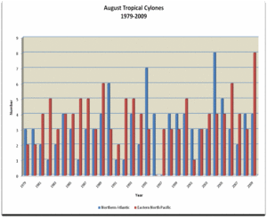
 August Tropical Cyclones |
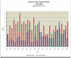 Season-to-Date Tropical Cyclones |
Atlantic Basin
The year-to-date North Atlantic tropical cyclone total is four. All four storms occurred during the month of August, which is slightly above the average of 3.2. On average, by the end of August, the Northern Atlantic harvests 5.1 named storms and the yearly average is 12.1. All averages are based on a 1979—2009 period.
The low year-to-date tropical cyclones could be the result of a variety of contributing factors, including El Nino. It has been documented that the warming of the Eastern Pacific Ocean can increase the vertical wind shear in the Northern Atlantic, thus suppressing tropical cyclone activity. The graphs above help illustrate these findings. According to the Climate Prediction Center, recent strong El Nino episodes have occurred in 1982—83, 1991—92, and 1997—98. Sources: Tropical Cyclones of the North Atlantic Ocean, 1851 - 2006 & Tropical Cyclones of the Eastern North Pacific Basin, 1949-2006
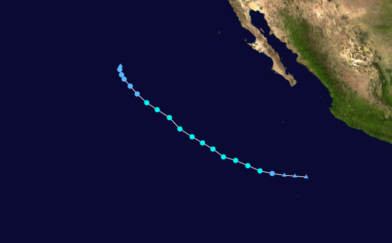
 Tropical Storm Ana Satellite Image |
 Tropical Storm Ana Track  Saffir-Simpson Scale Color Legend |
| Tropical Cyclone | Ana |
| Cyclogenesis Date | 08/11 |
| Cyclogenesis Date | 08/17 |
| Highest Saffir-Simpson Category | TS |
| Max Wind | 40mph (65 km/h) |
| Min Pressure | 1004 mbar |
More information on Ana is available from the NOAA National Hurricane Center.
 Hurricane Bill Satellite Image |
 Hurricane Bill Track Saffir-Simpson Scale Color Legend |
| Tropical Cyclone | Bill |
| Cyclogenesis Date | 08/15 |
| Cyclolysis Date | 08/26 |
| Highest Saffir-Simpson Category | Cat 4 |
| Maximum 6-hr Sustained Wind | 132 mph (212 km/h) |
| Min Pressure | 943 mbar |
| Accumulated Cyclone Energy (ACE) Index (kt2) | 27.7725 x 10⁴ |
| Landfall Information (date, location and sustained winds) | N/A |
| Deaths | 2 |
More information on Bill is available from the NOAA National Hurricane Center.
 Tropical Storm Claudette Satellite Image |
 Tropical Storm Claudette Track Saffir-Simpson Scale Color Legend |
| Tropical Cyclone | Claudette |
| Cyclogenesis Date | 08/16 |
| Cyclolysis Date | 08/17 |
| Highest Saffir-Simpson Category | TS |
| Maximum 6-hr Sustained Wind | 52 mph (83 km/h) |
| Min Pressure | 1006 mbar |
| Accumulated Cyclone Energy (ACE) Index (kt2) | .8900 x 104 |
| Landfall Information (date, location and sustained winds) | 08/17/09, Florida Panhandle near Fort Walton Beach, Florida, 52 mph |
| Deaths | 2 |
More information on Claudette is available from the NOAA National Hurricane Center.
 Tropical Storm Danny Satellite Image |
 Tropical Storm Danny Track Saffir-Simpson Scale Color Legend |
| Tropical Cyclone | Danny |
| Cyclogenesis Date | 08/26 |
| Cyclolysis Date | 08/28 |
| Maximum 6-hr Sustained Wind | 58 mph (93 km/h) |
| Min Pressure | 1006 mbar |
| Accumulated Cyclone Energy (ACE) Index (kt2) | 2.0581 x 10⁴ |
| Landfall Information (date, location and sustained winds) | N/A |
| Deaths | 1 |
More information on Danny is available from the NOAA National Hurricane Center.
Northeast Pacific Basin
August 2009, eight named storms spawned in the Eastern North Pacific (ENP) resulting in one of the most active Augusts on record. On average, 3.8 tropical cyclones form in the ENP during August and 2.2 of those became hurricanes. For the year-to-date period, there have been 13 named storms to form, five of which went on to become hurricanes. On average, there are typically ten named storms to form by the end of August and the annual average is 15.4. The 1992 ENP season was the most active as 27 named storms formed. All averages are based on a 1979—2009 period. The 2009 ENP season officially began on May 15th and ends November 30th.
 Tropical Storm Enrique Satellite Image |
 Tropical Storm Enrique Track Saffir-Simpson Scale Color Legend |
| Tropical Cyclone | Danny |
| Cyclogenesis Date | 08/03 |
| Cyclolysis Date | 08/07 |
| Maximum 6-hr Sustained Wind | 60 mph (95 km/h) |
| Min Pressure | 998 mbar |
| Accumulated Cyclone Energy (ACE) Index (kt2) | .9245 x 104 |
| Landfall Information (date, location and sustained winds) | N/A |
| Deaths | 1 |
More information on Enrique is available from the NOAA National Hurricane Center.
 Hurricane Felicia Satellite Image |
 Hurricane Felicia Track Saffir-Simpson Scale Color Legend |
| Tropical Cyclone | Felicia |
| Cyclogenesis Date | 08/03 |
| Cyclolysis Date | 08/11 |
| Maximum 6-hr Sustained Wind | 145 mph (230 km/h) |
| Min Pressure | 935 mbar |
| Accumulated Cyclone Energy (ACE) Index (kt2) | 18.4721 x 10⁴ |
| Landfall Information (date, location and sustained winds) | N/A |
| Deaths | 1 |
More information on Felicia is available from the NOAA National Hurricane Center.
 Hurricane Guillermo Satellite Image |
 Hurricane Guillermo Track Saffir-Simpson Scale Color Legend |
| Tropical Cyclone | Guillermo |
| Cyclogenesis Date | 08/12 |
| Cyclolysis Date | 08/19 |
| Higest Saffir-Simpson Category | Cat 3 |
| Maximum 6-hr Sustained Wind | 127 mph (110 kt or 203 km/h) |
| Min Pressure | 954 mbar |
| Accumulated Cyclone Energy (ACE) Index (kt2) | 11.3312 x 10⁴ |
| Landfall Information (date, location and sustained winds) | N/A |
| Deaths | 1 |
More information on Guillermo is available from the NOAA National Hurricane Center.
 Tropical Storm Hilda Satellite Image |
 Tropical Storm Hilda Track Saffir-Simpson Scale Color Legend |
| Tropical Cyclone | Hilda |
| Cyclogenesis Date | 08/22 |
| Cyclolysis Date | 08/26 |
| Higest Saffir-Simpson Category | TS |
| Maximum 6-hr Sustained Wind | 65 mph (100 km/h) |
| Min Pressure | 999 mbar |
| Accumulated Cyclone Energy (ACE) Index (kt2) | 3.0563 x 10⁴ |
| Landfall Information (date, location and sustained winds) | N/A |
| Deaths | 1 |
More information on Hilda is available from the NOAA National Hurricane Center.
 Tropical Storm Ignacio Satellite Image |
 Tropical Storm Ignacio Track Saffir-Simpson Scale Color Legend |
| Tropical Cyclone | Ignacio |
| Cyclogenesis Date | 08/24 |
| Cyclolysis Date | 08/27 |
| Higest Saffir-Simpson Category | TS |
| Maximum 6-hr Sustained Wind | 50 mph (85 km/h) |
| Min Pressure | 999 mbar |
| Accumulated Cyclone Energy (ACE) Index (kt2) | 1.7425 x 10⁴ |
| Landfall Information (date, location and sustained winds) | N/A |
| Deaths | 1 |
More information on Ignacio is available from the NOAA National Hurricane Center.
 Hurricane Jimena Satellite Image |
 Hurricane Jimena Track Saffir-Simpson Scale Color Legend |
| Tropical Cyclone | Jimena |
| Cyclogenesis Date | 08/29 |
| Cyclolysis Date | 09/04 |
| Higest Saffir-Simpson Category | Cat 4 |
| Maximum 6-hr Sustained Wind | 155 mph (250 km/h) |
| Min Pressure | 931 mbar |
| Accumulated Cyclone Energy (ACE) Index (kt2) | 23.0325 x 10⁴ |
| Landfall Information (date, location and sustained winds) | 09/02 - near Cabo San Lazaro, Mexico (104 mph) San Buenaventura, Mexico (85 mph) |
| Deaths | 2 |
More information on Jimena is available from the NOAA National Hurricane Center.
 Hurricane Kevin Satellite Image |
 Hurricane Kevin Track Saffir-Simpson Scale Color Legend |
| Tropical Cyclone | Kevin |
| Cyclogenesis Date | 08/29 |
| Cyclolysis Date | 08/31 |
| Higest Saffir-Simpson Category | TS |
| Maximum 6-hr Sustained Wind | 52 mph (83 km/h) |
| Min Pressure | 931 mbar |
| Accumulated Cyclone Energy (ACE) Index (kt2) | 1.1725 x 10⁴ |
| Landfall Information (date, location and sustained winds) | N/A |
| Deaths | 1 |
More information on Kevin is available from the NOAA National Hurricane Center.
 Tropical Storm Maka Satellite Image |
 Tropical Storm Maka Track Saffir-Simpson Scale Color Legend |
| Tropical Cyclone | Maka |
| Cyclogenesis Date | 08/11 |
| Cyclolysis Date | 08/11 |
| Higest Saffir-Simpson Category | TS |
| Maximum 6-hr Sustained Wind | 40 mph (35 kt or 65 km/h) |
| Min Pressure | 1007 mbar |
| Accumulated Cyclone Energy (ACE) Index (kt2) | .2450 x 104 |
| Landfall Information (date, location and sustained winds) | N/A |
| Deaths | 0 |
Northwest Pacific Basin
 Tropical Storm Etau Satellite Image |
 Tropical Storm Goni Track Saffir-Simpson Scale Color Legend |
| Tropical Cyclone | Etau |
| Cyclogenesis Date | 08/09 |
| Cyclolysis Date | 08/12 |
| Higest Saffir-Simpson Category | TS |
| Maximum 6-hr Sustained Wind | 40 mph (65 km/h) |
| Min Pressure | 992 mbar |
| Accumulated Cyclone Energy (ACE) Index (kt2) | 1.3475 x 10⁴ |
| Landfall Information (date, location and sustained winds) | N/A |
| Deaths | 1 |
 Tropical Storm Goni Satellite Image |
 Tropical Storm Goni Track Saffir-Simpson Scale Color Legend |
| Tropical Cyclone | Goni |
| Cyclogenesis Date | 08/03 |
| Cyclolysis Date | 08/04 |
| Higest Saffir-Simpson Category | TS |
| Maximum 6-hr Sustained Wind | 52 mph (83 km/h) |
| Min Pressure | 988 mbar |
| Accumulated Cyclone Energy (ACE) Index (kt2) | .8475 x 104 |
| Landfall Information (date, location and sustained winds) | 08/04 - Taishan, China (64 km/h) |
| Deaths | 8 |
 Tropical Storm Morakot Satellite Image |
 Tropical Storm Morakot Track Saffir-Simpson Scale Color Legend |
| Tropical Cyclone | Morakot |
| Cyclogenesis Date | 08/04 |
| Cyclolysis Date | 08/09 |
| Higest Saffir-Simpson Category | Cat 2 |
| Maximum 6-hr Sustained Wind | 98 mph (157 km/h) |
| Min Pressure | 945 mbar |
| Accumulated Cyclone Energy (ACE) Index (kt2) | 7.8550 x 10⁴ |
| Landfall Information (date, location and sustained winds) | 08/07 - Hualien, Taiwan (137 km/h) 08/09 - Fujian province, China (97 km/h) |
| Deaths | 461 |
Tropical Storm Maka Satellite Image |
Tropical Storm Maka Track Saffir-Simpson Scale Color Legend |
| Tropical Cyclone | Maka |
| Cyclogenesis Date | 08/15 |
| Cyclolysis Date | 08/17 |
| Higest Saffir-Simpson Category | TS |
| Maximum 6-hr Sustained Wind | 52 mph (45 kt or 83 km/h) |
| Min Pressure | 1007 mbar |
| Accumulated Cyclone Energy (ACE) Index (kt2) | .9325 x 104 |
| Landfall Information (date, location and sustained winds) | N/A |
| Deaths | 0 |
 Tropical Storm Vamco Satellite Image |
 Tropical Storm Vamco Track Saffir-Simpson Scale Color Legend |
| Tropical Cyclone | Vamco |
| Cyclogenesis Date | 08/17 |
| Cyclolysis Date | 08/26 |
| Higest Saffir-Simpson Category | Cat 4 |
| Maximum 6-hr Sustained Wind | 132 mph (213 km/h) |
| Min Pressure | 945 mbar |
| Accumulated Cyclone Energy (ACE) Index (kt2) | 23.9850 x 10⁴ |
| Landfall Information (date, location and sustained winds) | N/A |
| Deaths | 0 |