
Okeanos Explorer (EX1402L3): Gulf of Mexico Mapping and ROV Exploration
Vessel: NOAA Ship Okeanos Explorer; Expedition Dates: April 10 - May 1, 2014
Project Principals: Kelley Elliott, NOAA/OAR/OER (Expedition Coordinator); Elizabeth Lobecker, NOAA/OAR/OER (Mapping Lead)
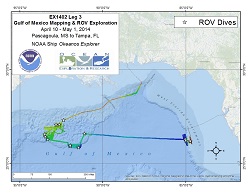
Okeanos Explorer cruise EX1402 leg 3 - the final voyage in the series of three ocean exploration cruises as part of the 2014 Gulf of Mexico Expedition - conducted 16 highly successful telepresence-enabled remotely operated vehicle (ROV) dives in two different areas of the Gulf: The northwestern part of the basin, characterized by a very thick (~12-14 kilometer) accumulation of sediments mobilized from below by evaporites/salt, and the central part of the Florida Escarpment, the western edge of a thick carbonate platform, and the outer shelf next to it. Dive 1 was conducted on April 12, and Dive 16 was conducted on April 29. One dive was sacrificed to inclement weather in the first area, and another in the second area could not be conducted because of strong currents and winds. All of these dives were identified by management groups or support management interests in the region. During the course of these dives, our initial count is that more than 230 different types of animals were documented. Northwestern Gulf of Mexico Dives ROV dives were conducted at a diversity of sites. In the northwestern Gulf of Mexico, dives were conducted at two cold seep sites, two deep-sea coral habitat areas of interest for deep-sea coral modeling, three historic shipwrecks (investigated during two dives), three sites in Keathley Canyon, two sites in Bryant Canyon, and two asphalt volcanoes. Highlights of these dives include discovery of asphalt volcanism (nicknamed "tar lilies") in an area of the Gulf where it was not previously known to occur; discovery of a chronometer (a rare and significant finding for an early 19th century vessel) at Monterrey wrecksite A; and possible extension of the depth range of a few deep-sea coral types in the Gulf of Mexico. Several rare observations also occurred, including Paleodictyon "burrows" in Keathley canyon; a rare orange sea star, Dytaster sp., in Bryant Canyon; and a dumbo octopus displaying a body posture that has never before been observed in cirrate octopods. West Florida Escarpment Dives Four ROV dives were also conducted at priority sites on the central part of the West Florida Escarpment, including two dives investigating seafloor habitats in deep water along the escarpment and two dives documenting deep-sea coral habitat in high-priority areas for fisheries management on the shelf. Highlights from these dives included incredible deep-sea coral diversity (at least 23 species) during one of the deep escarpment dives; discovery of two potential new species of crinoids; and close-up imagery documenting a sea urchin eating an octocoral - an observation rarely, if ever, captured on camera. Mission Participation and Reach More than 70 scientists and students participated in these dives from shore, providing their input and expertise to help characterize these areas and guide the exploration. Online coverage of the expedition including live video feeds, were streamed to shore throughout, allowing hundreds of thousands of the public to join our dives and virtually explore the ocean with us! The expedition was highlighted and shared on more than 150 different media venues in the U.S. and Europe, and the live video feeds received more than 700,000 visits during leg 3. Through social media venues and our website's "Ask an Explorer" link, a tremendous number of comments have been shared by the public, expressing excitement about deep ocean observations and thanking the expedition team for allowing them to "dive" with us.
Expedition Data and Resources
| Ship Navigation Data (ASCII) | Download | Use zip utility to open file |
| Ship SCS/Sensor Data (ASCII) | Download | Use zip utility to open file |
| Ship SCS/Sensor Data (NetCDF) | Open | NetCDF file format: Special software needed to read |
| Shipboard CTDs | Download | Use zip utility to open file |
| Mapping Products | Download | Use zip utility to open file |
| GIS Products | Download | Use zip utility to open file |
Submersible Data and Resources
| Dive Track KMLs | Download | Use zip utility to open file |
| Event Logs | Open | Click to open link |
| Cruise Video Collection Self-Service Portal | Open | Click to open link |
| Submersible Navigation/Sensor Data (ASCII) | Download | Use zip utility to open file |
Educational Resources
| Expedition Education Module | Open | Click to open Education Module |
| Lesson Plans (K-12) | Open | Click to open Lesson Plans |
| Education Materials Collection | Open | Click to open Education Materials |
Links to Archived Data and Resources
| Multibeam Archive Collection | Get Data | Click to Access Archive |
| Water Column Sonar Archive Collection | Get Data | Click to Access Archive |
| Trackline Data (Single-beam and Sub-bottom) | Get Data | Click to Access Archive |
| Physical, Chemical, and Biological Archive Collection | Get Data | Click to Access Archive |
| Collection of Documents | Get Data | Click to Access Archive |
| Expedition Metadata | Open | Click to view Metadata in xml format |
GB648
Area
GB648; Gulf of Mexico
Overview
| Date: | April 12, 2014 |
| Max Depth: | 972.8 Meters |
| Bottom Time: | 6 Hours 18 Minutes 51 Seconds |
Purpose
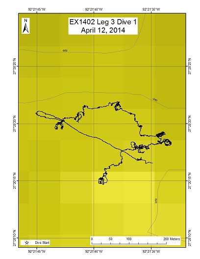
Dive 1 of EX1402 L3 succeeded in achieving the two primary geological objectives set forward by the nominating organization - the Bureau of Ocean Energy Management (BOEM): 1) ascertaining whether high acoustic backscatter (from multibeam bathymetry) and linked high seafloor reflectivity (from 3D seismic/industry data) correlate with hardgrounds, and 2) determining whether seafloor locations of presumed cold seeps as deduced from the origination of ~vertical bubble stream anomalies in the overlying water column (from multibeam bathymetry) are discrete sites of gas escape. Both turned out to be true.
Download & View Files
| Dive Summary Report (PDF - 446 KB) | View/Download | Requires Adobe Acrobat Reader to view the Dive Summary Report |
| Dive Track (KML - 164 KB) | View/Download | Requires Google Earth or equivalent client to view the Dive Track |
| Dive Trailer (MOV - 50 MB) | Download | Link takes you to a public FTP server |
| ROV Ancillary Data (Zip - 1.5 MB) | Download | Link takes you to a public FTP server |
| Camera Platform Sensor Data (Zip - 4.4 MB) | Download | Link takes you to a public FTP server |
| Low-Resolution Video Clips (Zip - 6.96 GB) | Download | Link takes you to a public FTP server |
| Underwater Still Images (Zip - 395 MB) | Download | Link takes you to a public FTP server |
| Dive Video Collection Self-Service Portal | Open | Link takes you to an online video discovery and access tool |
GB907
Area
GB907; Gulf of Mexico
Overview
| Date: | April 13, 2014 |
| Max Depth: | 1266.7 Meters |
| Bottom Time: | 3 Hours 52 Minutes 47 Seconds |
Purpose
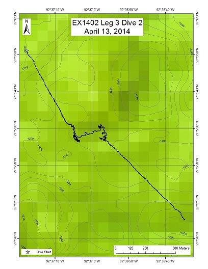
The geological objectives of dive 2, the second dive proposed by the Bureau of Ocean Energy Management (BOEM), involved: Both objectives were confirmed. the search for cold seeps, escape of bubbles/oil from the seafloor as indicated by multibeam bathymetry "bubble stream anomalies", and confirmation that high backscatter returns from the bathymetric high/ridge on which this dive was conducted correlated with (carbonate) hardgrounds on or near the seafloor. Both objectives were confirmed.
Download & View Files
| Dive Summary Report (PDF - 401 KB) | View/Download | Requires Adobe Acrobat Reader to view the Dive Summary Report |
| Dive Track (KML - 117 KB) | View/Download | Requires Google Earth or equivalent client to view the Dive Track |
| Dive Trailer (MOV - 69.8 MB) | Download | Link takes you to a public FTP server |
| ROV Ancillary Data (Zip - 68.3 MB) | Download | Link takes you to a public FTP server |
| Camera Platform Sensor Data (Zip - 3.19 MB) | Download | Link takes you to a public FTP server |
| Low-Resolution Video Clips (Zip - 3.59 GB) | Download | Link takes you to a public FTP server |
| Underwater Still Images (Zip - 301 MB) | Download | Link takes you to a public FTP server |
| Dive Video Collection Self-Service Portal | Open | Link takes you to an online video discovery and access tool |
NW Gulf Mid-Depth
Area
NW Gulf Mid-Depth; Gulf of Mexico
Overview
| Date: | April 14, 2014 |
| Max Depth: | 1155.4 Meters |
| Bottom Time: | 5 Hours 50 Minutes 7 Seconds |
Purpose
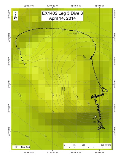
The third dive concentrated on assessing mid-water coral habitats, by examining first the ~30 degree slope, then part of the crest, of a ~100 m high topographic high (part of a sinuous ridge) in depths of ~1150-1050 m. The dive was nominated by Brian Kinlan of NOAA's NCCOS, Center for Coastal Monitoring and Assessment. This dive represents the first of multiple dives designed to quantify models of deep-water coral habitats in the Gulf of Mexico.
Download & View Files
| Dive Summary Report (PDF - 412 KB) | View/Download | Requires Adobe Acrobat Reader to view the Dive Summary Report |
| Dive Track (KML - 181 KB) | View/Download | Requires Google Earth or equivalent client to view the Dive Track |
| Dive Trailer (MOV - 53.5 MB) | Download | Link takes you to a public FTP server |
| ROV Ancillary Data (Zip - 31.4 MB) | Download | Link takes you to a public FTP server |
| Camera Platform Sensor Data (Zip - 4.72 MB) | Download | Link takes you to a public FTP server |
| Low-Resolution Video Clips (Zip - 6.74 GB) | Download | Link takes you to a public FTP server |
| Underwater Still Images (Zip - 470 MB) | Download | Link takes you to a public FTP server |
| Dive Video Collection Self-Service Portal | Open | Link takes you to an online video discovery and access tool |
Keathley Canyon Site KC2
Area
Keathley Canyon Site KC2; Gulf of Mexico
Overview
| Date: | April 16, 2014 |
| Max Depth: | 2003.6 Meters |
| Bottom Time: | 6 Hours 2 Minutes 8 Seconds |
Purpose
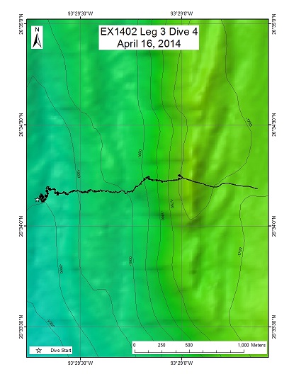
Dive 4 was designed as a transect from the west side of the thalweg (main channel) of Keathley Canyon, in ~2,000 m, across that thalweg and upward, across two west-facing slopes and an intervening bench. The dive ended near the top of that longer second slope, in ~1760 m.
Download & View Files
| Dive Summary Report (PDF - 341 KB) | View/Download | Requires Adobe Acrobat Reader to view the Dive Summary Report |
| Dive Track (KML - 98 KB) | View/Download | Requires Google Earth or equivalent client to view the Dive Track |
| Dive Trailer (MOV - 41.4 MB) | Download | Link takes you to a public FTP server |
| ROV Ancillary Data (Zip - 40.2 MB) | Download | Link takes you to a public FTP server |
| Camera Platform Sensor Data (Zip - 4.73 MB) | Download | Link takes you to a public FTP server |
| Low-Resolution Video Clips (Zip - 3.62 GB) | Download | Link takes you to a public FTP server |
| Underwater Still Images (Zip - 349 MB) | Download | Link takes you to a public FTP server |
| Dive Video Collection Self-Service Portal | Open | Link takes you to an online video discovery and access tool |
n/a
Area
n/a; n/a
Overview
| Date: | April 17, 2014 |
| Max Depth: | n/a |
| Bottom Time: | n/a |
Purpose
n/a
Download & View Files
| Dive Video Collection Self-Service Portal | Open | Link takes you to an online video discovery and access tool |
Keathley Canyon KC3
Area
Keathley Canyon KC3; Gulf of Mexico
Overview
| Date: | April 18, 2014 |
| Max Depth: | 2173.1 Meters |
| Bottom Time: | 5 Hours 28 Minutes 48 Seconds |
Purpose
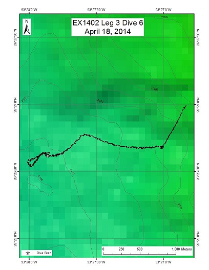
This Keathley Canyon dive site was ~20 km south of dive 4 in the same drainage system. This dive was nominated by Brian Kinlan/Bill Keine. The distribution and abundance of black and bamboo corals was the stated biological priority.
Download & View Files
| Dive Summary Report (PDF - 303 KB) | View/Download | Requires Adobe Acrobat Reader to view the Dive Summary Report |
| Dive Track (KML - 104 KB) | View/Download | Requires Google Earth or equivalent client to view the Dive Track |
| Dive Trailer (MOV - 37.1 MB) | Download | Link takes you to a public FTP server |
| ROV Ancillary Data (Zip - 29.2 MB) | Download | Link takes you to a public FTP server |
| Camera Platform Sensor Data (Zip - 4.76 MB) | Download | Link takes you to a public FTP server |
| Low-Resolution Video Clips (Zip - 3.67 GB) | Download | Link takes you to a public FTP server |
| Underwater Still Images (Zip - 317 MB) | Download | Link takes you to a public FTP server |
| Dive Video Collection Self-Service Portal | Open | Link takes you to an online video discovery and access tool |
n/a
Area
n/a; n/a
Overview
| Date: | April 19, 2014 |
| Max Depth: | n/a |
| Bottom Time: | n/a |
Purpose
n/a
Download & View Files
| Dive Video Collection Self-Service Portal | Open | Link takes you to an online video discovery and access tool |
Keathley Canyon UTIG
Area
Keathley Canyon UTIG; Gulf of Mexico
Overview
| Date: | April 20, 2014 |
| Max Depth: | 2652.4 Meters |
| Bottom Time: | 5 Hours 20 Minutes 56 Seconds |
Purpose
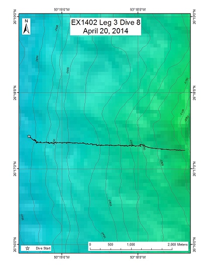
This dive was nominated by the University of Texas, Institute for Geophysics. The focus was the westward-facing slope near the deep-water entrance to Keathley Canyon. Objectives included looking for evidence for brine escape at the seafloor, based upon subsurface seismic evidence for rising salt beneath this slope. The vehicles landed on a slight westward-facing slope at a water depth of 2,655 m, on rippled soft sediment. Until the last 15-20 min of the dive, the bottom was characterized by this type of sedimented seafloor; ripples, consistently suggesting intermittent downslope/down-canyon currents, were often present. The vehicles transited ~2.4 km over the course of the ~5.3 hr. dive, up a ~11 degree slope, across a flat bench at ~2,500 m of water, then up another ~11 degree slope until the end of the dive, at ~2,266 m of water.
Download & View Files
| Dive Summary Report (PDF - 797 KB) | View/Download | Requires Adobe Acrobat Reader to view the Dive Summary Report |
| Dive Track (KML - 111 KB) | View/Download | Requires Google Earth or equivalent client to view the Dive Track |
| Dive Trailer (MOV - 24.8 MB) | Download | Link takes you to a public FTP server |
| ROV Ancillary Data (Zip - 39.4 MB) | Download | Link takes you to a public FTP server |
| Camera Platform Sensor Data (Zip - 4.73 MB) | Download | Link takes you to a public FTP server |
| Low-Resolution Video Clips (Zip - 4.54 GB) | Download | Link takes you to a public FTP server |
| Underwater Still Images (Zip - 455 MB) | Download | Link takes you to a public FTP server |
| Dive Video Collection Self-Service Portal | Open | Link takes you to an online video discovery and access tool |
Bryant Canyon Shallow
Area
Bryant Canyon Shallow; Gulf of Mexico
Overview
| Date: | April 21, 2014 |
| Max Depth: | 2591.4 Meters |
| Bottom Time: | 5 Hours 16 Minutes 36 Seconds |
Purpose
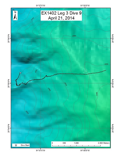
Dive 9 was the first of two dives along the flanks of Bryant Canyon, the easternmost of the three large drainage systems characterizing the north-central Gulf of Mexico. This dive, to examine a ridge along the "shallow" eastern flank of the Canyon, was slated for water depths of ~2,600-2,400 m. The dive was nominated by Tim Shank (WHOI) and Brian Kinlan (NOAA). The primary objective was to characterize deep-water coral habitats, and associated geologic environments.
Download & View Files
| Dive Summary Report (PDF - 307 KB) | View/Download | Requires Adobe Acrobat Reader to view the Dive Summary Report |
| Dive Track (KML - 109 KB) | View/Download | Requires Google Earth or equivalent client to view the Dive Track |
| Dive Trailer (MOV - 26.4 MB) | Download | Link takes you to a public FTP server |
| ROV Ancillary Data (Zip - 47.4 MB) | Download | Link takes you to a public FTP server |
| Camera Platform Sensor Data (Zip - 4.66 MB) | Download | Link takes you to a public FTP server |
| Low-Resolution Video Clips (Zip - 7.7 GB) | Download | Link takes you to a public FTP server |
| Underwater Still Images (Zip - 335 MB) | Download | Link takes you to a public FTP server |
| Dive Video Collection Self-Service Portal | Open | Link takes you to an online video discovery and access tool |
Bryant Canyon Deep
Area
Bryant Canyon Deep; Gulf of Mexico
Overview
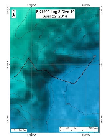
| Date: | April 22, 2014 |
| Max Depth: | 2813 Meters |
| Bottom Time: | 4 Hours 55 Minutes 33 Seconds |
Purpose
This dive consisted of two parts: mid-water examinations at discrete depths for pelagic flora and fauna on descent, and a "deep-water" transect up the western wall of Bryant Canyon. The pelagic transect was nominated by Mike Vecchione of the Smithsonian Institution, and the seafloor dive was nominated by Tim Shank (WHOI) and Brian Kinlan (NOAA). The latter was designed to investigate potential deep-water coral habitats associated with seismic anomalies from BOEM and high backscatter areas registered by multibeam bathymetric data.
Download & View Files
| Dive Summary Report (PDF - 396 KB) | View/Download | Requires Adobe Acrobat Reader to view the Dive Summary Report |
| Dive Track (KML - 135 KB) | View/Download | Requires Google Earth or equivalent client to view the Dive Track |
| Dive Trailer (MOV - 24.9 MB) | Download | Link takes you to a public FTP server |
| ROV Ancillary Data (Zip - 47.3 MB) | Download | Link takes you to a public FTP server |
| Camera Platform Sensor Data (Zip - 5.62 MB) | Download | Link takes you to a public FTP server |
| Low-Resolution Video Clips (Zip - 6.57 GB) | Download | Link takes you to a public FTP server |
| Underwater Still Images (Zip - 468 MB) | Download | Link takes you to a public FTP server |
| Dive Video Collection Self-Service Portal | Open | Link takes you to an online video discovery and access tool |
NW Gulf Deep
Area
NW Gulf Deep; Gulf of Mexico
Overview
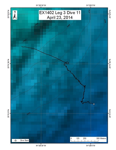
| Date: | April 23, 2014 |
| Max Depth: | 2879.1 Meters |
| Bottom Time: | 4 Hours 46 Minutes 2 Seconds |
Purpose
The focus of this dive was part of the wall of the Sigsbee Escarpment, from water depths of ~2,900-2,700 m. This dive was nominated by Brian Kinlan (NOAA) as true exploration. The primary goal was to characterize deep-water coral habitat, but the overall objective was to observe linked geologic and biological environments in a heretofore unvisited part of the Gulf of Mexico basin.
Download & View Files
| Dive Summary Report (PDF - 365 KB) | View/Download | Requires Adobe Acrobat Reader to view the Dive Summary Report |
| Dive Track (KML - 106 KB) | View/Download | Requires Google Earth or equivalent client to view the Dive Track |
| Dive Trailer (MOV - 30.1 MB) | Download | Link takes you to a public FTP server |
| ROV Ancillary Data (Zip - 41.6 MB) | Download | Link takes you to a public FTP server |
| Camera Platform Sensor Data (Zip - 4.54 MB) | Download | Link takes you to a public FTP server |
| Low-Resolution Video Clips (Zip - 3.69 GB) | Download | Link takes you to a public FTP server |
| Underwater Still Images (Zip - 452 MB) | Download | Link takes you to a public FTP server |
| Dive Video Collection Self-Service Portal | Open | Link takes you to an online video discovery and access tool |
WR0325
Area
WR0325; Gulf of Mexico
Overview
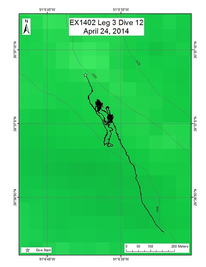
| Date: | April 24, 2014 |
| Max Depth: | 1930.1 Meters |
| Bottom Time: | 5 Hours 46 Minutes 35 Seconds |
Purpose
The primary objective of the dive was to investigate a ~60 m-long sidescan acoustic target, acquired using an industry AUV, composed of two parts with ~5 m seafloor relief, which suggested a shipwreck. This dive was nominated by personnel from the Bureau of Ocean Energy Management (BOEM) and archaeologists from NOAA.
Download & View Files
| Dive Summary Report (PDF - 233 KB) | View/Download | Requires Adobe Acrobat Reader to view the Dive Summary Report |
| Dive Track (KML - 139 KB) | View/Download | Requires Google Earth or equivalent client to view the Dive Track |
| Dive Trailer (MOV - 56.1 MB) | Download | Link takes you to a public FTP server |
| ROV Ancillary Data (Zip - 55.7 MB) | Download | Link takes you to a public FTP server |
| Camera Platform Sensor Data (Zip - 4.42 MB) | Download | Link takes you to a public FTP server |
| Low-Resolution Video Clips (Zip - 6.48 GB) | Download | Link takes you to a public FTP server |
| Underwater Still Images (Zip - 602 MB) | Download | Link takes you to a public FTP server |
| Dive Video Collection Self-Service Portal | Open | Link takes you to an online video discovery and access tool |
Large Mound Deep
Area
Large Mound Deep; Gulf of Mexico
Overview
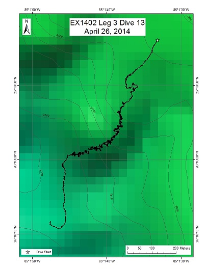
| Date: | April 26, 2014 |
| Max Depth: | 2208.9 Meters |
| Bottom Time: | 5 Hours 13 Minutes 17 Seconds |
Purpose
The primary objective of this dive, up the wall of a prominent salient of the central part of the West Florida Escarpment, was to assess coral habitats, along with any other biology observed (see summary below). The dive was nominated primarily by Brian Kinlan and Peter Etnoyer (NOAA).
Download & View Files
| Dive Summary Report (PDF - 277 KB) | View/Download | Requires Adobe Acrobat Reader to view the Dive Summary Report |
| Dive Track (KML - 115 KB) | View/Download | Requires Google Earth or equivalent client to view the Dive Track |
| Dive Trailer (MOV - 33.3 MB) | Download | Link takes you to a public FTP server |
| ROV Ancillary Data (Zip - 41.8 MB) | Download | Link takes you to a public FTP server |
| Camera Platform Sensor Data (Zip - 4.46 MB) | Download | Link takes you to a public FTP server |
| Low-Resolution Video Clips (Zip - 5.72 GB) | Download | Link takes you to a public FTP server |
| Underwater Still Images (Zip - 663 MB) | Download | Link takes you to a public FTP server |
| Dive Video Collection Self-Service Portal | Open | Link takes you to an online video discovery and access tool |
Many Mounds Deep
Area
Many Mounds Deep; Gulf of Mexico
Overview
| Date: | April 27, 2014 |
| Max Depth: | 2096.2 Meters |
| Bottom Time: | 6 Hours 55 Minutes 45 Seconds |
Purpose
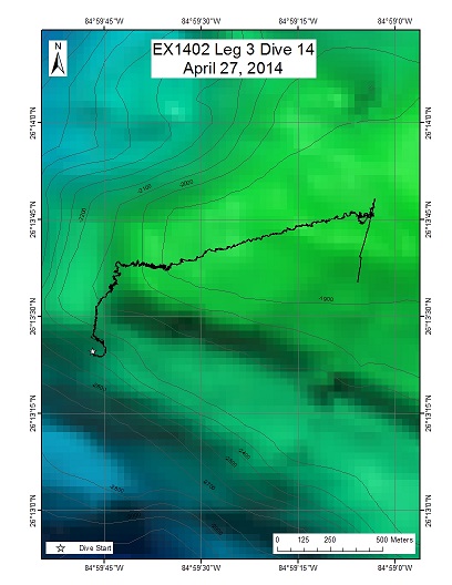
The objective of this second deep dive, from ~2100-1800 m, on the central part of the West Florida Escarpment in an overlapping but shallower depth range than Dive 13, was to complement that dive in quest to characterize deep-water coral habitats. The dive was nominated by Brian Kinlan and Peter Etnoyer (NOAA).
Download & View Files
| Dive Summary Report (PDF - 376 KB) | View/Download | Requires Adobe Acrobat Reader to view the Dive Summary Report |
| Dive Track (KML - 155 KB) | View/Download | Requires Google Earth or equivalent client to view the Dive Track |
| Dive Trailer (MOV - 40.6 MB) | Download | Link takes you to a public FTP server |
| ROV Ancillary Data (Zip - 29.9 MB) | Download | Link takes you to a public FTP server |
| Camera Platform Sensor Data (Zip - 5.37 MB) | Download | Link takes you to a public FTP server |
| Low-Resolution Video Clips (Zip - 4.97 GB) | Download | Link takes you to a public FTP server |
| Underwater Still Images (Zip - 768 MB) | Download | Link takes you to a public FTP server |
| Dive Video Collection Self-Service Portal | Open | Link takes you to an online video discovery and access tool |
Many Mounds South Shallow
Area
Many Mounds South Shallow; Gulf of Mexico
Overview
| Date: | April 28, 2014 |
| Max Depth: | 578.2 Meters |
| Bottom Time: | 6 Hours 13 Minutes 43 Seconds |
Purpose
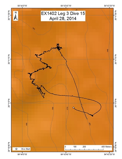
The primary objectives of this shallow (~550 m throughout) dive were to characterize: 1) Lophelia and black coral associations on top of a number of mounds/bioherms known to occur in this vicinity and 2) to focus on golden crab occurrences in the vicinity of these corals. The dive was nominated as one of a series of dives in these water depths by Brian Kinlan and Peter Etnoyer (NOAA) and a team from CIOERT and Harbor Branch led by John Reed (and including Stephanie Farrington).
Download & View Files
| Dive Summary Report (PDF - 345 KB) | View/Download | Requires Adobe Acrobat Reader to view the Dive Summary Report |
| Dive Track (KML - 241 KB) | View/Download | Requires Google Earth or equivalent client to view the Dive Track |
| Dive Trailer (MOV - 38 MB) | Download | Link takes you to a public FTP server |
| ROV Ancillary Data (Zip - 28 MB) | Download | Link takes you to a public FTP server |
| Camera Platform Sensor Data (Zip - 4.21 MB) | Download | Link takes you to a public FTP server |
| Low-Resolution Video Clips (Zip - 7.36 GB) | Download | Link takes you to a public FTP server |
| Underwater Still Images (Zip - 761 MB) | Download | Link takes you to a public FTP server |
| Dive Video Collection Self-Service Portal | Open | Link takes you to an online video discovery and access tool |
Many Mounds South Shallow
Area
Many Mounds South Shallow; Gulf of Mexico
Overview
| Date: | April 29, 2014 |
| Max Depth: | 536.7 Meters |
| Bottom Time: | 5 Hours 43 Minutes 35 Seconds |
Purpose
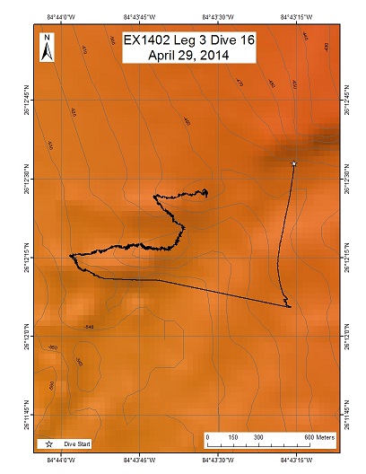
Dive 16 took place north of Dive 15, in a similar water depth range (~550-470 m). The objectives were the same as Dive 15, to characterize: 1) Lophelia and black coral associations on top of a number of mounds/bioherms known to occur in this vicinity and 2) to focus on golden crab occurrences in the vicinity of these corals. The dive was nominated as one of a series of dives in these water depths by Brian Kinlan and Peter Etnoyer (NOAA) and a team from CIOERT and Harbor Branch led by John Reed (and including Stephanie Farrington).
Download & View Files
| Dive Summary Report (PDF - 336 KB) | View/Download | Requires Adobe Acrobat Reader to view the Dive Summary Report |
| Dive Track (KML - 199 KB) | View/Download | Requires Google Earth or equivalent client to view the Dive Track |
| Dive Trailer (MOV - 41 MB) | Download | Link takes you to a public FTP server |
| ROV Ancillary Data (Zip - 27.9 MB) | Download | Link takes you to a public FTP server |
| Camera Platform Sensor Data (Zip - 4.24 MB) | Download | Link takes you to a public FTP server |
| Low-Resolution Video Clips (Zip - 6.39 GB) | Download | Link takes you to a public FTP server |
| Underwater Still Images (Zip - 605 MB) | Download | Link takes you to a public FTP server |
| Dive Video Collection Self-Service Portal | Open | Link takes you to an online video discovery and access tool |

