
Okeanos Explorer (EX1703): CAPSTONE Howland/Baker PRIMNM and PIPA (ROV/Mapping)
Vessel: NOAA Ship Okeanos Explorer; Expedition Dates: March 7 - 29, 2017
Project Principals: Brian Kennedy, NOAA/OAR/OER (Expedition Coordinator); Derek Sowers, NOAA/OAR/OER (Mapping Lead)
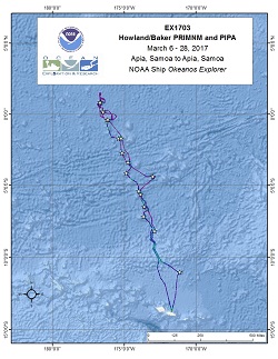
Operations for this cruise will be conducted 24 hours/day and consist of daily remotely operated vehicle (ROV), overnight mapping, CTD casts and full shore-based participation via telepresence. Operations will be conducted within several marine protected areas.
Expedition Data and Resources
| Ship Navigation Data (ASCII) | Download | Use zip utility to open file |
| Ship SCS/Sensor Data (ASCII) | Download | Use zip utility to open file |
| Ship SCS/Sensor Data (NetCDF) | Open | NetCDF file format: Special software needed to read |
| Shipboard CTDs | Download | Use zip utility to open file |
| Mapping Products | Download | Use zip utility to open file |
| GIS Products | Download | Use zip utility to open file |
Submersible Data and Resources
| Dive Track KMLs | Download | Use zip utility to open file |
| Event Logs | Open | Click to open link |
| Cruise Video Collection Self-Service Portal | Open | Click to open link |
| Collected Specimens | Download | Click to open link |
| Submersible Navigation/Sensor Data (ASCII) | Download | Use zip utility to open file |
Collected Specimen Repositories
| Smithsonian Institution's National Museum of Natural History Research and Collections (Biological Samples) | Open | Click to visit repository website |
| Ocean Genome Legacy Center (OGL) at Northeastern University | Open | Click to visit repository website |
| Bernice Pauahi Bishop Museum's Marine Invertebrate Collection | Open | Click to visit repository website |
| Oregon State University's Marine Geology Repository | Open | Click to visit repository website |
Educational Resources
| Expedition Education Module | Open | Click to open Education Module |
| Lesson Plans (K-12) | Open | Click to open Lesson Plans |
| Education Materials Collection | Open | Click to open Education Materials |
Links to Archived Data and Resources
| Multibeam Archive Collection | Get Data | Click to Access Archive |
| Water Column Sonar Archive Collection | Get Data | Click to Access Archive |
| Trackline Data (Single-beam and Sub-bottom) | Get Data | Click to Access Archive |
| Physical, Chemical, and Biological Archive Collection | Get Data | Click to Access Archive |
| Collection of Documents | Get Data | Click to Access Archive |
| Expedition Metadata | Open | Click to view Metadata in xml format |
Swains Atoll
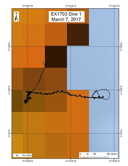
Area
Swains Atoll; National Marine Sanctuary of American Samoa Swains Atoll unit
Overview
| Date: | March 08, 2017 |
| Max Depth: | 1161.3 Meters |
| Bottom Time: | 6 Hours 29 Minutes 47 Seconds |
Purpose
The goal of this dive is to acquire baseline information on deep sea habitats, seafloor geology, and biological communities at the Swains Island region of the National Marine Sanctuary of American Samoa. Geological interests include sampling basalt rocks for dating the age of this feature.
Download & View Files
| Dive Summary Report (PDF - 1.11 MB) | View/Download | Requires Adobe Acrobat Reader to view the Dive Summary Report |
| Dive Track (KML - 192 KB) | View/Download | Requires Google Earth or equivalent client to view the Dive Track |
| ROV Ancillary Data (Zip - 1.54 MB) | Download | Link takes you to a public FTP server |
| ROV CTD/Sensor Data (Zip - 6.47 MB) | Download | Link takes you to a public FTP server |
| Camera Platform Sensor Data (Zip - 6.15 MB) | Download | Link takes you to a public FTP server |
| Low-Resolution Video Clips (Zip - 11.5 GB) | Download | Link takes you to a public FTP server |
| Underwater Still Images (Zip - 113 MB) | Download | Link takes you to a public FTP server |
| Dive Video Collection Self-Service Portal | Open | Link takes you to an online video discovery and access tool |
Pao Pao
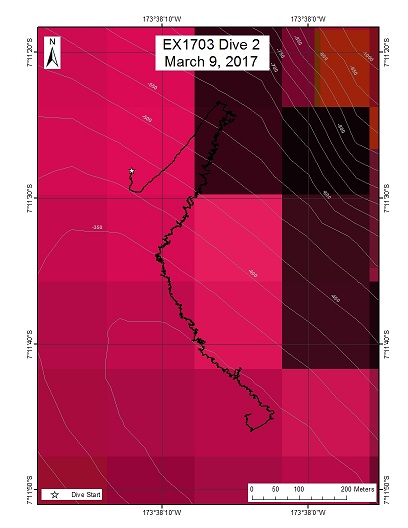
Area
Pao Pao; Tokelau Seamount Chain inside the Tokelau EEZ
Overview
| Date: | March 10, 2017 |
| Max Depth: | 535.6 Meters |
| Bottom Time: | 7 Hours 15 Minutes 46 Seconds |
Purpose
The goal of this dive is to acquire baseline information on deep sea habitats, seafloor geology, and biological communities at Pao Pao Seamount in the Tokelau Seamount Chain. This feature has a summit depth of 300m, with the base at almost 6000 m. The seamount has had some rock dredging, but as far as is known, there has been no dedicated biological survey or sampling.
Download & View Files
| Dive Summary Report (PDF - 1.04 MB) | View/Download | Requires Adobe Acrobat Reader to view the Dive Summary Report |
| Dive Track (KML - 263 KB) | View/Download | Requires Google Earth or equivalent client to view the Dive Track |
| ROV Ancillary Data (Zip - 1.49 MB) | Download | Link takes you to a public FTP server |
| ROV CTD/Sensor Data (Zip - 6.48 MB) | Download | Link takes you to a public FTP server |
| Camera Platform Sensor Data (Zip - 6.86 MB) | Download | Link takes you to a public FTP server |
| Low-Resolution Video Clips (Zip - 11.9 GB) | Download | Link takes you to a public FTP server |
| Underwater Still Images (Zip - 161 MB) | Download | Link takes you to a public FTP server |
| Dive Video Collection Self-Service Portal | Open | Link takes you to an online video discovery and access tool |
Carondelet Reef
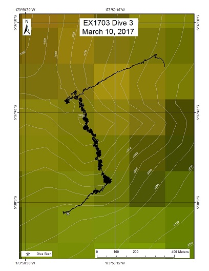
Area
Carondelet Reef; Phoenix Islands Protected Area
Overview
| Date: | March 11, 2017 |
| Max Depth: | 1842.3 Meters |
| Bottom Time: | 6 Hours 1 Minutes 12 Seconds |
Purpose
The goal of this dive is to acquire baseline information on deep sea habitats, seafloor geology, and biological communities in the Carondelet Reef area in the Phoenix Islands Protected Area (PIPA). This will be the first feature in the EX1703 expedition that will lie within the boundaries of PIPA. Deep-sea environments in PIPA are virtually unexplored leading to poor knowledge of biological resources protected by the MPA. This feature has a summit depth of <5m, capped by a submerged reef complex. The base lies at a depth of 5300m.
Download & View Files
| Dive Summary Report (PDF - 1.2 MB) | View/Download | Requires Adobe Acrobat Reader to view the Dive Summary Report |
| Dive Track (KML - 121 KB) | View/Download | Requires Google Earth or equivalent client to view the Dive Track |
| ROV Ancillary Data (Zip - 1.6 MB) | Download | Link takes you to a public FTP server |
| ROV CTD/Sensor Data (Zip - 6.46 MB) | Download | Link takes you to a public FTP server |
| Camera Platform Sensor Data (Zip - 6.23 MB) | Download | Link takes you to a public FTP server |
| Low-Resolution Video Clips (Zip - 11.8 GB) | Download | Link takes you to a public FTP server |
| Underwater Still Images (Zip - 160 MB) | Download | Link takes you to a public FTP server |
| Dive Video Collection Self-Service Portal | Open | Link takes you to an online video discovery and access tool |
Unnamed seamount 1 PIPA (Athena)
Area
Unnamed seamount 1 PIPA (Athena); Phoenix Islands Protected Area
Overview
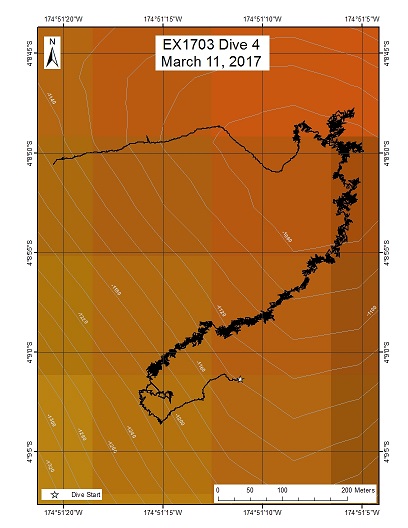
| Date: | March 12, 2017 |
| Max Depth: | 1228.2 Meters |
| Bottom Time: | 6 Hours 43 Minutes 54 Seconds |
Purpose
The goal of this dive is to acquire baseline information on deep sea habitats, seafloor geology, and biological communities on seamounts in the Phoenix Islands Protected Area (PIPA). This will be the second feature in the EX1703 expedition that will lie within the boundaries of PIPA. Deep-sea environments in PIPA are virtually unexplored leading to poor knowledge of biological resources protected by the MPA. This feature has a summit depth of ~1050m with three prominent ridges to the east, west, and south. The summit cap is approx. 250m in diameter.
Download & View Files
| Dive Summary Report (PDF - 1.01 MB) | View/Download | Requires Adobe Acrobat Reader to view the Dive Summary Report |
| Dive Track (KML - 184 KB) | View/Download | Requires Google Earth or equivalent client to view the Dive Track |
| ROV Ancillary Data (Zip - 1.46 MB) | Download | Link takes you to a public FTP server |
| ROV CTD/Sensor Data (Zip - 6.91 MB) | Download | Link takes you to a public FTP server |
| Camera Platform Sensor Data (Zip - 6.35 MB) | Download | Link takes you to a public FTP server |
| Low-Resolution Video Clips (Zip - 12.3 GB) | Download | Link takes you to a public FTP server |
| Underwater Still Images (Zip - 180 MB) | Download | Link takes you to a public FTP server |
| Dive Video Collection Self-Service Portal | Open | Link takes you to an online video discovery and access tool |
Polo Seamount
Area
Polo Seamount; Phoenix Islands Protected Area
Overview
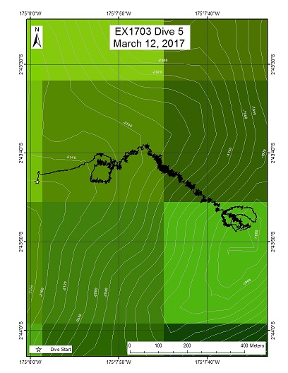
| Date: | March 13, 2017 |
| Max Depth: | 2140.7 Meters |
| Bottom Time: | 5 Hours 44 Minutes 18 Seconds |
Purpose
The goal of this dive is to acquire baseline information on deep sea habitats, seafloor geology, and biological communities on Polo Seamount in the Phoenix Islands Protected Area (PIPA). Deep-sea environments in PIPA are virtually unexplored leading to poor knowledge of biological resources protected by the MPA.
Download & View Files
| Dive Summary Report (PDF - 936 KB) | View/Download | Requires Adobe Acrobat Reader to view the Dive Summary Report |
| Dive Track (KML - 117 KB) | View/Download | Requires Google Earth or equivalent client to view the Dive Track |
| ROV Ancillary Data (Zip - 1.33 MB) | Download | Link takes you to a public FTP server |
| ROV CTD/Sensor Data (Zip - 6.71 MB) | Download | Link takes you to a public FTP server |
| Camera Platform Sensor Data (Zip - 6.44 MB) | Download | Link takes you to a public FTP server |
| Low-Resolution Video Clips (Zip - 11.8 GB) | Download | Link takes you to a public FTP server |
| Underwater Still Images (Zip - 140 MB) | Download | Link takes you to a public FTP server |
| Dive Video Collection Self-Service Portal | Open | Link takes you to an online video discovery and access tool |
Unnamed Seamount West of Winslow Reef
Area
Unnamed Seamount West of Winslow Reef; US EEZ around Howland and Baker Islands
Overview
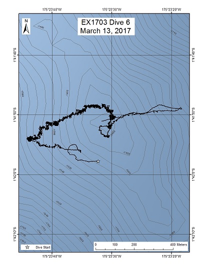
| Date: | March 14, 2017 |
| Max Depth: | 1560.9 Meters |
| Bottom Time: | 6 Hours 22 Minutes 52 Seconds |
Purpose
The goal of this dive is to acquire baseline information on deep sea habitats, seafloor geology, and biological communities on an unnamed seamount in the Winslow Reef complex. Winslow Reef proper lies within the Phoenix Islands Protected Area (PIPA). This feature appears to be part of the complex but lies across the US-Kiribati EEZ boundaries. Deep-sea environments inthe US EEZ around Howland & Baker Unit of the PRIMNM are virtually unexplored leading to poor knowledge of biological resources protected by these reserves.
Download & View Files
| Dive Summary Report (PDF - 1.14 MB) | View/Download | Requires Adobe Acrobat Reader to view the Dive Summary Report |
| Dive Track (KML - 156 KB) | View/Download | Requires Google Earth or equivalent client to view the Dive Track |
| ROV Ancillary Data (Zip - 1.57 MB) | Download | Link takes you to a public FTP server |
| ROV CTD/Sensor Data (Zip - 6.87 MB) | Download | Link takes you to a public FTP server |
| Camera Platform Sensor Data (Zip - 6.57 MB) | Download | Link takes you to a public FTP server |
| Low-Resolution Video Clips (Zip - 12.6 GB) | Download | Link takes you to a public FTP server |
| Underwater Still Images (Zip - 157 MB) | Download | Link takes you to a public FTP server |
| Dive Video Collection Self-Service Portal | Open | Link takes you to an online video discovery and access tool |
Titov Seamount 1
Area
Titov Seamount 1; Pacific Remote Islands Marine National Monument
Overview
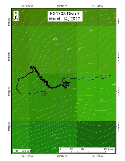
| Date: | March 15, 2017 |
| Max Depth: | 1879.2 Meters |
| Bottom Time: | 5 Hours 28 Minutes 27 Seconds |
Purpose
The goal of this dive is to acquire baseline information on deep sea habitats, seafloor geology, and biological communities on Titov Seamount in the Howland & Baker Unit of the Pacific Remote Islands Marine National Monument. Titov Seamount will be the first feature surveyed in the Howland & Baker Unit of PRIMNM. Titov is a crescent-shaped flat-topped guyot with a prominent ridge protruding from the western flank. Deep-sea environments around Howland & Baker islands are virtually unexplored leading to poor knowledge of biological resources protected by these reserves. In addition, this feature does not have a geologic age yet assigned to it.
Download & View Files
| Dive Summary Report (PDF - 1.13 MB) | View/Download | Requires Adobe Acrobat Reader to view the Dive Summary Report |
| Dive Track (KML - 134 KB) | View/Download | Requires Google Earth or equivalent client to view the Dive Track |
| ROV Ancillary Data (Zip - 1.54 MB) | Download | Link takes you to a public FTP server |
| ROV CTD/Sensor Data (Zip - 6.6 MB) | Download | Link takes you to a public FTP server |
| Camera Platform Sensor Data (Zip - 6.29 MB) | Download | Link takes you to a public FTP server |
| Low-Resolution Video Clips (Zip - 11.6 GB) | Download | Link takes you to a public FTP server |
| Underwater Still Images (Zip - 145 MB) | Download | Link takes you to a public FTP server |
| Dive Video Collection Self-Service Portal | Open | Link takes you to an online video discovery and access tool |
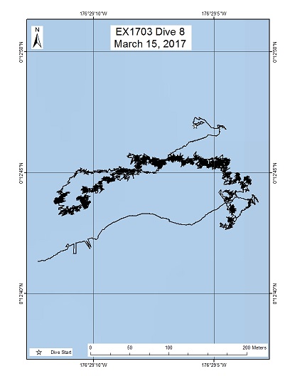
Baker Island Shallow
Area
Baker Island Shallow; Pacific Remote Islands Marine National Monument
Overview
| Date: | March 16, 2017 |
| Max Depth: | 725.5 Meters |
| Bottom Time: | 6 Hours 7 Minutes 23 Seconds |
Purpose
The goal of this dive is to acquire baseline information on deep sea habitats, seafloor geology, and biological communities on Baker Island in the Howland & Baker Unit of the Pacific Remote Islands Marine National Monument. Deep-sea environments around Howland & Baker Islands are virtually unexplored leading to poor knowledge of biological resources protected by these reserves.
Download & View Files
| Dive Summary Report (PDF - 928 KB) | View/Download | Requires Adobe Acrobat Reader to view the Dive Summary Report |
| Dive Track (KML - 211 KB) | View/Download | Requires Google Earth or equivalent client to view the Dive Track |
| ROV Ancillary Data (Zip - 1.32 MB) | Download | Link takes you to a public FTP server |
| ROV CTD/Sensor Data (Zip - 6.26 MB) | Download | Link takes you to a public FTP server |
| Camera Platform Sensor Data (Zip - 5.77 MB) | Download | Link takes you to a public FTP server |
| Low-Resolution Video Clips (Zip - 10.8 GB) | Download | Link takes you to a public FTP server |
| Underwater Still Images (Zip - 173 MB) | Download | Link takes you to a public FTP server |
| Dive Video Collection Self-Service Portal | Open | Link takes you to an online video discovery and access tool |
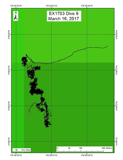
Howland Island Deep 1
Area
Howland Island Deep 1; Pacific Remote Islands Marine National Monument
Overview
| Date: | March 17, 2017 |
| Max Depth: | 2420.1 Meters |
| Bottom Time: | 5 Hours 7 Minutes 56 Seconds |
Purpose
The goal of this dive is to acquire baseline information on deep sea habitats, seafloor geology, and biological communities on Howland Island in the Howland & Baker Unit of the Pacific Remote Islands Marine National Monument. Deep-sea environments around Howland & Baker Islands are virtually unexplored leading to poor knowledge of biological resources protected by these reserves. Two dives will be conducted at Howland Island, one deep (this dive) and one shallow (following day). Understanding deep-sea coral biological resources as well as bathyal fish communities is of great importance to inform management in the area. This feature has been dated to 70-74MY old (*see Koppers et al 2007 Geochem. Geophys. Geosyst.)
Download & View Files
| Dive Summary Report (PDF - 971 KB) | View/Download | Requires Adobe Acrobat Reader to view the Dive Summary Report |
| Dive Track (KML - 102 KB) | View/Download | Requires Google Earth or equivalent client to view the Dive Track |
| ROV Ancillary Data (Zip - 1.33 MB) | Download | Link takes you to a public FTP server |
| ROV CTD/Sensor Data (Zip - 6.77 MB) | Download | Link takes you to a public FTP server |
| Camera Platform Sensor Data (Zip - 6.25 MB) | Download | Link takes you to a public FTP server |
| Low-Resolution Video Clips (Zip - 11.3 GB) | Download | Link takes you to a public FTP server |
| Underwater Still Images (Zip - 134 MB) | Download | Link takes you to a public FTP server |
| Dive Video Collection Self-Service Portal | Open | Link takes you to an online video discovery and access tool |
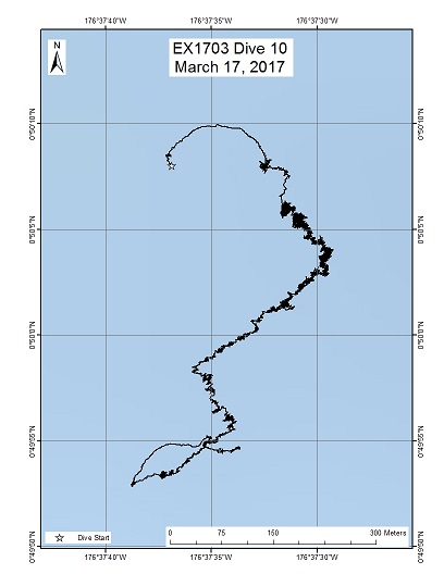
Howland Island Shallow
Area
Howland Island Shallow; Pacific Remote Islands Marine National Monument
Overview
| Date: | March 18, 2017 |
| Max Depth: | 587.7 Meters |
| Bottom Time: | 6 Hours 8 Minutes 38 Seconds |
Purpose
The goal of this dive is to acquire baseline information on deep sea habitats, seafloor geology, and biological communities on Howland Island in the Howland & Baker Unit of the Pacific Remote Islands Marine National Monument. Deep-sea environments around Howland & Baker Islands are virtually unexplored leading to poor knowledge of biological resources protected by these reserves. This dive will target shallower depths (<600m) of Howland Island to examine deep-sea coral, sponge, and fish communities and contrast those observations to a similar dive profile at Baker Is. Understanding deep-sea coral habitat distribution as well as fish communities is of great importance to inform management in the area. This feature has been dated to 70-74MY old (*see Koppers et al 2007 Geochem. Geophys. Geosyst.)
Download & View Files
| Dive Summary Report (PDF - 1.12 MB) | View/Download | Requires Adobe Acrobat Reader to view the Dive Summary Report |
| Dive Track (KML - 215 KB) | View/Download | Requires Google Earth or equivalent client to view the Dive Track |
| ROV Ancillary Data (Zip - 1.53 MB) | Download | Link takes you to a public FTP server |
| ROV CTD/Sensor Data (Zip - 6.11 MB) | Download | Link takes you to a public FTP server |
| Camera Platform Sensor Data (Zip - 5.75 MB) | Download | Link takes you to a public FTP server |
| Low-Resolution Video Clips (Zip - 10.7 GB) | Download | Link takes you to a public FTP server |
| Underwater Still Images (Zip - 180 MB) | Download | Link takes you to a public FTP server |
| Dive Video Collection Self-Service Portal | Open | Link takes you to an online video discovery and access tool |
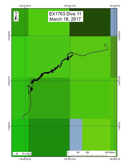
Howland Deep 2
Area
Howland Deep 2; Pacific Remote Islands Marine National Monument
Overview
| Date: | March 19, 2017 |
| Max Depth: | 2226.9 Meters |
| Bottom Time: | 5 Hours 35 Minutes 16 Seconds |
Purpose
The goal of this dive is to acquire baseline information on deep sea habitats, seafloor geology, and biological communities on Howland Island in the Howland & Baker Unit of the Pacific Remote Islands Marine National Monument. Deep-sea environments around Howland & Baker Islands are virtually unexplored leading to poor knowledge of biological resources protected by these reserves. Previous Dive09 (this cruise) explored a steep slope downslope from this large ridge. This dive will carry on where the previous dive left off to survey the remainder of the ridge crest, including taking a closer look at a diversity of octocorals at the dive start location. Understanding deep-sea coral biological resources as well as bathyal fish communities is of great importance to inform management in the area.
Download & View Files
| Dive Summary Report (PDF - 1 MB) | View/Download | Requires Adobe Acrobat Reader to view the Dive Summary Report |
| Dive Track (KML - 118 KB) | View/Download | Requires Google Earth or equivalent client to view the Dive Track |
| ROV Ancillary Data (Zip - 1.42 MB) | Download | Link takes you to a public FTP server |
| ROV CTD/Sensor Data (Zip - 6.61 MB) | Download | Link takes you to a public FTP server |
| Camera Platform Sensor Data (Zip - 6.14 MB) | Download | Link takes you to a public FTP server |
| Low-Resolution Video Clips (Zip - 11.8 GB) | Download | Link takes you to a public FTP server |
| Underwater Still Images (Zip - 150 MB) | Download | Link takes you to a public FTP server |
| Dive Video Collection Self-Service Portal | Open | Link takes you to an online video discovery and access tool |
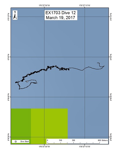
Baker Islands Deep
Area
Baker Islands Deep; Pacific Remote Islands Marine National Monument (PRIMNM)
Overview
| Date: | March 20, 2017 |
| Max Depth: | 1858.7 Meters |
| Bottom Time: | 6 Hours 6 Minutes 8 Seconds |
Purpose
The general goal of this dive is to acquire baseline information on deep sea habitats, seafloor geology, and biological communities on Baker Island in the Howland & Baker Unit of the Pacific Remote Islands Marine National Monument. Deep-sea environments around Howland & Baker Islands are virtually unexplored leading to poor knowledge of biological resources protected by these reserves. The previous Dive08 (this cruise) explored shallow and carbonate karstic terrain as well as upper bathyal fish communities <600m depth. This dive will provide some perspective on biological resources as well as geological foundations of the island. Understanding deep-sea coral distribution as well as bathyal fish communities is of great importance to inform management in the area. Additionally, the age of Baker Island is not known, nor has any record of rock dredging in the area been reported.
Download & View Files
| Dive Summary Report (PDF - 1.01 MB) | View/Download | Requires Adobe Acrobat Reader to view the Dive Summary Report |
| Dive Track (KML - 139 KB) | View/Download | Requires Google Earth or equivalent client to view the Dive Track |
| ROV Ancillary Data (Zip - 1.44 MB) | Download | Link takes you to a public FTP server |
| ROV CTD/Sensor Data (Zip - 6.54 MB) | Download | Link takes you to a public FTP server |
| Camera Platform Sensor Data (Zip - 6.34 MB) | Download | Link takes you to a public FTP server |
| Low-Resolution Video Clips (Zip - 12.1 GB) | Download | Link takes you to a public FTP server |
| Underwater Still Images (Zip - 177 MB) | Download | Link takes you to a public FTP server |
| Dive Video Collection Self-Service Portal | Open | Link takes you to an online video discovery and access tool |
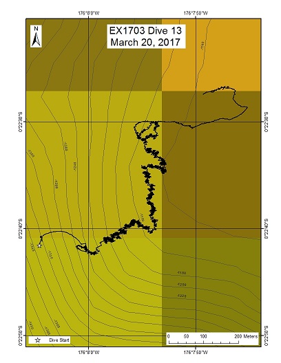
Titov 2
Area
Titov 2; Pacific Remote Islands Marine National Monument
Overview
| Date: | March 21, 2017 |
| Max Depth: | 1226.7 Meters |
| Bottom Time: | 6 Hours 14 Minutes 46 Seconds |
Purpose
The general goal of this dive is to acquire baseline information on deep sea habitats, seafloor geology, and biological communities on Titov Seamount in the Howland & Baker Unit of the Pacific Remote Islands Marine National Monument. Deep-sea environments around the Howland & Baker Islands are virtually unexplored leading to poor knowledge of biological resources protected by these reserves. This expedition has already explored the western ridge of Titov Seamount (Dive07) at a depth of 1890-1740m. This dive will provide some perspective on biological resources (fishes, biogenic habitat) as well as geological resources (crust precipitates) of the seamount. Understanding deep-sea coral distribution as well as bathyal fish communities is of great importance to inform management in the area. The age of Titov Seamount is not known.
Download & View Files
| Dive Summary Report (PDF - 897 KB) | View/Download | Requires Adobe Acrobat Reader to view the Dive Summary Report |
| Dive Track (KML - 170 KB) | View/Download | Requires Google Earth or equivalent client to view the Dive Track |
| ROV Ancillary Data (Zip - 1.29 MB) | Download | Link takes you to a public FTP server |
| ROV CTD/Sensor Data (Zip - 6.52 MB) | Download | Link takes you to a public FTP server |
| Camera Platform Sensor Data (Zip - 6.14 MB) | Download | Link takes you to a public FTP server |
| Low-Resolution Video Clips (Zip - 11.9 GB) | Download | Link takes you to a public FTP server |
| Underwater Still Images (Zip - 160 MB) | Download | Link takes you to a public FTP server |
| Dive Video Collection Self-Service Portal | Open | Link takes you to an online video discovery and access tool |
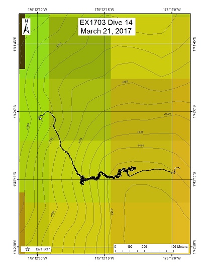
Unnamed Seamount West of Winslow Reef PIPA
Area
Unnamed Seamount West of Winslow Reef PIPA; Phoenix Islands Protected Area
Overview
| Date: | March 22, 2017 |
| Max Depth: | 1535.5 Meters |
| Bottom Time: | 6 Hours 3 Minutes 59 Seconds |
Purpose
The general goal of this dive is to acquire baseline information on deep sea habitats, seafloor geology, and biological communities on features around Winslow Reef in the Phoenix Islands Protected Area (PIPA). Deep-sea environments around Winslow Reef are virtually unexplored leading to poor knowledge of biological resources protected by the reserves. This dive will provide some perspective on biological resources (e.g. fishes, biogenic habitat) as well as geological resources (crust precipitates) of the seamount. Understanding deep-sea coral distribution as well as bathyal fish communities is of great importance to inform management in the Phoenix Islands Protected Area and a nearby seamount in the US EEZ. The age of this seamount is not known.
Download & View Files
| Dive Summary Report (PDF - 871 KB) | View/Download | Requires Adobe Acrobat Reader to view the Dive Summary Report |
| Dive Track (KML - 159 KB) | View/Download | Requires Google Earth or equivalent client to view the Dive Track |
| ROV Ancillary Data (Zip - 1.29 MB) | Download | Link takes you to a public FTP server |
| ROV CTD/Sensor Data (Zip - 6.46 MB) | Download | Link takes you to a public FTP server |
| Camera Platform Sensor Data (Zip - 6.16 MB) | Download | Link takes you to a public FTP server |
| Low-Resolution Video Clips (Zip - 11.7 GB) | Download | Link takes you to a public FTP server |
| Underwater Still Images (Zip - 219 MB) | Download | Link takes you to a public FTP server |
| Dive Video Collection Self-Service Portal | Open | Link takes you to an online video discovery and access tool |
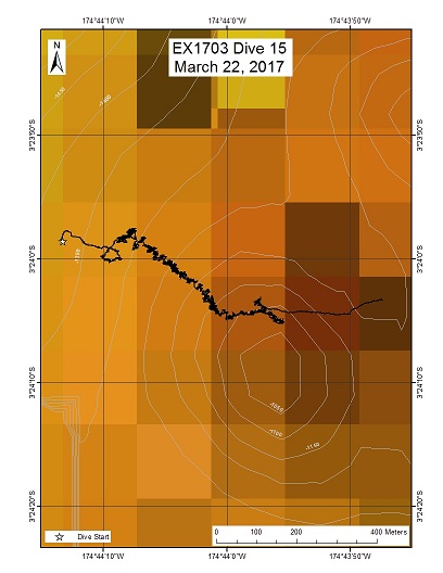
Unnamed Seamount "Teutana Seamount"
Area
Unnamed Seamount "Teutana Seamount"; Phoenix Islands Protected Area
Overview
| Date: | March 23, 2017 |
| Max Depth: | 1325.4 Meters |
| Bottom Time: | 4 Hours 57 Minutes 31 Seconds |
Purpose
The general goal of this dive is to acquire baseline information on deep sea habitats, seafloor geology, and biological communities on features around the tentatively-named "Teutana Seamount" ("a little" in Kiribati), in the Phoenix Islands Protected Area (PIPA). Deep-sea environments on seamounts in PIPA are virtually unexplored leading to poor knowledge of any biological resources protected by the reserve. This dive will provide some perspective on biological resources (e.g. fishes, biogenic habitat) as well as geological resources (crust precipitates) of the seamount. Understanding deep-sea coral and sponge distribution as well as bathyal fish communities is important to inform management in the Phoenix Islands Protected Area. The age of this seamount has not been determined from rock dating.
Download & View Files
| Dive Summary Report (PDF - 1.13 MB) | View/Download | Requires Adobe Acrobat Reader to view the Dive Summary Report |
| Dive Track (KML - 140 KB) | View/Download | Requires Google Earth or equivalent client to view the Dive Track |
| ROV Ancillary Data (Zip - 1.46 MB) | Download | Link takes you to a public FTP server |
| ROV CTD/Sensor Data (Zip - 5.2 MB) | Download | Link takes you to a public FTP server |
| Camera Platform Sensor Data (Zip - 5.06 MB) | Download | Link takes you to a public FTP server |
| Low-Resolution Video Clips (Zip - 9.4 GB) | Download | Link takes you to a public FTP server |
| Underwater Still Images (Zip - 179 MB) | Download | Link takes you to a public FTP server |
| Dive Video Collection Self-Service Portal | Open | Link takes you to an online video discovery and access tool |
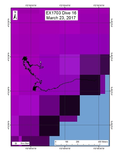
Hadal Trough "Kinono"
Area
Hadal Trough "Kinono"; Phoenix Islands Protected Area
Overview
| Date: | March 24, 2017 |
| Max Depth: | 5862.9 Meters |
| Bottom Time: | 3 Hours 38 Minutes 0 Seconds |
Purpose
The general goal of this dive is to acquire baseline information on deep sea habitats, seafloor geology, and biological communities at hadal depths in the Phoenix Islands Protected Area (PIPA). We will be diving in one of the few non-trench associated hadal zones in the Pacific Ocean. Most hadal environments are virtually unexplored and there is little understanding of what resources might be protected at such depths. This dive will provide some perspective on biological resources (e.g. fishes, biogenic structures) as well as seafloor geology at these depths. The geological processes for formation of the Nova-Canton Trough could also be associated with the formation of this this hadal trough in the Phoenix Islands.
Download & View Files
| Dive Summary Report (PDF - 1.01 MB) | View/Download | Requires Adobe Acrobat Reader to view the Dive Summary Report |
| Dive Track (KML - 38.7 KB) | View/Download | Requires Google Earth or equivalent client to view the Dive Track |
| ROV Ancillary Data (Zip - 1.46 MB) | Download | Link takes you to a public FTP server |
| ROV CTD/Sensor Data (Zip - 8.15 MB) | Download | Link takes you to a public FTP server |
| Camera Platform Sensor Data (Zip - 7.63 MB) | Download | Link takes you to a public FTP server |
| Low-Resolution Video Clips (Zip - 15 GB) | Download | Link takes you to a public FTP server |
| Underwater Still Images (Zip - 111 MB) | Download | Link takes you to a public FTP server |
| Dive Video Collection Self-Service Portal | Open | Link takes you to an online video discovery and access tool |
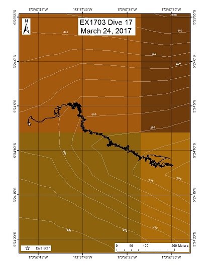
Unnamed Seamount (Maibua in Kiribati meaning "broken in two")
Area
Unnamed Seamount (Maibua in Kiribati meaning "broken in two"); Phoenix Islands Protected Area
Overview
| Date: | March 25, 2017 |
| Max Depth: | 750.9 Meters |
| Bottom Time: | 7 Hours 10 Minutes 40 Seconds |
Purpose
The general goal of this dive is to acquire baseline information on deep sea habitats, seafloor geology, and biological communities on features around an unnamed seamount (Maibua in Kiribati meaning "broken in two") in the Phoenix Islands Protected Area (PIPA). Assessment of early multibeam bathymetry for this feature indicates a potential mass wasting of one side of the seamount. Our dive will track along a moderate to steep ridge from ~700m to ~400m and will be our shallowest dive to date at a PIPA feature. Deep-sea environments in this area are virtually unexplored leading to poor knowledge of biological resources protected by the reserve. This dive will provide some perspective on biological resources (e.g. fishes, biogenic habitat) as well as geological substrate (crust precipitates) of the seamount. Understanding deep-sea coral and sponge distribution as well as bathyal fish assemblages are of great importance to inform management in the PIPA. The age of seamount is not known.
Download & View Files
| Dive Summary Report (PDF - .98 MB) | View/Download | Requires Adobe Acrobat Reader to view the Dive Summary Report |
| Dive Track (KML - 228 KB) | View/Download | Requires Google Earth or equivalent client to view the Dive Track |
| ROV Ancillary Data (Zip - 1.43 MB) | Download | Link takes you to a public FTP server |
| ROV CTD/Sensor Data (Zip - 6.78 MB) | Download | Link takes you to a public FTP server |
| Camera Platform Sensor Data (Zip - 6.47 MB) | Download | Link takes you to a public FTP server |
| Low-Resolution Video Clips (Zip - 11.9 GB) | Download | Link takes you to a public FTP server |
| Underwater Still Images (Zip - 295 MB) | Download | Link takes you to a public FTP server |
| Dive Video Collection Self-Service Portal | Open | Link takes you to an online video discovery and access tool |
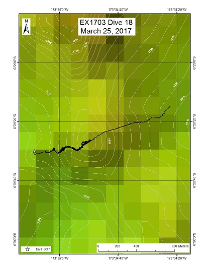
Unnamed Seamount "Te Kaitira"
Area
Unnamed Seamount "Te Kaitira"; Phoenix Islands Protected Area
Overview
| Date: | March 26, 2017 |
| Max Depth: | 2104.9 Meters |
| Bottom Time: | 5 Hours 43 Minutes 50 Seconds |
Purpose
The general goal of this dive is to acquire baseline information on deep sea habitats, seafloor geology, and biological communities on features around an unnamed seamount ("Te Kaitira" in Gilbertese meaning "the last") in the Phoenix Islands Protected Area (PIPA). Our dive will survey a feature south of the seamount proper on a small, deep knoll with a summit depth of 1800m. Deep-sea environments in this area are virtually unexplored leading to poor knowledge of biological resources protected within the boundaries of the protected area. This dive will provide some perspective on biological resources (e.g. fishes, biogenic habitat) as well as geological substrate (crust precipitates) of the seamount. Understanding deep-sea coral and sponge distribution, as well as bathyal fish assemblages, are of great importance to inform management in the PIPA. The age of this seamount is not known but nearby Matai Seamount to the south is aged around 61Ma.
Download & View Files
| Dive Summary Report (PDF - 1.01 MB) | View/Download | Requires Adobe Acrobat Reader to view the Dive Summary Report |
| Dive Track (KML - 122 KB) | View/Download | Requires Google Earth or equivalent client to view the Dive Track |
| ROV Ancillary Data (Zip - 1.42 MB) | Download | Link takes you to a public FTP server |
| ROV CTD/Sensor Data (Zip - 6.6 MB) | Download | Link takes you to a public FTP server |
| Camera Platform Sensor Data (Zip - 6.31 MB) | Download | Link takes you to a public FTP server |
| Low-Resolution Video Clips (Zip - 11.8 GB) | Download | Link takes you to a public FTP server |
| Underwater Still Images (Zip - 262 MB) | Download | Link takes you to a public FTP server |
| Dive Video Collection Self-Service Portal | Open | Link takes you to an online video discovery and access tool |
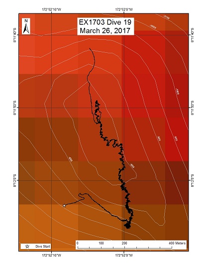
Unnamed seamount "Te Kaitira"
Area
Unnamed seamount "Te Kaitira"; Phoenix Islands Protected Area
Overview
| Date: | March 27, 2017 |
| Max Depth: | 998.7 Meters |
| Bottom Time: | 6 Hours 33 Minutes 2 Seconds |
Purpose
The general goal of this dive is to acquire baseline information on deep sea habitats, seafloor geology, and biological communities on Ufiata Seamount in the Tokelau region. The geologic age of this feature is around 57-58Ma. The structure of this seamount might make it suitable for the deposition of cobalt-rich ferromanganese crust. It falls within an area identified by SPC as a zone of crust potential, based on sampling by a joint Japan-SOPAC deep-sea minerals program in the 1990s.
Download & View Files
| Dive Summary Report (PDF - 1.19 MB) | View/Download | Requires Adobe Acrobat Reader to view the Dive Summary Report |
| Dive Track (KML - 192 KB) | View/Download | Requires Google Earth or equivalent client to view the Dive Track |
| ROV Ancillary Data (Zip - 1.63 MB) | Download | Link takes you to a public FTP server |
| ROV CTD/Sensor Data (Zip - 6.51 MB) | Download | Link takes you to a public FTP server |
| Camera Platform Sensor Data (Zip - 6.03 MB) | Download | Link takes you to a public FTP server |
| Low-Resolution Video Clips (Zip - 11.5 GB) | Download | Link takes you to a public FTP server |
| Underwater Still Images (Zip - 139 MB) | Download | Link takes you to a public FTP server |
| Dive Video Collection Self-Service Portal | Open | Link takes you to an online video discovery and access tool |

