

OAA and its partners have released the latest Regional Climate Impacts and Outlooks, which recap summer conditions and provide insight into what might be expected this autumn.
Summer Temperature Recap
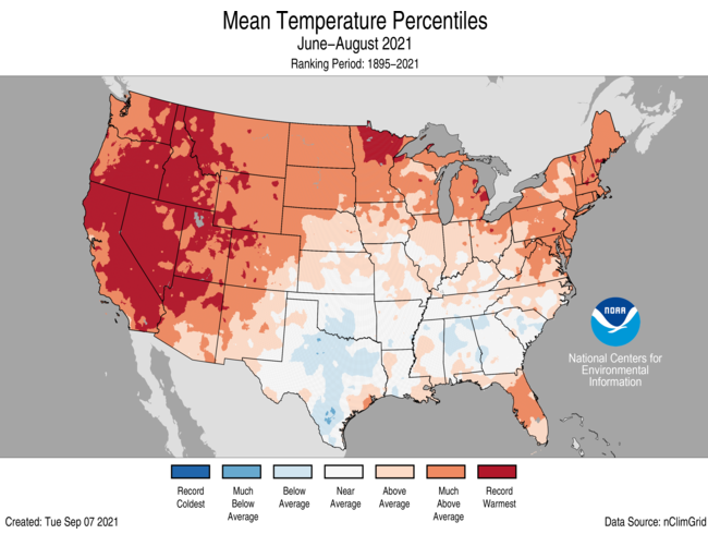
Summer temperatures were above average to record warmest from the West Coast to the Great Lakes and into the Northeast as well as across portions of the Mid-Atlantic and Gulf Coast. Temperatures were below average across portions of the southern Plains and Southeast. The Alaska statewide average temperature for the summer was 51.4°F, 1.0°F above average and ranked in the warmest one-third of the 97-year record. Temperatures were warmer than average across much of the eastern half of the state as well as across the Aleutians and near average for much of the rest of the state. California, Nevada, Utah, Oregon, and Idaho each reported their warmest June-August on record. Sixteen additional states had a top-five warmest summer on record. No state ranked below average for the summer season.

Autumn Temperature Outlook
The October–November–December (OND) 2021 temperature outlook favors above normal temperatures for the southern two-thirds of the contiguous United States (CONUS), the eastern third of the CONUS, and western Alaska, with the largest probabilities (greater than 50 percent) forecast across the Southwest and New England.

Courtesy of NOAA Climate Prediction Office
Summer Precipitation Recap
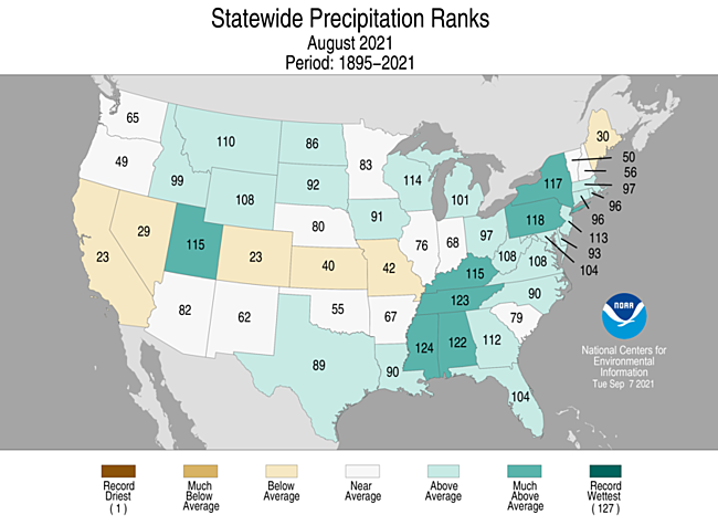
Precipitation was above average across portions of the central and northern Rockies, the northern Plains, Great Lakes, and from the Deep South to southern New England. Mississippi ranked fourth wettest while Tennessee had its fifth-wettest August on record. The Southwest monsoon continued to be active in August, eliminating much of the year-to-date precipitation deficit across the region. Tucson, Arizona, had its wettest August and second-wettest summer on record. Precipitation was below average across portions of the West, southern Rockies, central Plains, Midwest, northern Great Lakes, and northern New England. Precipitation in Alaska was above average across much of the northern half of the state as well as across portions of the Northeast Gulf and Panhandle regions. Kotzebue had its wettest summer on record, reporting 9.21 inches and besting the previous record, set in 1963, by nearly an inch.

Autumn Precipitation Outlook
The Autumn 2021 precipitation outlook depicts enhanced probabilities of below normal precipitation amounts across the Southern Tier and much of the central CONUS. Above-normal precipitation is more likely for the northwestern CONUS, the Eastern Great Lakes, parts of the interior Northeast, and parts of southwestern Alaska.

Impacts and Outlooks for Your Region
Get more details for your region in the September 2021 climate impacts and outlooks summaries:
- Alaska and Northwestern Canada Region
- Mid-Atlantic Region
- Northeast Region
- Great Lakes Region
- Gulf of Maine Region
- Midwest Region
- Missouri River Basin Region
- Pacific Region
- Southeast Region
- Southern Region
- Western Region
Creating These Quarterly Summaries
NOAA’s Regional Climate Services lead the production of these quarterly summaries of climate impacts and outlooks for various regions of the United States as well as parts of Canada along the border. This effort, which began in 2012, now includes as many as 11 unique regional products, all produced collaboratively with partner organizations.
You can access all of the Climate Impacts and Outlooks summaries as well as additional reports and assessments through the U.S. Drought Portal Reports web page at Drought.gov.


