Monthly Report Summary Information
The Monthly Report Summary Information is a synopsis of the collection of national and global summaries released each month.
Global Summary Information - December 2013
See Full Report
2013 global temperature ties as fourth warmest on record since 1880
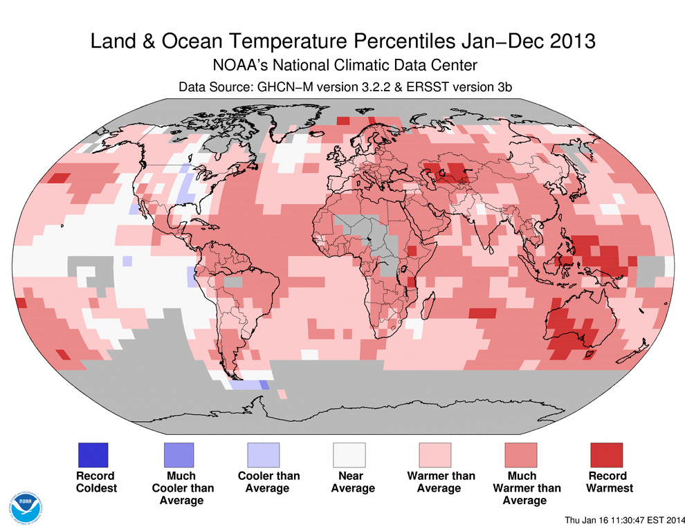
The globally-averaged temperature for 2013 tied as the fourth warmest year since record keeping began in 1880. It also marked the 37th consecutive year with a global temperature above the 20th century average. The last below-average annual temperature was 1976. Including 2013, all 13 years of the 21st century (2001-2013) rank among the 15 warmest in the 134-year period of record. The three warmest years on record are 2010, 2005, and 1998.
Most areas of the world experienced above-average annual temperatures. Over land, parts of central Asia, western Ethiopia, eastern Tanzania, and much of southern and western Australia were record warm, as were sections of the Arctic Ocean, a large swath of the southwestern Pacific Ocean, parts of the central Pacific, and an area of the central Indian Ocean. Only part of the central United States was cooler than average over land. Small regions scattered across the eastern Pacific Ocean and a region of the Southern Ocean south of South America were cooler than average. No region of the globe was record cold during 2013.
2013 Global temperature highlights
- The globally-averaged annual combined land and ocean surface temperature was 0.62°C (1.12°F) above the 20th century average of 13.9°C (57.0°F). Numerically, this temperature departure for 2013 tied with 2003 as the fourth warmest year since records began in 1880. Even when considering a margin of error of ±0.09°C (0.16°F), 2013 is still more likely than not to be among the top five warmest years on record.
- 2013 also marked the 37th consecutive year with a global temperature above the 20th century average. The last colder-than-average year was 1976.
- The global annual temperature has increased at an average rate of 0.06°C (0.11°F) per decade since 1880 and at an average rate of 0.16°C (0.28°F) per decade since 1970.
- The 2013 worldwide land surface temperature was 0.99°C (1.78°F) above the 20th century average, making it the fourth warmest such period on record. The margin of error is ±0.19°C (0.34°F).
- The Arctic Oscillation was a major driver of weather patterns over land during early 2013 across the Northern Hemisphere, bringing cooler-than-average spring temperatures to much of Europe, the southeastern United States, northwestern Russia, and parts of Japan. In contrast, the Arctic region was considerably warmer than average during this period.
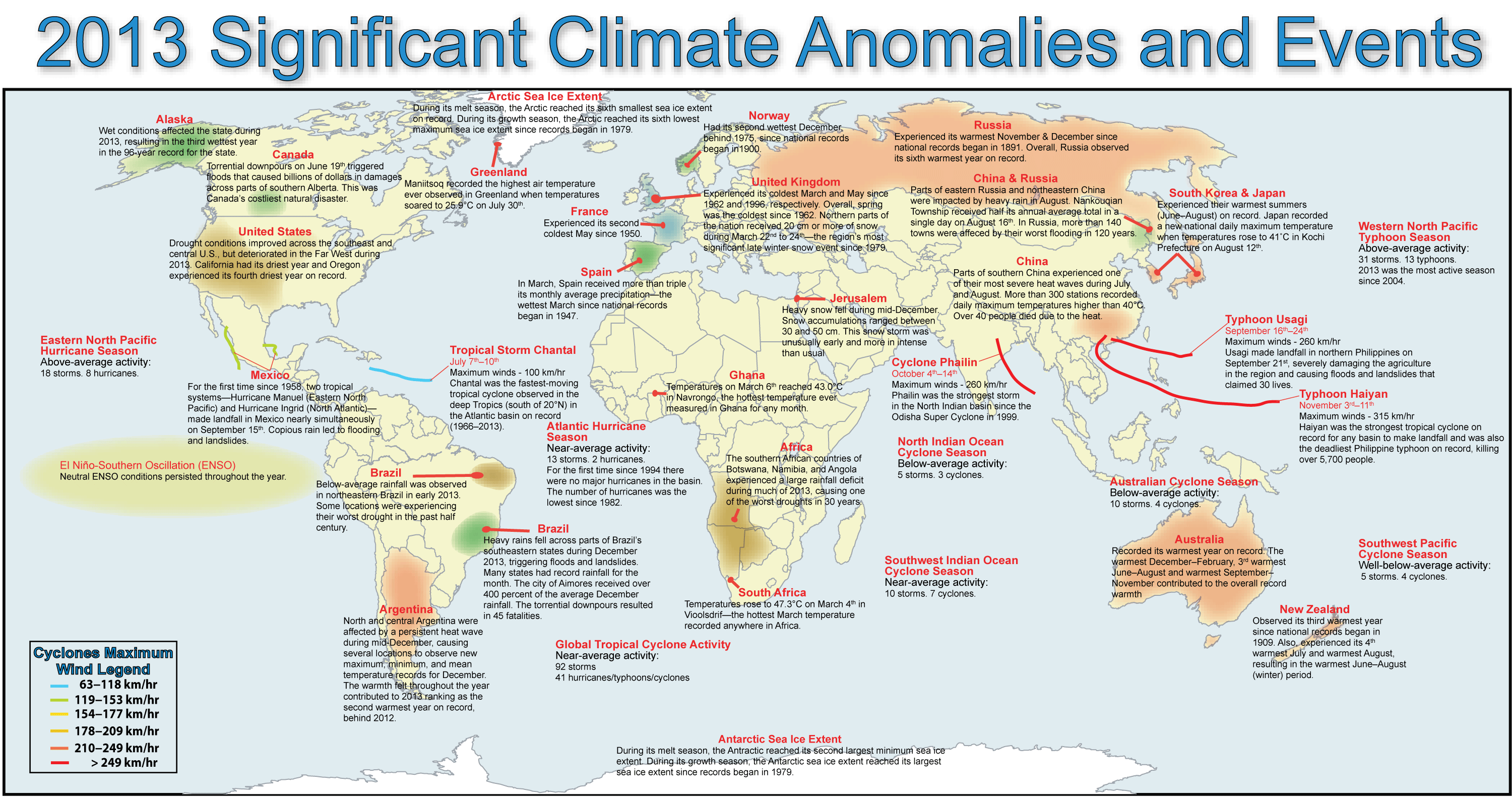
- Australia observed its warmest year in the country's 104-year period of record, with a nationally-averaged temperature that was 1.20°C (2.16°F) above the 1961–1990 average, easily surpassing the previous record set in 2005 by 0.17°C (0.31°F). Much of this warmth can be attributed to the record-warm summer (December 2012–February 2013) and spring (September–November 2013), with September having the largest temperature departure from average of any month since records began in 1910, at +2.75°C (+4.95°F). The warmth was also notable because it was widespread across the country, with every state and the Northern Territory ranking among their four warmest years on record.
- Finland had its sixth highest annual temperature since records began in 1847, with much of the country 1°–2°C (1.8°–3.6°F) above the 1981–2010 average.
- The 2013 global average ocean temperature was 0.48°C (0.86°F) above the 20th century average of 16.1°C (60.9°F), tying with 2006 as the eighth warmest year on record.
- ENSO-neutral conditions emerged in the central and eastern equatorial Pacific Ocean during the second half of 2012 and prevailed during all of 2013.
Some national highlights are included below:
2013 Precipitation highlights
- 2013 saw near-average precipitation on balance for land-based rain gauges around the globe, at just 0.31 mm (0.01 inch) above the 1961–1990 average of 1,033 mm (40.7 inches). However, precipitation varied greatly across regions.
-
- In early 2013, much-below-average rainfall was recorded in northeastern Brazil, where parts of the region were experiencing their worst drought in the past half century. In December, many states in southeastern Brazil observed record high rainfall. At least seven cities in the region set new single monthly precipitation records.
- In southern Africa, Botswana and Namibia experienced their worst droughts in 30 years during 2013.
- The Southwest Asian monsoon season had an early onset of June 16 over all of India and contributed to the worst flooding and devastation in the past half century to regions near the India-Nepal border. The monsoon arrived 15 days early in Uttarakhand, with constant rain during June 15–18. Northwest India received nearly double its average June rainfall. The flooding occurred during the peak tourist and pilgrimage season, killing thousands of people.
- From the end of July to mid-August 2013, unusually heavy rain fell near the Amur River, which marks the border between China and Russia. The river reached a record 100.56 m (329.92 ft), surpassing the previous record set in 1984, as heavy flooding hit parts of the region. The Songhuajiang and Liaohe River Basins in northeast China saw their heaviest floods since 1998. In eastern Russia, more than 140 towns were affected by their worst flooding in 120 years.
2013 snow and polar ice highlights
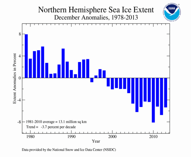
- For all of 2013, Arctic sea ice extent was below average, while Antarctic sea ice extent was above average. When examining both the Arctic and the Antarctic sea ice extents combined, the global sea ice extent was above average for eight of the 12 months of 2013. The December global sea ice extent was the fifth largest on record.
-
- On March 15, Arctic sea ice reached its annual maximum extent at 5.84 million square miles, which is 197,000 square miles below the 1981–2010 average maximum extent. The 2013 annual maximum extent was the sixth smallest on record. The 10 smallest maximum extents have occurred in the last 10 years, between 2004 and 2013.
- On September 13, Arctic sea ice reached its annual minimum extent. The annual minimum extent was 1.97 million square miles, marking the sixth smallest annual minimum extent on record. The 2013 minimum was 653,000 square miles larger than the record minimum extent that occurred on September 16, 2012 and about 432,000 square miles smaller than the 1981–2010 average.
- On September 22, the Antarctic sea ice extent reached its annual maximum. The annual maximum extent was 7.52 million square miles, marking the largest annual maximum extent on record. The 2013 maximum was about 11,600 square miles larger than the previous record large Antarctic annual maximum sea ice extent, which occurred in 2012, and 3.6 percent higher than the 1981–2010 average. The Antarctic sea ice extent set new records for largest monthly extents for each of the four months between August and November.
- The Northern Hemisphere winter (December 2012–February 2013) snow cover extent was 18.3 million square miles, which was 0.9 million square miles above the 1981–2010 average of 17.4 million square miles and the fourth largest seasonal snow cover extent for the hemisphere. Both North America and Eurasia had above-average winter snow cover extents. The winter seasons of 1977/78, 2009/10, and 2010/11 had larger Northern Hemisphere snow cover extents. Winter Northern Hemisphere snow cover has expanded at an approximate rate of 0.4 percent per decade.
- The Northern Hemisphere spring (March–May) snow cover extent was 11.64 million square miles, which was 151,000 square miles above the 1981–2010 average of 11.49 million square miles. This was the 23rd largest (25th smallest) spring snow cover extent on record for the Northern Hemisphere. North America had its 10th largest spring snow cover extent, while Eurasia had its 14th smallest spring snow cover extent. Spring Northern Hemisphere snow cover has shrunk at an approximate rate of 1.9 percent per decade.
Global temperature highlights: December
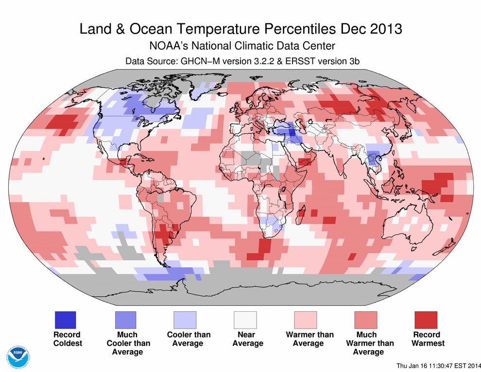
- The combined average temperature over global land and ocean surfaces for December was the third highest on record for December at 12.84°C (55.15°F), or 0.64°C (1.15°F), above the 20th century average. The margin of error is ±0.08°C (0.14°F).
- The global land temperature was 1.12°C (2.02°F) above the 20th century average of 3.7°C (38.7°F), tying with 1998 as the fifth warmest for December on record.
- For the ocean, the December global sea surface temperature was 0.46°C (0.83°F) above the 20th century average of 15.7°C (60.4°F), tying with 2004 as the seventh warmest for December on record.
 NOAA's National Centers for Environmental Information


