Monthly Report Summary Information
The Monthly Report Summary Information is a synopsis of the collection of national and global summaries released each month.
National Summary Information - August 2012
See Full Report
Contiguous U.S. experiences 3rd hottest summer on record
Warm and dry conditions continue in August; Isaac brings heavy rain to Gulf Coast and some drought relief to the Midwest
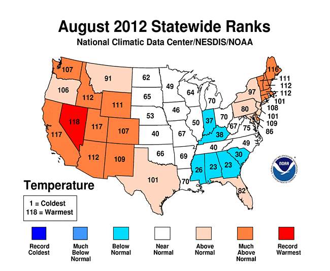
The average temperature for the contiguous U.S. during August was 74.4°F, 1.6°F above the long term average, marking the 16th warmest August on record. The warmer than average August, in combination with the hottest July and a warmer than average June, contributed to the third hottest summer on record since recordkeeping began in 1895.
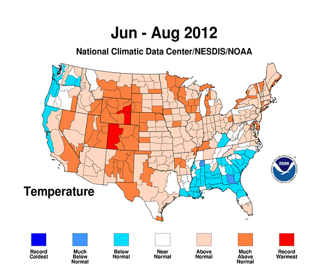
The summer season's (June-August) nationally-averaged temperature was 74.4°F, 2.3°F above the 20th century average. Only the summers of 2011 (74.5°F) and 1936 (74.6°F) had higher temperatures for the Lower 48.
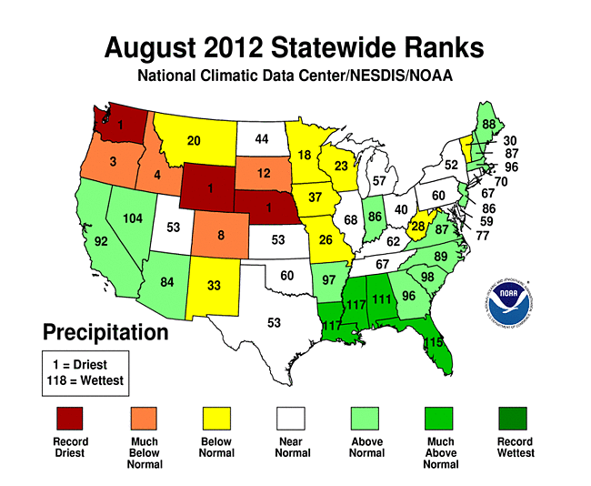
The August nationally-averaged precipitation total of 2.59 inches was near the long-term average. The Southwest and Southeast were wetter than average and the Northwest and the Northern Plains were drier than average. As of August 28th, according to the U.S. Drought Monitor, nearly 63% of the contiguous U.S. continued to experience drought conditions.
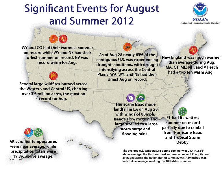
Significant climate events for August and Summer 2012. Click image to enlarge, or click here for the National Overview.
Note: The August Monthly Climate Report for the United States has several pages of supplemental information and data regarding some of the exceptional events from the month and season.
U.S. climate highlights: August
- Higher-than-average temperatures occurred across much of the West. Nevada tied August 1934 as its warmest August on record, with a statewide temperature 4.0°F above average. Six additional states across the region had August temperatures ranking among their ten warmest. Much of the Northeast was also warmer than average, where five states from Maine to Delaware had monthly temperatures among its ten warmest.
- Drier-than-average conditions stretched from the Pacific Northwest, through the Rockies, and into the Upper Midwest. Nebraska, Washington and Wyoming each had their driest August on record. Colorado, Idaho and Oregon each had a top ten dry August.
- Hurricane Isaac made landfall along Louisiana's coast on August 28th with maximum sustained winds of 80 mph. The major impacts from the hurricane were storm surge along the Gulf Coast and heavy rainfall, both of which were driven partially by the storm's slow motion and large size. Isaac contributed to Louisiana and Mississippi's second wettest August on record, as well Florida's fourth wettest and Alabama's eighth wettest. The storm also provided some relief to drought-stricken areas of the Midwest.
- The warm and dry conditions across much of the West were associated with another month of ideal wildfire conditions. Over 3.6 million acres burned nationwide, mostly across the West. The acreage burned was nearly twice the August average and the most for the month in the 12-year period record.
- According to the U.S. Drought Monitor update on August 28th, 2012 (the day Hurricane Isaac made landfall), 62.9% of the contiguous U.S. (CONUS) was experiencing moderate-to-exceptional drought, the same as the end of July. The percent area of the nation experiencing the worst drought category, exceptional drought, doubled from 3% of the CONUS at the end of July to 6% at the end of August.
- According to the Palmer Drought Index, which goes back to the beginning of the 20th century, 55.1% of the CONUS was in moderate to extreme drought, a decrease of about 3% compared to last month. The percent area in severe to extreme drought increased to 39.0%, indicating that the drought has intensified. The 2012 values have been exceeded only by the droughts of the 1930s and 1950s.
- A list of select August temperature and precipitation records can be found here.
U.S. climate highlights: Summer (June-August)
- The summer season was warmer than average for a large portion of contiguous United States (CONUS), with the exception of the Southeast and parts of the Northwest which were near or slightly cooler than average. There were sixteen states across the West, Plains, and Upper Midwest which had summer temperatures among their ten highest. Colorado and Wyoming each had their record hottest summer, with seasonal temperatures 4.4°F and 4.9°F above average, respectively. Much of the Northeast was warmer than average, where seven states from New Hampshire to Maryland had a top ten warm summer.
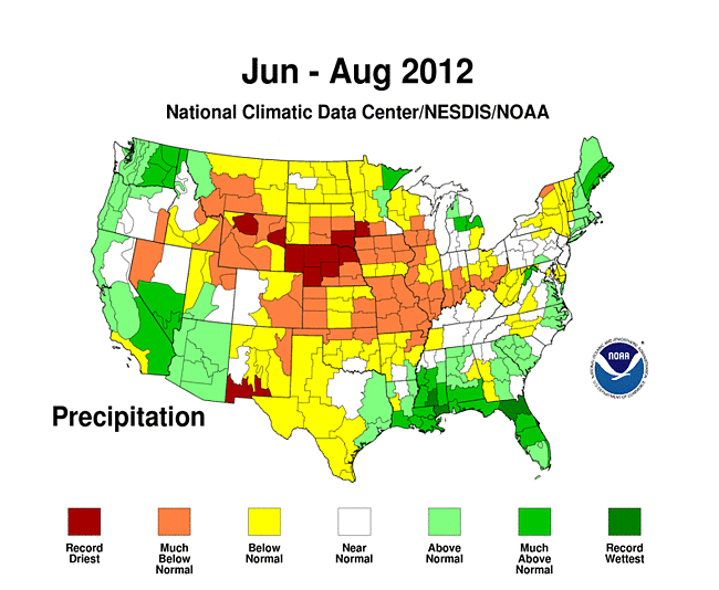
- Drier-than-average conditions prevailed across much of the central U.S., from the Rocky Mountains to the Ohio Valley. Nebraska's summer precipitation was 5.92 inches below its average of 9.46 inches, while Wyoming's precipitation was 2.30 inches below its average of 3.97, marking the driest summer on record for both states. Missouri, Illinois, Iowa, South Dakota, Nebraska, and New Mexico had summer precipitation totals among its ten driest.
- The nationally-averaged summer precipitation total of 7.39 inches, which was 0.86 inch below average, marked the 18th driest summer on record for the CONUS.
- The summer was wetter than average across the West Coast, the Gulf Coast, and New England. Florida had its wettest summer on record, partially driven by Hurricane Isaac in August and Tropical Storm Debby in June. The total statewide summer precipitation of 30.58 inches was 8.85 inches above the long term average. In addition, both Louisiana and Mississippi had one of their ten wettest summer seasons.
- The U.S. Climate Extremes Index (USCEI), an index that tracks the highest and lowest 10 percent of extremes in temperature, precipitation, drought and tropical cyclones across the CONUS, was more than one and a half times the average value during summer 2012, and marked the eighth largest USCEI value for the season. Extremes in warm daytime temperatures, warm nighttime temperatures, and extremely dry conditions, according to the Palmer-Drought Severity Index, covered large areas of the nation, contributing to the above average USCEI value.
U.S. climate highlights: year-to-date (January-August)
- The January-August period was the warmest first eight months of any year on record for the contiguous United States. The national temperature of 58.7°F was 4.0°F above the 20th century average, and 1.0°F above the previous record warm January-August of 2006. During the eight-month period, 33 states were record warm and an additional 12 states were top ten warm. Only Washington had statewide temperatures near average for the period.
- January-August 2012 was the 14th driest such period on record for the contiguous United States with a precipitation total 1.9 inches below the average of 20.2 inches. Drier-than-average conditions stretched from the West across the heart of the nation into the Northeast with ten states having year-to-date precipitation totals among their ten driest.
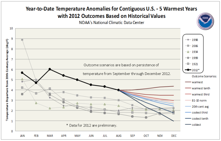
This graphic shows the calendar-year temperature outcomes based upon observed January-through-August temperatures, and eight historical scenarios for September-through-December. Click here for more information.
 NOAA's National Centers for Environmental Information
