Monthly Report Summary Information
The Monthly Report Summary Information is a synopsis of the collection of national and global summaries released each month.
National Summary Information - January 2013
See Full Report
Contiguous U.S. warmer and wetter than average for January
Drought persists for central U.S.; above-average January snow cover extent for Lower 48
The average temperature for the contiguous U.S. during January was 32.0°F, 1.6°F above the 20th century average, tying with 1958 as the 39th warmest January on record.
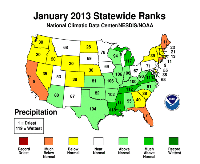
The January nationally-averaged precipitation total of 2.36 inches was 0.14 inch above the long-term average. The January precipitation average masked both wet and dry extremes across nation. Drought conditions remained entrenched across the Southeast, Great Plains, and the mountainous West.
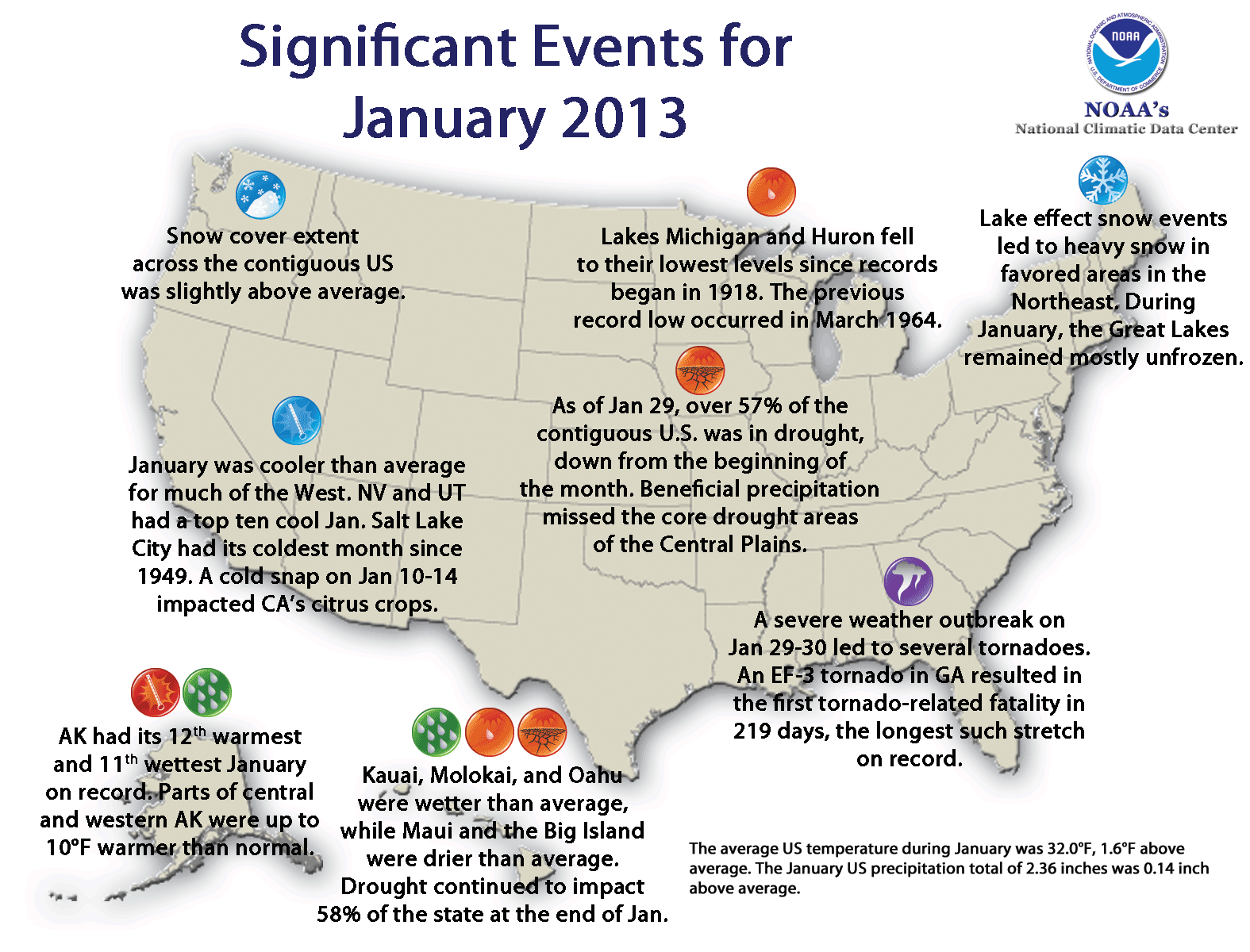
Significant climate events for January 2013.
Click image to enlarge, or click here for the National Overview.
Note: The January Monthly Climate Report for the United States has several pages of supplemental information and data regarding some of the weather/climate events from the month.
U.S. climate highlights: January
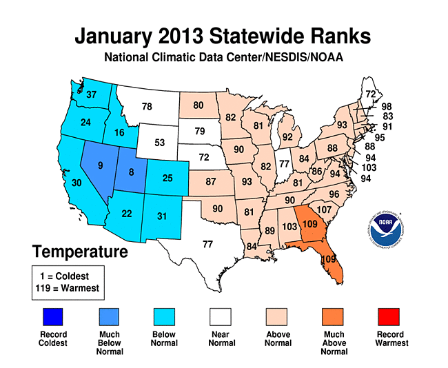
- January brought Florida both had their 11th warmest January with monthly temperatures 5.7°F and 5.6°F above average, respectively.
- Utah had its eighth coolest January with temperatures 7.5°F below average.
- Virginia each had January precipitation totals ranking among their ten wettest. The above-average precipitation generally missed the core drought areas of the central and southeastern United States.
- Florida each had one of their ten driest January.
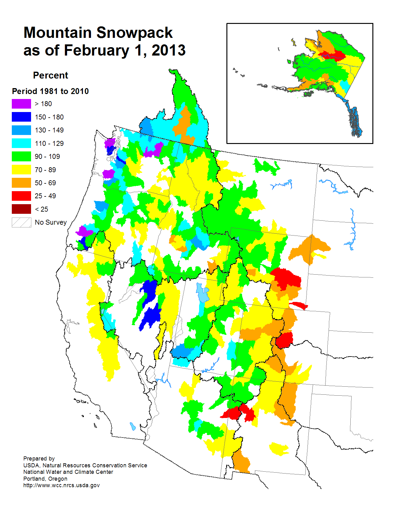
- According to data from the Rutgers Global Snow Lab, the January snow cover extent for the contiguous U.S. was above average at 1.4 million square miles. Mountain snowpack was near-average for much on the West, with the exceptions of the Northwest where snowpack was much above average, and the Central and Southern Rockies where snowpack was much below average.
- Alaska was warmer and wetter than average. The statewide average temperature was 7.1°F above average and the precipitation total was 64 percent above average. Parts of the state had monthly temperatures more than 10°F above normal.
- According to the January 29 U.S. Drought Monitor report, 57.7 percent of the contiguous U.S. was experiencing moderate-to-exceptional drought, smaller than the 61.1 percent at the beginning of the month. Drought conditions improved in parts of the Mid-Atlantic and Mid-Mississippi River Valley.
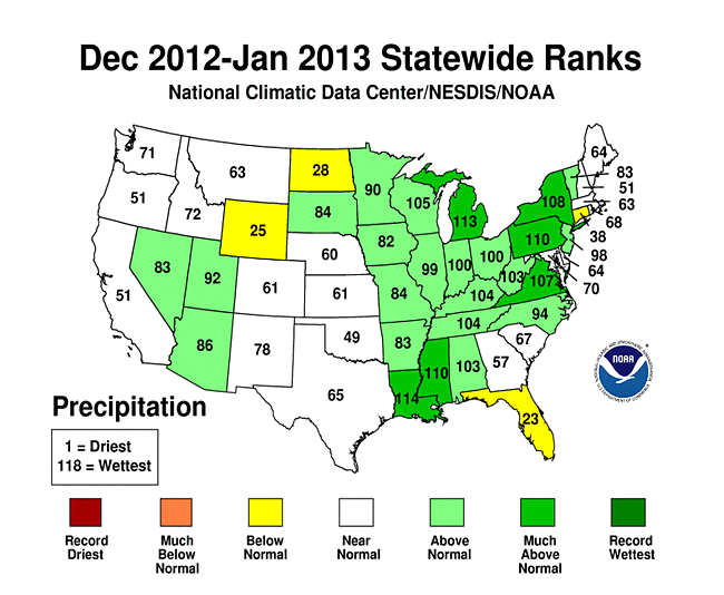
U.S. climate highlights: Winter-to-Date (December 2012 — January 2013
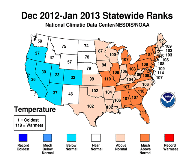
Winter-to-Date 2013 Statewide Temperature ranks
- The first two months of the winter season, December and January, were warmer than average for the contiguous United States and ranked as the 18th warmest such period on record. The two-month period had an average temperature 2.5°F above average. Much of the warmth occurred across the eastern half of the nation. The West Coast and Southwest were slightly cooler than average during the 2-month period.
- An active storm pattern in the eastern U.S. resulted in wetter-than-average conditions during the first two months of winter. Louisiana, Mississippi, Michigan, and Pennsylvania each had a top ten wet period. The nationally-averaged precipitation total for the two-month period was 5.10 inches, 0.65 inch above average.
U.S. climate highlights: Last 12 months (February 2012 — January 2013
- The 12-month period, ending in January, was the warmest such period for the contiguous U.S., with ninth warmest of any 12-month period on record for the nation.
- The nationally-averaged precipitation total of 26.95 inches for the February-January period was 2.19 inches below average. Much of the Louisiana had a top ten wet period.