Monthly Report Summary Information
The Monthly Report Summary Information is a synopsis of the collection of national and global summaries released each month.
National Summary Information - October 2016
See Full Report
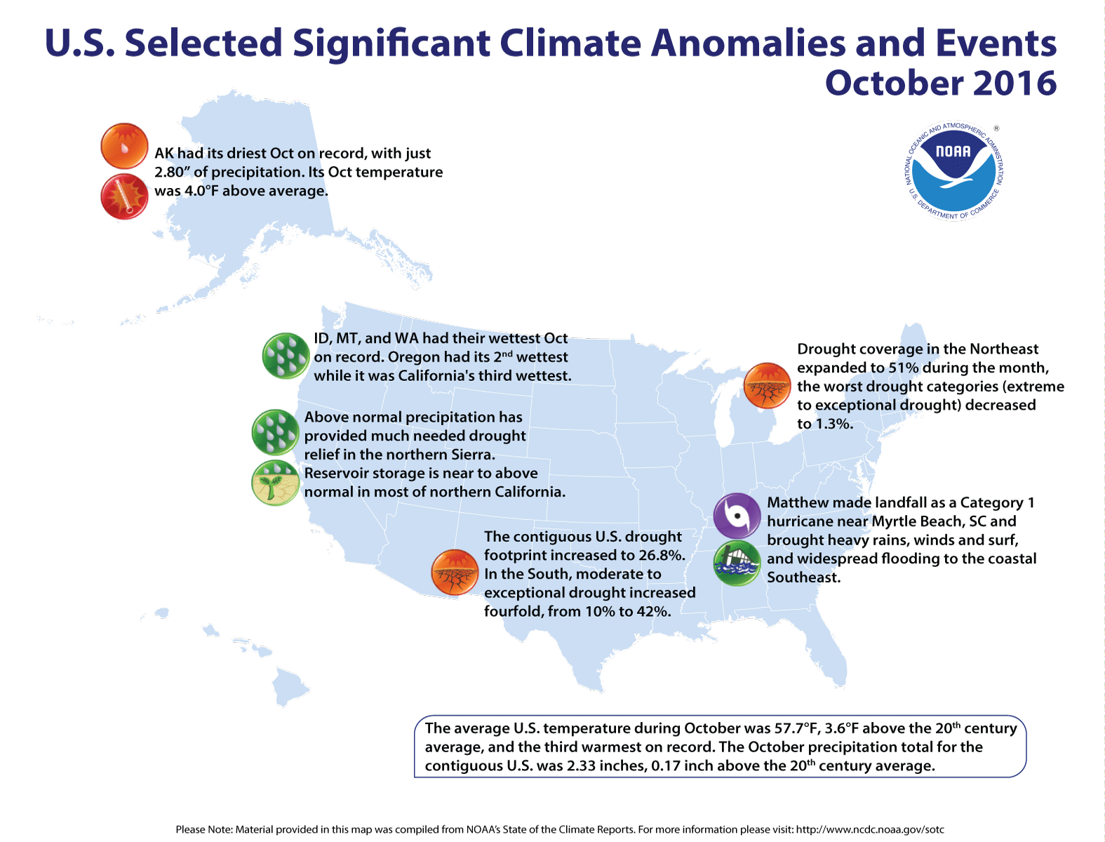
Significant climate events for October 2016
U.S. had its third warmest October and second warmest year to date
The contiguous U.S. October average temperature was 57.7°F, 3.6°F above the 20th century average, making it the third warmest October in the 122-year period of record and the warmest since 1963. The last three Octobers are among the six warmest in the 122-year record. The year-to-date (January-October) contiguous U.S. average temperature was 57.8°F, 2.8°F above average, making it the second warmest on record, behind only 2012.
The October precipitation total for the contiguous U.S. was 2.33 inches, 0.17 inch above the 20th century average, and ranked near the middle of the 122-year period of record. Wet conditions dominated the Pacific Northwest and the coastal Southeast. Dry conditions prevailed in the South and the interior Southeast, where drought intensified significantly during October. The year-to-date (January-October) contiguous U.S. precipitation total was 27.16 inches, 1.80 inches above average, and the 21st wettest year to date on record.
This analysis of U.S. temperature and precipitation is based on data back to January 1895, resulting in 122 years of data.
Supplemental October 2016 Information
U.S. climate highlights: October
Temperature
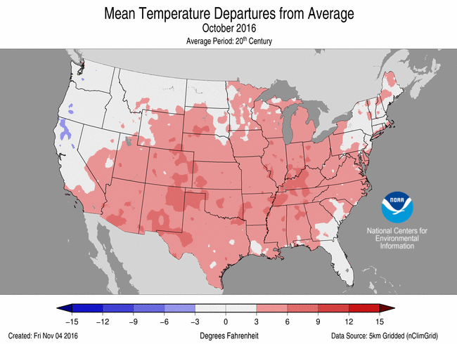
- Temperatures across most of the country were much above average during October. New Mexico had it warmest October on record with an average temperature that was 5.8°F above the 20th century average. Texas had its second warmest October, while Arizona, Colorado and Oklahoma each had their third warmest. Only three states, Montana, Oregon and Washington, were near average.
- Over the last 30 years, average October temperatures for the contiguous U.S. have warmed by 0.65°F per decade. Only September has warmed more (+0.74°F per decade).
- As has been the case for much of the decade, minimum (nighttime) temperatures were relatively warmer than normal, compared to maximum (daytime) temperatures.
- The contiguous U.S. average maximum (daytime) temperature during October was 69.9°F, 3.1°F above the 20th century average, the sixth warmest on record. Above average maximum temperatures occurred across much of the southern and southeastern U.S. Near average maximum temperatures were observed in parts of the West and Northern High Plains. Below average maximum temperatures were confined to the Northwest.
- The contiguous U.S. average minimum (nighttime) temperature during October was 46.2°F, which is 4.8°F above the 20th century average, the second warmest on record. No state in the Lower 48 observed near average or below average October minimum temperatures.
- During October there were 7,025 record warm daily high (3,147) and low (3,878) temperature records. This was more than 10 times the 508 record cold daily high (316) and low (192) temperature records.
Precipitation

October 2016 Temperature Departure from Average
(top) and Precipitation Percent of Average (bottom)
- Above-average precipitation was observed across parts of the West and Northwest. Idaho, Montana and Washington each had their wettest October on record. Oregon had its second wettest October, and California had its third wettest. In contrast, Alaska had its driest October on record; statewide records for Alaska begin in 1925.
- Below-average precipitation continued for the second consecutive month in areas of the South. Alabama, Louisiana, Mississippi, Tennessee and Texas had one of their 10 driest Octobers on record. Separately, Colorado had its 10th driest October.
- Rainfall associated with Hurricane Matthew represented a notable exception to the prevailing dry conditions in the southern and eastern U.S.
- Hurricane Matthew formed in the Caribbean and quickly became a Category 5 hurricane, the first in the Atlantic since Hurricane Felix in 2007. Matthew skirted Florida's Atlantic coastline before making landfall as a Category 1 storm just south of Myrtle Beach, South Carolina, on October 8.
- Inland flooding associated with Matthew was especially severe in coastal Georgia, the eastern Carolinas and southeastern Virginia. The region suffered monumental agricultural losses to poultry, orchards, vegetable and fiber crops.
- According to the November 1 U.S. Drought Monitor report, drought increased from 19.4 percent of the contiguous U.S. in early October to 26.8 percent by the end of the month. The majority of the expansion occurred in the South and Southeast where many locations did not receive any precipitation during the month of October. In the South, the drought footprint quadrupled, from 10 percent coverage to 42 percent coverage, while in the Southeast it increased from 25 percent to 39 percent.
U.S. climate highlights: year-to-date (January-October)
Temperature

- Every state in the contiguous U.S. and Alaska observed much-above-average temperatures for the first 10 months of the year. Thirty-seven states marked one of their five warmest January-October periods on record. Alaska, North Carolina and South Carolina were record warm for the period.
- The year's most profound warmth in the U.S., by far, has occurred in Alaska. Its year-to-date temperature of 36.3°F is 6.7°F above average, surpassing the previous record warm January-October of 1926 by 2.5°F. Record and near-record warmth has engulfed Alaska for much of 2016.
Precipitation
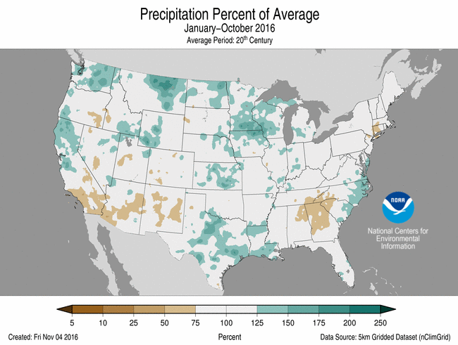
Jan-Oct Temperature Departure from Average
(top) and Precipitation Percent of Average (bottom)
- Above-average precipitation has fallen across much of the northern U.S. where Michigan and Minnesota each had their second wettest year-to-date. Conversely, dryness has prevailed in New England during 2016. Connecticut had its seventh driest January-October period.
Extremes
- The U.S. Climate Extremes Index (USCEI) for the year to date was 65 percent above average and the fifth highest value on record. On the national scale, extremes in warm maximum and minimum temperatures, the spatial extent of wetness and one-day precipitation totals were above average. The USCEI is an index that tracks extremes (falling in the upper or lower 10 percent of the record) in land-falling tropical cyclones, temperature, precipitation and drought across the contiguous U.S.
For extended analysis of regional temperature and precipitation patterns, as well as extreme events, please see our full report that will be released on October 12th.