|
PLEASE NOTE: The ranks and temperature anomalies in this report represent the values known at the time the report was issued. The actual ranks will change as subsequent years are added to the dataset. The anomalies themselves may change slightly as missing or erroneous data is resolved. Also, in 2009, NCDC switched to ERSST version 3b (from version 2) as a component of its global surface temperature dataset. Because the versions have slightly different methodologies, the calculated temperature anomalies will differ slightly. For more information about this switch please see the Global Surface Temperature Anomalies FAQ . |
Global Temperatures |
| The global annual temperature for combined land and
ocean surfaces in 2006 was +0.54°C (+0.97°F) above average,
ranking 5th warmest in the period of record. However, uncertainties
in the global calculations due largely to gaps in data coverage
make 2006 statistically indistinguishable from 2005 and several
other recent warm years as shown by the error bars on the global
time series. Globally averaged land temperatures were
+0.78°C (+1.40°F) and ocean temperatures +0.45°C
(+0.81°F) above average, ranking 4th and 5th warmest,
respectively. The land and ocean surface temperatures for the
Northern and Southern Hemisphere ranked 2nd and 6th warmest,
respectively. The year began with ENSO in a weak cold phase (La Niña) which had developed during late 2005, and the presence of these La Niña conditions in the equatorial Pacific contributed to the lower global average temperature this year. By April and May 2006, the near-equatorial SST anomalies had warmed to near-normal in the central Pacific region as the ENSO transitioned to a neutral phase. El Niño conditions developed in September, and by the end of December, sea surface temperatures in most of the central and eastern equatorial Pacific were more than 1.0°C (1.8°F) above average. This El Niño event is likely to persist through May 2007, according to the latest information from NOAA's Climate Prediction Center. For more information on the state of ENSO during 2006, please see the ENSO monitoring annual summary. |
| January-December | Anomaly | Rank | Warmest Year on Record |
|---|---|---|---|
GlobalLandOcean Land and Ocean |
+0.78°C (+1.40°F) +0.45°C (+0.81°F) +0.54°C (+0.97°F) |
4th warmest 5th warmest 5th warmest |
2005 (+0.97°C/1.75°F) 2003 (+0.48°C/0.86°F) 2005 (+0.61°C/1.10°F) |
Northern HemisphereLandOcean Land and Ocean |
+0.87°C (+1.57°F) +0.49°C (+0.88°F) +0.63°C (+1.13°F) |
3rd warmest 4th warmest 2nd warmest |
2005 (+1.02°C/1.84°F) 2005 (+0.54°C/0.97°F) 2005 (+0.72°C/1.30°F) |
Southern HemisphereLandOcean Land and Ocean |
+0.54°C (+0.97°F) +0.43°C (+0.77°F) +0.44°C (+0.79°F) |
6th warmest 5th warmest 6th warmest |
2005 (+0.83°C/1.49°F) 1998 (+0.50°C/0.90°F) 1998 (+0.54°C/0.97°F) |
| **The 1901-2000 average combined land and ocean annual temperature is 13.9°C (56.9°F), the annually averaged land temperature for the same period is 8.5°C (47.3°F), and the long-term annually averaged sea surface temperature is 16.1°C (60.9°F). |
Regional Temperatures |
| Warmer than average conditions occurred throughout most land areas of the world again in 2006. The largest anomalies were present throughout high latitude regions of the Northern Hemisphere including much of North America, Scandinavia, China and Africa. Temperatures in these regions were 2-4°C (3.6-7.2°F)* above the 1961-1990 average. The only widespread area of negative anomalies occurred in central Russia. |
 larger image |
 larger image |
| The map, above left, is created using data from the Global Historical Climatology Network (GHCN), a network of more than 7,000 land surface observing stations. The map, above right, is a product of a merged land surface and sea surface temperature anomaly analysis developed by Smith and Reynolds (2005). Temperature anomalies with respect to the 1961-1990 mean for land and ocean are analyzed separately and then merged to form the global analysis. Additional information on this product is available. |
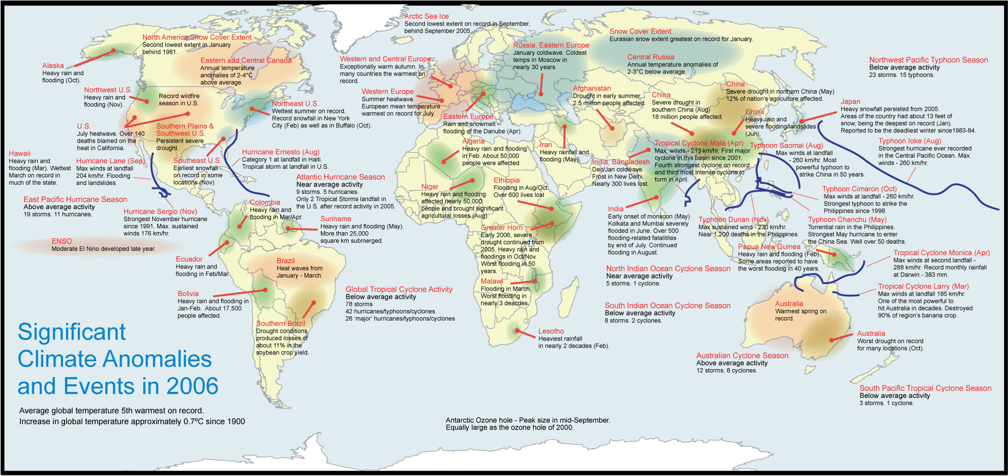
| Notable temperature extremes in 2006 included a
heat wave that affected a large portion of the United States during
July 16-25. California was particularly affected, with 140 deaths
attributed to high temperatures soaring past 40°C (104°F).
Hot weather also enveloped much of Europe during mid-to-late July,
with temperatures surpassing 32°C (90°F). In Britain, on
the afternoon of July 19th, temperatures reached 36.5°C
(97.7°F) at Wisley, the hottest July temperature ever recorded
in Britain. By late July across Europe, at least 50 deaths were
blamed on the heat in Spain, France, Italy and the Netherlands. In India, frost was observed in New Delhi for the first time in 70 years as cold air flowing from the Himalayas produced a low temperature of 0.2°C (32.3°F) on January 9th. The record low occurred on January 16, 1935, when -0.6°C (31°F) was reported. In Russia, a severe cold wave, which arrived during January 17-18, brought some of the coldest temperatures to the region in decades. Moscow temperatures plummeted to -30°C (-22°F), the coldest readings since the winter of 1978-1979, when temperatures dropped to -38°C (-36°F). In June, unseasonably cold temperatures affected areas of Australia, with many locations breaking their all-time record minimum temperatures for the month. Averaged across Australia as a whole, it was the fourth coldest June in the post-1950 record. Additional information on other notable weather events can be found in the Significant Events section of this report. |
Global Precipitation |
 larger image  larger image |
Global precipitation
in 2006 was much above the 1961-1990 average, the largest value in
five years. Regionally drier than
average conditions were widespread across the U.S. Great Plains
and Gulf Coast regions, the western coast of Canada and most of
Australia. While the northeast U.S., Amazon Basin, India and Alaska
all experienced wetter than average conditions. A severe long-term drought continued throughout southern Ethiopia, southern Somalia, northeastern Kenya, as well as adjacent areas of eastern Uganda and Tanzania for most of the year. In February, drought in Somalia was characterized as the worst in a decade. In all, an estimated 11 million people in East Africa and the Horn of Africa continued to face critical food shortages brought about in part by the continuing drought despite the welcome rainfall that began in June. |
| In May, drought in China threatened the drinking
water supply for nearly 14 million people in the northern part of
the country. About 16.3 million hectares (40 million acres) of
agriculture land, more than 12 percent of the nation's total, was
affected by drought. On Leyte Island, in the Philippines, approximately 20 inches (500 mm) of rain fell during the first half of February, leading to more than 1000 lives lost when the village of Guinsaugon was buried by a landslide. The Philippines was also affected by five landfalling typhoons in 2006, including Super Typhoon Durian which hit the southeastern part of the island on November 30. During June, southern China received rainfall rates on the order of 99 mm (3.5 inches) in two hours forcing the Bashili River out of its banks and flooding 11 villages in the Fujian province. The Chinese government characterized the summer flooding as the worst in 30 years in parts of the country, with 349 weather-related deaths in June. For more information about precipitation extremes during 2006, see the annual report of Significant Events. Additional information on other notable weather events can be found in the Significant Events section of this report. |
| NOAA's National Climatic Data Center is the
world's largest active archive of weather data. The
temperature and precipitation rankings are
available from the center by calling: 828-271-4800. NOAA works closely with the academic and science communities on climate-related research projects to increase the understanding of El Niño and improve forecasting techniques. NOAA's Climate Prediction Center monitors, analyzes and predicts climate events ranging from weeks to seasons for the nation. NOAA also operates the network of data buoys and satellites that provide vital information about the ocean waters, and initiates research projects to improve future climate forecasts. |
References:Peterson, T.C. and R.S. Vose, 1997: An Overview of the Global Historical Climatology Network Database. Bull. Amer. Meteorol. Soc., 78, 2837-2849. Quayle, R.G., T.C. Peterson, A.N. Basist, and C. S. Godfrey, 1999: An operational near-real-time global temperature index. Geophys. Res. Lett., 26, 333-335. Smith, T.M., and R.W. Reynolds (2005), A global merged land air and sea surface temperature reconstruction based on historical observations (1880-1997), J. Clim., 18, 2021-2036. |