National Overview

April Highlights
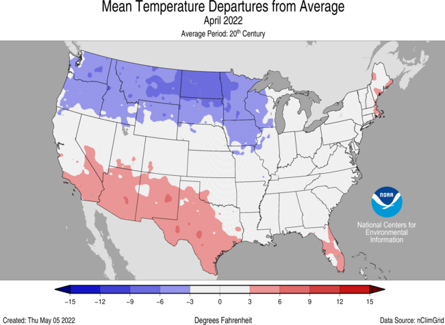
April Temperature
- During April, the average temperature of the contiguous U.S. was 50.7°F, 0.4°F below the 20th-century average, ranking in the middle third of the 128-year period of record.
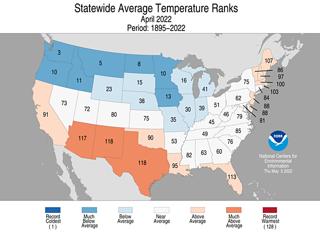
- Generally, temperatures from the Northwest to the Great Lakes and into the mid-Mississippi Valley were below average, with much of the Southwest, Deep South and portions of the East Coast above average. Washington state ranked third coldest on record for April while Montana ranked fifth coldest.
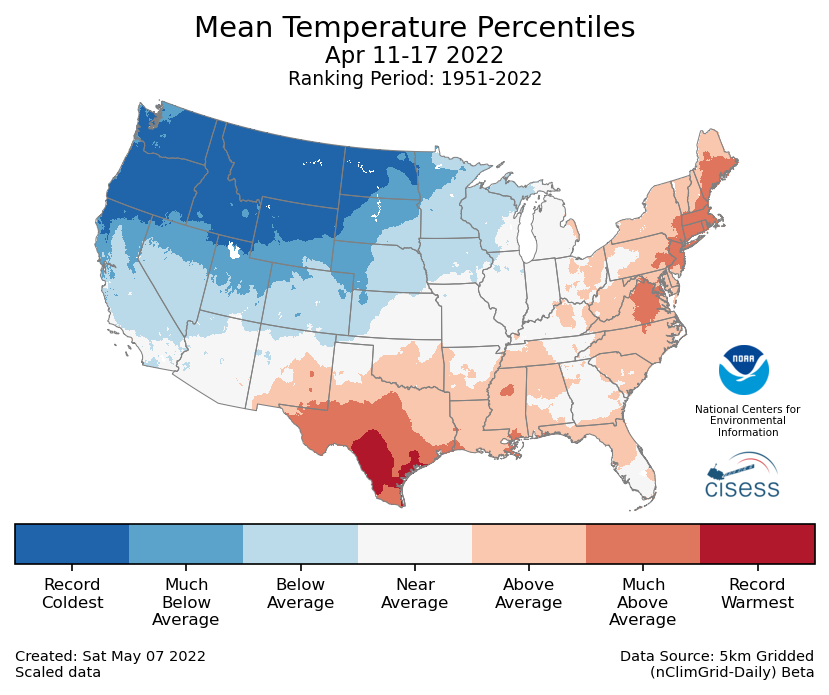
- From April 11-17, a broad trough across the Pacific Northwest contributed to the influx of Arctic air that resulted in the coldest temperatures observed across much of the Pacific Northwest and the northern Rockies and northern Plains since at least the mid-20th century during this period.
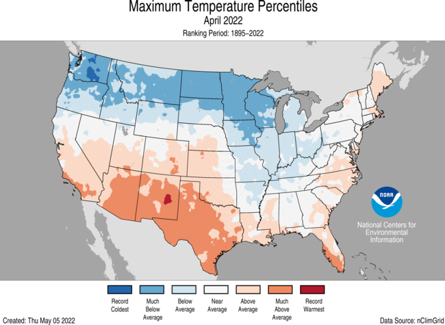
- The contiguous U.S. average maximum (daytime) temperature during April was 63.3°F, 0.2°F below the 20th-century average, ranking in the middle third of the historical record. Above-average conditions were observed from central and southern California to the central and southern Plains as well as along portions of the East Coast. Arizona ranked seventh warmest on record for April. Below-average maximum temperatures were observed from the Pacific Northwest to the Great Lakes and into the mid-Mississippi Valley. Washington state ranked fourth coldest April on record for daytime temperatures.
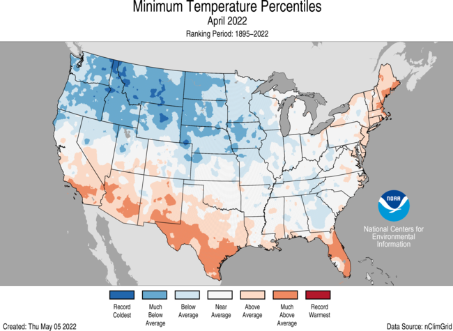
- The contiguous U.S. average minimum (nighttime) temperature during April was 38.1°F, 0.5°F below the 20th-century average, ranking in the coldest third of the historical record. Above-average conditions were observed across portions of the Southwest, Deep South, Gulf Coast and Northeast. Below-average minimum temperatures were observed from the Pacific Northwest to the Great Lakes and into portions of the Southeast. Montana ranked third coldest on record for April while Idaho ranked fifth coldest.
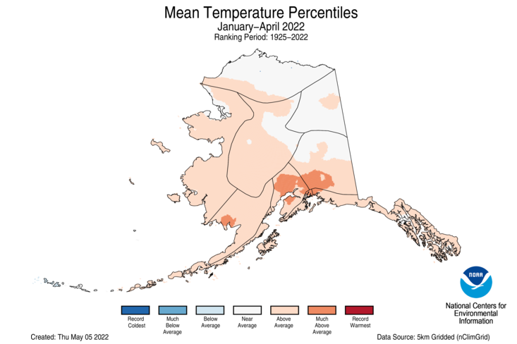
- The Alaska statewide April temperature was 25.2°F, 1.9°F above the long-term average. This ranked among the middle one-third of the 98-year period of record for the state. Temperatures were below average across much of the Southeast Interior and Panhandle regions and above average across much of the West Coast and Aleutian regions.
- During April across all 50 states, there were nearly 2.8 times as many cold daily records as compared with warm records. As of May 11, there were 2,211 record warm daily high (962) and low (1,249) temperature records and 6,151 record cold daily high (3,534) and low (2,617) temperature records.
- Based on NOAA's Residential Energy Demand Temperature Index (REDTI), the contiguous U.S. temperature-related energy demand during April was 110 percent of average and ranked 53rd highest in the 128-year period of record.
April Precipitation
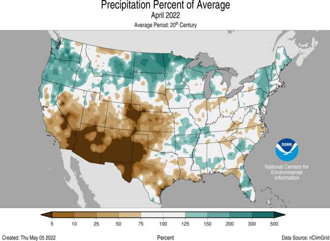
- The April precipitation total for the contiguous U.S. was 2.58 inches, 0.06 inch above average, ranking in middle third of the 128-year period of record.
- Precipitation was above average across portions of the Northwest, northern Rockies and Plains, Great Lakes and Northeast and below average across the Southwest as well as the central and southern Plains.
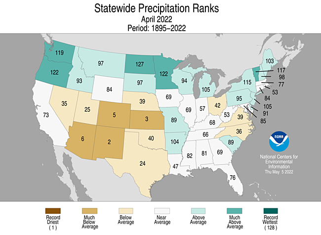
- Multiple late-season snow events contributed to a wet April for North Dakota, which reported its second-wettest such month on record. Oregon and Minnesota ranked seventh-wettest. In contrast, New Mexico had its second-driest April on record and Kansas ranked third driest.
- The late-season winter storms brought blizzard conditions to the Northern Rockies and Plains during April with reports of 1-2 feet of snow and drifts 4-8 feet from Montana to the Dakotas. A late season nor’easter brought more than a foot of snow to portions of the Northeast in mid-April.
- Several tornado outbreaks occurred during April, contributing to an above-average tornado count for April.
- Severe weather across the Southeast on April 5 produced more than 100 reports of tornadoes, including an EF4 tornado in Pembroke, GA.
- On April 12, severe storms across central Texas produced a 5.6-inch diameter hailstone and an EF3 tornado in Salado, TX.
- Severe weather across the Plains on April 29 produced tornadoes in Nebraska and Kansas, including an EF3 in Andover, KS.
- According to the May 3 U.S. Drought Monitor report, 53.8 percent of the contiguous U.S. was in drought, down about 4 percentage points from the end of March. Drought conditions expanded or intensified across portions of the West, central Plains and Deep South. Drought contracted or was eliminated across portions of the lower Mississippi Valley, the Great Lakes, the Northern Rockies and Plains, and Pacific Northwest, and across portions of Hawaii.
- Dry and windy conditions across the Southwest and Plains contributed to an active start to the wildfire season. As of May 3, the largest fire across the U.S., the Hermits Peak Fire in New Mexico, consumed more than 145,000 acres and was 20 percent contained. Across all 50 states, 1.1 million acres have burned from January 1 through May 3 — 160% of average for this time of year.
- On April 29, a NOAA satellite captured visible images of the wildfires in New Mexico and a Colorado dust storm resulting from dry conditions and strong winds that occurred across the High Plains.
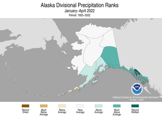
- April is climatologically one of the driest months of the year across Alaska. Even so, the state of Alaska, as a whole, ranked as the fourth-driest April in the 98-year record. All regions other than the North Slope received below-average precipitation for the month.
Year-to-Date Highlights
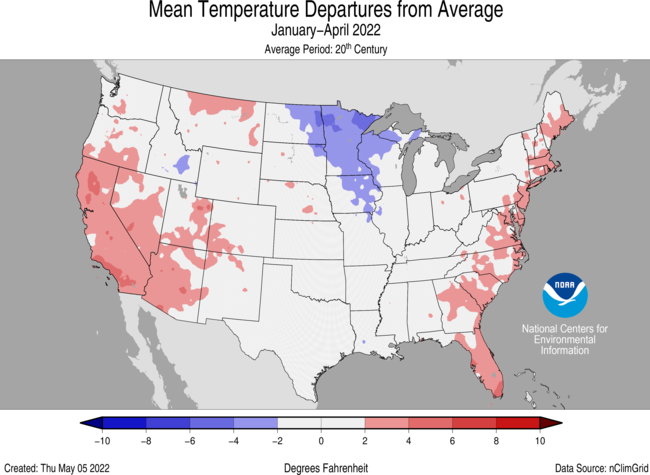
January-April Temperature
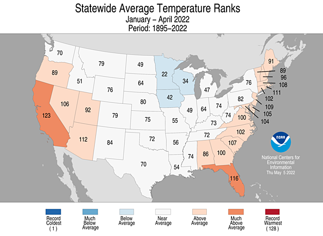
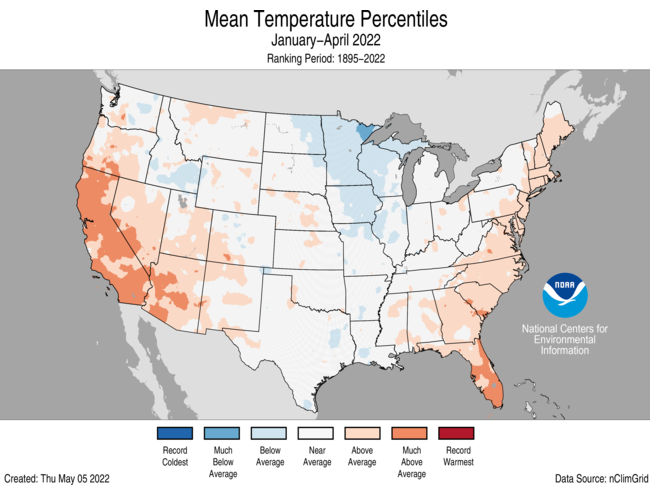
- The year-to-date (January-April) average contiguous U.S. temperature was 39.9°F, 0.8°F above average, ranking in the warmest third of the record.
- Temperatures were above average across parts of the West and also along the East Coast while below-average temperatures occurred in parts of the Upper Mississippi Valley and Great Lakes. California ranked sixth warmest on record for this period.
- The contiguous U.S. average maximum (daytime) temperature during January-April was 52.3°F, 1.8°F above the 20th-century average, ranking in the warmest third of the historical record. Above-average conditions blanketed an area from the West Coast to the Plains and from the Gulf Coast to New England. California ranked fourth warmest for daytime temperatures in April. Temperatures were below average across parts of the middle and lower Mississippi Valley and southern Plains.
- The contiguous U.S. average minimum (nighttime) temperature during January-April was 27.5°F, 0.3°F below the 20th-century average, ranking in the middle third of the record. Above-average temperatures were observed across parts of the West and along the East Coast. Temperatures were below average from the Deep South to the Upper Mississippi Valley and across portions of the Rockies.
- The Alaska January-April temperature was 13.5°F, 3.3°F above the long-term average, ranking in the warmest third of the record for the state. Above-average temperatures were observed across much of the western and southern half of the state with the warmest departures from average occurring in portions of south-central Alaska.
- Based on REDTI, the contiguous U.S. temperature-related energy demand during January-April was 82 percent of average and was the 35th-lowest value on record.
January-April Precipitation
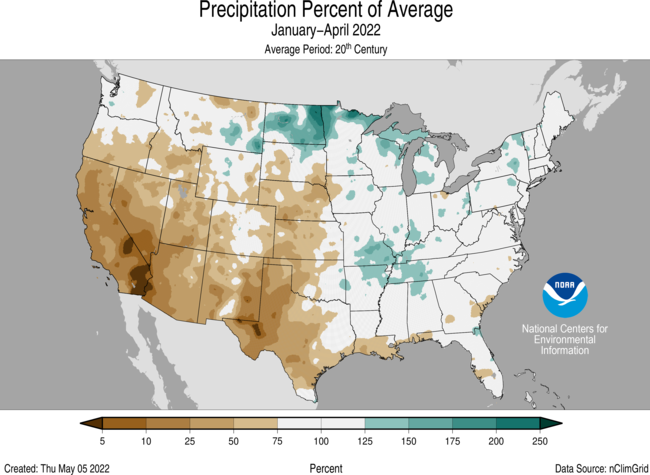
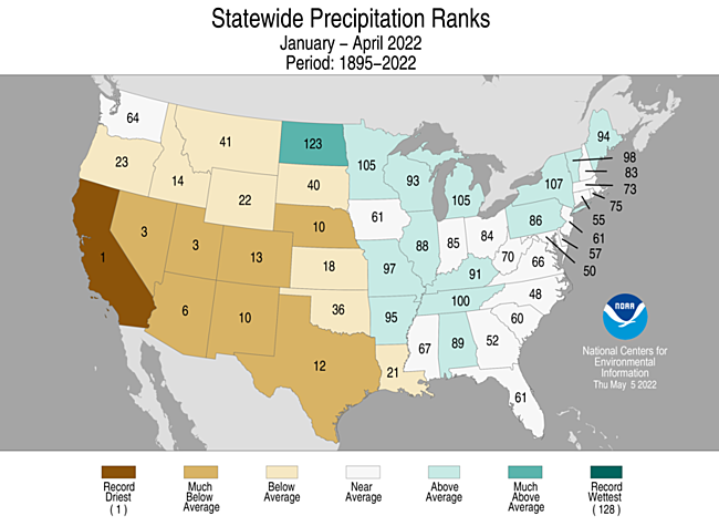
- The year-to-date national precipitation total was 8.25 inches, 1.22 inches below average, ranking 13th driest in the January-April record.
- Precipitation was above average across parts of the northern Plains, Great Lakes, mid-Mississippi Valley and the Northeast. Precipitation was below average across much of the West, central Plains and Deep South during the January-April period. California ranked driest on record while Nevada and Utah ranked third driest for this four-month period.
- Despite a dry April, precipitation averaged across Alaska for the January-April period ranked eighth wettest and was generally above average from Bristol Bay to the Panhandle with the Central Panhandle region experiencing its wettest January-April on record.
Extremes
-
The U.S. Climate Extremes Index (USCEI) for the year-to-date period was 6 percent above average and ranked in the middle third of the 113-year period of record. Extremes in dry PDSI were third highest on record for the January-April period while other indicators were either near or below average for the CONUS as a whole. The USCEI is an index that tracks extremes (falling in the upper or lower 10 percent of the record) in temperature, precipitation and drought across the contiguous United States.
- On the regional scale, the West and Northwest regions had CEI values that were much-above average. Across the West, elevated extremes in warm maximum temperature, dry PDSI values, as well as days without precipitation contributed to the elevated CEI value. For the Northwest, extremes in dry PDSI values, 1-day precipitation and elevated extremes in days with and without precipitation help illustrate the stark contrast in conditions west of the Cascades, where precipitation has been steady, and east of the Cascades, which experienced a record extent in the number of days without precipitation during the first four months of 2022. The CEI composite value for the Southeast region was 39 percent below average during this period, ranking 34th lowest on record.
- The preliminary count of 209 tornadoes reported in April was 135 percent of the 1991-2010 average of 155 tornadoes. For the year-to-date period, the preliminary count of 565 tornadoes is approximately 189 percent of average and the highest tornado count observed for the January-April period since 2017.
Monthly Outlook
- According to the April 30 One-Month Outlook from the Climate Prediction Center, parts of the Northern Tier have the greatest chance of receiving below-normal temperatures in May, whereas the greatest chance for above-normal temperatures is projected to occur from the Southwest to the Southeast and into portions of southern New England. An area from the Northwest to the central Plains is projected to have the greatest chance of above-normal precipitation, while the greatest chance for below-normal precipitation is expected to occur from the central West Coast to the western Gulf of Mexico. Drought is likely to persist over much of the West with some improvement expected across portions of the Plains and East Coast.
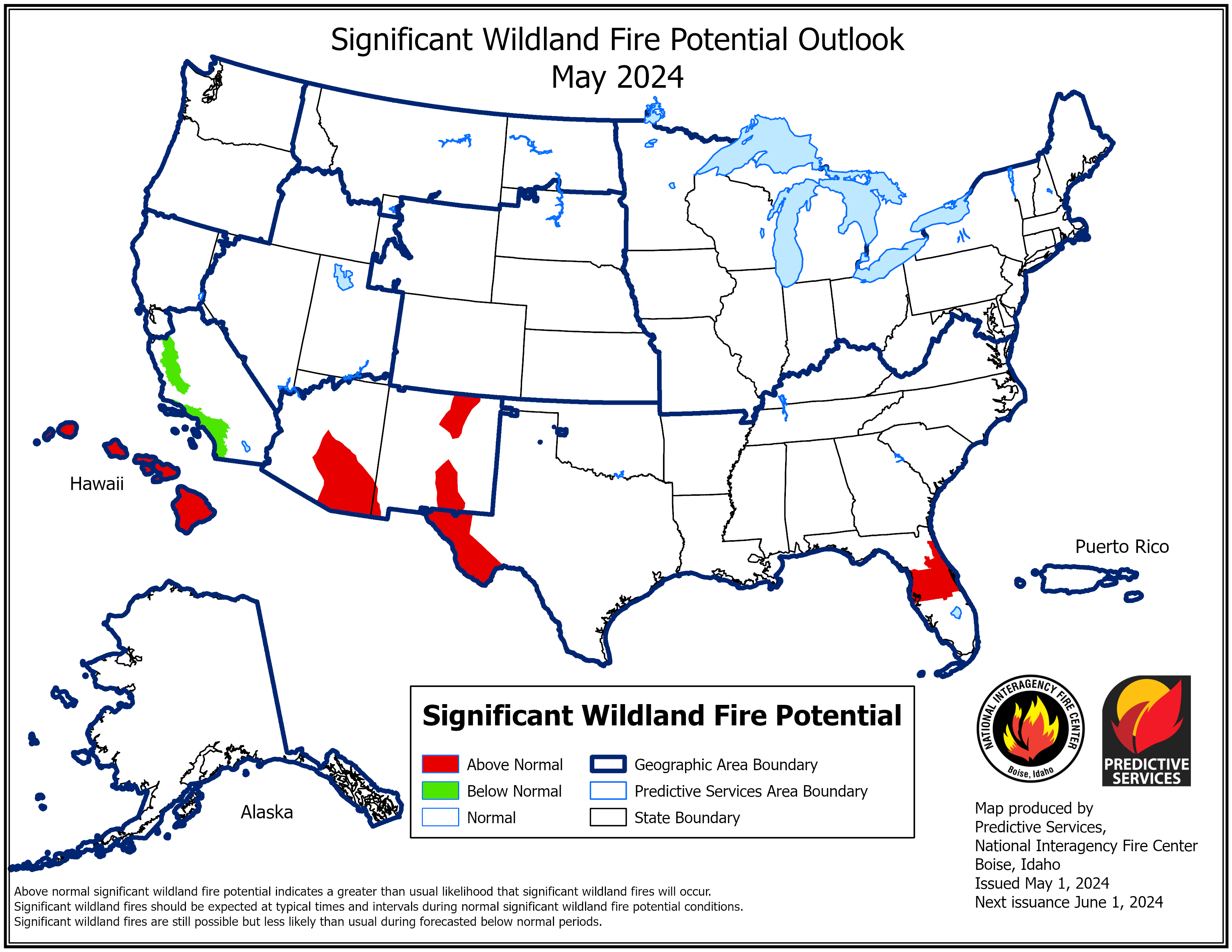
- According to the One-Month Outlook issued on May 1 from the National Interagency Fire Center, Hawaii and portions of Florida, northern California, central Oregon, the Great Basin, the western Plains and the central and southern Rocky Mountains have above normal significant wildland fire potential during May.
Regional Highlights
These regional summaries were provided by the six Regional Climate Centers and reflect conditions in their respective regions. These six regions differ spatially from the nine climatic regions of the National Centers for Environmental Information.
Northeast Region (Information provided by the Northeast Regional Climate Center)
April was wetter than normal for many areas, with a mid-month storm bringing record-setting snow, heavy rain, and high winds.
- Temperature
The Northeast’s April average temperature of 45.8 degrees F was 0.3 degrees F colder than normal. April average temperatures for the 12 Northeast states ranged from 2.0 degrees F below normal in West Virginia to 1.6 degrees F above normal in Maine, with six states being colder than normal.
- Precipitation
During April, the Northeast received 4.28 inches of precipitation, 114 percent of normal. April precipitation for the 12 Northeast states ranged from 79 percent of normal in Rhode Island to 138 percent of normal in New Jersey, with nine states being wetter than normal. This April ranked as the 12th wettest since 1895 for Vermont and 14th wettest for New York.
- Drought
The U.S. Drought Monitor from April 5 showed 1 percent of the Northeast in severe drought, 3 percent in moderate drought, and 29 percent as abnormally dry. In fact, 10 of the 12 Northeast states had drought or abnormal dryness present at the beginning of the month. Timely precipitation, particularly during the first half of April, helped alleviate some of the dry conditions. Severe drought eased in western Maine, while moderate drought eased in New Jersey, Pennsylvania, and much of Maryland and West Virginia. Abnormal dryness contracted across the region. The U.S. Drought Monitor from April 26 showed 1 percent of the Northeast in moderate drought and 17 percent as abnormally dry.
- Notable Weather
A late-season nor’easter brought record-setting snowfall, heavy rain, and strong wind gusts to the Northeast from April 18 to 19. Portions of central/northern New York and northeastern Pennsylvania saw 12 to 18 inches of snow, with reports of lightning and intense snowfall rates of up to 3 inches per hour in some locations. Binghamton, New York, accumulated 14.6 inches of snow, making it the site’s greatest two-day snowfall for April (old record was 13.6 inches from April 15 to 16, 2007). The site recorded 11.4 inches of snow on April 19, making it the site’s third snowiest April day since recordkeeping began in 1951 and the site’s latest occurrence of a daily snowfall of at least 11 inches. The heavy, wet snow, and in some locations strong winds, brought down trees and wires, blocking roads and knocking out power. Around 300,000 customers lost power in the Northeast, with a majority of those, nearly 200,000, in New York. In fact, almost half of all (New York State Electric and Gas) customers in Broome County, where Binghamton is located, lost power, some for multiple days. Coastal areas from Maryland to Maine primarily saw rain, with the greatest totals ranging from 2 to 4 inches. Coastal flooding inundated some roads along the New Jersey and Maine shorelines, while river and street flooding occurred in parts of southeastern Pennsylvania, northern Delaware, and eastern Maine due to heavy rain.
- For more information, please visit the Northeast Regional Climate Center Home Page.
Midwest Region (Information provided by the Midwest Regional Climate Center)
- Temperature
The average temperature for the Midwest was 44.4 degrees F (6.9 degrees C) for April, which was 4.3 degrees F (2.4 degrees C) below the 1991-2020 normal. Based on preliminary data, the Midwest had the 15th coldest April since 1895. Temperature departures were coldest in the north, although all nine states had below-normal temperatures. The statewide monthly average temperature ranged from 2.8 degrees F (1.6 degrees C) below normal in Kentucky to 6.9 degrees F (3.8 degrees C) below normal in Minnesota. Preliminary rankings indicate Minnesota had the 8th coldest April on record, while Iowa was tied for 9th coldest and Wisconsin had the 13th coldest. A brief warm-up across the lower Midwest on April 23-25 pushed high temperatures over 80 degrees F (26.6 degrees C) and resulted in over 180 daily high maximum and high minimum temperature records broken or tied. This was followed by a blast of unseasonably cold air across the upper Midwest on April 26-28 that resulted in 330 daily low maximum and daily low minimum temperature records broken or tied.
- Precipitation
Average Midwest precipitation for April was 3.83 inches (97 mm), which was 0.16 inches (4 mm) above normal, or 104 percent of normal. Statewide precipitation totals ranged from 0.77 inches (19.6 mm) below normal in Indiana to 1.9 inches (48.3 mm) above normal in Minnesota. Based on preliminary data, Minnesota had the 4th wettest April on record since 1895. Conditions were persistently wet across the Midwest, even in locations with below-normal precipitation. Many stations reported measurable precipitation (greater than or equal to 0.01 inches (0.25 mm)) on 15 or more days during April, ranking among the top ten for the number of precipitation days.
- Drought
Drought conditions improved throughout April, with about 2% of the region in drought and 10% showing abnormal dryness by the month’s end. Drought was confined to western Iowa while isolated pockets of abnormal dryness were reported across the upper Midwest and extreme eastern Kentucky.
- Flooding
Melting snowpack combined with multiple rounds of heavy precipitation in northwest Minnesota contributed to major flooding on the Red River of the North during the last week in April. The river flood stage at Oslo, Minnesota reached a foot short of the record crest. The Minnesota National Guard was deployed to Crookston to assist with sandbagging and flood response.
- Wind
While April tends to be a breezy month across the Midwest, this year was notably windy in the western and central Midwest. An analysis of 21 Iowa weather stations found that 20 had above-average wind speeds for April. Eighteen stations had their greatest number of hours (dating back 25 years) with April average wind speeds exceeding 20 mph, and eight stations had wind speeds sustained over 20 mph for 300 hours (42 percent of the month). Frequent high peak wind gusts were also notable across the region. Minneapolis, Minnesota reported 22 days with gusts over 35 mph, the most since 1973 by 8 days. St. Louis, Missouri had 15 days with gusts over 35 mph, the most since records started in 1973. Chicago and Indianapolis both had peak wind gusts above 35 mph on about half the days in April.
- Notable Weather Events
A potent storm system brought severe weather to the Midwest on April 12 and 13. On April 12, ten confirmed tornadoes affected Iowa and Minnesota, including three rated EF-2, resulting in injuries and damage to property, trees, and powerlines. Eight weak tornadoes were confirmed on April 13 in Kentucky that caused downed trees and powerlines along with damage to buildings.
- For further details on the weather and climate events in the Midwest, see the weekly and monthly reports at the Midwest Climate Watch page.
Southeast Region (Information provided by the Southeast Regional Climate Center)
- Temperature
Temperatures were near average across much of the Southeast region for the month of April. Monthly mean temperatures were within 2 degrees F (1.1 degrees C) of average for over 87 percent of the 223 long-term (i.e., period of record equaling or exceeding 50 years) stations across the region. There were at least six stations that observed monthly mean temperatures that were ranked within their five warmest or coldest values on record, including Tampa, FL (1890-2022; 3rd warmest) and Opelika, AL (1962-2022; 1st coldest). Maximum temperatures ranged from 3.3 degrees F (1.8 degrees C) above normal in Fort Myers, FL (1902-2022) to 2.6 degrees F (1.4 degrees C) below normal in Huntsville, AL (1894-2022). Daily temperature minimums ranged from 4.6 degrees F (2.6 degrees C) above normal in Melbourne, FL (1942-2022) to 4.1 degrees F (2.3 degrees C) below normal in Augusta, GA (1873-2022). The warmest weather of the month occurred from the 24th through the 26th, as the circulation around the Bermuda High, situated off the Atlantic coast, transported warm, humid air over much of the Southeast region. Daily maximum temperatures exceeded 90 degrees F (32.2 degrees C) across portions of every state, and much of the region observed mean temperatures more than 10 degrees F (5.6 degrees C) above normal. Indeed, Richmond, VA (1871-2022) had a daily maximum temperature of 90 degrees F (32.2 degrees C) on the 24th, and Fort Myers, FL (1902-2022) had a daily maximum temperature of 94 degrees F (34.4 degrees C) on the 26th. In contrast, the coldest weather of the month across the Southeast occurred on the 9th through the 11th, as the circulation around a departing mid-latitude cyclone ushered in cooler air from Canada. Daily minimum temperatures fell below 32 degrees F (0 degrees C) across portions of every state north of Florida.
- Precipitation
Precipitation was variable across much the Southeast region for April, with only a few wet and dry extremes reported. The driest locations were found across southern Florida, southern Georgia, eastern North Carolina, and Virginia. Monthly precipitation totals ranged from 70 to less than 25 percent of normal across these locations. Savannah, GA (1871-2022) only observed 0.87 inches (22 mm) of precipitation, more than 2.5 inches (64 mm) below normal. In contrast, the wettest locations for the month were located across Alabama, central Florida, central Georgia and South Carolina. Precipitation totals ranged from 100 to 200 percent of normal. Tampa, FL (1890-2022; 4th wettest) measured 6.76 inches (172 mm) of precipitation for the month, over 4 inches (102 mm) above normal. On the 6th, a line of thunderstorms produced heavy rainfall across Georgia, with 24-hour precipitation totals exceeding 4 inches (102 mm). Macon, GA (1892-2022) reported 4.16 inches (106 mm) of rainfall making this its 3rd wettest April day on record. The local sheriff’s office in nearby Lamar County, GA, reported that several dirt roads were washed out as a result of the storms. Measurable snowfall was confined to the mountains of western North Carolina and Virginia. The COOP station in Beech Mountain, NC observed 11.1 inches (282 mm) of snowfall, the highest in the region for the month.
- Drought
Drought conditions changed very little across the Southeast region for April. Abnormally dry conditions (D0) with pockets of moderate drought (D1) were observed across northern Virginia. A pocket of severe drought (D2) is in eastern North Carolina coast ringed by moderate drought (D1) and abnormally dry conditions (D0). Moderate drought (D1) ringed by abnormally dry conditions stretch from eastern South Carolina down into southern Georgia. In southern Florida, there were pockets of severe drought (D2), ringed by moderate drought (D1) and abnormally dry conditions (D0). Drought conditions remained the same across Puerto Rico for the month as well, with pockets of moderate drought (D1) ringed by an area of abnormally dry conditions (D0) in the southern part of the Island and pockets of moderate drought (D1) to severe drought (D2) across the Virgin Islands.
- Agriculture
Due to the severe and moderate drought located in the citrus growing region of Florida, farmers had to run irrigation in all areas. The warm and dry conditions allowed for favorable planting conditions in the Panhandle. Moderate drought conditions in southern Georgia required farmers to run irrigation in fields. Cotton planting continued but was slowed due to a lack of soil moisture in some areas. Some low-lying fields were still too wet to plant in central Alabama. However, cattle and pastures remained in good conditions throughout the state. Warm conditions with sporadic rainfall across much of South Carolina resulted in favorable planting conditions, although drought stress is anticipated if the dry conditions continue.
- Severe Weather and Other Impacts
There were 458 reports of severe weather across the Southeast during March, which is 185 percent of the median monthly frequency of 248 reports during 2000-2019. There were 69 confirmed tornadoes reported for the month (23 EF-0, 35 EF-1, 5 EF-2, 3 EF-3, 1 EF-4, and 2 EF-U), 230 percent of the monthly average of 30. Sixty-two of these tornadoes occurred during a severe weather outbreak April 5-6th. The strongest tornado was in Bryan County, GA and was rated EF-4, with winds of 185 mph (83 m/s) on April 5th. This violent tornado extensively damaged and destroyed many homes, structures, and trees. Unfortunately, there was one fatality and twelve injuries. An EF-3 tornado in Houston County, GA, with winds of 160 mph (72 m/s) also occurred on April 5th. As this tornado went across an open field, it snapped a large concrete power pole and destroyed two large high-tension power transmission towers. Fortunately, only one injury was reported. There were 91 reports of hail for the month, with the largest being baseball sized (2.75 inches) in Horry County, SC on April 7th. There were 276 wind reports for the month, which is 189 percent of the average (146 reports). Straight line winds of 80 mph (36 m/s) were observed in Augusta, VA on the 26th, blowing a steeple off a church roof and downing multiple trees. Unfortunately, there were 2 rip current fatalities for the month: one in Alabama and one in Florida.
- For more information, please visit the Southeast Regional Climate Center Home Page.
High Plains Region (Information provided by the High Plains Regional Climate Center)
April was the ‘tale of two cities’ in the High Plains. Grand Forks, North Dakota was among the wettest and coldest on record, while Colorado Springs, Colorado was among the warmest and driest on record. The northern states experienced well below normal temperatures and multiple blizzards, while the southern states remained dry and dealt with wildfires.
Several blizzards tracked through North Dakota during the month, including the historic blizzard from April 12th to 14th. The heavy snowfall combined with gusts up to 60 mph led to drifts up to 8 feet tall. Among the highest snowfall amounts was a report of 36.0 inches outside of Minot. The highest verified amount was 29.5 inches outside Dunn Center. With such high winds, it is hard to accurately measure snowfall. Another blizzard struck the same areas late in the month, with snowfall up to 18.0 inches.
Wildfires were an issue in the southern portion of the region, particularly in Nebraska. Two large fires broke out during the month, which led to two deaths and several towns to be evacuated. The first fire broke out near Arapahoe, with nearly 35,000 acres burned over several days. Later in the month, another fire broke out nearby which burned over 44,000 acres. Several other fires occurred in Colorado during the month, particularly in areas that were extremely dry this month.
Another interesting impact of the ongoing drought was the reduction of hunting permits available for pronghorn and mule deer in Wyoming. Due to the dryness, food sources of these animals are impacted. As a result, permits were reduced to conserve populations this year. Animal populations were already low from the previous year, with the mule deer population only 61 percent of the statewide goal.
- Temperature
Cooler temperatures were present throughout much of the region this month, with well below normal temperatures in the northern states. Multiple locations in the north ranked among the coldest months on record.
In addition to the heavy snowfall across North Dakota, temperatures were also well below normal for the state. Grand Forks ranked 2nd coldest month on record, with an average temperature of 31.8 degrees F which is below freezing. Dickinson, North Dakota, and Sisseton, South Dakota also both recorded their 3rd coldest April on record. A number of locations in North Dakota, South Dakota, and Wyoming observed a top 10 coldest months on record.
Opposite of the cooler temperatures to the north, the southern part of the region experienced above-normal temperatures. Temperatures skyrocketed on the 22nd and 23rd, with areas in Colorado, Kansas, and Nebraska exceeding 90 degrees F. The highest temperature of 101 degrees F was recorded southwest of North Platte, Nebraska on April 23rd. High winds were once again present during these two days, which led to fire issues. The Strom Prediction Center issued several extremely critical fire days during the month during these hot and windy periods.
- Precipitation
Precipitation for the High Plains in March was sharply divided. The northern part of the region was above to well above-normal, while the southern parts were below-normal. Several locations in North Dakota were among the wettest on record, in contrast to multiple places in the southern portions ranking among the driest. The above-normal precipitation in North Dakota helped improve drought conditions, while the dryness in the south only exacerbated drought conditions.
Several blizzards in North Dakota led both Fargo and Grand Forks to rank as their second wettest April on record. Both locations observed over 5 inches of precipitation for the month. Bismarck recorded their snowiest April on record with 21.9 inches of snow falling while also ranking 10th wettest. Along the front range of the Rockies, conditions were dry. In Colorado, Akron and Colorado Springs both observed their driest month on record with minimal precipitation falling. Several locations with eastern Wyoming, western Kansas, and western Nebraska also ranked among the driest Aprils on record.
It was an active month for severe weather across the region, with multiple days of severe weather. Most notably on the 29th, several storms impacted Kansas and Nebraska. Both Kansas and Nebraska reported 4-inch hailstones, while an impressive 91 mph wind gust was recorded outside Davenport, Nebraska. On the same day, a high-end EF-3 tornado tracked through Andover, Kansas causing significant damage and leading to 3 injuries.
- Drought
Dryness continues in the southern parts of the region, while the northern parts received normal to above-normal precipitation. Drought conditions improved significantly in North Dakota and parts of South Dakota after the recent snowstorms, while Kansas and Nebraska remained dry.
The dryness across the western parts of both Nebraska and Kansas led to widespread expansion of extreme drought (D3). Nearly 20 percent of both states are in D3 at the end of April. Some precipitation fell in the drought-stricken areas towards the end of the month, which should improve conditions. Severe drought (D2) also greatly expanded across eastern Colorado towards the end of the month, with many areas receiving well below 25 percent of their normal precipitation. Contrary to the dryness, the northern parts of the region have observed above-normal precipitation. Drought conditions improved one to two classes across the western Dakotas and northern Wyoming. Elsewhere in the region, other improvements and degradation were observed.
- For more information, please visit the High Plains Regional Climate Center Home Page.
Southern Region (Information provided by the Southern Regional Climate Center)
Temperatures on April 6 in South Texas tied for the earliest date ever of 110 F or greater in the United States.
- Temperature
In the Southern Region, temperatures were relatively warm toward the west and cool toward the east. Arkansas and Tennessee both experienced below normal temperatures, with Arkansas 1.3 F cooler than normal and Tennessee 1.9 F cooler than normal. Conversely, Texas recorded its 14th warmest April on record, averaging 68.4 F, or 2.9 F warmer than normal. Louisiana ranked 38th warmest on record, Oklahoma 50th warmest, and Mississippi 55th warmest out of 128 years. Overall, the Southern Region's April was 30th warmest on record, 1.3 F warmer than normal. The hottest temperature of the month was 111 F at a RAWS station in the Santa Ana National Wildlife Refuge in South Texas on April 6. That same day, another RAWS at Falcon Lake in South Texas reached 110 F. These tie for the earliest readings of 110 F or greater in the United States, equaling April 6, 1989, when a few stations in Southern California reached or exceeded the 110 F mark. The coldest temperatures were in Tennessee: the coldest mountain station was Mt Leconte, which reached 14F on multiple occasions, and the coldest lowland station was at Clarksville, which reached 18F on April 19. In Louisiana, the only two readings below freezing were at Homer and Caney on April 9, at 31 F. Mississippi only had four stations below freezing, led by Canton at 28 F.
- Precipitation
Like temperature, precipitation was relatively high toward the east and relatively low toward the west. Arkansas had its 26th wettest April on record, averaging 6.48 inches, which is 1.04 inches above normal. Mississippi ranked 46th wettest, and Tennessee, though 62nd wettest, was 0.58 inches below the 1991-2020 normal. Texas ranked 21st driest, with slightly more than half its normal rainfall, Oklahoma ranked 32nd driest, and Louisiana 48th driest. Overall, the region was 46th driest out of 128 years. Five stations in Arkansas and three in Mississippi recorded over 10 inches for the month, led by Big Fork, Arkansas, at 11.83 inches. Out west, 46 Texas stations recorded zero precipitation and 16 more recorded but a trace. Only four out of 27 stations in Texas's Trans Pecos climate division reported measurable precipitation. The largest single-day rainfall total in the region was 4.87 inches in Sherman, Texas.
- Drought/Flooding
Where drought conditions were mild, drought improved, but the worst drought got worse. On April 26, about 56% of the region was in drought, a drop of 12% from last month, and severe drought also declined from 52% to 46%. However, the proportion in at least extreme drought (D3) increased from 29% to 32% and the proportion in exceptional drought (D4) increased from 5% to 11%. Tennessee was drought-free, while Arkansas and Mississippi had 6% and 4% drought coverage, respectively. About 14% of Louisiana, 39% of Oklahoma, and 50% of Texas were in extreme or exceptional drought. The dry conditions made the establishment of a warm-season crop challenging or impossible in many of the affected areas, and winter wheat remained mostly in very poor condition. The wildfire risk remained high in western Texas and Oklahoma, but the typical reduction of wind speeds from April’s peak was expected to reduce the likelihood of large wildfires.
- Notable Weather Events
There were 61 confirmed tornadoes in the Southern Region in April. Over half of them (31) were in Mississippi; of the remainder, Texas, Arkansas, and Louisiana each had eight tornadoes, and the other six were in Oklahoma. There were no fatalities from tornadoes, but an EF-3 tornado near Salado, Texas on April 12 injured 23 persons, and EF-2 tornadoes in Texas on April 5 and in Mississippi on April 17 each injured one person. Four other tornadoes, all in Mississippi, were rated EF-2. There were 256 hail reports, including a hailstone that fell near Salado, Texas on April 13 that had a diameter of 5.6 inches and a weight of 0.9 points. Separate hailstorms in Arkansas produced an estimated 4.5 inch diameter hailstone in New Blaine on April 12 and a 4.25 inch diameter hailstone in Cherokee Village on April 16. There were 397 severe wind reports, with over 100 in Mississippi alone and only Oklahoma with fewer than fifty reports. Two fatalities were reported in Arkansas, one on April 5 near Minden in a wind-related traffic accident and one on April 13 in Rison when a tree fell on a mobile home. Also of note were widespread straight line winds of 75-85 mph in Van Zandt County, Texas on April 5.
- For more information, please visit the Southern Regional Climate Center Home Page.
Western Region (Information provided by the Western Region Climate Center)
Throughout the northern tier of the West, April brought a welcome return of the Pacific stormtrack and active weather that positively contributed to snowpack and water resources with colder-than-normal temperatures. With 5.61 inches of precipitation, 2.8 inches above normal, Portland, OR observed its wettest April in 82 years of record keeping. Norris Montana observed 3.42 inches of precipitation, 1.1 inches above normal, for its 8th wettest April in 115 years of observations. Since records began in 1969, South Lake Tahoe, CA experienced its 7th wettest April, measuring 1.65 inches of precipitation and 0.4 inch above normal. Unfortunately, the active weather quickly ceased to the south, roughly along the 42°N parallel leading to drier-than-normal and hotter-than-normal conditions drove worsening drought in the southern tier of the West and promoted extreme wildfire growth and behavior in Arizona and New Mexico. Numerous stations in southeastern California, southern Nevada, southern Utah, and throughout Arizona and New Mexico observed their driest April on record. Many stations recorded no precipitation for the month, including Las Vegas, NV (0.2 inch below average, 86 years of records), Bishop, CA (0.2 inch below average, 78 years of records), Phoenix, AZ (0.2 inch below average, 127 years of records), and Albuquerque, NM (0.5 inch below average, 131 years of records).
- Temperature
In alignment with the active spring stormtrack bringing cool and moist airmasses through the region, temperature anomalies during April were 2–8 degrees colder than normal across the northern tier of the West. Many interior locations experienced a top five coldest April. For example, with 87 years of observations, Bonners Ferry, ID observed its coldest April on record with a mean temperature of 40.9 degrees, 7 degrees below average. Big Timber, MT observed a mean temperature of 38.2 degrees, 7 degrees below average and its coldest April in 111 years of record keeping. Similar to the aforementioned latitudinal precipitation gradient, hotter temperature anomalies on the order 2–4 degrees above average were observed in the southern tier of the West. With a mean monthly temperature of 66.7 degrees or 3 degrees above average, Roswell, NM observed its third hottest April since records started in 1893. Curiously, Santa Barbara, CA, with 124 years of records, also experienced its third-warmest April with a mean temperature of 64.2 degrees, which is 3 degrees above average.
- State of the Snowpack and Drought
April precipitation improved widespread snow drought conditions throughout the northern Western U.S. mountains, but with an important caveat (see notable events). At the beginning of the month, when the state of the snowpack informs many important water resources decisions, snowpack was at or below average throughout much of the West, with conditions closer to normal in the Washington Cascades, Northern Rockies, and Colorado Rockies. The Oregon Cascades, Sierra Nevada of California, Basin and Ranges of Nevada and Utah, and ranges in the Snake River Watershed were all well-below normal. However, by the end of April, many regions in the northern tier, such as the Cascades and Northern Rockies, as well as the Sierra Nevada, gained 5-10 inches of liquid, providing a welcome late-season boost to snowpacks that had begun to melt ahead of schedule following a generally warm, dry, and sunny winter and early spring. Despite these gains, as of this writing, approximately 95% of the western U.S. is in drought, with nearly a third (31%) experiencing extreme to exceptional drought.
- April in Hawaii
Sea surface temperatures (SST) north of the Hawaiian Islands are approximately 0–1 degree above normal. To the north, warming SSTs are emerging (recall ‘the Blob’) with colder SSTs persisting to the southeast of the islands as La Niña conditions develop and equatorial upwelling strengthens. Drought remains on all Hawaiian Islands, however some improvement has occurred throughout the winter with 68% of the Islands in some level of drought compared to 100% at the start of February. With a mean temperature of 78.2 degrees (2 degrees above average), Honolulu, HI experienced its fourth hottest April since records began in 1941. Dry conditions were observed on Maui, with Kahului measuring 0.09 inch of rainfall or 1.23 inches below average, marking its sixth driest April since 1905.
April was largely dry in Alaska, with Fairbanks observing its 10th driest April (0.02 inch of precipitation or 0.32 inch below average) since records began in 1930. Temperatures were warmer than normal in the west and colder than normal in the east. With a mean temperature of 27.8 degrees (5 degrees above average), Nome experienced its eighth warmest April since records began in 1901. The anomalously deep snowpack that accumulated throughout the winter started to melt, producing minor runoff impacts. The annual cycle of river ice breakup commenced near the end of the month. Early snowmelt in southwest Alaska combined with dry conditions to allow pre-greened-up tundra to ignite, leading to Alaska’s largest known April wildfire (approximately 10,000 acres) since monthly estimates began in 1993. Along the Panhandle, Juneau experienced within 0.01 inch of normal precipitation (3.44 inches observed; 3.45 inches average). Bering Sea ice, which was thin to start the month, underwent its second-fastest April decline since the start of the satellite era, with 2004 being the fastest declining April on record.
- Significant Events for April 2022
Major snowpack gains in northern tier of West, but not enough to turn the tide of drought: Despite the 5-10 inches of liquid water gains in snowpack through the month of April, peak snowpack values remained below to well-below average for many locations. This highlights a limitation of the use of percent of average. During spring, when snowpack is melting, relatively small gains (or slowing of melt) can drive percent of average values up to exceed 100% of normal but obscuring the fact that peak snowpack was near, or in many cases, well-below average. April storms did bring locations throughout the northern tier of the West to their water year peak with active weather moderating melt rates and prolonging the winter season via precipitation and by limiting solar radiation and hot temperatures. Nonetheless, expectations of drought conditions remain, especially in the southern tier of the West, but throughout the region, due to below-average peak snowpack.
Active spring wildfires in Arizona and New Mexico: Dry fuels amidst prolonged drought and unfavorable fire weather (hot, dry, and windy) have created conditions conducive for wildfire ignition and spread. Several large fires ignited in both Arizona and New Mexico burning over 200,000 acres and destroying property and prompting evacuations of numerous communities in both states.
- For more information, please go to the Western Regional Climate Center Home Page.