
Okeanos Explorer (EX1104): Mid-Cayman Rise Exploration
Vessel: NOAA Ship Okeanos Explorer; Expedition Dates: August 2 - 18, 2011
Project Principals: Kelley Elliott, NOAA/OAR/OER (Expedition Coordinator); Elizabeth Lobecker, NOAA/OAR/OER (Mapping Lead)
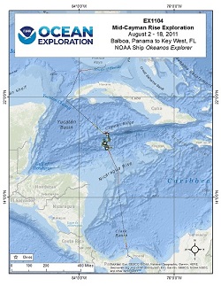
During August 2011, a team of scientists and technicians both at-sea and on shore conducted exploratory interdisciplinary investigations on the geology, marine life, and hydrothermal systems at the Mid-Cayman Rise. The expedition implemented an innovative operating paradigm enabled by telepresence technology using satellites and high bandwidth Internet2 to transmit data and video feeds to shore in real-time. This allowed an international science team working at an Exploration Command Center (ECC) at the University of Rhode Island, and others working from shore-based sites around the world, to collaborate with participants on board and direct daily exploration activities during the cruise. The expedition team systematically explored the region using combined, 24-hour mapping, CTD rosette and ROV operations. Mapping operations focused on the shallow outer "walls" or Oceanic Core Complexes (OCCs) bounding either side of the Mid-Cayman Rise rift valley. The team used a CTD rosette, in situ sensors, and on board gas chromatograph analyses to investigate the water- column overlying the ridge-axis for chemical signals of nearby venting, and conducted detailed ROV observations at the seafloor, including novel vent-sites and the ecosystems they host. The 17-day expedition included 10 days of operations at the Mid-Cayman Rise and one day at the Cayman Trough Fracture Zone, southwest of the Cayman Islands and located entirely within their Exclusive Economic Zone. Over the course of 11 days, nearly 11,000 square kilometers of seafloor were mapped at the Mid-Cayman Rise, primarily focused on the OCCs comprising much of the rift-valley walls, and the Cayman Trough Fracture Zone to the north. 12 ROV dives were conducted: 10 focused on locating and characterizing the full extent of the Von Damm hydrothermal site and exploring further afield on Mount Dent to understand its geologic setting; one dive was conducted on the southeastern rifted OCC; and the final ROV dive conducted a vertical transect up the south-facing slope of the Cayman Trough Fracture Zone.
Expedition Data and Resources
| Ship Navigation Data (ASCII) | Download | Use zip utility to open file |
| Ship SCS/Sensor Data (ASCII) | Download | Use zip utility to open file |
| Ship SCS/Sensor Data (NetCDF) | Open | NetCDF file format: Special software needed to read |
| Shipboard CTDs | Download | Use zip utility to open file |
| Mapping Products | Download | Use zip utility to open file |
| GIS Products | Download | Use zip utility to open file |
Submersible Data and Resources
| Dive Track KMLs | Download | Use zip utility to open file |
| Event Logs | Open | Click to open link |
| Cruise Video Collection Self-Service Portal | Open | Click to open link |
| Submersible Navigation/Sensor Data (ASCII) | Download | Use zip utility to open file |
Educational Resources
| Expedition Education Module | Open | Click to open Education Module |
| Lesson Plans (K-12) | Open | Click to open Lesson Plans |
| Education Materials Collection | Open | Click to open Education Materials |
Links to Archived Data and Resources
| Multibeam Archive Collection | Get Data | Click to Access Archive |
| Physical, Chemical, and Biological Archive Collection | Get Data | Click to Access Archive |
| Collection of Documents | Get Data | Click to Access Archive |
| Expedition Metadata | Open | Click to view Metadata in xml format |
Von Damm
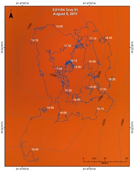
Area
Von Damm; 100 km SSW of Grand Cayman Island
Overview
| Date: | August 5, 2011 |
| Max Depth: | 2343 Meters |
| Bottom Time: | 4 Hours 43 Minutes 46 Seconds |
Purpose
To locate and characterize the full extent of the Von Damm site in a systematic survey covering an area of ~150m on a side. Key objectives will be: To locate the center of the field using the sonars on the vehicles and confirm its precise location relative to the fixes currently provided from our UK colleagues To survey the surrounding area covering as much of the entire field as possible within this first dive to constrain its outer limits To obtain an overview of the geologic features that determine the size/scale of the site To identify biological (or other) "hotspots" by dropping way-points during this dive in anticipation of more detailed studies at each of those locations during one or more subsequent dives later in the program
Download & View Files
| Dive Summary Report (PDF - 301 KB) | View/Download | Requires Adobe Acrobat Reader to view the Dive Summary Report |
| Dive Track (KML - 119 KB) | View/Download | Requires Google Earth or equivalent client to view the Dive Track |
| Dive Trailer (MOV - 59.5 MB) | Download | Link takes you to a public FTP server |
| ROV Ancillary Data (Zip - 68.2 MB) | Download | Link takes you to a public FTP server |
| ROV CTD/Sensor Data (Zip - 2.12 MB) | Download | Link takes you to a public FTP server |
| Camera Platform Sensor Data (Zip - 4.83 MB) | Download | Link takes you to a public FTP server |
| Low-Resolution Video Clips (Zip - 3.4 GB) | Download | Link takes you to a public FTP server |
| Underwater Still Images (Zip - 205 MB) | Download | Link takes you to a public FTP server |
| Dive Video Collection Self-Service Portal | Open | Link takes you to an online video discovery and access tool |
Von Damm
Area
Von Damm; 100 km SSW of Grand Cayman Island
Overview
| Date: | August 6, 2011 |
| Max Depth: | 1192 Meters |
| Bottom Time: | n/a |
Purpose
Little Herc was deployed but at 1000m there appeared to be a problem and Little Herc was recovered to deck for mechanical attention.
Download & View Files
| Dive Summary Report (PDF - 141 KB) | View/Download | Requires Adobe Acrobat Reader to view the Dive Summary Report |
| Dive Trailer (MOV - 44.2 MB) | Download | Link takes you to a public FTP server |
| ROV Ancillary Data (Zip - 46.5 MB) | Download | Link takes you to a public FTP server |
| ROV CTD/Sensor Data (Zip - 770 KB) | Download | Link takes you to a public FTP server |
| Camera Platform Sensor Data (Zip - 1.59 MB) | Download | Link takes you to a public FTP server |
| Low-Resolution Video Clips (Zip - 895 MB) | Download | Link takes you to a public FTP server |
| Underwater Still Images (Zip - 20.7 MB) | Download | Link takes you to a public FTP server |
| Dive Video Collection Self-Service Portal | Open | Link takes you to an online video discovery and access tool |
Von Damm
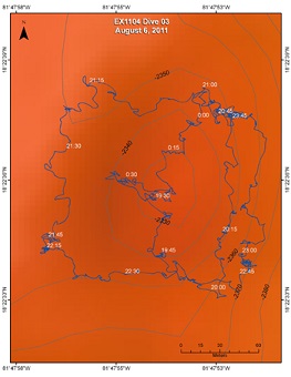
Area
Von Damm; 100 km SSW of Grand Cayman Island
Overview
| Date: | August 6, 2011 |
| Max Depth: | 2372.1 Meters |
| Bottom Time: | 4 Hours 57 Minutes 17 Seconds |
Purpose
The plans for Dive 03 are, if possible, to complete characterization of the Von Damm vent-site and then, as time permits, commence off-site reconnaissance. To that end the dive plan should include: Dive to central pinnacle for navigation orientation and ensure internal consistency from Dive 01 Proceed south to outermost line that has not yet been completed from Dive 01 plan Proceed, counterclockwise around entire site to complete all 4 lines remaining from Dive 01 and ending due south of the Spire If, under (3) there were still hydrothermal systems/communities encountered (particularly to South and East of Spire), add in additional survey lines a further 15m out from those already planned for Dive 01 Once outermost survey lines have been completed, proceed to detailed studies within the Von Damm "box" Head north, to East of Spire, to vestimentiferan sites (to understand their setting and seek for live animals) Study outer "patches" of shrimp on way north, look for suitable sites for flow study (Jill McDermott request) Head to main spire for detailed biological study If time permits, conduct single transect South and East away from Central Spire along SE trending ridge in Connelly et al map Reserve right to modify all the above upon discovery of trilobites (or live T-rex)
Download & View Files
| Dive Summary Report (PDF - 279 KB) | View/Download | Requires Adobe Acrobat Reader to view the Dive Summary Report |
| Dive Track (KML - 138 KB) | View/Download | Requires Google Earth or equivalent client to view the Dive Track |
| Dive Trailer (MOV - 44.2 MB) | Download | Link takes you to a public FTP server |
| ROV Ancillary Data (Zip - 51.7 MB) | Download | Link takes you to a public FTP server |
| ROV CTD/Sensor Data (Zip - 2.28 MB) | Download | Link takes you to a public FTP server |
| Camera Platform Sensor Data (Zip - 5.35 MB) | Download | Link takes you to a public FTP server |
| Low-Resolution Video Clips (Zip - 3.6 GB) | Download | Link takes you to a public FTP server |
| Underwater Still Images (Zip - 148 MB) | Download | Link takes you to a public FTP server |
| Dive Video Collection Self-Service Portal | Open | Link takes you to an online video discovery and access tool |
Von Damm
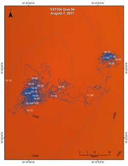
Area
Von Damm; 100 km SSW of Grand Cayman Island
Overview
| Date: | August 7, 2011 |
| Max Depth: | 2339.4 Meters |
| Bottom Time: | 5 Hours 40 Minutes 38 Seconds |
Purpose
The plans for Dive 04 are to conduct detailed biological characterization of hotspot areas identified at the Von Damm site and also aim to include an experiment of opportunity for fluid flow: Start at central spire for orientation Drive East toward markers 19 and 20 to study live tube worm site Aim to region of UK marker (bucket lid) to study patches of shrimp there and assess feasibility of fluid flow experiment (Jill McDermott request) Head to main spire for detailed biological study If time permits, conduct single transect South and East away from Central Spire along SE trending ridge in Connelly et al map
Download & View Files
| Dive Summary Report (PDF - 257 KB) | View/Download | Requires Adobe Acrobat Reader to view the Dive Summary Report |
| Dive Track (KML - 142 KB) | View/Download | Requires Google Earth or equivalent client to view the Dive Track |
| Dive Trailer (MOV - 56.8 MB) | Download | Link takes you to a public FTP server |
| ROV Ancillary Data (Zip - 63.7 MB) | Download | Link takes you to a public FTP server |
| ROV CTD/Sensor Data (Zip - 2.59 MB) | Download | Link takes you to a public FTP server |
| Camera Platform Sensor Data (Zip - 6.06 MB) | Download | Link takes you to a public FTP server |
| Low-Resolution Video Clips (Zip - 3.4 GB) | Download | Link takes you to a public FTP server |
| Underwater Still Images (Zip - 150 MB) | Download | Link takes you to a public FTP server |
| Dive Video Collection Self-Service Portal | Open | Link takes you to an online video discovery and access tool |
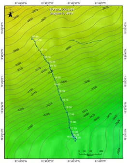
Southern Slopes of Mt. Dent
Area
Southern Slopes of Mt. Dent; 100 km SSW of Grand Cayman Island
Overview
| Date: | August 8, 2011 |
| Max Depth: | 3461.8 Meters |
| Bottom Time: | 4 Hours 39 Minutes 25 Seconds |
Purpose
The plan for Dive 05 is to conduct a Geo-Transect from South to North up the South Flank of Mt Dent, continue uphill from there. Overall plan is to start deep, head uphill all day. Exact distance to be traversed will understandably depend on steepness of terrain encountered at the seafloor. Overview is to proceed as far upslope as possible in a reasonably straight line with ship and Seirios and take advantage of sonar to identify any particularly bright targets along with the freedom of the tether between Little Herc and Seirios to deviate to port and starboard (West and East, across track) as we move uphill to investigate any specific targets encountered. In the event that we only encounter sediment at any locale with no sonar targets nearby we will just proceed uphill as swiftly as possible.
Download & View Files
| Dive Summary Report (PDF - 255 KB) | View/Download | Requires Adobe Acrobat Reader to view the Dive Summary Report |
| Dive Track (KML - 93 KB) | View/Download | Requires Google Earth or equivalent client to view the Dive Track |
| Dive Trailer (MOV - 41.1 MB) | Download | Link takes you to a public FTP server |
| ROV Ancillary Data (Zip - 51 MB) | Download | Link takes you to a public FTP server |
| ROV CTD/Sensor Data (Zip - 2.43 MB) | Download | Link takes you to a public FTP server |
| Camera Platform Sensor Data (Zip - 5.61 MB) | Download | Link takes you to a public FTP server |
| Low-Resolution Video Clips (Zip - 4.8 GB) | Download | Link takes you to a public FTP server |
| Underwater Still Images (Zip - 150 MB) | Download | Link takes you to a public FTP server |
| Dive Video Collection Self-Service Portal | Open | Link takes you to an online video discovery and access tool |
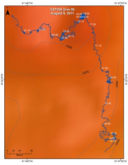
South Slope of the Von Damm Vent Site
Area
South Slope of the Von Damm Vent Site; 100 km SSW of Grand Cayman Island
Overview
| Date: | August 9, 2011 |
| Max Depth: | 2421.9 Meters |
| Bottom Time: | 6 Hours 26 Minutes 2 Seconds |
Purpose
The plan for Dive 06 is to traverse from SSE of Von Damm toward the base of the mound, to conduct a VIP event including broadcasting from the seafloor at the central Von Damm spire and then to continue exploration onward to the West of that vent site as time allows. Specifically: 10:30-12:30 (approx)- We will dive at the launch point which coincides with a locale at which the HYBIS camera system recorded images of worm tubes in Spring 2010, approximately 400m SSE of the central Von Damm spire (Connelly et al., in review). We will then proceed north of there along the spur that extends SE away from the central southern limit of the Von Damm mound and where both high backscatter signals and Eh anomalies in the overlying water column were detected from the AUTOSUB 6000m vehicle during the same cruise (RRS James Cook 44) 12:30-14:00- VIP event preparation and broadcast, central Von Damm spire 14:00-16:00- Continue exploration to West of Von Damm field
Download & View Files
| Dive Summary Report (PDF - 288 KB) | View/Download | Requires Adobe Acrobat Reader to view the Dive Summary Report |
| Dive Track (KML - 144 KB) | View/Download | Requires Google Earth or equivalent client to view the Dive Track |
| Dive Trailer (MOV - 68.7 MB) | Download | Link takes you to a public FTP server |
| ROV Ancillary Data (Zip - 76.2 MB) | Download | Link takes you to a public FTP server |
| ROV CTD/Sensor Data (Zip - 2.7 MB) | Download | Link takes you to a public FTP server |
| Camera Platform Sensor Data (Zip - 6.02 MB) | Download | Link takes you to a public FTP server |
| Low-Resolution Video Clips (Zip - 5 GB) | Download | Link takes you to a public FTP server |
| Underwater Still Images (Zip - 216 MB) | Download | Link takes you to a public FTP server |
| Dive Video Collection Self-Service Portal | Open | Link takes you to an online video discovery and access tool |
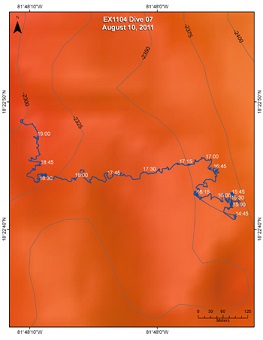
Northwest from Von Damm
Area
Northwest from Von Damm; 100 km SSW of Grand Cayman Island
Overview
| Date: | August 10, 2011 |
| Max Depth: | 2356 Meters |
| Bottom Time: | 7 Hours 35 Minutes 38 Seconds |
Purpose
The aim of the dive was to examine "bright" spots that were found on the backscatter of the bathymetry data from the AUTOSUB during JC44. The ROV was due to visit 16 waypoints numbered 3 to 18.
Download & View Files
| Dive Summary Report (PDF - 238 KB) | View/Download | Requires Adobe Acrobat Reader to view the Dive Summary Report |
| Dive Track (KML - 170 KB) | View/Download | Requires Google Earth or equivalent client to view the Dive Track |
| Dive Trailer (MOV - 55.4 MB) | Download | Link takes you to a public FTP server |
| ROV Ancillary Data (Zip - 62.3 MB) | Download | Link takes you to a public FTP server |
| ROV CTD/Sensor Data (Zip - 2.65 MB) | Download | Link takes you to a public FTP server |
| Camera Platform Sensor Data (Zip - 6.15 MB) | Download | Link takes you to a public FTP server |
| Low-Resolution Video Clips (Zip - 5.9 GB) | Download | Link takes you to a public FTP server |
| Underwater Still Images (Zip - 243 MB) | Download | Link takes you to a public FTP server |
| Dive Video Collection Self-Service Portal | Open | Link takes you to an online video discovery and access tool |
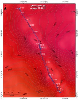
Bumpland
Area
Bumpland; 100 km SSW of Grand Cayman Island
Overview
| Date: | August 11, 2011 |
| Max Depth: | 2202.6 Meters |
| Bottom Time: | 6 Hours 24 Minutes 1 Seconds |
Purpose
The aim of the dive was to determine the rock type within the mounds, test if their orientation is controlled by faulting, and possibly find hydrothermal vents. Observations of the fauna would be made throughout the dive.
Download & View Files
| Dive Summary Report (PDF - 276 KB) | View/Download | Requires Adobe Acrobat Reader to view the Dive Summary Report |
| Dive Track (KML - 143 KB) | View/Download | Requires Google Earth or equivalent client to view the Dive Track |
| Dive Trailer (MOV - 58.3 MB) | Download | Link takes you to a public FTP server |
| ROV Ancillary Data (Zip - 68.6 MB) | Download | Link takes you to a public FTP server |
| ROV CTD/Sensor Data (Zip - 2.38 MB) | Download | Link takes you to a public FTP server |
| Camera Platform Sensor Data (Zip - 5.59 MB) | Download | Link takes you to a public FTP server |
| Low-Resolution Video Clips (Zip - 3.7 GB) | Download | Link takes you to a public FTP server |
| Underwater Still Images (Zip - 211 MB) | Download | Link takes you to a public FTP server |
| Dive Video Collection Self-Service Portal | Open | Link takes you to an online video discovery and access tool |
Europa
Area
Europa; 100 km SSW of Grand Cayman Island
Overview
| Date: | August 12, 2011 |
| Max Depth: | 2298 Meters |
| Bottom Time: | 6 Hours 29 Minutes 50 Seconds |
Purpose
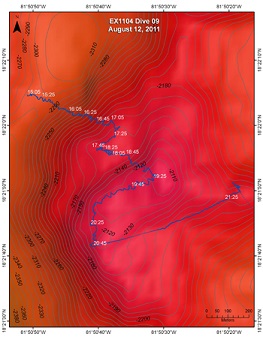
The aim of the dive was to locate the source of pervasive CH4 and Eh anomalies detected in the water column at this site, near the SW limit of Mt Dent's summit, a prioritized area of note from independent analysis of multi-beam bathymetry and backscatter data collected during EX1104. The bathymetry suggested local peaks on a ~2km by 2km slump block. We expected the western edge of the block to be bounded by a N-S trending, high angle normal fault.
Download & View Files
| Dive Summary Report (PDF - 252 KB) | View/Download | Requires Adobe Acrobat Reader to view the Dive Summary Report |
| Dive Track (KML - 154 KB) | View/Download | Requires Google Earth or equivalent client to view the Dive Track |
| Dive Trailer (MOV - 60.9 MB) | Download | Link takes you to a public FTP server |
| ROV Ancillary Data (Zip - 71.6 MB) | Download | Link takes you to a public FTP server |
| ROV CTD/Sensor Data (Zip - 2.35 MB) | Download | Link takes you to a public FTP server |
| Camera Platform Sensor Data (Zip - 5.46 MB) | Download | Link takes you to a public FTP server |
| Low-Resolution Video Clips (Zip - 4.9 GB) | Download | Link takes you to a public FTP server |
| Underwater Still Images (Zip - 247 MB) | Download | Link takes you to a public FTP server |
| Dive Video Collection Self-Service Portal | Open | Link takes you to an online video discovery and access tool |
SE Corner
Area
SE Corner; 100 km SSW of Grand Cayman Island
Overview
| Date: | August 13, 2011 |
| Max Depth: | 3541.6 Meters |
| Bottom Time: | 6 Hours 17 Minutes 23 Seconds |
Purpose
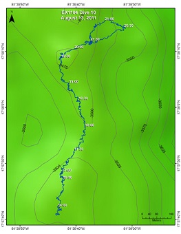
The objective of the dive was to explore the AVR of the Mid-Cayman Rise and look for hydrothermal vents.
Download & View Files
| Dive Summary Report (PDF - 310 KB) | View/Download | Requires Adobe Acrobat Reader to view the Dive Summary Report |
| Dive Track (KML - 96 KB) | View/Download | Requires Google Earth or equivalent client to view the Dive Track |
| Dive Trailer (MOV - 60.6 MB) | Download | Link takes you to a public FTP server |
| ROV Ancillary Data (Zip - 70.9 MB) | Download | Link takes you to a public FTP server |
| ROV CTD/Sensor Data (Zip - 2.68 MB) | Download | Link takes you to a public FTP server |
| Camera Platform Sensor Data (Zip - 6.34 MB) | Download | Link takes you to a public FTP server |
| Low-Resolution Video Clips (Zip - 4.7 GB) | Download | Link takes you to a public FTP server |
| Underwater Still Images (Zip - 197 MB) | Download | Link takes you to a public FTP server |
| Dive Video Collection Self-Service Portal | Open | Link takes you to an online video discovery and access tool |
Mt Doom
Area
Mt Doom; 100 km SSW of Grand Cayman Island
Overview
| Date: | August 14, 2011 |
| Max Depth: | 2520.6 Meters |
| Bottom Time: | 6 Hours 41 Minutes 43 Seconds |
Purpose
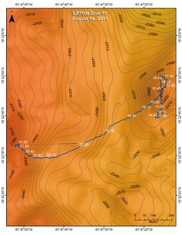
Mt. Doom is similar in shape, but slightly larger than the Von Damm mound and the objective was to explore Mt. Doom to see if it was an abandoned version of Von Damm and then traverse to the west and investigate the slope below Von Damm.
Download & View Files
| Dive Summary Report (PDF - 291 KB) | View/Download | Requires Adobe Acrobat Reader to view the Dive Summary Report |
| Dive Track (KML - 149 KB) | View/Download | Requires Google Earth or equivalent client to view the Dive Track |
| Dive Trailer (MOV - 69.8 MB) | Download | Link takes you to a public FTP server |
| ROV Ancillary Data (Zip - 80.2 MB) | Download | Link takes you to a public FTP server |
| ROV CTD/Sensor Data (Zip - 2.4 MB) | Download | Link takes you to a public FTP server |
| Camera Platform Sensor Data (Zip - 5.8 MB) | Download | Link takes you to a public FTP server |
| Low-Resolution Video Clips (Zip - 5.1 GB) | Download | Link takes you to a public FTP server |
| Underwater Still Images (Zip - 267 MB) | Download | Link takes you to a public FTP server |
| Dive Video Collection Self-Service Portal | Open | Link takes you to an online video discovery and access tool |
Cayman Trough
Area
Cayman Trough; 100 km SSW of Grand Cayman Island
Overview
| Date: | August 15, 2011 |
| Max Depth: | 3267.6 Meters |
| Bottom Time: | 5 Hours 32 Minutes 51 Seconds |
Purpose
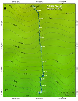
Conduct a geological and biological transect from South to North up the interior (south-facing) wall of the North Cayman Fracture Zone. We know of no similar study in this, or perhaps any other, Fracture Zone even though, along with ridges and trenches, they represent one of the three major types of Plate Tectonic Boundary.
Download & View Files
| Dive Summary Report (PDF - 237 KB) | View/Download | Requires Adobe Acrobat Reader to view the Dive Summary Report |
| Dive Track (KML - 119 KB) | View/Download | Requires Google Earth or equivalent client to view the Dive Track |
| Dive Trailer (MOV - 76.6 MB) | Download | Link takes you to a public FTP server |
| ROV Ancillary Data (Zip - 87.5 MB) | Download | Link takes you to a public FTP server |
| ROV CTD/Sensor Data (Zip - 2.44 MB) | Download | Link takes you to a public FTP server |
| Camera Platform Sensor Data (Zip - 5.54 MB) | Download | Link takes you to a public FTP server |
| Low-Resolution Video Clips (Zip - 2.9 GB) | Download | Link takes you to a public FTP server |
| Underwater Still Images (Zip - 211 MB) | Download | Link takes you to a public FTP server |
| Dive Video Collection Self-Service Portal | Open | Link takes you to an online video discovery and access tool |

