
- 2023 Expeditions
- 2022 Expeditions
- 2021 Expeditions
- 2020 Expeditions
- 2019 Expeditions
- 2018 Expeditions
- 2017 Expeditions
- 2016 Expeditions
- 2015 Expeditions
- 2014 Expeditions
- 2013 Expeditions
- 2012 Expeditions
- 2011 Expeditions
- 2010 Expeditions
|
Okeanos Explorer The following pages provide information about the Okeanos Explorer expeditions conducted, and enables direct access to corresponding data and products. |
|
Okeanos Explorer (EX1001): Shakedown Cruise for Shipboard Systems Integration NOAA ship Okeanos Explorer, "America's Ship for Ocean Exploration," is on a course to be the only U.S. ship assigned to systematically explore our largely unknown ocean for the purpose of discovery and the advancement of knowledge. The ship utilized telepresence to allow shore-based scientists to participate in the expedition. During this 'shakedown cruise' in the vicinity of major islands in the Hawaiian Island chain, the ship ensured all equipment was operational prior to conducting ROV performance testing. |

|
|
Okeanos Explorer (EX1002L1): ROV Integration Period NOAA ship Okeanos Explorer, "America's Ship for Ocean Exploration," is on a course to be the only U.S. ship assigned to systematically explore our largely unknown ocean for the purpose of discovery and the advancement of knowledge. The ship utilized telepresence to allow shore-based scientists to participate in the expedition. During this 'shakedown cruise' in the vicinity of major islands in the Hawaiian Island chain, the ship conducts ROV system and tests. |

|
|
Okeanos Explorer (EX1002L2): ROV Shakedown NOAA ship Okeanos Explorer, "America's Ship for Ocean Exploration," is on a course to be the only U.S. ship assigned to systematically explore our largely unknown ocean for the purpose of discovery and the advancement of knowledge. The ship utilized telepresence to allow shore-based scientists to participate in the expedition. During this 'shakedown cruise' in the vicinity of major islands in the Hawaiian Island chain, the ship conducts ROV system and tests. |

|
|
Okeanos Explorer (EX1002L3): ROV/VSAT Field Trial NOAA ship Okeanos Explorer, "America's Ship for Ocean Exploration," is on a course to be the only U.S. ship assigned to systematically explore our largely unknown ocean for the purpose of discovery and the advancement of knowledge. The ship utilized telepresence to allow shore-based scientists to participate in the expedition. During this 'shakedown cruise' in the vicinity of major islands in the Hawaiian Island chain, the ship conducts ROV system and tests. |

|
|
Okeanos Explorer (EX1003): Transit from Hawaii to Guam NOAA ship Okeanos Explorer, "America's Ship for Ocean Exploration," is on a course to be the only U.S. ship assigned to systematically explore our largely unknown ocean for the purpose of discovery and the advancement of knowledge. The ship utilized telepresence to allow shore-based scientists to participate in the expedition. The ship transits from Hawaii to Guam in anticipation of its maiden voyage, a joint Indonesian-US expedition. |

|
|
Okeanos Explorer (EX1004L1): INDEX - Indonesia-USA Deep-Sea Exploration of the Sangihe Talaud Region: Guam to Bitung Follow the maiden voyage of the NOAA ship Okeanos Explorer, as an international team led by scientists from the United States and Indonesia participated in a collaborative mission to explore the depths of Indonesian waters. The use of telepresence allowed for scientists in the United States to participate remotely. The Indonesia-USA Deep-Sea Exploration of the Sangihe Talaud Region (INDEX-SATAL 2010) expedition kicked off a new era of scientific cooperation between the United States and Indonesia. The joint-expedition also advanced the approach called for by President Obama in his landmark June 2009 speech at Cairo University. This partnership is just one of several initiatives that directly support a recently developed Science and Technology agreement between the two ocean Nations. |

|
|
Okeanos Explorer (EX1004L2): INDEX - Indonesia-USA Deep-Sea Exploration of the Sangihe Talaud Region Follow the maiden voyage of the NOAA ship Okeanos Explorer, as an international team led by scientists from the United States and Indonesia participated in a collaborative mission to explore the depths of Indonesian waters. The use of telepresence allowed for scientists in the United States to participate remotely. The Indonesia-USA Deep-Sea Exploration of the Sangihe Talaud Region (INDEX-SATAL 2010) expedition kicked off a new era of scientific cooperation between the United States and Indonesia. The joint-expedition also advanced the approach called for by President Obama in his landmark June 2009 speech at Cairo University. This partnership is just one of several initiatives that directly support a recently developed Science and Technology agreement between the two ocean Nations. |

|
|
Okeanos Explorer (EX1004L3): INDEX - Indonesia-USA Deep-Sea Exploration of the Sangihe Talaud Region Follow the maiden voyage of the NOAA ship Okeanos Explorer, as an international team led by scientists from the United States and Indonesia participated in a collaborative mission to explore the depths of Indonesian waters. The use of telepresence allowed for scientists in the United States to participate remotely. The Indonesia-USA Deep-Sea Exploration of the Sangihe Talaud Region (INDEX-SATAL 2010) expedition kicked off a new era of scientific cooperation between the United States and Indonesia. The joint-expedition also advanced the approach called for by President Obama in his landmark June 2009 speech at Cairo University. This partnership is just one of several initiatives that directly support a recently developed Science and Technology agreement between the two ocean Nations. |

|
|
Okeanos Explorer (EX1004L4): INDEX - Indonesia-USA Deep-Sea Exploration of the Sangihe Talaud Region: Bitung to Guam Follow the maiden voyage of the NOAA ship Okeanos Explorer, as an international team led by scientists from the United States and Indonesia participated in a collaborative mission to explore the depths of Indonesian waters. The use of telepresence allowed for scientists in the United States to participate remotely. The Indonesia-USA Deep-Sea Exploration of the Sangihe Talaud Region (INDEX-SATAL 2010) expedition kicked off a new era of scientific cooperation between the United States and Indonesia. The joint-expedition also advanced the approach called for by President Obama in his landmark June 2009 speech at Cairo University. This partnership is just one of several initiatives that directly support a recently developed Science and Technology agreement between the two ocean Nations. |

|
|
Okeanos Explorer (EX1005): Transit from Guam to Hawaii NOAA ship Okeanos Explorer, "America's Ship for Ocean Exploration," is on a course to be the only U.S. ship assigned to systematically explore our largely unknown ocean for the purpose of discovery and the advancement of knowledge. The ship utilized telepresence to allow shore-based scientists to participate in the expedition. The ship transits from Guam to Hawaii following the completion of its highly-successful maiden voyage, a joint Indonesian-US expedition. |

|
|
Okeanos Explorer Maximizing Operations (EX1006): Exploring the "sticks" in systematic exploration The expedition objective was to map the bathymetry of the southern flank of the Line Islands in the vicinity of Kingman Reef and Palmyra Atoll, central equatorial Pacific for the U.S. Extended Continental Shelf (ECS) Task Force. The cruise mapped a total of 107,435 km2 in 22 survey days and collected 9942 line km of MBES lines with an average speed of 11.6 kn. |

|
|
Okeanos Explorer (EX1101): Exploring California Seamounts and Archaeological Sites Following a ship shakedown and mapping patch test, the EX conducted high-resolution multibeam mapping and water column exploration with CTD operations on seamounts and archaeological targets identified by the Sanctuary West Coast region and NMFS scientists. Shore-based scientists were able to work simultaneously with the ship via telepresence. |

|
|
Okeanos Explorer (EX1102): ROV Shakedown Cruise This project plan covered the dockside integration of the new OER camera platform into Okeanos Explorer systems and ROV control room, as well as the subsequent shakedown cruise associated with performance and operation of this tandem system using the Institute for Exploration (IFE) Little Hercules ROV as the main vehicle. Shore-based scientists worked simultaneously with the ship via telepresence. |

|
|
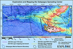
Okeanos Explorer (EX1103L1): Exploration and Mapping, Galapagos Spreading Center: Mapping, CTD, and Tow-yo This cruise was composed of two legs. During the first, the Okeanos Explorer collected multibeam and meteorological/oceanographic (METOC) data during the ~ 15.5 day transit from San Diego to the area of operations in the Galapagos Spreading Center. For the second leg, primary objectives included utilization of the full suite of Okeanos Explorer capabilities (i.e., ROV, mapping, CTD, and telepresence). Daytime operations focused on ROV dives to explore targets identified using bathymetry collected during Leg I and from other ships during previous expeditions. Nighttime operations consisted of vertical CTD casts and multibeam data collection. |

|
|
Okeanos Explorer (EX1103L2): Exploration and Mapping, Galapagos Spreading Center: ROV, Mapping, and CTD This cruise was composed of two legs. During the first, the Okeanos Explorer collected multibeam and meteorological/oceanographic (METOC) data during the ~ 15.5 day transit from San Diego to the area of operations in the Galapagos Spreading Center. For the second leg, primary objectives included utilization of the full suite of Okeanos Explorer capabilities (i.e., ROV, mapping, CTD, and telepresence). Daytime operations focused on ROV dives to explore targets identified using bathymetry collected during Leg I and from other ships during previous expeditions. Nighttime operations consisted of vertical CTD casts and multibeam data collection. |
|
|
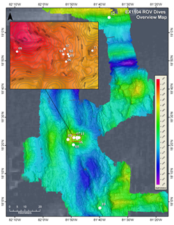
Okeanos Explorer (EX1104): Mid-Cayman Rise Exploration During August 2011, a team of scientists and technicians both at-sea and on shore conducted exploratory interdisciplinary investigations on the geology, marine life, and hydrothermal systems at the Mid-Cayman Rise. The expedition implemented an innovative operating paradigm enabled by telepresence technology using satellites and high bandwidth Internet2 to transmit data and video feeds to shore in real-time. This allowed an international science team working at an Exploration Command Center (ECC) at the University of Rhode Island, and others working from shore-based sites around the world, to collaborate with participants on board and direct daily exploration activities during the cruise. The expedition team systematically explored the region using combined, 24-hour mapping, CTD rosette and ROV operations. Mapping operations focused on the shallow outer "walls" or Oceanic Core Complexes (OCCs) bounding either side of the Mid-Cayman Rise rift valley. The team used a CTD rosette, in situ sensors, and on board gas chromatograph analyses to investigate the water- column overlying the ridge-axis for chemical signals of nearby venting, and conducted detailed ROV observations at the seafloor, including novel vent-sites and the ecosystems they host. The 17-day expedition included 10 days of operations at the Mid-Cayman Rise and one day at the Cayman Trough Fracture Zone, southwest of the Cayman Islands and located entirely within their Exclusive Economic Zone. Over the course of 11 days, nearly 11,000 square kilometers of seafloor were mapped at the Mid-Cayman Rise, primarily focused on the OCCs comprising much of the rift-valley walls, and the Cayman Trough Fracture Zone to the north. 12 ROV dives were conducted: 10 focused on locating and characterizing the full extent of the Von Damm hydrothermal site and exploring further afield on Mount Dent to understand its geologic setting; one dive was conducted on the southeastern rifted OCC; and the final ROV dive conducted a vertical transect up the south-facing slope of the Cayman Trough Fracture Zone. |
|
|
Okeanos Explorer (EX1105): Field Trials of EM302 Multibeam Sonar Water Column Backscatter During this OER project in partnership with NOAA's National Marine Fisheries Service and the Bureau of Ocean Energy Management, two ships will work collaboratively in the Gulf of Mexico to map known targets of man-made or natural seeps to test the use of their sensors to detect these seeps. The NOAA Ship Pisces will utilize its ME70 multibeam sonar sensor and the Okeanos Explorer will use its state-of-the-art Kongsberg EM302 multibeam sonar system and its newly acquired EK60 echosounder. Of special interest to the objectives of this mission is the water column backscatter data component of the EM302 multibeam survey system. These data will be analyzed as they are collected over known natural and man-made seeps in the Gulf of Mexico and, along with the data from the newly acquired EK60 echosounder, will be compared to those data collected by the Pisces ME70 and single beam sonar sensors. |

|
|
Okeanos Explorer (EX1201): Ship Shakedown and Patch Tests The vessel shakedown and sonar patch test was conducted within the context of a ship transit from Davisville, RI to Charleston, SC. During the transit, multibeam data was collected 24 hours a day and XBT casts were conducted at an interval defined by prevailing oceanographic conditions, but at most every 6 hours. Tests of shipboard sensors were conducted and mapping survey patch tests were performed. Shore-based scientists were able to participate alongside those on-board through the use of telepresence. The project is also a contributor to the Atlantic Canyons Undersea Mapping Expedition (ACUMEN) 2012 project. |

|
|
Okeanos Explorer (EX1202L1): Gulf of Mexico Exploration EX1202 Leg I focused on exploration of the North Eastern region of the Gulf of Mexico using the Kongsberg EM302 multibeam sonar, EK 60 and Knudsen sub-bottom profiler. The planned transit line from Charleston, SC to the working grounds was ~ 1000 nautical miles and took about 5 days at an average speed of 8.5 knots. Multibeam mapping operations were conducted 24 hours a day, and included regular XBT casts. Shore-based scientists worked simultaneously with the ship via telepresence. |

|
|
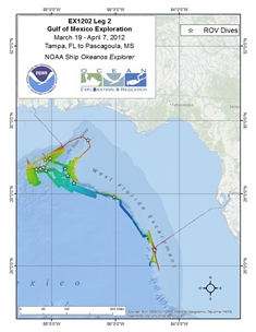
Okeanos Explorer (EX1202L2): Gulf of Mexico Exploration From March through April 2012, a team of scientists and technicians both at-sea and on shore (telepresence) set out to explore cold seeps, deep coral communities, undersea canyons, shipwrecks - and perhaps even mud volcanoes and brine pools. The expedition also marks the return of the Institute for Exploration's Little Hercules remotely operated vehicle (ROV) and NOAA's Seirios camera sled and lighting platform tethered to the NOAA Ship Okeanos Explorer. Primary areas of operations include the vicinity of the Deepwater Horizon site, Mississippi Canyon and Green Canyon and deepwater areas in the vicinity of the Flower Garden Banks. |
|
|
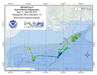
Okeanos Explorer (EX1202L3): Gulf of Mexico Exploration The third leg of the Okeanos Explorer Gulf of Mexico mission operated in a part of the Gulf, the oldest sediments of which are part of the upward-moving Louann Formation. This large deposit of evaporites/salt was deposited about 160 million years ago when the Gulf of Mexico formed, as the continent of South America moved away from North America, a plate separation process known as rifting. Within this rift, seawater rushed in, but was periodically evaporated by the narrowness and complex geography of the rift, leaving vast deposits of salt behind. Over the millions of years since, that salt has been loaded - pushed down and weight added - by many kilometers of younger sediments. Because the salt is less dense than the sediments above it, it begins to rise in fantastic pillars known as diapirs, piercements (because they "pierce" the overlying material), or salt domes. Many of these domes have now reached the seafloor, as can be seen in the figure showing the seafloor off southeastern Louisiana. The Pascagoula and Biloxi domes are two examples of these piercement structures. Sometimes the salt itself actually reaches the seafloor, where the salt dissolves, occasionally filling lows in the seafloor with super-saturated, very dense salty waters known as brines. The architecture of these rising salt-cored domes is complicated; they deform the sediments above them. This complexity is one of the main reasons the Gulf of Mexico is the important oil and gas province that it is. The structures produced in the subsurface trap gas and oil against the salt, which itself is impermeable, so those hydrocarbon fluids pond against the sides of the salt, where they can be found and extracted. The Gulf of Mexico is not the only "salt province" in the world's oceans. Other major provinces occur off the east coast of southern South America and the west coast of central Africa. All are major oil and gas provinces. |
|
|
Okeanos Explorer (EX1203): Florida Escarpment and Straits Exploration On Okeanos Explorer mission EX1203, the vessel transited from Galveston, TX to Norfolk, VA. In the Gulf of Mexico, data holidays were filled in and mapping coverages established during EX1105, EX1106, and EX1202 Legs 1, 2, and 3 were expanded. Additionally, EX1203 developed baseline mapping data over Green Canyon, Mississippi Canyon, Desoto Canyon and the West Florida Shelf Deep Reefs. Along the U.S. Atlantic Continental Shelf Break, mapping coverages established during EX1106 and EX1201 were expanded. These data will also benefit the work conducted by the Bureau of Ocean Energy and Management (BOEM) and the NOAA Office of National Marine Sanctuaries (NMS). Focused water column mapping exploration occurred in the vicinity of the Blake Ridge Diapir and Cape Fear Diapir Complex. Bathymetry mapping focused on delineating the 1000 meter isobaths. |

|
|
Okeanos Explorer (EX1205L1): Exploration, Blake Plateau The EX1205 Leg 1 cruise represents a partnership between NOAA Okeanos Explorer Program, National Science Foundation (NSF) and Woods Hole Oceanographic Institution (WHOI) - with each partner bringing different but complementary objectives to the table. The primary focus for the Office of Ocean Exploration and Research (OER) during EX-12-05 Leg 1 is to test the use of an AUV operated from the Okeanos Explorer while the ship is outfitted for "full" exploration mode and to explore what it will take to integrate an AUV into telepresence-enabled exploration. NSF and WHOI objectives for this cruise include a series of engineering trials and experiments of the Sentry AUV capabilities. NSF objectives for this cruise also include survey data collection using the Sentry AUV and Okeanos Explorer systems that will support a follow-on NSF-funded project at Blake Ridge in 2013 with Principal Investigator, Cindy Van Dover. |

|
|
Okeanos Explorer (EX1205L2): Northeast Canyons and Continental Margins Exploration On Okeanos Explorer mission EX1205 Leg 2, the vessel transited from Morehead City, NC to Davisville, RI. Mapping coverages over Northeast canyons and continental shelf break between Beaufort Inlet, NC and Narragansett Bay, RI were established to supplement coverages made during EX1106, EX1201, EX1204 and by NOAA Ships Nancy Foster, Henry B. Bigelow and Ferdinand R. Hassler. The project is also a contributor to the Atlantic Canyons Undersea Mapping Expedition (ACUMEN) 2012 project. |

|
|
Okeanos Explorer (EX1206): Northeast and Mid-Atlantic Canyons Exploration On a final mission of the FY12 field season, Okeanos Explorer mission EX1206 focused on further supplementing Northeast canyon and continental shelf mapping efforts carried out on EX cruises EX1106, EX1201, EX1204, and during 2011-2012 by NOAA ships Nancy Foster, Henry B.Bigelow, and Ferdinand R. Hassler. The mission is also a contributor to the Atlantic Canyons Undersea Mapping Expedition (ACUMEN) 2012 project. |

|
|
Okeanos Explorer (EX1301): Ship Shakedown and Patch Test Exploration, NE Canyons and Seamounts For the first mission of the year, Okeanos Explorer will be primarily focused on the annual ship and system shakedown and multibeam patch test operations. Following these operations, the EX will complete the comprehensive mapping of the Northeast canyons and the adjacent continental shelf carried out by the cruises involved in the Atlantic Canyons Undersea Mapping Expeditions (ACUMEN) 2012 project. |

|
|
Okeanos Explorer (EX1302): Ship Shakedown, Patch Test and Exploration, NE Canyons Between May 13 and May 18, shakedown operations will: ensure all scientific sonars are in good working order after dry dock operations; assess noise reduction modifications to the sub-bottom profiler; update software and install new multibeam acquisition computer; conduct multibeam patch test; and calibrate the EK60. After May 18, the new 6000 meter ROV will be put through rigorous engineering tests, calibrated, and exercised. Video acquisition procedures and pathways will be tested on the new system, both in terms of broadcast quality video clips as well as testing the new system to record the outgoing video streams. Ship personnel will be trained on video acquisition and image generation protocols. |

|
|
Okeanos Explorer (EX1303): New England Seamount Chain Exploration Transit mapping operations will collect bathymetric, water column backscatter, seafloor backscatter data, and sub-bottom profile data. |

|
|
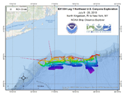
Okeanos Explorer (EX1304L1): Northeast U.S. Canyons Exploration The purpose of Leg 1 of EX1304: Northeast U.S. Canyons Expedition is to employ the new 6,000 meter ROV, Deep Discoverer, and the camera towsled Seirios to explore targeted areas in the Northeast U.S. deepwater canyons. This mission complements the work done through the 2012 Atlantic Canyons Undersea Mapping Expeditions (ACUMEN). |
|
|
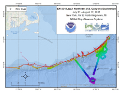
Okeanos Explorer (EX1304L2): Northeast U.S. Canyons Exploration From July 31 to August 16, the Northeast U.S. Canyons 2013 Expedition continued exploration of the geomorphology and benthic ecology of deep-sea canyons and Mytilus Seamount along the Northeast US Atlantic margin. During Leg 2 of this mission, ROV Deep Discoverer (D2) surveyed the area extending between Alvin and Block canyons in the west and Heezen Canyon (eastern limit of the EEZ) to the east. Fifteen dives, ranging in depth from 490 to 3300 m were completed at five named canyons (Nygren, Heezen, Oceanographer, Lydonia, and Welker), one minor canyon (unnamed near Shallop Canyon), two intercanyon sites, two USGS geohazards targets, and Mytilus Seamount. |
|
|
Okeanos Explorer (EX1305): Summer Ecosystem Monitoring Survey The Okeanos Explorer was utilized by the Ecosystem Process Division of the Northeast Fisheries Science Center (NEFSC) to address research goals including: assessing changing biological and physical conditions of living marine resources of the northeast continental shelf ecosystem using CTDs and bongo nets; determining trends in ocean acidification and nutrient levels; sample collection and other analyses. |

|
|
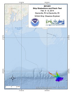
Okeanos Explorer (EX1401): Ship Shakedown and Patch Test To begin the 2014 Okeanos Explorer field season, a ship shakedown and multibeam patch test was performed off the coast of Rhode Island over Veatch Canyon. New mapping survey team members are being trained as well. |
|
|
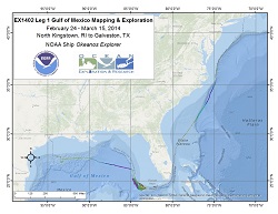
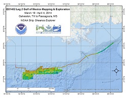
Okeanos Explorer (EX1402L1): Gulf of Mexico Exploration and Mapping Leg 1 of EX1402: Exploration of the Gulf of Mexico mission is a deep water exploratory mapping expedition along a transit path south along the edge of the Atlantic continental shelf south of Rhode Island, to top priority targets in U.S. Federal waters offshore of Florida in both the Atlantic Ocean and the Gulf of Mexico, and to the port of Galveston, Texas. EK60 single beam sonar calibration and testing will be completed. |
|
|
Okeanos Explorer (EX1402L2): Gulf of Mexico Exploration and Mapping Leg 2 of EX1402: Exploration of the Gulf of Mexico mission will be primarily focused on mapping the area to the south and southeast of Flower Garden Banks NMS in the western Gulf of Mexico. Objectives are: 1. Collect deep water multibeam bathymetry sonar data; 2. collect ancillary sonar data (single beam and sub-bottom profile); 3. XBT operations; 4. train new personnel in all data collection and processing procedures; 5. test new or modified mission hardware and software; 6. maintain single live stream video from ship to shore. |
|
|
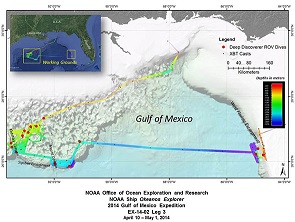
Okeanos Explorer (EX1402L3): Gulf of Mexico Mapping and ROV Exploration Okeanos Explorer cruise EX1402 leg 3 - the final voyage in the series of three ocean exploration cruises as part of the 2014 Gulf of Mexico Expedition - conducted 16 highly successful telepresence-enabled remotely operated vehicle (ROV) dives in two different areas of the Gulf: The northwestern part of the basin, characterized by a very thick (~12-14 kilometer) accumulation of sediments mobilized from below by evaporites/salt, and the central part of the Florida Escarpment, the western edge of a thick carbonate platform, and the outer shelf next to it. Dive 1 was conducted on April 12, and Dive 16 was conducted on April 29. One dive was sacrificed to inclement weather in the first area, and another in the second area could not be conducted because of strong currents and winds. All of these dives were identified by management groups or support management interests in the region. During the course of these dives, our initial count is that more than 230 different types of animals were documented. Northwestern Gulf of Mexico Dives ROV dives were conducted at a diversity of sites. In the northwestern Gulf of Mexico, dives were conducted at two cold seep sites, two deep-sea coral habitat areas of interest for deep-sea coral modeling, three historic shipwrecks (investigated during two dives), three sites in Keathley Canyon, two sites in Bryant Canyon, and two asphalt volcanoes. Highlights of these dives include discovery of asphalt volcanism (nicknamed "tar lilies") in an area of the Gulf where it was not previously known to occur; discovery of a chronometer (a rare and significant finding for an early 19th century vessel) at Monterrey wrecksite A; and possible extension of the depth range of a few deep-sea coral types in the Gulf of Mexico. Several rare observations also occurred, including Paleodictyon "burrows" in Keathley canyon; a rare orange sea star, Dytaster sp., in Bryant Canyon; and a dumbo octopus displaying a body posture that has never before been observed in cirrate octopods. West Florida Escarpment Dives Four ROV dives were also conducted at priority sites on the central part of the West Florida Escarpment, including two dives investigating seafloor habitats in deep water along the escarpment and two dives documenting deep-sea coral habitat in high-priority areas for fisheries management on the shelf. Highlights from these dives included incredible deep-sea coral diversity (at least 23 species) during one of the deep escarpment dives; discovery of two potential new species of crinoids; and close-up imagery documenting a sea urchin eating an octocoral - an observation rarely, if ever, captured on camera. Mission Participation and Reach More than 70 scientists and students participated in these dives from shore, providing their input and expertise to help characterize these areas and guide the exploration. Online coverage of the expedition including live video feeds, were streamed to shore throughout, allowing hundreds of thousands of the public to join our dives and virtually explore the ocean with us! The expedition was highlighted and shared on more than 150 different media venues in the U.S. and Europe, and the live video feeds received more than 700,000 visits during leg 3. Through social media venues and our website's "Ask an Explorer" link, a tremendous number of comments have been shared by the public, expressing excitement about deep ocean observations and thanking the expedition team for allowing them to "dive" with us. |
|
|
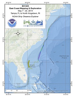
Okeanos Explorer (EX1403): East Coast Mapping and Exploration EX1403 is an exploratory mapping expedition. Using deep water multibeam, single beam and sub-bottom profile data, EX will perform baseline characterization of highest priority areas based on feedback from other NOAA Offices, Programs, Labs and regional management councils. Top priority areas are focused on Marine Protected Areas in the South Atlantic off the east coast of the U.S. EX will also fill data gaps along the Atlantic continental slope. As a survey of opportunity, EX will test an advanced oxygen/argon sensor, to conduct shallow plankton tows to help assess if bluefin tuna are spawning over the Blake Plateau region, and to search for an underwater cultural heritage resource in the vicinity of the continental slope near Cape Hatteras. |
|
|
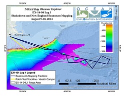
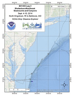
Okeanos Explorer (EX1404L1): Shakedown and Mapping, NE Seamounts The first leg of EX1404 includes various shakedown items that are necessary after the ship has been alongside for the summer, including at-sea testing of the VSAT and communications networks and systems, mapping software updates, hardware upgrades, and sonar calibrations. The transit and the mapping site both are selected to optimize coverage in areas that have been previously unexplored. The working grounds for this leg will extend eastward the existing coverage of the New England Seamount chain. |
|
|
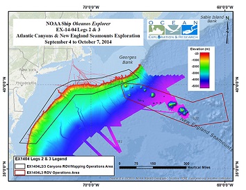
Okeanos Explorer (EX1404L2): ROV Shakedown, VIP Visits, and Northeast Seamounts and Canyons During EX1404 Legs 2 and 3, our team conducted sixteen dives with ROV Deep Discoverer (D2) that explored six seamounts and nine canyons, of which four seamounts and five canyons had never been explored before. We investigated several different habitats at depths ranging from 660 meters to 4692 meters and documented deep-sea corals and their associated invertebrates, a variety of fish and other benthic animals, a diversity of mid-water fauna, and a number of species we have yet to identify. Canyons As was documented in 2013, the submarine canyons investigated during this expedition proved to be biodiversity hotspots, hosting many different species of coral, numerous fish species, several cephalopods (squids and octopus), and a variety of echinoderm species (e.g., sea stars, sea urchins, sea cucumbers). These canyons were generally characterized by downslope areas of soft sediment leading up to steep walls with abundant biological communities under overhangs. Evidence of anthropogenic influence was occasional, with the exception of Ryan and McMaster Canyons where D2 encountered several instances of trash and derelict fishing gear, potentially due to its proximity to shipping channels into large cities on the U.S. East Coast. Highlights from these dives include observations of deep sea predation, a series of caves inhabited by octopuses (dubbed octopus grottoes), dragonfish, and several areas of high coral density. Seamounts During our 6 dives on the New England Seamount Chain, D2 documented extensive deepsea coral and sponge habitat, patchy and often sparse fish distribution, and a variety of exciting geologic features. Seamount dives contained the highest diversity of corals of the expedition, with particularly high densities observed during our dives at Gosnold and Atlantis II. We observed several different types of lava flow, lower sediment cover with a coarser grain size compared to in the canyons, and manganese encrusting over rocks. D2 documented potential range extensions for two species of deepsea coral, previously unknown phenomena in the water column and potential new species, and collected rare imagery of deep-sea predation and behaviors. We also conducted the deepest dive to date on the New England Seamount Chain on an unnamed and previously unexplored seamount that was first mapped in high resolution using Okeanos's EM302 multibeam system in 2013. Highlights from these dives include D2's deepest dive to date, large colonies of precious corals, a dumbo octopus and vampire squid, several rare or unknown species, and areas of active coral recruitment. |
|
|
Okeanos Explorer (EX1404L3): ROV Exploration and Mapping Northeast Seamounts and Canyons During EX1404 Legs 2 and 3, our team conducted sixteen dives with ROV Deep Discoverer (D2) that explored six seamounts and nine canyons, of which four seamounts and five canyons had never been explored before. We investigated several different habitats at depths ranging from 660 meters to 4692 meters and documented deep-sea corals and their associated invertebrates, a variety of fish and other benthic animals, a diversity of mid-water fauna, and a number of species we have yet to identify. Canyons As was documented in 2013, the submarine canyons investigated during this expedition proved to be biodiversity hotspots, hosting many different species of coral, numerous fish species, several cephalopods (squids and octopus), and a variety of echinoderm species (e.g., sea stars, sea urchins, sea cucumbers). These canyons were generally characterized by downslope areas of soft sediment leading up to steep walls with abundant biological communities under overhangs. Evidence of anthropogenic influence was occasional, with the exception of Ryan and McMaster Canyons where D2 encountered several instances of trash and derelict fishing gear, potentially due to its proximity to shipping channels into large cities on the U.S. East Coast. Highlights from these dives include observations of deep sea predation, a series of caves inhabited by octopuses (dubbed octopus grottoes), dragonfish, and several areas of high coral density. Seamounts During our 6 dives on the New England Seamount Chain, D2 documented extensive deepsea coral and sponge habitat, patchy and often sparse fish distribution, and a variety of exciting geologic features. Seamount dives contained the highest diversity of corals of the expedition, with particularly high densities observed during our dives at Gosnold and Atlantis II. We observed several different types of lava flow, lower sediment cover with a coarser grain size compared to in the canyons, and manganese encrusting over rocks. D2 documented potential range extensions for two species of deepsea coral, previously unknown phenomena in the water column and potential new species, and collected rare imagery of deep-sea predation and behaviors. We also conducted the deepest dive to date on the New England Seamount Chain on an unnamed and previously unexplored seamount that was first mapped in high resolution using Okeanos's EM302 multibeam system in 2013. Highlights from these dives include D2's deepest dive to date, large colonies of precious corals, a dumbo octopus and vampire squid, several rare or unknown species, and areas of active coral recruitment. |
|
|
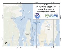
Okeanos Explorer (EX1501): Ship Shakedown and Patch Test EX1501 will be primarily focused on the annual ship and system shakedown and multibeam patch test operations, EK 80 testing and telepresence shakedown items. |
|
|
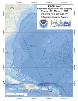
Okeanos Explorer (EX1502L1): Caribbean Exploration and Mapping I EX1502L1 is a transit and mapping cruise from Rhode Island to Puerto Rico. In addition to seafloor mapping by the Okeanos Explorer (EX), three surveys of opportunity will be hosted by the EX during this cruise: NAVOCEANO gliders deployment on shelf break near British Virgin Islands, exploration of the Muertos Trough and the Puerto Rico Trench via untethered free vehicles, and the NASA Maritime Aerosol Network collection of marine aerosol observations using sun photometers. |
|
|
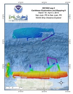
Okeanos Explorer (EX1502L2): Caribbean Exploration and Mapping II EM302 multibeam data will be collected 24 hours a day and will be gathered over previously unexplored regions. Data will be used to better understand the bathymetry of the Puerto Rican trench and allow reconnaissance of the region prior to the ROV cruise. Multibeam operations within 5 miles of land in priority area 1 will be conducted during daylight hours. XBT casts will be conducted at an interval defined by prevailing oceanographic conditions, but not to exceed 6 hours. XBT data will be used to correct the sound velocity of the multibeam data. Additionally, EK 60 (single beam) and sub-bottom profile data will be collected 24 hours per day. |
|
|
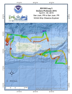
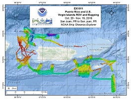
Okeanos Explorer (EX1502L3): Oceano Profundo 2015: Exploring Puerto Rico's Seamounts, Trenches, and Troughs (ROV/Mapping) From April 9-30, 2015, NOAA ship Okeanos Explorer, America's Ship for Ocean Exploration, surveyed unknown deep-sea ecosystems and potential geohazards off the coast of Puerto Rico and the US Virgin Islands. Over 37,500 km square of high-resolution multibeam sonar data was collected, revealing rugged canyons along shelf breaks, intricate incised channels, and large slumps and slope failures. Twelve remotely operated vehicle (ROV) dives, surveyed seamounts, escarpments, and submarine canyons at depths of 300-6,000 m. Additional ROV exploration of the water column occurred at depths of 800-1200 m. Dives included three of the deepest dives ever conducted in the Puerto Rico Trench and the first exploration of Exocet and Whiting seamounts. Discoveries included assemblages of deep-sea corals (>50 species), and observations of several rare and new species. For example, seastar Laetmaster spectabilis had not been documented since its original description in 1881 and a potential new species of benthopelagic ctenophore was observed at 3900 m in the Arecibo Amphitheater. Other expedition highlights included two rarely observed blind octopods (Cirrothauma murrayi); novel observation of a symbiotic association between predatory tunicates with polychaete associates; and approximately 75 species of demersal fishes, including a new species of wrasse and the first records of Shaefer's anglerfish and the ateleopodid jellynose in Puerto Rican waters. ROV dives traversed elements of the complete geological succession from ~1 km deep into the Cretaceous volcanic arc basement, across the carbonate platform sequence unconformity and into the uppermost Pliocene carbonates. Geological highlights included spectacular slope failure headwall scarps and sub-aerial karstic weathering of the youngest carbonates. In addition to the ROV dives, multibeam mapping operations were conducted at night. These efforts enabled mapping of new areas, filling in data holidays and re-mapping areas at higher resolution than what was previously available. |
|
|
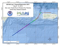
Okeanos Explorer (EX1503L1): Tropical Exploration 2015 (Mapping) After her latest expedition in the Caribbean, Okeanos Explorer left port in San Juan, Puerto Rico and transited to Panama to position itself for its ultimate destination for the remainder of the FY15 field season and the FY16 and FY17 field seasons working in the northwest Hawaiian Islands for the Campaign to Address Pacific Science, Technology, and Ocean NEeds (CAPSTONE) expedition. |
|
|
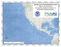
Okeanos Explorer (EX1503L2): Tropical Exploration 2015 (Mapping) On the transit from Panama to Honolulu, the Okeanos Explorer required emergency dry dock for repairs. EX detoured to Bellingham, Washington for these repairs and then completed the transit to Honolulu. |
|
|
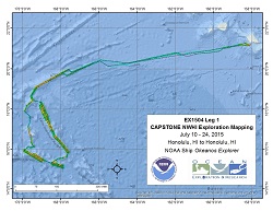
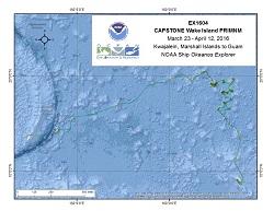
Okeanos Explorer (EX1504L1): CAPSTONE Leg I: Pacific Remote Islands Marine National Monument (PRIMNM) - (Mapping) Multibeam and singlebeam mapping operations will be conducted 24 hours a day throughout the cruise. Sub-bottom profile mapping will be conducted 24 hours a day at the discretion of the CO. Most of the mapping areas to be pursued during this cruise have never been mapped with modern sonar before. Mapping activities will focus on three primary areas, (1) some potential underwater cultural heritage sites south of Oahu, (2) the Necker Island area within the Papahanaumokuakea Marine National Monument (PMNM), and (2) the Karin Seamount Chain near Johnston Atoll within the recently expanded Pacific Remote Islands Marine National Monument (PRIMNM). |
|
|
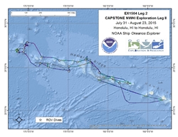
Okeanos Explorer (EX1504L2): Campaign to Address Pacific monument Science, Technology, and Ocean NEeds (CAPSTONE) NWHI Exploration Leg II (ROV/Mapping) The ship will conduct 24 hour operations consisting of daytime ROV dives and evening/nighttime mapping operations including during transit. During this cruise we will conduct 8 hour ROV dives on most days with occasional 10 or 12 hour dives on particularly interesting or deep dive sites. ROV operations will focus in depths between 250 and 6,000 meters and will include high-resolution visual surveys and limited sample collection. Mapping operations will be conducted in 250 m of water and deeper, and include transit and overnight multibeam, water column backscatter, and sub-bottom data collection. Opportunistic CTD rosette operations may be requested to collect more information about the environmental parameters at ROV dives sites, or opportunistically at selected sites where collecting the data is considered important to understanding the physical or chemical properties of the overlying water column. ROV and mapping operations will not be conducted in state waters. CTD rosette operations may be requested in state waters. |
|
|
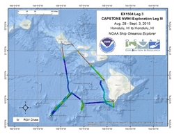
Okeanos Explorer (EX1504L3): CAPSTONE Leg III: Main Hawaiian Islands and Geologists Seamounts (ROV/Mapping) The ship will conduct 24 hour operations consisting of daytime ROV dives and evening/nighttime mapping operations including during transit. During this cruise we will conduct 8 hour ROV dives on most days with occasional 10 or 12 hour dives (at the ship's discretion) on particularly interesting or deep dive sites. ROV operations will focus on depths between 350 and 3,000 meters and will include high-resolution visual surveys and limited sample collection. Mapping operations will be conducted in 250 m of water and deeper, and include overnight multibeam, water column backscatter, and sub-bottom data collection. Opportunistic CTD rosette operations may be requested to collect more information about the environmental parameters at ROV dives sites, or opportunistically at selected sites where collecting the data is considered important to understanding the physical or chemical properties of the overlying water column. |
|
|
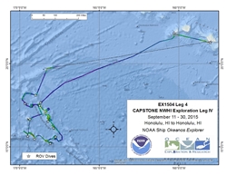
Okeanos Explorer (EX1504L4): Campaign to Address Pacific monument Science, Technology, and Ocean NEeds (CAPSTONE) Leg IV (ROV/Mapping) The ship will conduct 24 hour operations consisting of daytime ROV dives and evening/nighttime mapping operations including during transit. During this cruise we will conduct 8 hour ROV dives on most days with occasional 10 or 12 hour dives on particularly interesting or deep dive sites. ROV operations will focus in depths between 250 and 6,000 meters and will include high-resolution visual surveys and limited sample collection. Mapping operations will be conducted in 250 m of water and deeper, and include transit and overnight multibeam, water column backscatter, and sub-bottom data collection. Opportunistic CTD rosette operations may be requested to collect more information about the environmental parameters at ROV dives sites, or opportunistically at selected sites where collecting the data is considered important to understanding the physical or chemical properties of the overlying water column. ROV and mapping operations will not be conducted in state waters. CTD rosette operations may be requested in state waters. |
|
|
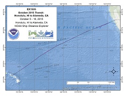
Okeanos Explorer (EX1505): October 2015 Transit: Honolulu, HI to Alameda, CA (Mapping) Throughout this cruise, multibeam data will be collected 24 hours a day and XBT casts will be conducted every 6 hours. Additionally, EK 60 (split beam) and sub-bottom profile data will be collected 24 hours per day, with subbottom profile data collection at the discretion of the CO. Onboard multibeam data processing will be minimal due to limited staffing. Daily or bi-daily multibeam products will be produced according to established shipboard SOP and sent to shore through established shipboard SOP. Onshore mapping physical scientists will monitor data quality, cruise progress, and discovery potential. Raw EK 60 and subbottom data will be sent to the shoreside repository through established shipboard automated archival procedure. |
|
|
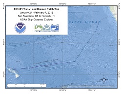
Okeanos Explorer (EX1601): Transit and Mission Patch Test Normal underway operations and mapping patch testing. Bathymetric mapping of either the Murray or Molokai Fracture Zones during the transit to Hawaii is planned, as allowed by equipment shakedown priorities and prevailing sea conditions. CTD casts may be requested at strategic locations along the fracture zone. New equipment in need of shakedown testing includes a new Very Small Aperture Terminal (VSAT) antenna, a new Keyboard-Video-Monitor (KVM) system, new Doppler speed log, four new EK 60 single beam sonars, two new ADCPs, new digital file storage systems, and a newly installed Underway CTD. |
|
|
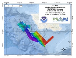
Okeanos Explorer (EX1602): Mission System Shakedown/CAPSTONE Mapping Operations will use the ship's deep water mapping systems (Kongsberg EM302 multibeam sonar, EK60 split-beam fisheries sonars, Knudsen 3260 chirp sub-bottom profiler sonar, Teledyne RDI Workhorse Mariner and Ocean Surveyor ADCPs), NOAA's two-body 6,000 m remotely operated vehicle (ROVs Deep Discoverer and Seirios) system, CTD rosette, and the ship's high-bandwidth satellite connection for real-time ship to shore communications. ROV dives will mostly be conducted during the day, while CTD casts, and multibeam, singlebeam, and sub-bottom acoustic mapping will occur when the ROV is on deck. Exact locations of discrete ROV dives and mapping operations will be determined during the cruise as results of engineering and shakedown tests are evaluated and once weather and operational constraints are factored in. |
|
|
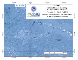
Okeanos Explorer (EX1603): Hohonu Moana: Exploring the Deep Waters off Hawai`i (ROV / Mapping) CAPSTONE The ship will conduct 24 hour operations consisting of daytime ROV dives and evening/nighttime mapping operations including during transit. During this cruise we will conduct primarily 8 hour ROV dives with occasional 10 or 12 hour dives on particularly interesting or deep water dive sites, as staffing allows. ROV operations will focus in depths between 250 and 6,000 meters and will include high-resolution visual surveys and limited sample collection. Mapping operations will be conducted in 250 m of water and deeper, and include transit and overnight multibeam, water column backscatter, and sub-bottom data collection. Opportunistic CTD rosette operations may be requested to collect more information about the environmental parameters at ROV dives sites, or opportunistically at selected sites where collecting the data is considered important to understanding the physical or chemical properties of the overlying water column. ROV and mapping operations will not be conducted in state waters. Dive(s) will also be devoted to searching for ship's lost during the World War II Battle of Midway with an emphasis on finding the main wreck of the Japanese Aircraft Carriers Kaga. Data collected by OER that is considered sensitive will be protected from direct public release until such time as a final determination can be made as to permanent protection. If data are found to be sensitive because they reveal the location of a historically significant cultural resource, Section 304 of the National Historic Preservation Act provides that the head of a Federal agency or other public official shall withhold from public disclosure information about the location, character, or ownership of a historic property when disclosure may cause a significant invasion of privacy; risk harm to the historic property; or impede the use of a traditional religious site by practitioners. Data collected by the EX that is considered sensitive will be archived in a location where it can be withheld from public disclosure. |
|
|
Okeanos Explorer (EX1604): CAPSTONE Wake Island PRIMNM (Preliminary Mapping) Multibeam and singlebeam mapping operations will be conducted 24 hours a day throughout the cruise. Sub-bottom profile mapping will be conducted 24 hours a day at the discretion of the CO. XBT and/or UnderwayCTD (UCTD) sound velocity casts in support of multibeam sonar mapping operations will be conducted at an interval defined by prevailing oceanographic conditions, but not to exceed 6 hours. All data will be fully processed according to standard onboard procedures and will be archived with the NOAA National Centers for Environmental Information. |
|
|
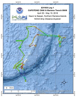
Okeanos Explorer (EX1605L1): CAPSTONE CNMI & Mariana Trench MNM (ROV & Mapping) The ship will conduct 24 hour operations consisting of daytime ROV dives and evening/nighttime mapping operations including during transit. During this cruise we will conduct primarily 8 hour ROV dives with occasional 10 or 12 hour dives on particularly interesting or deep water dive sites, as staffing allows. ROV operations will focus in depths between 250 and 6,000 meters and will include high-resolution visual surveys and limited sample collection. Mapping operations will be conducted in 250 m of water and deeper, and include transit and overnight multibeam, water column backscatter, and sub-bottom data collection. Opportunistic CTD rosette operations may be requested to collect more information about the environmental parameters at ROV dives sites, or opportunistically at selected sites where collecting the data is considered important to understanding the physical or chemical properties of the overlying water column. |
|
|
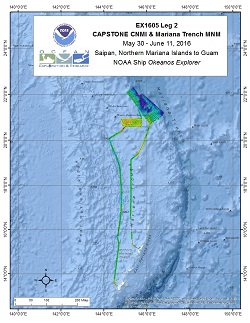
Okeanos Explorer (EX1605L2): CAPSTONE CNMI & Mariana Trench MNM (Mapping) Operations will use the ship's deep water mapping systems (Kongsberg EM302 multibeam sonar, EK60 splitbeam fisheries sonars, ADCPs, and Knudsen 3260 chirp sub-bottom profiler sonar), CTD rosette, and the ship's high-bandwidth satellite connection for periodic real-time ship to shore communications. Operations for this cruise will include 24 hour mapping, periodic telepresence-based remote participation, and CTD rosette operations. Multibeam and singlebeam mapping operations will be conducted 24 hours a day throughout the cruise. Sub-bottom profile mapping will be conducted 24 hours a day at the discretion of the CO. XBT and/or UnderwayCTD (UCTD) sound velocity casts in support of multibeam sonar mapping operations will be conducted at an interval defined by prevailing oceanographic conditions, but not to exceed 6 hours. |
|
|
Okeanos Explorer (EX1605L3): CAPSTONE CNMI & Mariana Trench MNM (ROV & Mapping) The ship will conduct 24 hour operations consisting of daytime ROV dives and evening/nighttime mapping operations including during transit. During this cruise we will conduct primarily 8 hour ROV dives with occasional 10 or 12 hour dives on particularly interesting or deep water dive sites, as staffing allows. ROV operations will focus in depths between 250 and 6,000 meters and will include high-resolution visual surveys and limited sample collection. Mapping operations will be conducted in 250 m of water and deeper, and include transit and overnight multibeam, water column backscatter, and sub-bottom data collection. CTD rosette operations are requested at several sites to inform ROV dives, and may be requested opportunistically at selected sites where collecting the data is considered important to understanding the physical or chemical properties of the overlying water column. |

|
|
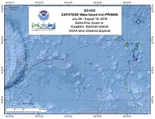
Okeanos Explorer (EX1606): CAPSTONE Wake Island Unit PRIMNM (ROV & Mapping) Operations will use the ship's deep water mapping systems (Kongsberg EM302 multibeam sonar, EK60 split-beam fisheries sonars, ADCPs, and Knudsen 3260 chirp sub-bottom profiler sonar), NOAA's two-body 6000 m remotely operated vehicle (ROVs Deep Discoverer and Seirios), CTD rosette, and the ship's high-bandwidth satellite connection for real-time ship to shore communications. Daytime ROV dives are planned most days from July 28 - August 16th and a few dedicated mapping transit days are also expected. ROV dives will include high-resolution visual surveys and limited rock and biologic specimen sampling. Mapping operations will be conducted overnight and when the ROV is on deck. CTD casts may be requested during the cruise to collect more environmental information at sites of interest. |
|
|
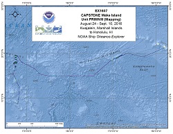
Okeanos Explorer (EX1607): CAPSTONE Wake Island PRI MNM (Mapping) Operations will include 24 hour/day mapping operations using the ship's deep water mapping systems (Kongsberg EM302 multibeam sonar, EK60 split-beam fisheries sonars, ADCPs, and Knudsen 3260 chirp subbottom profiler sonar), CTD rosette, and the ship's high-bandwidth satellite connection for real-time ship to shore communications. Operations for this cruise will include 24 hour mapping, and continuous telepresence based remote participation in mapping operations. Multibeam and singlebeam mapping operations will be conducted 24 hours a day throughout the cruise. Sub-bottom profile mapping will be conducted 24 hours a day at the discretion of the CO. XBT sound velocity casts in support of multibeam sonar mapping operations will be conducted at an interval defined by prevailing oceanographic conditions, but not to exceed 6 hours. |
|
|
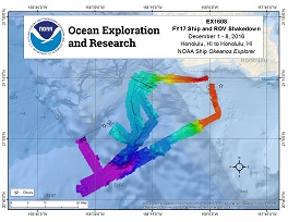
Okeanos Explorer (EX1608): FY17 Ship and ROV Shakedown Operations will use the ship's deep water mapping systems (Kongsberg EM302 multibeam sonar, EK60 splitbeam fisheries sonars, ADCPs, and Knudsen 3260 chirp sub-bottom profiler sonar), NOAA's two-body 6000 m remotely operated vehicles (ROVs Deep Discoverer and Seirios, and the ship's high-bandwidth satellite connection for real-time ship to shore communications. |
|
|
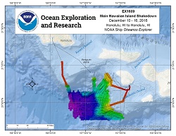
Okeanos Explorer (EX1609): Main Hawaiian Island Shakedown (Mapping) Multibeam, split-beam, and/or ADCP sonar mapping operations will be conducted 24 hours a day throughout the cruise. Sub-bottom profile mapping will be conducted periodically during the cruise for testing purposes and is subject to the discretion of the CO. XBT and/or UnderwayCTD sound velocity casts in support of multibeam sonar mapping operations will be conducted at an interval defined by prevailing oceanographic conditions, but not to exceed 6 hours. Multibeam data will be fully processed according to standard onboard procedures and will be archived with the National Centers for Environmental Information (NCEI). Split-beam EK60 data and ADCP data will be archived in their raw formats with NCEI as well. |
|
|
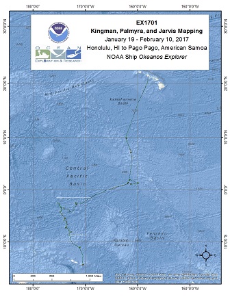
Okeanos Explorer (EX1701): CAPSTONE Kingman/Palmyra, Jarvis (Mapping) Operations will include the use of the ship's deep water mapping systems (Kongsberg EM302 multibeam sonar, EK60 split-beam fisheries sonars, ADCPs, and Knudsen 3260 chirp sub-bottom profiler sonar), and the ship's high-bandwidth satellite connection for real-time ship to shore communications. Focused mapping operations will occur in the Pacific Remote Islands Marine National Monument (PRIMNM)(U.S.) in the vicinity of Kingman Reef and Palmyra Atoll, and Jarvis Island, as well as in the Phoenix Islands Protected Area (PIPA) (Republic of Kiribati). |
|
|
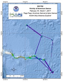
Okeanos Explorer (EX1702): CAPSTONE American Samoa Expedition: Suesuega o le Moana o Amerika Samoa (ROV/Mapping) Operations for this cruise will be conducted 24 hours/day and consist of daily remotely operated vehicle (ROV), overnight mapping, CTD casts and full shore-based participation via telepresence. Operations will be conducted within several marine protected areas. Operations are planned in the Rose Atoll Marine National Monument, National Marine Sanctuary of American Samoa, offshore (not within) of the National Park of American Samoa, and the waters of both American Samoa and Samoa. |
|
|
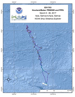
Okeanos Explorer (EX1703): CAPSTONE Howland/Baker PRIMNM and PIPA (ROV/Mapping) Operations for this cruise will be conducted 24 hours/day and consist of daily remotely operated vehicle (ROV), overnight mapping, CTD casts and full shore-based participation via telepresence. Operations will be conducted within several marine protected areas. |
|
|
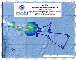
Okeanos Explorer (EX1704): CAPSTONE American Samoa and Cook Islands (Telepresence Mapping) Operations for this cruise will include 24 hour mapping, and continuous telepresence-based remote participation in mapping operations. Multibeam and splitbeam mapping operations will be conducted 24 hours a day throughout the cruise. Sub-bottom profile mapping will be conducted 24 hours a day at the discretion of the CO. XBT and Underway CTD sound velocity casts in support of multibeam sonar mapping operations will be conducted at an interval defined by prevailing oceanographic conditions, but not to exceed 6 hours. All mapping data will be fully processed according to standard procedures and will be archived with the National Centers for Environmental Information (NCEI). |
|
|
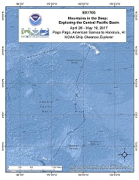
Okeanos Explorer (EX1705): CAPSTONE American Samoa, Kingman/Palmyra, Jarvis (ROV & Mapping) Operations will include the use of the ship's deep water mapping systems (Kongsberg EM302 multibeam sonar, EK60 split-beam fisheries sonars, Knudsen 3260 chirp sub-bottom profiler sonar, and Teledyne Acoustic Doppler Current Profilers), XBT and Underway CTD casts in support of multibeam sonar mapping operations, OER's 6000 m two-body ROV Deep Discoverer and Seirios, and the ship's high-bandwidth satellite connection for continuous real-time ship-to-shore communications. |
|
|
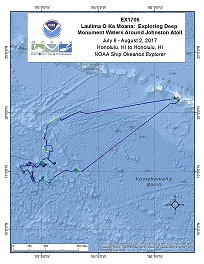
Okeanos Explorer (EX1706): Johnston Atoll (ROV/Mapping) Operations will include the use of the ship's deep water mapping systems (Kongsberg EM302 multibeam sonar, EK60 split-beam fisheries sonars, Knudsen 3260 chirp sub-bottom profiler sonar, and Teledyne Acoustic Doppler Current Profilers), XBT and Underway CTD casts in support of multibeam sonar mapping operations, OER's 6000 m two-body ROV Deep Discoverer and Seirios, and the ship's high-bandwidth satellite connection for continuous real-time ship-to-shore communications. |
|
|
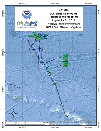
Okeanos Explorer (EX1707): Musicians Seamounts (Telepresence Mapping) Operations for this cruise will include 24 hour mapping, and continuous telepresence-based remote participation in mapping operations. Multibeam and splitbeam mapping operations will be conducted 24 hours a day throughout the cruise. Sub-bottom profile mapping will be conducted 24 hours a day at the discretion of the CO. XBT and Underway CTD sound velocity casts in support of multibeam sonar mapping operations will be conducted at an interval defined by prevailing oceanographic conditions, but not to exceed 6 hours. All mapping data will be fully processed according to standard procedures and will be archived with the National Centers for Environmental Information (NCEI). |
|
|
Okeanos Explorer (EX1708): Musicians Seamounts (ROV & Mapping) Operations for this cruise will be conducted 24 hours/day and consist of daily remotely operated vehicle (ROV), overnight mapping, and full shore-based participation via telepresence. Operations will include the use of the ship's deep water mapping systems (Kongsberg EM302 multibeam sonar, EK60 split-beam fisheries sonars, Knudsen 3260 chirp sub-bottom profiler sonar, and Teledyne Acoustic Doppler Current Profilers), XBT and CTD casts in support of multibeam sonar mapping operations, OER's two-body ROV Deep Discoverer and Seirios, and the ship's high-bandwidth satellite connection for continuous real-time ship-to-shore communications. Operations are planned in and around Hawaii, the US EEZ, and in the High Seas around the Musicians Seamounts. |

|
|
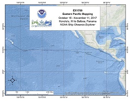
Okeanos Explorer (EX1709): Eastern Pacific Mapping (Telepresence Mapping) Operations for this cruise will include 24 hour mapping, and continuous telepresence-based remote participation in mapping operations. Multibeam and splitbeam mapping operations will be conducted 24 hours a day throughout the cruise, except during CTD operations. Sub-bottom profile mapping will be conducted 24 hours a day at the discretion of the CO. XBT and Underway CTD sound velocity casts in support of multibeam sonar mapping operations will be conducted at an interval defined by prevailing oceanographic conditions, but not to exceed 6 hours. |
|
|
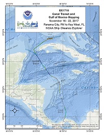
Okeanos Explorer (EX1710): Canal Transit and Gulf of Mexico Mapping (Mapping) Multibeam and splitbeam mapping operations will be conducted 24 hours a day throughout the cruise. Sub-bottom profile mapping will be conducted 24 hours a day at the discretion of the CO. XBT and/or Underway CTD sound velocity casts in support of multibeam sonar mapping operations will be conducted at an interval defined by prevailing oceanographic conditions, but not to exceed 6 hours. All mapping data will be fully processed according to standard procedures and will be archived with the National Centers for Environmental Information (NCEI). |
|
|
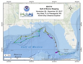
Okeanos Explorer (EX1711): Gulf of Mexico (ROV and Mapping) Operations will include the use of the ship's deep water mapping systems (Kongsberg EM302 multibeam sonar, EK60 split-beam fisheries sonars, Knudsen 3260 chirp sub-bottom profiler sonar, and Teledyne Acoustic Doppler Current Profiler), XBT and CTD casts in support of multibeam sonar mapping operations, OER's two-body ROV Deep Discoverer and Seirios, and the ship's high-bandwidth satellite connection for continuous real-time ship-to-shore communications. |
|
|
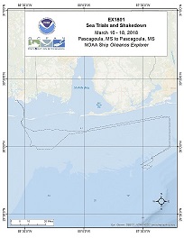
Okeanos Explorer (EX1801): Gulf of Mexico Sea Trials and Shakedown (Mapping) Operations will include the use of the ship's deep water mapping systems (Kongsberg EM302 multibeam sonar, EK60 split-beam fisheries sonars, Knudsen 3260 chirp sub-bottom profiler sonar, and Teledyne Acoustic Doppler Current Profiler), XBT and CTD casts in support of multibeam sonar mapping operations, and the ship's high-bandwidth satellite connection for continuous real-time ship-to-shore communications. |
|
|
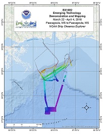
Okeanos Explorer (EX1802): Gulf of Mexico Mapping and Emerging Technology Demonstration (Mapping) Operations will include the use of the ship's deep water mapping systems (Kongsberg EM302 multibeam sonar, EK60 split-beam fisheries sonars, Knudsen 3260 chirp sub-bottom profiler sonar, and Teledyne Acoustic Doppler Current Profiler), and XBT casts in support of multibeam sonar mapping operations, and the ship's high-bandwidth satellite connection for continuous real-time ship-to-shore communications. Operations are planned in the northern Gulf of Mexico. Emerging technologies components of this cruise will be in partnership with the Cooperative Institute for Ocean Exploration Research and Technology (CIOERT) at Florida Atlantic University and the Naval Undersea Warfare Center (NUWC) Newport RI. |
|
|
Okeanos Explorer (EX1803): Gulf of Mexico (ROV and Mapping) Operations will include the use of the ship's deep water mapping systems (Kongsberg EM302 multibeam sonar, EK60 split-beam fisheries sonars, Knudsen 3260 chirp sub-bottom profiler sonar, and Teledyne Acoustic Doppler Current Profiler), XBT and CTD casts in support of multibeam sonar mapping operations, OER's two-body ROV Deep Discoverer and Seirios, and the ship's high-bandwidth satellite connection for continuous real-time ship-to-shore communications. Operations are planned in and around the US Gulf of Mexico and potentially the international waters of the Gulf. |

|
|
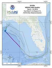
Okeanos Explorer (EX1804): VIIRS (Mapping, Third Party) SE US While this Okeanos Explorer mission will be managed by NESDIS's Visible Infrared Imaging Radiometer Suite (VIIRS) Satellite project, OER will have a mapping lead, Mike White, onboard to perform opportunistic multibeam surveying. OER data management will manage these data in the same manner as other Okeanos missions. |
|
|
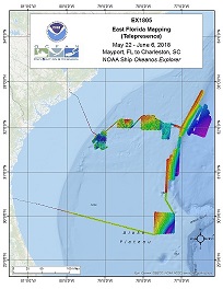
Okeanos Explorer (EX1805): East Florida Telemapping (Mapping) The screens of the mapping acquisition systems (EM 302, EK 60, SBP etc.) will be broadcast 24 hours per day, and will be monitored by both onboard and onshore mapping scientists. Mapping computers will sometimes be controlled by the onshore team. The raw data from all sonars will be transmitted to shore and further processing will be completed on shore. Automated bathymetric gridding will occur on the ship in order for the onboard team to monitor and ensure adequate seabed coverage. |
|
|
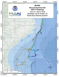
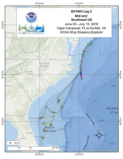
Okeanos Explorer (EX1806): Mid and Southeast US (ROV and Mapping) Operations will include the use of the ship's deep water mapping systems (Kongsberg EM302 multibeam sonar, EK60 split-beam fisheries sonars, Knudsen 3260 chirp sub-bottom profiler sonar, and Teledyne Acoustic Doppler Current Profiler), XBTs in support of multibeam sonar mapping operations, CTD casts, OER's two-body ROV Deep Discoverer and Seirios, and the ship's high-bandwidth satellite connection for continuous real-time ship-to-shore communications. Operations are planned throughout the South Atlantic Bight, offshore Florida, Georgia, South Carolina, North Carolina, and Virginia. |
|
|
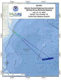
Okeanos Explorer (EX1807): Galway: ASMIWG Bermuda Mapping (Mapping) EX-18-07, from July 12 to August 4, will be the first dedicated government non-transect survey in support of the Atlantic Ocean Research Alliance/Atlantic Seabed Mapping International Working Group (AORA/ASMIWG). AORA/ASMIWG was established by the Trilateral Galway Statement Implementation Committee to identify steps required to implement a seabed mapping strategy to support the objectives of the Galway Statement. As the first U.S. lead mapping effort in support of Galway Statement on Atlantic Ocean Cooperation, EX-18-07 will include onboard and remote participation from Canadian and European Union students and scientists. |
|
|
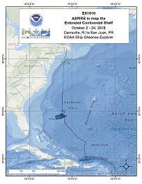
Okeanos Explorer (EX1810): Mapping Deepwater Areas off the Southeast U.S. in Support of the Extended Continental Shelf Project Operations will include the use of the ship's deep water mapping systems (Kongsberg EM302 multibeam sonar, EK60 split-beam fisheries sonars, Knudsen 3260 chirp sub-bottom profiler sonar, and Teledyne Acoustic Doppler Current Profiler), XBT and CTD casts in support of multibeam sonar mapping operations, and the ship's high-bandwidth satellite connection for real-time ship-to-shore communications. Operations are planned south east of Bermuda in the high seas. |
|
|
Okeanos Explorer (EX1811): Oceano Profundo 2018: Exploring Deep-Sea Habitats off Puerto Rico and the U.S. Virgin Islands Operations will include the use of the ship's deep-water mapping systems (Kongsberg EM302 multibeam sonar, EK60 split-beam fisheries sonars, Knudsen 3260 chirp sub-bottom profiler sonar, and Teledyne Acoustic Doppler Current Profiler), XBTs in support of multibeam sonar mapping operations, CTD casts, OER's two-body ROV system (Deep Discoverer and Seirios), and the ship's high-bandwidth satellite connection for continuous ship-to-shore communications. Operations will focus on exploring deep waters (>250 m) in the U.S. exclusive economic zone (EEZ) of the Caribbean Sea, as well as in territorial waters surrounding surrounding Puerto Rico and the U.S. Virgin Islands. |
|
|
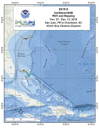
Okeanos Explorer (EX1812): Caribbean/SAB ROV and Mapping Operations will include the use of the ship's deep water mapping systems (Kongsberg EM302 multibeam sonar, EK60 split-beam fisheries sonars, Knudsen 3260 chirp sub-bottom profiler sonar, and Teledyne Acoustic Doppler Current Profiler), XBT casts in support of multibeam sonar mapping operations, OER's two-body ROV Deep Discoverer and Seirios, and the ship's high-bandwidth satellite connection for continuous real-time ship-to-shore communications and the ship's high-bandwidth satellite connection for continuous real-time ship-to-shore communications. Operations are planned in the US EEZ, Dominican Republic, Turks and Caicos Islands and Bahamas. |
|
|
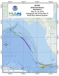
Okeanos Explorer (EX1902): 2019 Field Season Shakedown This shakedown mission, which began in Pascagoula, Mississippi on May 12, 2019 and concluded on May 24, 2019 in Key West, Florida, came after the winter scheduled drydock and dockside shipyard repair period. While underway, 24-hour operations focused on preparing deep-sea mapping and water column sonars and remotely operated vehicle (ROV) systems for the remainder of 2019 expeditions. Three "engineering dives" were conducted during the first part of the expedition. The dives allowed members of the Global Foundation for Ocean Exploration to calibrate the ROV's ultra short baseline (USBL) positioning system, test a new suction sampling device, test on-ship data transfer and telepresence systems, and train new team members. As the dives focused on testing new equipment, no physical samples were collected for later analyses. During the third ROV dive on May 16, while conducting an "engineering dive" to test new remotely operated vehicle (ROV) equipment, the team made an unexpected - and exciting - discovery: the wreck of what is likely a mid-19th century wooden sailing vessel. Mapping shakedown operations during the expedition included calibrating the ship's EM302 multibeam sonar (used to map the seafloor and water column) and the EK60 split-beam sonar (used to explore the water column), integrating and calibrating a new Simrad EK80 split-beam sonar (for further water column exploration), and installing and testing a new sonar synchronization unit (K-Sync - to reduce potential interference between different sonars). |
|
|
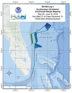
Okeanos Explorer (EX1903L1): Southeastern US Atlantic Continental Margin Mapping During EX1903L1 5342 linear kilometers and 21,724 square kilometers of EM302 data were collected. In addition to bathymetry, these numbers also include multibeam backscatter and multibeam water column data. EX-19-03 Leg 1 operations commenced on May 30th, 2019 in Key West, Florida and concluded on June 14, 2019 in Cape Canaveral, Florida. Operations included a combination of acoustic seabed, water column, and sub-seafloor mapping and one conductivity temperature depth (CTD) cast. Operations focused in the South Atlantic Bight, off the coasts of Florida, Georgia and South Carolina all within the U.S. EEZ. Priority areas were defined with input from the OER ASPIRE 2019 workshop, Bureau of Ocean Energy Management, NOAA Southeast Deep Sea Coral Initiative, NOAA Office of Coast Survey, Seabed 2030 efforts, and the South Atlantic Fisheries Management Council. Strategic mapping objectives included subbottom data collection over key features, multibeam data collection over priority areas requiring coverage development, and multibeam holiday lines completing previous coverage on the Blake Plateau. Mapping objectives also focused on priority areas in order to optimize Remotely Operated Vehicle Dives planned for EX-19-03-Leg02 that followed this cruise. |
|
|
Okeanos Explorer (EX1903L2): Mid and Southeast US (ROV & Mapping) The deepwater areas offshore Florida, Georgia, South Carolina, and North Carolina are some of the least explored areas along the U.S. East Coast. In 2019, NOAA and partners conducted a two-part expedition to map and characterize this area to support priorities put forward by the deep-ocean science and resource management communities. The primary objective of the expedition was to survey deepwater areas offshore of Florida, Georgia, South Carolina and North Carolina in order to provide baseline information to support management and science needs. This two-part expedition used the ship's deepwater mapping systems (Kongsberg EM302 multibeam sonar, Simrad EK60 and EK80 split-beam fisheries sonars, Knudsen 3260 chirp sub-bottom profiler sonar, and Teledyne Acoustic Doppler Current Profiler [ADCP]), NOAA's two-body deepwater remotely operated vehicle (ROV), and a high-bandwidth satellite connection for real-time ship to shore communications. This cruise report details activities associated with the second leg of the Windows to the Deep 2019 expedition (EX1903L2). 19 ROV dives were conducted, ranging in depth from 298 to 3,490 meters (978-11,450 feet) to improve knowledge of unexplored areas within the U.S. Exclusive Economic Zone (EEZ) to inform management needs for sensitive habitats, maritime heritage sites, and potential resources. EX1903L2 also mapped 14,314 square kilometers of seafloor to extend bathymetric mapping coverage in the U.S.EEZ in support of Seabed 2030 and NOAA's goal to map and characterize the U.S. EEZ. Data from this expedition will help to improve our understanding of the deep-ocean habitats of the U.S. continental margin and of the connections between communities throughout the Atlantic Basin. |
|
|
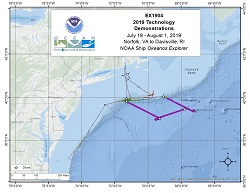
Okeanos Explorer (EX1904): 2019 Technology Demonstration EX-19-04 mapped 7,001 square kilometers of seafloor on and off the continental shelf offshore of Virginia, Maryland, Delaware, New Jersey, New York, Rhode Island and Massachusetts during the 14 days-at-sea. |
|
|
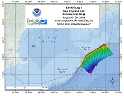
Okeanos Explorer (EX1905L1): New England and Canada Mapping EX-19-05 Leg 1 collected 18,734 square kilometers (5462 square nautical miles) and 4798 linear kilometers of bathymetry and associated water column data; 37 square kilometers of this area were mapped within the U.S. Exclusive Economic Zone in depths greater than 200 meters. EX-19-05-Leg 1 departed from North Kingstown, Rhode Island on August 6, 2019 and arrived in Halifax, Nova Scotia, Canada on August 20, 2019, for a total of 15 days-at-sea. EX-19-05 Leg 1 operations involved a transit northward, crossing the continental shelf followed by focused ocean mapping operations mostly in deep (> 200 m) Canadian waters off the east coast of Nova Scotia. The cruise conducted 24 hour/day exploratory mapping operations to provide initial characterization of the region, as well as to provide data to support more in-depth exploration with remotely operated vehicles (ROVs) planned for the follow-on EX-19-05 Leg 2 expedition. |
|
|
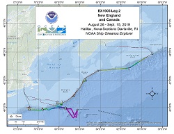
Okeanos Explorer (EX1905L2): New England and Canada ROV and Mapping Using OER's dual-body ROV, the expedition completed 12 successful dives ranging in depth from 306 to 2,668 meters that explored a wide diversity of habitats and geological features, including deep-sea coral and sponge communities, deep-sea fish habitats, midwater habitats, submarine canyons, seamounts, and more. Midwater explorations at depths ranging from 700 to 2,175 meters were conducted during one ROV dive in order to investigate the diversity and abundance of the largely unknown pelagic fauna of the region. Overall, hundreds of different species were observed during ROV dive operations, including several potentially undescribed species and several range extensions. Throughout the expedition, 124 biological samples were collected (35 primary and 89 associated taxa), 26 of which likely represent either range expansions or potential new species. The remainder of the biological samples were collected to support studies on connectivity and biogeographic patterns across the Atlantic Ocean. Six high-density communities of deep-sea corals and sponges were documented during the expedition, including a high-density forest of bamboo corals at depths of 1,100 meters inside Gully Canyon, and a highly diverse and dense assemblage of deep-sea sponges and corals at depths of 2,500-2,650 meters on Retriever Seamount, which is among the deepest known such communities in the region. Additional patches of high-density communities of deep-sea corals and sponges were documented during dives on an unnamed canyon, Kinlan Canyon, Bear Seamount, and Veatch Canyon. Other noteworthy ROV observations included records of three large (> 1 meter) individuals of the endangered Atlantic Halibut, Hippoglossus hippoglossus.Additionally, ROV dives documented various unique geological features, including inactive fluid expulsion features inside Verrill Canyon, evidence of recent sediment transport within Oceanographer Canyon, and a continuous sequence of carbonate rock (>100 meters thick) with near vertical relief at Veatch Canyon. Five geological samples were collected to support laboratory analyses that will increase our understanding of the geological context of this region. |
|
|
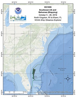
Okeanos Explorer (EX1906): Southeast US and Bahamas, Leg 1 Mapping EX-19-06 collected 20,289 square kilometers (5,915 square nautical miles) and 7,594 linear kilometers of bathymetry and associated water column data. 18,110 square kilometers of this area was mapped within the U.S. Exclusive Economic Zone in depths deeper than 200m. The ship started the cruise from North Kingstown, RI on October 5, 2019 and ended in Miami, Florida on October 26, 2019. EX-19-06 operations involved a transit southward along the edge of the continental shelf followed by focused ocean mapping operations mostly in deep (>200 m) U.S. federal waters off the southeast U.S. Coast on the Blake Plateau. Some limited surveying was also completed along the U.S./Bahamas maritime boundary region. The cruise conducted 24 hour/day exploratory mapping operations to provide initial characterization of the region, as well as to provide data to support more in-depth exploration with remotely operated vehicles (ROVs) planned for the follow-on EX-19-07 expedition. |
|
|
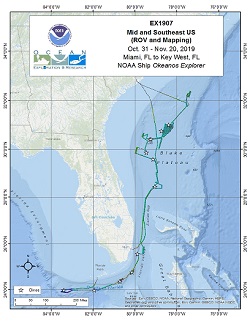
Okeanos Explorer (EX1907): Southeast US and Bahamas, Leg 2 From October 31 to November 20, 2019 the NOAA Office of Ocean Exploration and Research (OER) conducted the 2019 Southeastern U.S. Deep-sea Exploration remotely operated vehicle (ROV) and mapping cruise (EX1907) from Miami, Florida, to Key West, Florida. Twelve ROV dives were completed, and over 12,700 square kilometers were mapped during this expedition. ROV dive operations supported the expedition objectives, including characterizing bottom fish and precious coral habitats, deep-sea coral habitats, seamounts, and fracture zones. During each dive, the ROVs descended to the seafloor and then moved from waypoint to waypoint, documenting the geology and biology of the area. Onboard and shore-based scientists identified encountered organisms to the lowest taxon possible based on data available during real-time assessment. |
|
|
Okeanos Explorer (EX2000): OMAO-5921 (EM304 System Acceptance Test) EX-20-00 departed from Pascagoula, Mississippi on March 3 and arrived in Key West, Florida on March 8, 2020. The primary purpose of this cruise was to perform the sea acceptance trials of the newly installed EM 304 topside unit. The multibeam receive array was replaced in 2018, and the transmit array is the original from the 2007 install. Visiting Kongsberg technicians performed and observed required tests to ensure acceptable functionality of the unit. These tests included a geometric calibration (patch test), speed-noise testing, and accuracy testing with both a shallow and deep reference survey. |
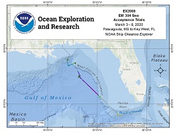
|
|
Okeanos Explorer (EX2101): 2021 EM304 SAT + Mapping Shakedown Between April 14 and May 10, 2021 EX-21-01 performed the sea acceptance testing of the newly installed Kongsberg EM 304 MKII transmit array, conducted mission readiness of the mapping systems through annual testing and calibration, and mapped unexplored areas of the Blake Plateau. In addition to the EM 304 multibeam sonar objectives, EK60/80 split-beam echosounder objectives included acceptance of the newly installed EK80 38 kHz transducer and calibration of each frequency (18, 38, 70, 120, 200 kHz). Other mission readiness objectives included ensuring functionality of all ancillary equipment, including sound speed profiling equipment, updating and refining procedural documents, and defining new procedures for supporting shore-based processing using the Cloud. EX-21-01 collected 22,187 square kilometers of bathymetry and associated water column data, with 18,773 square kilometers being within the U.S. Exclusive Economic Zone and Territorial Sea deeper than 200 m. |

|
|
Okeanos Explorer (EX2102): 2021 Technology Demonstration From May 14-27, 2021, NOAA Ocean Exploration led the 2021 Technology Demonstration on NOAA Ship Okeanos Explorer from Cape Canaveral, Florida, to Norfolk, Virginia. The expedition brought together NOAA's Northwest Fisheries Science Center, NASA's Jet Propulsion Laboratory (NASA JPL), the Woods Hole Oceanographic Institution (WHOI), and the Inner Space Center/University of Rhode Island (ISC/URO) to advance new ocean technologies and sampling techniques. The expedition had three overall objectives; field testing and engineering readiness of WHOI/NASA JPL Orpheus autonomous underwater vehicles, piloting environmental DNA (eDNA) collection for NOAA Ocean Exploration and mapping priority deepwater areas offshore the U.S. Southeast, largely focused on the Blake Plateau. During 14 days at sea, 8 AUV deployments were completed between 12 and 866 meters in depth. Over 724 GB of downlooking AUV 4K video were collected. The AUVs surveyed 30 linear kilometers of seafloor and logged over 16 hours of bottom time. The AUVs spent a total of 32 hours 59 minutes in the water, which included autonomous water column exploration. Twelve CTD rosette casts were completed, most simultaneous with AUV operations. Using the Niskin bottles on the CTD rosette, 120 water samples were collected for post-cruise eDNA analysis. Exploration mapping operations included acoustic data collection using the EM 304 MKII multibeam echosounder, Simrad EK60/80 split-beam echosounders, Knudsen sub-bottom profiler and Acoustic Doppler Profilers. 8,703 square kilometers of largely unmapped seafloor were mapped using the EM 304 with 8,519 square kilometers being within the U.S. Exclusive Economic Zone and Territorial Sea deeper than 200 m. All operations and data collected were in U.S. waters. |
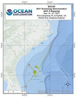
|
|
Okeanos Explorer (EX2103): 2021 ROV Shakedown This Remotely Operated Vehicle (ROV) shakedown expedition aboard NOAA Ship Okeanos Explorer began in Norfolk, Virginia on June 13, 2021 and concluded on June 28, 2021 in Newport, Rhode Island. This was the first time the ROVs Deep Discoverer and Seirios were mobilized and used for ROV dives since the extensive 2021 winter dry dock repair period. While underway, 24-hour operations focused on preparing remotely operated vehicle (ROV) systems for the remainder of 2021 expeditions. Extensive testing, calibration, and troubleshooting was completed for new ROV motors, motor controllers, cameras, lighting, hydraulic systems, and a navigational sonar during 11 ROV dives. The first five dives progressively got to deeper depths ranging from 670 m to 4370 m with the primary objective of new equipment integration and personnel training. The following five dives were conducted on Caryn Seamount, and the mid-Atlantic canyons Toms, Hudson (twice), and Uchupi. The last dive of the expedition was on a recently discovered sonar anomaly that turned out to be a World War II era submarine, the Humaita (ex-USS Muskallunge). Five biological and three geological samples were collected for later analyses from Caryn Seamount and the mid-Atlantic canyons. Mapping operations during the expedition included continued calibrating and troubleshooting of the ship's new EM304 multibeam sonar and transducer array. Additional mapping operations included improving multibeam bathymetry in previously mapped areas, sub-bottom sonar surveys conducted on the Currituck landslide feature off of North Carolina, EK60 water column sonar survey of the diurnal migration above Hudson Canyon, and searching for underwater cultural heritage sites by observing sonar depth and backscatter anomalies. |
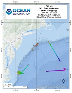
|
|
Okeanos Explorer (EX2104): 2021 North Atlantic Stepping Stones: New England and Corner Rise Seamounts The 2021 North Atlantic Stepping Stones: New England and Corner Rise Seamounts expedition (EX-21-04) was a combined mapping and remotely operated vehicle (ROV) expedition to the seamounts of the Northwest Atlantic that took place between June 30 and July 29, 2021. Operations during this 30-day at sea expedition included a combination of ROV dives in support of NOAA Ocean Exploration and its partner priorities as well as exploratory mapping operations targeting areas containing no or poor quality modern mapping data. The initial focus was on the U.S. Northeast Seamount and high seas areas, however, during the expedition weather altered the planned transect to outside Bermudan waters where three dives took place before rejoining the planned dive sites exploring a total of 19 seamounts and one canyon (Hydrographer) for water column exploration. During the expedition, 20 Deep Discoverer ROV dives were conducted from 300 m to 4187 m water depth for a total of 154 hours of bottom time, and surveyed using EM 304 multibeam sonar 54,710 square km over 30 days at sea. All data associated with this expedition have been archived and are publicly available through the NOAA Archives. |
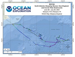
|
|
Okeanos Explorer (EX2105): 2021 U.S. Blake Plateau Mapping 1 (Mapping) From August 15- September 2, 2021, NOAA Ocean Exploration conducted mapping operations on the Blake Plateau within U.S. waters, aiding in closing the gaps within this region. This cruise consisted of a strategic transit from Newport, Rhode Island to the primary working grounds off of the U.S Southeast, aimed at collecting data over previously mapped and potentially new seeps along the edge of the continental shelf. EX-21-05 collected 13,054 square kilometers of bathymetry and associated water column data, 12,989 square kilometers of which were within the U.S. Exclusive Economic Zone and Territorial Sea deeper than 200 m. The cruise concluded in Port Canaveral, FL on September 2, 2021. The exploratory mapping operations conducted during this cruise will provide initial characterization of the region, as well as data to support further exploration with remotely operated vehicles planned for EX-21-07. |
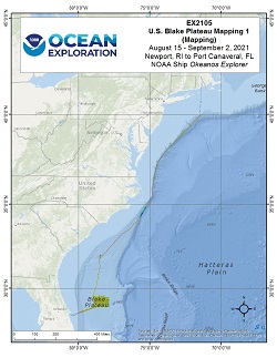
|
|
Okeanos Explorer (EX2106): 2021 U.S. Blake Plateau Mapping 2 (Mapping) From September 5 - September 28, 2021, NOAA Ocean Exploration conducted mapping operations on the Blake Plateau within U.S. waters, aiding in closing the gaps within this region. The second of two cruises focused on mapping this region, EX-21-06 collected 25,800 square kilometers of bathymetry and associated water column data, 25,790 square kilometers of which were within the U.S. Exclusive Economic Zone and Territorial Sea deeper than 200 m. The exploratory mapping operations conducted during this cruise will provide initial characterization of the region, as well as data to support further exploration with remotely operated vehicles planned for EX-21-07. |
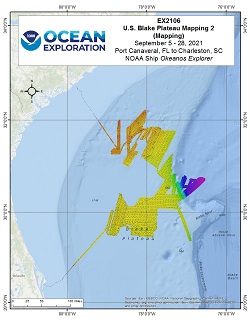
|
|
Okeanos Explorer (EX2107): Windows to the Deep 2021: Blake Plateau The Windows to the Deep 2021: Southeast U.S. ROV and Mapping expedition (EX-21-07) was a combined mapping and remotely operated vehicle (ROV) expedition to the Blake Plateau and Florida Straits that took place between October 26 and November 15, 2021. Operations during this 21-days at sea expedition included a combination of ROV dives in support of NOAA Ocean Exploration and its partner priorities. The primary focus of this expedition was the Blake Plateau, including its escarpment, off the coast of the Southeast U.S., but three dives were also conducted in the western and central Florida Straits due to weather conditions. Overall, 14 dives were completed, including two explorations of the water column, several dives to mound and ridgelike structures likely to be bioherms, two deeper dives to explore the steep Blake Escarpment, and one dive to document a lone sinkhole in the southeast region of the Blake Plateau. ROV dives were conducted from 300 m to 3650 meters water depth for a total of 47 hours of bottom time, and 15,800 square km were mapped using EM 304 multibeam sonar. All data associated with this expedition have been archived and are publicly available through the NOAA Archives. |
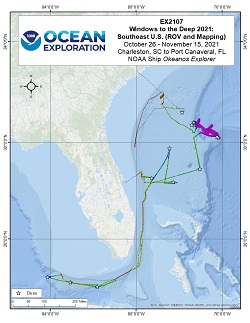
|
|
Okeanos Explorer (EX2201): Mapping & ROV Shakedown From February 23 - March 3, 2022 (Pascagoula, MS to Key West, FL), NOAA Ocean Exploration conducted a shakedown of the remotely operated vehicle (ROV), video, telepresence, and sampling operations as well as mapping and positioning systems aboard NOAA Ship Okeanos Explorer. The ROV engineers tested and calibrated ROVs Deep Discoverer and Seirios' ROV motor controllers, auto position software, lighting system, hydraulic system, ME-20 low-light camera, high-definition ancillary ROV cameras, sector-scanning sonar, as well as tested remote-piloting capabilities of ROV Deep Discoverer. Shakedown and readiness operations for the EM 304 multibeam sonar included a GNSS Azimuth Measurement Subsystem (GAMS) calibration, Patch Test, speed-noise test, coverage extinction data collection, and integration and testing of the newly installed SeaPath 380-R3. In total, the expedition team conducted 7 ROV dives ranging from 480 to 3,420 m depth and collected 4,930 square kilometers of acoustic data during transits and calibrations. The expedition explored the West Florida Shelf and the Straits of Florida offshore the U.S. southeastern coast. The expedition confirmed the location of a shipwreck target, thought to be a 19th century whaler. Corals and sponges were observed 4 out of the 7 surveyed dive sites, with 3 of the 7 containing high diversities of benthic species. A total of 12 samples were collected: 3 geological, 3 biological, and 6 commensal (not including blank samples). |
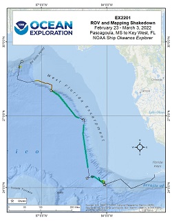
|
|
Okeanos Explorer (EX2202): Caribbean Mapping (MACHC partnership) From March 10 - 28, 2021 (Key West, FL to San Juan, Puerto Rico), NOAA Ocean Exploration conducted mapping operations south of Puerto Rico in U.S. waters, aiding in closing bathymetric gaps within this region. EX-22-02 collected 18,850 square kilometers of bathymetry and associated water column data, 18,033 square kilometers of which were within the U.S. Exclusive Economic Zone and Territorial Sea deeper than 200 m. During mapping operations, NOAA Ocean Exploration simultaneously collected EM 304 multibeam sonar bathymetry observations and Simrad EK60/EK80 split-beam fisheries sonar observations of biologic material in the water column, as well as Knudsen 3260 sub-bottom profiler observations of sub-seafloor geologic structure and sediment. A single CTD cast during the expedition validated deep deployment capabilities in preparation for planned CTD operations on EX-22-03. The exploratory mapping operations conducted during this cruise will provide initial characterization of the region, as well as data to support further exploration. |
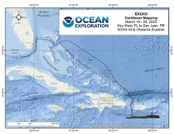
|
|
Okeanos Explorer (EX2203): North Puerto Rico Mapping + drop cam From April 4 - 28, 2022, NOAA Ship Okeanos Explorer sailed to support NOAA Ocean Exploration's Puerto Rico Mapping and Deep-Sea Camera expedition (EX-22-03). The ship departed from San Juan, Puerto Rico. The mission objectives were two-fold: seafloor mapping in U.S waters offshore of Puerto Rico and testing deep-sea camera systems developed by the Multidisciplinary Instrumentation in Support of Oceanography (MISO) Facility at the Woods Hole Oceanographic Institution (WHOI) for potential integration into future NOAA Ocean Exploration operations. The primary mapping area of the expedition was the Muertos Trough region and surrounding seamounts in U.S. Caribbean waters around Puerto Rico. In addition, a transit over the 8,000 m deep Puerto Rico Trench was used to test the limits of the new Kongsberg EM 304 MKII multibeam sonar that was installed in 2021. Upon completion of mapping in the priority areas, the expedition focused on testing the integrated deep-sea camera and conductivity, temperature, and depth (CTD) system to support a number of mission objectives through simultaneous imaging and sampling of the water column. The last portion of the expedition consisted of mapping the high seas and offshore waters of the U.S. East Coast while transiting to the final destination of Newport, Rhode Island. |
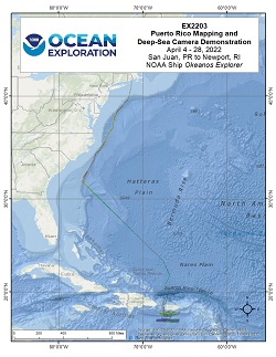
|
|
Okeanos Explorer (EX2204): Voyage to the Ridge 1 (Mapping) From May 14 - June 7, 2022 (Newport, Rhode Island to St. John's, Newfoundland), NOAA Ocean Exploration conducted mapping operations on the Charlie Gibbs Fracture Zone, aiding in closing bathymetric gaps within this region. EX-22-04 collected 46,250 square kilometers of bathymetry and associated water column data. During mapping operations, NOAA Ocean Exploration simultaneously collected EM 304 multibeam sonar bathymetry observations and Simrad EK60/EK80 split-beam fisheries sonar observations of biologic material in the water column, as well as Knudsen 3260 sub-bottom profiler observations of sub-seafloor geologic structure and sediment. Additionally, a calibration of the EK60/EK80 transducers was completed. The exploratory mapping operations conducted during this cruise will provide initial characterization of the region, as well as data to support further exploration. |
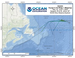
|
|
Okeanos Explorer (EX2205): Voyage to the Ridge 2 (ROV and Mapping) From July 9-30, 2022 (Norfolk, VA to Horta, Faial, Azores) NOAA Ocean Exploration completed the Voyage to the Ridge 2 expedition (EX-22-05), a combined mapping and remotely operated vehicle (ROV) expedition to the Mid-Atlantic Ridge and Azores Plateau. Operations during this 22-days at sea expedition included the completion of 10 successful ROV exploration dives in the vicinity the Azores and the Mid-Atlantic Ridge north of the Azores. ROV dives were conducted in water depths ranging from 420 m to 3350 m for a total of almost 53 hours of bottom time. EX-22-05 also collected 49,417 square kilometers of seafloor bathymetry and associated water column data using an EM304 multibeam sonar. |
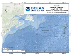
|
|
Okeanos Explorer (EX2206): Voyage to the Ridge 3 (ROV and Mapping) From August 6 - September 2, 2022 (Horta, Faial, Azores to San Juan, Puerto Rico) NOAA Ocean Exploration completed the Voyage to the Ridge 3 expedition (EX-22-06), a combined mapping and remotely operated vehicle (ROV) expedition to the Mid-Atlantic Ridge and Azores Plateau, Mid-Atlantic Ridge, and U.S. waters in the vicinity of Puerto Rico and the U.S. Virgin Islands. Operations during this 28-day expedition included the completion of 9 successful ROV exploration dives in the vicinity of the Azores, the Mid-Atlantic Ridge south of the Azores, and Puerto Rico. ROV dives were conducted in water depths ranging from 250 m to 6000 m for a total of 41 hours of bottom time. EX-22-06 also collected 56,769 square kilometers of seafloor bathymetry and associated water column data using an EM304 multibeam sonar. All data associated with this expedition have been archived and are publicly available through the NOAA Archives. |
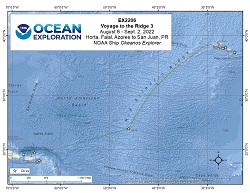
|
|
Okeanos Explorer (EX2208): EXPRESS: West Coast Exploration 1 (Mapping) From October 16-November 3, 2022 (San Diego, California to Newport, Oregon), NOAA Ocean Exploration conducted mapping operations off the coast of California and Oregon in U.S. waters, aiding in closing bathymetric gaps within this region. Expedition EX-22-08 collected 32,416 square kilometers of bathymetry and associated water column data, 22,313 square kilometers of which were within the U.S. Exclusive Economic Zone and Territorial Sea deeper than 200 m, while 10,104 square kilometers were collected in international waters. During mapping operations, NOAA Ocean Exploration simultaneously collected EM 304 multibeam sonar bathymetry observations and Simrad EK60/EK80 split-beam fisheries sonar observations of biologic material in the water column, as well as Knudsen 3260 sub-bottom profiler observations of sub-seafloor geologic structure and sediment. A detailed sub-bottom survey targeted previously-identified sponge reefs in the Channel Islands National Marine Sanctuary. The exploratory mapping operations conducted during this cruise will provide initial characterization of the region, as well as data to support further exploration. |
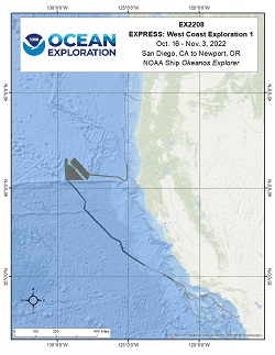
|
|
Okeanos Explorer (EX2301): 2023 Shakedown + EXPRESS West Coast Exploration From April 13-27, 2023 (Portland, Oregon, to Seattle, Washington), NOAA Ocean Exploration conducted the 2023 Shakedown + EXPRESS West Coast Exploration expedition (EX2301), an ROV and Mapping expedition to a shakedown the remotely operated vehicle (ROV), video, telepresence, seafloor mapping, and sampling operations aboard NOAA Ship Okeanos Explorer, as well as explore deep waters off the west coast of the United States. Operations during this 15-day expedition included the completion of 9 successful remotely operated vehicle (ROV) dives, which were conducted in water depths ranging from 650 m to 3960 m for approximately 45:34 hours of bottom time and resulted in the collection of 92 samples. |

|
|
Okeanos Explorer (EX2302): Seascape Alaska: Aleutians Explorations 1 From May 5 - 26, 2023 (Seattle, Washington, to Dutch Harbor, Alaska), NOAA Ocean Exploration conducted transit and mapping operations off the coast of Washington State, the Gulf of Alaska, and along the Aleutian Islands. The ship departed from Seattle, Washington. Expedition EX-23-02 collected data supporting the Seascape Alaska initiative and used a small, human portable AUV in partnership with the Defense POW/MIA Accounting Agency (DPAA) to aid in locating an aircraft lost in the Aleutian Islands during World War II. Transit mapping data was collected from Seattle, Washington, across the Gulf of Alaska, and along the northern and southern edges of the Aleutian Islands, extending from approximately Unga Island to Gareloi Island. Primary mapping activities focused on the area connecting the Aleutian Arc and the southern end of Bowers Ridge and the area surrounding Bogoslof Island. The ship returned to port in Dutch Harbor, Alaska. The exploratory mapping operations conducted on this expedition will aid in future characterization of these unexplored areas and help initial characterization in the region. |

|
|
Okeanos Explorer (EX2303): Seascape Alaska 2: Aleutians Deepwater Mapping From June 5-20, 2023 (Dutch Harbor, Alaska to Kodiak, Alaska), NOAA Ocean Exploration conducted mapping operations off the coast of the Aleutian Islands in U.S. waters, aiding in closing bathymetric gaps within this region. Expedition EX2303 collected 37,601 square kilometers of bathymetry and associated water column within the U.S. Exclusive Economic Zone and Territorial Sea deeper than 200 m. During mapping operations, NOAA Ocean Exploration simultaneously collected EM 304 multibeam sonar bathymetry observations and Simrad EK60/EK80 split-beam fisheries sonar observations of biologic material in the water column, as well as Knudsen 3260 sub-bottom profiler observations of sub-seafloor geologic structure and sediment. A focused survey region targeted potential geological hazards along the Aleutian Trench. During the expedition, one CTD cast collected water samples for environmental DNA (eDNA) analysis. The exploratory mapping operations conducted during this cruise will provide initial characterization of the region, as well as data to support further exploration. |

|
|
Okeanos Explorer (EX2305): Seascape Alaska 4: Gulf of Alaska Deepwater Mapping From August 1 - August 17, 2023 (Unalaska, Alaska to Kodiak, Alaska), NOAA Ocean Exploration completed the expedition Seascape Alaska 4: Gulf of Alaska Mapping (EX2305). Mapping operations during this 17-day expedition aided in closing bathymetric gaps off the coast of the Aleutian Islands and in the Gulf of Alaska. EX2305 collected 23,591 square kilometers of seafloor bathymetry within the U.S. Exclusive Economic Zone deeper than 200 m. During mapping operations, NOAA Ocean Exploration simultaneously collected EM 304 multibeam sonar bathymetry observations and Simrad EK60/EK80 split-beam fisheries sonar observations of biologic material in the water column, as well as Knudsen 3260 sub-bottom profiler observations of sub-seafloor geologic structure and sediment. A focused survey region targeted seamounts in the Gulf of Alaska. During the expedition, an EK calibration was completed for the 18, 38, 70, 120, and 200 kHz frequency sonars. The exploratory mapping operations conducted during this cruise will provide initial characterization of the region, as well as data to support further exploration. All data associated with this expedition will be archived within 120 days of the end of the expedition and will be publicly available through the NOAA Archives. |

|
|
Okeanos Explorer (EX2307): Seascape Alaska 6: Gulf of Alaska Transit Mapping From September 23 - October 14, 2023 (Seward, Alaska to San Francisco, California), NOAA Ocean Exploration completed Seascape Alaska 6: Gulf of Alaska Transit Mapping (EX2307). Operations during this 22-day expedition aided in closing bathymetric gaps in the Gulf of Alaska, British Columbia, Canada, and off the coasts of Washington, Oregon, and California. EX2307 collected 47,899 square kilometers of seafloor bathymetry, of which 40,108 square kilometers were within the U.S. Exclusive Economic Zone deeper than 200 m. During mapping operations, NOAA Ocean Exploration simultaneously collected EM 304 multibeam sonar bathymetry observations and Simrad EK60/EK80 split-beam fisheries sonar observations of biologic material in the water column, as well as Knudsen 3260 sub-bottom profiler observations of sub-seafloor geologic structure and sediment. Focused survey regions included closing bathymetric gaps in the Gulf of Alaska, Canada, and California. An additional focused survey in the Cascadia margin off the coast of Washington improved data quality in a region of interest for geological hazards. The exploratory mapping operations conducted during this expedition will provide initial characterization of the region, as well as data to support further exploration. |
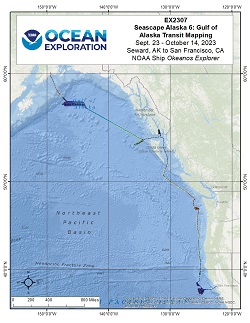
|
|
Okeanos Explorer (EX2308): EXPRESS:Exploration of Central California Coast (USM AUV + Mapping) From October 21 - November 10, 2023 (San Francisco, California to San Francisco, California) NOAA Ocean Exploration conducted EXPRESS: Exploration of Central California Coast (EX2308), an AUV and mapping expedition, along the central Californian coast. Operations during this 21-day expedition included the completion of 5 successful autonomous underwater vehicle (AUV) dives with the University of Southern Mississippi's (an OECI affiliate) AUVs Eagle Ray and Mola Mola, conducted in water depths ranging from ~400 m to 1954 m for approximately 66 hours and 55 minutes of dive time. EX2308 also collected 22,259 sq. km of seafloor bathymetry and associated water column data using the EM304 multibeam sonar, all within the US EEZ. All data associated with this expedition will be archived within 120 days of the end of the expedition and will be publically available through NOAA Archives. |

|
|
Okeanos Explorer (EX2309): EXPRESS: West Exploration ROV + VIP Dives From November 30 - December 8, 2023 (San Francisco, California to San Francisco, California) NOAA Ocean Exploration conducted EXPRESS: West Coast Exploration (EX2309), an AUV and mapping expedition, along the central Californian coast. Operations during this 9-day expedition included mapping operations and drop camera operations in the Channel Islands National Marine Sanctuary and along the Central California coast. Unfortunately due to weather and logistics onboard the ship, only one AUV dive was conducted. This dive was located in CINMS and corresponds to a calibration that was needed to complete the dataset for EX2308 in collaboration with the University of Southern Mississippi's (an OECI affiliate) AUVs Eagle Ray. Five drop camera deployments were conducted in partnership with Ocean Discovery League as part of the development of their new lightweight, low cost camera system, Maka Nui. EX2309 also collected 6,375 square kilometers of seafloor bathymetry and associated water column data using the EM304 multibeam sonar, all within the US EEZ. Data associated with this expedition will be publically available through NOAA Archives. |

|
")
