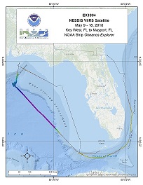
Okeanos Explorer (EX1804): VIIRS (Mapping, Third Party) SE US
Vessel: NOAA Ship Okeanos Explorer; Expedition Dates: May 09, 2018 to May 18, 2018
Ports: Key West, FL to Mayport, FL
Project Principals: Michael White, NOAA/OAR/OER (Expedition Coordinator and Mapping Lead)

While this Okeanos Explorer mission will be managed by NESDIS's Visible Infrared Imaging Radiometer Suite (VIIRS) Satellite project, OER will have a mapping lead, Mike White, onboard to perform opportunistic multibeam surveying. OER data management will manage these data in the same manner as other Okeanos missions.
Expedition Data and Resources
| Mapping Summary Report (PDF - .798 MB) | Open | Click to open link |
| Mapping Products | Download | Use zip utility to open file |
| Shipboard CTDs | Download | Use zip utility to open file |
| Ship Navigation Data (ASCII) | Download | Use zip utility to open file |
| Ship SCS/Sensor Data (ASCII) | Download | Use zip utility to open file |
| Ship SCS/Sensor Data (NetCDF) | Open | NetCDF file format: Special software needed to read |
Educational Resources
| Education Materials Collection | Open | Click to open Education Materials |
Publication Resources
| NOAA Central Library OER Bibliography | Open | Click to open OER Bibliography |
Links to Archived Data and Resources
| Multibeam Archive Collection | Get Data | Click to Access Archive |
| Water Column Sonar Archive Collection | Get Data | Click to Access Archive |
| Trackline Data (Single-beam and Sub-bottom) | Get Data | Click to Access Archive |
| Physical, Chemical, and Biological Archive Collection | Get Data | Click to Access Archive |
| Expedition Metadata | Open | Click to view Metadata in xml format |

