
Mapping & ROV Shakedown
Vessel: NOAA Ship Okeanos Explorer; Expedition Dates: February 17, 2022 to February 26, 2022
Ports: Key West, FL to Key West, FL
Project Principals: Kimberly Galvez, NOAA/OAR/OER (Expedition Coordinator); Sam Candio, NOAA/OAR/OER (Mapping Lead)
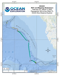
From February 23 - March 3, 2022 (Pascagoula, MS to Key West, FL), NOAA Ocean Exploration conducted a shakedown of the remotely operated vehicle (ROV), video, telepresence, and sampling operations as well as mapping and positioning systems aboard NOAA Ship Okeanos Explorer. The ROV engineers tested and calibrated ROVs Deep Discoverer and Seiriosí ROV motor controllers, auto position software, lighting system, hydraulic system, ME-20 low-light camera, high-definition ancillary ROV cameras, sector-scanning sonar, as well as tested remote-piloting capabilities of ROV Deep Discoverer. Shakedown and readiness operations for the EM 304 multibeam sonar included a GNSS Azimuth Measurement Subsystem (GAMS) calibration, Patch Test, speed-noise test, coverage extinction data collection, and integration and testing of the newly installed SeaPath 380-R3. In total, the expedition team conducted 7 ROV dives ranging from 480 to 3,420 m depth and collected 4,930 square kilometers of acoustic data during transits and calibrations. The expedition explored the West Florida Shelf and the Straits of Florida offshore the U.S. southeastern coast. The expedition confirmed the location of a shipwreck target, thought to be a 19th century whaler. Corals and sponges were observed 4 out of the 7 surveyed dive sites, with 3 of the 7 containing high diversities of benthic species. A total of 12 samples were collected: 3 geological, 3 biological, and 6 commensal (not including blank samples).
Expedition Data and Resources
| Ship Navigation Data (ASCII) | Download | Use zip utility to open file |
| Ship SCS/Sensor Data (ASCII) | Download | Use zip utility to open file |
| Ship SCS/Sensor Data (NetCDF) | Open | NetCDF file format: Special software needed to read |
| Bulk Data Download | Download | Use zip utility to open file |
| Shipboard CTDs | Download | Use zip utility to open file |
| Mapping Products | Download | Use zip utility to open file |
Submersible Data and Resources
| Dive Track KMLs | Download | Use zip utility to open file |
| ROV Dive Event Logs | Open | Click to open link |
| Cruise Video Collection Self-Service Portal | Open | Click to open link |
| Specimens Collected During Dive Operations | Download | Click to open link |
| Submersible Raw Navigation/Sensor Data (ASCII) | Download | Click to open link |
Collected Specimen Repositories
| Smithsonian National Museum of Natural History (Biological Samples) | Open | Click to visit repository website |
| Oregon State University's Marine Geology Repository | Open | Click to visit repository website |
Educational Resources
| Education Materials Collection | Open | Click to open Education Materials |
Links to Archived Data and Resources
| Multibeam Archive Collection | Get Data | Click to Access Archive |
| Water Column Sonar Archive Collection | Get Data | Click to Access Archive |
| Single-beam and Sub-bottom Data Archive Collection | Get Data | Click to Access Archive |
| Physical, Chemical, and Biological Archive Collection | Get Data | Click to Access Archive |
| Expedition Metadata | Open | Click to view Metadata in xml format |
Mississippi Mud
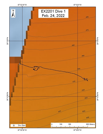
Area
Mississippi Mud; Northern area of Gulf of Mexico
Overview
| Date: | February 24, 2022 |
| Max Depth: | 489.7 Meters |
| Bottom Time: | 2 Hours 51 Minutes 30 Seconds |
Purpose
The first engineering dive of the ROV Shakedown. Primary objectives include testing new motors, motor controllers, lights, cameras, and hydraulic systems on the ROVs.
Download & View Files
| Dive Summary Report (PDF - 673 KB) | View/Download | Requires Adobe Acrobat Reader to view the Dive Summary Report |
| Dive Track (KML - 10 KB) | View/Download | Requires Google Earth or equivalent client to view the Dive Track |
| ROV Ancillary Data (Zip - 14.9 MB) | Download | Link takes you to a public FTP server |
| ROV CTD/Sensor Data (Zip - 3.27 MB) | Download | Link takes you to a public FTP server |
| Camera Platform Sensor Data (Zip - 3.04 MB) | Download | Link takes you to a public FTP server |
| Low-Resolution Video Clips (Zip - 6.29 GB) | Download | Link takes you to a public FTP server |
| Underwater Still Images (Zip - 35.8 MB) | Download | Link takes you to a public FTP server |
| Dive Video Collection Self-Service Portal | Open | Link takes you to an online video discovery and access tool |
UCH Dive
Area
UCH Dive; Northern Gulf of Mexico
Overview
| Date: | February 25, 2022 |
| Max Depth: | 1847.3 Meters |
| Bottom Time: | 5 Hours 36 Minutes 52 Seconds |
Purpose
Engineering focus with an approach on a UCH site.
Download & View Files
| Dive Summary Report (PDF - 726 KB) | View/Download | Requires Adobe Acrobat Reader to view the Dive Summary Report |
| Low-Resolution Video Clips (Zip - 12.8 GB) | Download | Link takes you to a public FTP server |
| Underwater Still Images (Zip - 100 MB) | Download | Link takes you to a public FTP server |
| Dive Video Collection Self-Service Portal | Open | Link takes you to an online video discovery and access tool |
Canyon Terrace
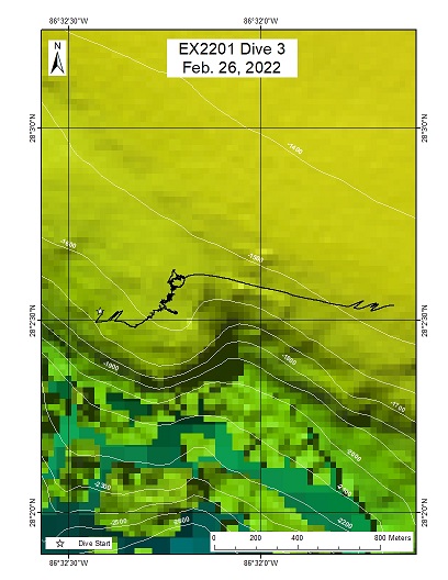
Area
Canyon Terrace; West Florida Shelf - Gulf of Mexico
Overview
| Date: | February 26, 2022 |
| Max Depth: | 1578.3 Meters |
| Bottom Time: | 3 Hours 9 Minutes 5 Seconds |
Purpose
Engineering focus
Download & View Files
| Dive Summary Report (PDF - 718 KB) | View/Download | Requires Adobe Acrobat Reader to view the Dive Summary Report |
| Dive Track (KML - 79.7 KB) | View/Download | Requires Google Earth or equivalent client to view the Dive Track |
| ROV Ancillary Data (Zip - 2.44 MB) | Download | Link takes you to a public FTP server |
| ROV CTD/Sensor Data (Zip - 4.33 MB) | Download | Link takes you to a public FTP server |
| Camera Platform Sensor Data (Zip - 4.01 MB) | Download | Link takes you to a public FTP server |
| Low-Resolution Video Clips (Zip - 9.10 GB) | Download | Link takes you to a public FTP server |
| Underwater Still Images (Zip - 37.8 MB) | Download | Link takes you to a public FTP server |
| Dive Video Collection Self-Service Portal | Open | Link takes you to an online video discovery and access tool |
"Canyon Step"
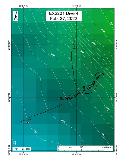
Area
"Canyon Step"; West Florida Shelf
Overview
| Date: | February 27, 2022 |
| Max Depth: | 3015.9 Meters |
| Bottom Time: | 4 Hours 26 Minutes 30 Seconds |
Purpose
Engineering focus
Download & View Files
| Dive Summary Report (PDF - 810 KB) | View/Download | Requires Adobe Acrobat Reader to view the Dive Summary Report |
| Dive Track (KML - 81 KB) | View/Download | Requires Google Earth or equivalent client to view the Dive Track |
| ROV Ancillary Data (Zip - 3.57 MB) | Download | Link takes you to a public FTP server |
| ROV CTD/Sensor Data (Zip - 6.33 MB) | Download | Link takes you to a public FTP server |
| Camera Platform Sensor Data (Zip - 5.48 MB) | Download | Link takes you to a public FTP server |
| Low-Resolution Video Clips (Zip - 12.7 GB) | Download | Link takes you to a public FTP server |
| Underwater Still Images (Zip - 74.3 MB) | Download | Link takes you to a public FTP server |
| Dive Video Collection Self-Service Portal | Open | Link takes you to an online video discovery and access tool |
Abyssal Plain & midwater
Area
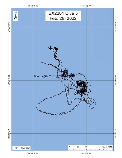
Abyssal Plain & midwater; Southwest Straits of Florida
Overview
| Date: | February 28, 2022 |
| Max Depth: | 3419.7 Meters |
| Bottom Time: | 0 Hours 37 Minutes 14 Seconds |
Purpose
Engineering objectives
Download & View Files
| Dive Summary Report (PDF - 612 KB) | View/Download | Requires Adobe Acrobat Reader to view the Dive Summary Report |
| Dive Track (KML - 77.1 KB) | View/Download | Requires Google Earth or equivalent client to view the Dive Track |
| ROV Ancillary Data (Zip - 8.86 MB) | Download | Link takes you to a public FTP server |
| ROV CTD/Sensor Data (Zip - 6.01 MB) | Download | Link takes you to a public FTP server |
| Camera Platform Sensor Data (Zip - 5.27 MB) | Download | Link takes you to a public FTP server |
| Low-Resolution Video Clips (Zip - 11.5 GB) | Download | Link takes you to a public FTP server |
| Underwater Still Images (Zip - 43.7 MB) | Download | Link takes you to a public FTP server |
| Dive Video Collection Self-Service Portal | Open | Link takes you to an online video discovery and access tool |
Southernmost Canyon
Area
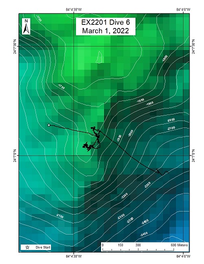
Southernmost Canyon; Straits of Florida
Overview
| Date: | March 01, 2022 |
| Max Depth: | 1841.9 Meters |
| Bottom Time: | 5 Hours 56 Minutes 29 Seconds |
Purpose
Engineering focus
Download & View Files
| Dive Summary Report (PDF - 916 KB) | View/Download | Requires Adobe Acrobat Reader to view the Dive Summary Report |
| Dive Track (KML - 78.5 KB) | View/Download | Requires Google Earth or equivalent client to view the Dive Track |
| ROV Ancillary Data (Zip - 9.2 MB) | Download | Link takes you to a public FTP server |
| ROV CTD/Sensor Data (Zip - 6.3 MB) | Download | Link takes you to a public FTP server |
| Camera Platform Sensor Data (Zip - 5.32 MB) | Download | Link takes you to a public FTP server |
| Low-Resolution Video Clips (Zip - 11.9 GB) | Download | Link takes you to a public FTP server |
| Underwater Still Images (Zip - 115 MB) | Download | Link takes you to a public FTP server |
| Dive Video Collection Self-Service Portal | Open | Link takes you to an online video discovery and access tool |
Southernmost Most Canyon Ridge 2
Area
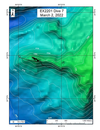
Southernmost Most Canyon Ridge 2; Straits of Florida
Overview
| Date: | March 02, 2022 |
| Max Depth: | 1749.9 Meters |
| Bottom Time: | 5 Hours 34 Minutes 41 Seconds |
Purpose
Complete last of Engineering objectives and explore a previously unexplored area of the Straits of Florida.
Download & View Files
| Dive Summary Report (PDF - 604 KB) | View/Download | Requires Adobe Acrobat Reader to view the Dive Summary Report |
| Dive Track (KML - 81.3 KB) | View/Download | Requires Google Earth or equivalent client to view the Dive Track |
| ROV Ancillary Data (Zip - 9.77 MB) | Download | Link takes you to a public FTP server |
| ROV CTD/Sensor Data (Zip - 6.46 MB) | Download | Link takes you to a public FTP server |
| Camera Platform Sensor Data (Zip - 5.45 MB) | Download | Link takes you to a public FTP server |
| Low-Resolution Video Clips (Zip - 12.7 GB) | Download | Link takes you to a public FTP server |
| Underwater Still Images (Zip - 121 MB) | Download | Link takes you to a public FTP server |
| Dive Video Collection Self-Service Portal | Open | Link takes you to an online video discovery and access tool |

