
Okeanos Explorer (EX1806): Mid and Southeast US (ROV and Mapping)
Vessel: NOAA Ship Okeanos Explorer; Expedition Dates: June 13, 2018 to July 02, 2018
Ports: Charleston, SC to Norfolk, VA
Project Principals: Kasey Cantwell, NOAA/OAR/OER (Expedition Coordinator); Derek Sowers, NOAA/OAR/OER (Mapping Lead)
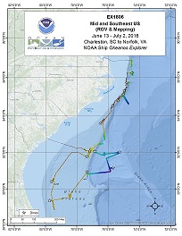
Operations will include the use of the ship's deep water mapping systems (Kongsberg EM302 multibeam sonar, EK60 split-beam fisheries sonars, Knudsen 3260 chirp sub-bottom profiler sonar, and Teledyne Acoustic Doppler Current Profiler), XBTs in support of multibeam sonar mapping operations, CTD casts, OER's two-body ROV Deep Discoverer and Seirios, and the ship's high-bandwidth satellite connection for continuous real-time ship-to-shore communications. Operations are planned throughout the South Atlantic Bight, offshore Florida, Georgia, South Carolina, North Carolina, and Virginia.
Expedition Data and Resources
| Ship Navigation Data (ASCII) | Download | Use zip utility to open file |
| Ship SCS/Sensor Data (ASCII) | Download | Use zip utility to open file |
| Ship SCS/Sensor Data (NetCDF) | Open | NetCDF file format: Special software needed to read |
| Shipboard CTDs | Download | Use zip utility to open file |
| Mapping Products | Download | Use zip utility to open file |
| GIS Products | Download | Use zip utility to open file |
Submersible Data and Resources
| Dive Track KMLs | Download | Use zip utility to open file |
| Event Logs | Open | Click to open link |
| Cruise Video Collection Self-Service Portal | Open | Click to open link |
| Collected Specimens | Open | Click to open link |
| Submersible Navigation/Sensor Data (ASCII) | Download | Use zip utility to open file |
Collected Specimen Repositories
| Smithsonian Institution's National Museum of Natural History Research and Collections (Biological Samples) | Open | Click to visit repository website |
| Ocean Genome Legacy Center (OGL) at Northeastern University | Open | Click to visit repository website |
| Oregon State University's Marine Geology Repository | Open | Click to visit repository website |
Educational Resources
| Expedition Education Module | Open | Click to open Education Module |
| Lesson Plans (K-12) | Open | Click to open Lesson Plans |
| Education Materials Collection | Open | Click to open Education Materials |
Links to Archived Data and Resources
| Multibeam Archive Collection | Get Data | Click to Access Archive |
| Water Column Sonar Archive Collection | Get Data | Click to Access Archive |
| Trackline Data (Single-beam and Sub-bottom) | Get Data | Click to Access Archive |
| Physical, Chemical, and Biological Archive Collection | Get Data | Click to Access Archive |
| Expedition Metadata | Open | Click to view Metadata in xml format |
Blake Escarpment North
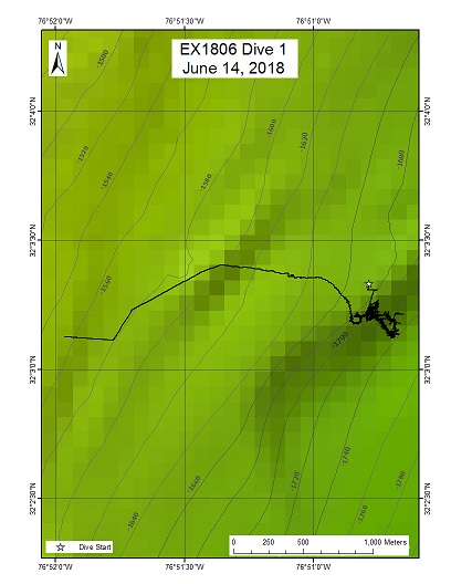
Area
Blake Escarpment North; Blake Escarpment, Southeast US Continental Margin
Overview
| Date: | June 14, 2018 |
| Max Depth: | 1736 Meters |
| Bottom Time: | 5 Hours 20 Minutes 55 Seconds |
Purpose
The primary objective for this dive was to characterize the distribution and abundance of benthic fauna at depths greater than 1500 m. A comparison of the diversity/distribution of coral and sponge communities across the region and to the broader Atlantic is of particular importance to understanding biogeography and connectivity of communities in the Atlantic. This site was proposed by Peter Etnoyer in support of SEDCI objectives, as an unexplored area with potential habitat suitability for corals and sponges. This region was first mapped during EX-18-05 and new information will inform biogeographic patterns in the region.
Download & View Files
| Dive Summary Report (PDF - 1.41 MB) | View/Download | Requires Adobe Acrobat Reader to view the Dive Summary Report |
| Dive Track (KML - 68.2 KB) | View/Download | Requires Google Earth or equivalent client to view the Dive Track |
| ROV Ancillary Data (Zip - 4.27 MB) | Download | Link takes you to a public FTP server |
| ROV CTD/Sensor Data (Zip - 5.52 MB) | Download | Link takes you to a public FTP server |
| Camera Platform Sensor Data (Zip - 17.1 MB) | Download | Link takes you to a public FTP server |
| Low-Resolution Video Clips (Zip - 10.8 GB) | Download | Link takes you to a public FTP server |
| Underwater Still Images (Zip - 181 MB) | Download | Link takes you to a public FTP server |
| Dive Video Collection Self-Service Portal | Open | Link takes you to an online video discovery and access tool |
Blake Ridge
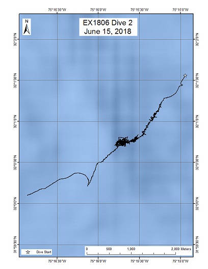
Area
Blake Ridge; Blake Ridge, Southeast US Continental Margin
Overview
| Date: | June 15, 2018 |
| Max Depth: | 3424 Meters |
| Bottom Time: | 3 Hours 52 Minutes 18 Seconds |
Purpose
This dive is part of a series that investigate the similarities and differences in community composition among deepwater habitats of the SE US continental margin. The primary objective for this dive is to characterize the distribution and abundance of benthic fauna at depths greater than 3000 m. A comparison of the diversity/distribution of coral and sponge communities across the region and to the broader Atlantic is of particular importance to understanding biogeography and connectivity of communities in the Atlantic. This site was proposed by Peter Etnoyer in support of SEDCI objectives, as an unexplored area with potential habitat suitability for corals and sponges. This region was first mapped during the Extended Continental Shelf initiative (UNH-CCOM/NOAA), which provided excellent bathymetry and backscatter imagery. New information acquired from this dive will improve understanding of biogeographic patterns and related geologic features in the region.
Download & View Files
| Dive Summary Report (PDF - 1.52 MB) | View/Download | Requires Adobe Acrobat Reader to view the Dive Summary Report |
| Dive Track (KML - 68.8 KB) | View/Download | Requires Google Earth or equivalent client to view the Dive Track |
| ROV Ancillary Data (Zip - 5.22 MB) | Download | Link takes you to a public FTP server |
| ROV CTD/Sensor Data (Zip - 7.39 MB) | Download | Link takes you to a public FTP server |
| Camera Platform Sensor Data (Zip - 23.5 MB) | Download | Link takes you to a public FTP server |
| Low-Resolution Video Clips (Zip - 14.1 GB) | Download | Link takes you to a public FTP server |
| Underwater Still Images (Zip - 112 MB) | Download | Link takes you to a public FTP server |
| Dive Video Collection Self-Service Portal | Open | Link takes you to an online video discovery and access tool |
Giant Bedforms
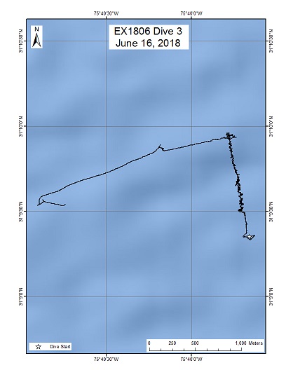
Area
Giant Bedforms; Blake Ridge, Southeast US Continental Margin
Overview
| Date: | June 16, 2018 |
| Max Depth: | 3358 Meters |
| Bottom Time: | 4 Hours 31 Minutes 17 Seconds |
Purpose
Multibeam maps of the area show a zone of irregular, poorly resolved features that may be current-generated bedforms. The objective of working here is to learn about large bedform evolution under current flow. There is uncertainty as to the origin of these bedforms. Roger Flood of Stony Brook, who proposed the dive interprets the irregular topography as bedforms formed by current flow, while others who are studying this area suggest that underlying gas hydrates may cause faulting and seeps, leading to the topography. Hydrates are known to occur in this general vicinity and there could be venting along faults in the area. Prior Alvin dive sites were nearby (1329-1332), but no dives have been made in this portion of the US EEZ.
Download & View Files
| Dive Summary Report (PDF - 1.14 MB) | View/Download | Requires Adobe Acrobat Reader to view the Dive Summary Report |
| Dive Track (KML - 68.4 KB) | View/Download | Requires Google Earth or equivalent client to view the Dive Track |
| ROV Ancillary Data (Zip - 4.32 MB) | Download | Link takes you to a public FTP server |
| ROV CTD/Sensor Data (Zip - 6.3 MB) | Download | Link takes you to a public FTP server |
| Camera Platform Sensor Data (Zip - 19.9 MB) | Download | Link takes you to a public FTP server |
| Low-Resolution Video Clips (Zip - 11.9 GB) | Download | Link takes you to a public FTP server |
| Underwater Still Images (Zip - 64.3 MB) | Download | Link takes you to a public FTP server |
| Dive Video Collection Self-Service Portal | Open | Link takes you to an online video discovery and access tool |
Blake Escarpment South
Area
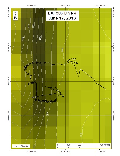
Blake Escarpment South; Blake Escarpment, Southeast US Continental Margin
Overview
| Date: | June 17, 2018 |
| Max Depth: | 1321 Meters |
| Bottom Time: | 5 Hours 52 Minutes 57 Seconds |
Purpose
This dive is part of a series that will investigate the similarities and differences in community composition between deepwater habitats of the SE US continental margin. During this dive, the ROV Deep Discoverer was proposed to explore a rocky feature on the Blake Escarpment, the outer edge of the Blake Plateau offshore the Georgia coast. The dive's primary objective was to characterize the distribution and abundance of benthic fauna at depths between 1200 and 1400 m. A comparison of the diversity/distribution of coral and sponge communities across the region and to the broader Atlantic is of particular importance to understanding biogeography and connectivity of communities in the Atlantic. This site was proposed by Peter Etnoyer in support of SEDCI objectives, as an unexplored area with potential habitat suitability for corals and sponges. This region was first mapped during EX-18-05 and new information will inform biogeographic patterns in the region.
Download & View Files
| Dive Summary Report (PDF - 2.03 MB) | View/Download | Requires Adobe Acrobat Reader to view the Dive Summary Report |
| Dive Track (KML - 68.4 KB) | View/Download | Requires Google Earth or equivalent client to view the Dive Track |
| ROV Ancillary Data (Zip - 5.68 MB) | Download | Link takes you to a public FTP server |
| ROV CTD/Sensor Data (Zip - 7.33 MB) | Download | Link takes you to a public FTP server |
| Camera Platform Sensor Data (Zip - 20.9 MB) | Download | Link takes you to a public FTP server |
| Low-Resolution Video Clips (Zip - 14.5 GB) | Download | Link takes you to a public FTP server |
| Underwater Still Images (Zip - 263 MB) | Download | Link takes you to a public FTP server |
| Dive Video Collection Self-Service Portal | Open | Link takes you to an online video discovery and access tool |
Stetson Mesa South
Area
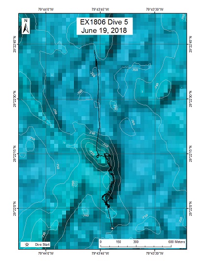
Stetson Mesa South; Blake Plateau (Million Mounds)
Overview
| Date: | June 19, 2018 |
| Max Depth: | 734 Meters |
| Bottom Time: | 6 Hours 35 Minutes 35 Seconds |
Purpose
This dive is part of a series that investigates the similarities and differences in community composition between deepwater habitats of the SE US continental margin. The site was proposed by Tom Hourigan (NOAA Deep Sea Coral Research and Technology Program) and Matthew Poti (NOAA NCCOS) as an unexplored area with potential habitat suitability for deep sea corals. The ROV Deep Discoverer explored a trio of mound features located approximately 200 km southeast of Jacksonville, Florida. The three adjacent mounds are located directly in the path of the Gulf Stream. Multibeam data shows many mound features at 400-800 m throughout the Stetson Mesa. These mounds appear to be enormous aggregations of deep-sea coral rubble. This area shows high habitat suitability for deep-sea corals in existing models (Kinlan et al. 2013). The region was first mapped during EX-14-03 and acquiring new information will inform biogeographic patterns in the region. Diving in the area provides important information to groundtruth these models.
Download & View Files
| Dive Summary Report (PDF - 2.03 MB) | View/Download | Requires Adobe Acrobat Reader to view the Dive Summary Report |
| Dive Track (KML - 66.5 KB) | View/Download | Requires Google Earth or equivalent client to view the Dive Track |
| ROV Ancillary Data (Zip - 4.94 MB) | Download | Link takes you to a public FTP server |
| ROV CTD/Sensor Data (Zip - 5.52 MB) | Download | Link takes you to a public FTP server |
| Camera Platform Sensor Data (Zip - 16.1 MB) | Download | Link takes you to a public FTP server |
| Low-Resolution Video Clips (Zip - 12.1 GB) | Download | Link takes you to a public FTP server |
| Underwater Still Images (Zip - 196 MB) | Download | Link takes you to a public FTP server |
| Dive Video Collection Self-Service Portal | Open | Link takes you to an online video discovery and access tool |
Stetson Mesa North
Area
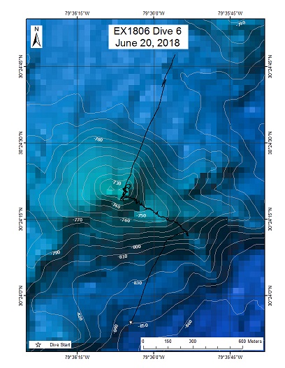
Stetson Mesa North; Blake Plateau (Million Mounds)
Overview
| Date: | June 20, 2018 |
| Max Depth: | 788 Meters |
| Bottom Time: | 5 Hours 16 Minutes 55 Seconds |
Purpose
This dive is part of a series that investigates the similarities and differences in community composition between deepwater habitats of the SE US continental margin. The general area was proposed by several scientists representing the SAFMC, NOAA DSCRTP, NOAA NCCOS, BOEM and the Deep Search team, as this region is an unexplored area with strong potential habitat suitability for deep sea corals. High resolution multibeam bathymetry shows many mound features at depths ranging 400 to 800 m throughout the Stetson Mesa. The dive site was selected for its steep slopes and overall vertical relief, in order to compare deeper areas with those at the mound's crest where current flow is greatest. This area also served as an excellent comparison to mounds explored to the south on the previous dive (Dive05). The area known as Stetson Mesa shows high habitat suitability for deep-sea corals in existing models (Kinlan et al. 2013). The region was first mapped during EX-14-03 and acquiring new information will inform biogeographic patterns in the region. Diving in the area provides important information to groundtruth these models.
Download & View Files
| Dive Summary Report (PDF - 1.89 MB) | View/Download | Requires Adobe Acrobat Reader to view the Dive Summary Report |
| Dive Track (KML - 66.8 KB) | View/Download | Requires Google Earth or equivalent client to view the Dive Track |
| ROV Ancillary Data (Zip - 4.19 MB) | Download | Link takes you to a public FTP server |
| ROV CTD/Sensor Data (Zip - 4.83 MB) | Download | Link takes you to a public FTP server |
| Camera Platform Sensor Data (Zip - 13.8 MB) | Download | Link takes you to a public FTP server |
| Low-Resolution Video Clips (Zip - 10 GB) | Download | Link takes you to a public FTP server |
| Underwater Still Images (Zip - 122 MB) | Download | Link takes you to a public FTP server |
| Dive Video Collection Self-Service Portal | Open | Link takes you to an online video discovery and access tool |
Richardson Ridge
Area
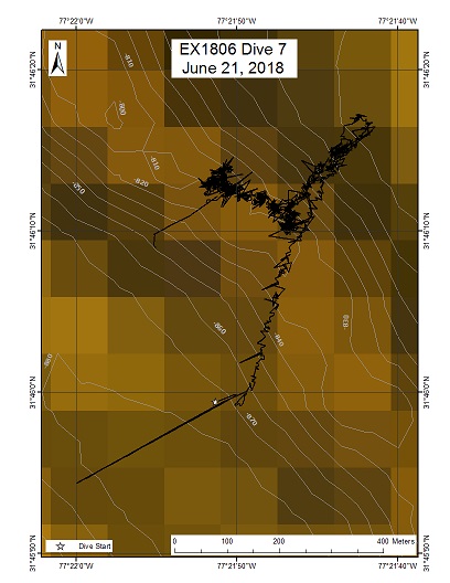
Richardson Ridge; Blake Plateau
Overview
| Date: | June 21, 2018 |
| Max Depth: | 873 Meters |
| Bottom Time: | 3 Hours 36 Minutes 40 Seconds |
Purpose
This dive site was selected for its knife-like ridge at the top of a steep 100 m relief slope that had gradients exceeding 30 degrees. Its position on the outer edge of the Gulf Stream's flow raised the question if it was of biogenic (i.e., coral rubble mound) or geologic (erosional scarp of rock layers) origin. The previous 2 dives explored mound features, revealing origin from massive accumulation of stoney coral skeletons. All 4 mounds explored hosted dense living coral and sponge communities. The Richardson Ridge was explored to compare biological communities on the ridge's slope (in the lee of the Gulf Stream) to those on the ridge crest, and to compare these areas with those of the previous 2 dives. This dive was part of a series that investigates the similarities and differences in community composition between deepwater habitats of the SE US continental margin. This site is within a large under-explored area of the Miami Stetson CHAPC and is a high priority region for the Deep Search project, with the primary objective to identify presence / absence of deepwater corals and benthic communities in areas with the potential for offshore development. This area was first mapped during EX-18-05. New information will inform biogeographic patterns in the region, critical for refining habitat prediction models. Diving in the area will provide important information to groundtruth these models.
Download & View Files
| Dive Summary Report (PDF - 1.73 MB) | View/Download | Requires Adobe Acrobat Reader to view the Dive Summary Report |
| Dive Track (KML - 67 KB) | View/Download | Requires Google Earth or equivalent client to view the Dive Track |
| ROV Ancillary Data (Zip - 3.75 MB) | Download | Link takes you to a public FTP server |
| ROV CTD/Sensor Data (Zip - 4.34 MB) | Download | Link takes you to a public FTP server |
| Camera Platform Sensor Data (Zip - 13.8 MB) | Download | Link takes you to a public FTP server |
| Low-Resolution Video Clips (Zip - 7.64 GB) | Download | Link takes you to a public FTP server |
| Underwater Still Images (Zip - 194 MB) | Download | Link takes you to a public FTP server |
| Dive Video Collection Self-Service Portal | Open | Link takes you to an online video discovery and access tool |
Richardson Scarp
Area
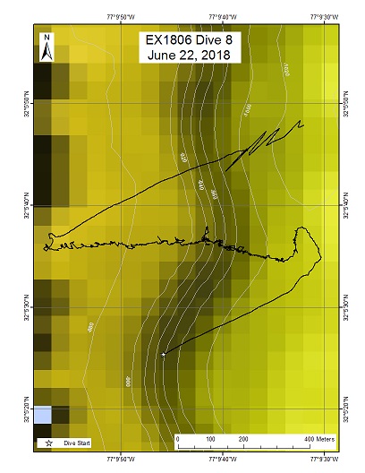
Richardson Scarp; Blake Plateau
Overview
| Date: | June 22, 2018 |
| Max Depth: | 1006 Meters |
| Bottom Time: | 6 Hours 29 Minutes 10 Seconds |
Purpose
This dive is part of a series that investigates the similarities and differences in community composition between deepwater habitats of the SE US continental margin. This site is within a large under-explored area of the Miami Stetson CHAPC and is a high priority region for the Deep Search project, with the primary objective to identify presence / absence of deepwater corals and benthic communities in areas with the potential for offshore development. This region was first mapped during EX-18-05. New information will inform biogeographic patterns in the region, critical for refining habitat prediction models. Diving in the area will provide important information to groundtruth these models.
Download & View Files
| Dive Summary Report (PDF - 2.04 MB) | View/Download | Requires Adobe Acrobat Reader to view the Dive Summary Report |
| Dive Track (KML - 67.5 KB) | View/Download | Requires Google Earth or equivalent client to view the Dive Track |
| ROV Ancillary Data (Zip - 4.94 MB) | Download | Link takes you to a public FTP server |
| ROV CTD/Sensor Data (Zip - 6.34 MB) | Download | Link takes you to a public FTP server |
| Camera Platform Sensor Data (Zip - 18.6 MB) | Download | Link takes you to a public FTP server |
| Low-Resolution Video Clips (Zip - 11.9 GB) | Download | Link takes you to a public FTP server |
| Underwater Still Images (Zip - 213 MB) | Download | Link takes you to a public FTP server |
| Dive Video Collection Self-Service Portal | Open | Link takes you to an online video discovery and access tool |
Blake Ridge Wreck
Area
Blake Ridge Wreck; North of the Blake Ridge, SE US Continental Margin
Overview
| Date: | June 23, 2018 |
| Max Depth: | n/a |
| Bottom Time: | n/a |
Purpose
A chance discovery by a Duke University and Woods Hole Oceanographic Institution mission in the submersible Alvin in 2015, revealed a wooden shipwreck. Named after its location on Blake Ridge, the wreck was briefly inspected, with the team in Alvin discovering scattered bottles, a ship's navigational octant, ceramics, and a pile of bricks. NOAA Ship Okeanos Explorer returned to better understand the site and to create a detailed, three-dimensional "map" of the wreck in collaboration with colleagues from the Bureau of Ocean Energy Management, other agencies, universities, the private sector, and the interested public.
Download & View Files
| Dive Summary Report (PDF - 942 KB) | View/Download | Requires Adobe Acrobat Reader to view the Dive Summary Report |
| Dive Video Collection Self-Service Portal | Open | Link takes you to an online video discovery and access tool |
Cape Fear
Area
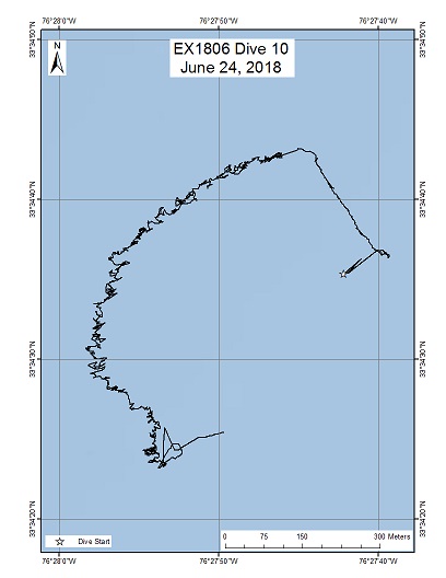
Cape Fear; Blake Plateau
Overview
| Date: | June 24, 2018 |
| Max Depth: | 454 Meters |
| Bottom Time: | 7 Hours 2 Minutes 43 Seconds |
Purpose
This dive is part of a series that investigates the similarities and differences in community composition between deepwater habitats of the SE US continental margin. This site is within Cape Fear Lophelia Banks Deepwater MPA. The general area was proposed by the Deep Search team, to identify presence / absence of deepwater corals and benthic communities in areas identified as having oil and gas potential in the Atlantic. Also, the Deep Sea Research and Technology Program and the NOAA Ocean Acidification Program will use information from this dive for future cruises when they will be sampling a number of locations in this area with the objective of fully constraining the carbonate chemistry of the area. Obtaining seafloor video footage at the same area could improve our understanding of the relationship between deep coral communities and carbonate chemistry. This region was first mapped during a MPA cruise aboard the NOAA Ship Nancy Foster in 2007 (NF-07-02) and new information will inform biogeographic patterns in the region. Diving in the area will provide important information to groundtruth these models.
Download & View Files
| Dive Summary Report (PDF - 2.53 MB) | View/Download | Requires Adobe Acrobat Reader to view the Dive Summary Report |
| Dive Track (KML - 66.8 KB) | View/Download | Requires Google Earth or equivalent client to view the Dive Track |
| ROV Ancillary Data (Zip - 5.4 MB) | Download | Link takes you to a public FTP server |
| ROV CTD/Sensor Data (Zip - 5.77 MB) | Download | Link takes you to a public FTP server |
| Camera Platform Sensor Data (Zip - 16.9 MB) | Download | Link takes you to a public FTP server |
| Low-Resolution Video Clips (Zip - 11.8 GB) | Download | Link takes you to a public FTP server |
| Underwater Still Images (Zip - 355 MB) | Download | Link takes you to a public FTP server |
| Dive Video Collection Self-Service Portal | Open | Link takes you to an online video discovery and access tool |
South of Pamlico Canyon
Area
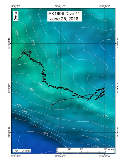
South of Pamlico Canyon; North Carolina Canyons
Overview
| Date: | June 25, 2018 |
| Max Depth: | 1716 Meters |
| Bottom Time: | 6 Hours 2 Minutes 42 Seconds |
Purpose
This dive is part of a series that investigates the similarities and differences in community composition between deepwater habitats of the SE US continental margin. Submarine canyon sites in the past have been shown to be deep sea coral habitats, particularly in areas of rock/hard-bottom exposure. This site was proposed by Deep Search to represent canyon features that have yet to be explored in detail. The autonomous vehicle Sentry has surveyed a handful of locations in the canyons off North Carolina, however visual information about the presence and ID of corals and other benthic fauna have not been possible. An ROV/HOV is required to visually examine these rugged, high profile features. This region was first mapped during a MPA cruise aboard the NOAA Ship Nancy Foster in 2007 (NF-07-02) and new information will inform biogeographic patterns in the region. Diving in the area will provide important information to groundtruth these models.
Download & View Files
| Dive Summary Report (PDF - 2.02 MB) | View/Download | Requires Adobe Acrobat Reader to view the Dive Summary Report |
| Dive Track (KML - 67.8 KB) | View/Download | Requires Google Earth or equivalent client to view the Dive Track |
| ROV Ancillary Data (Zip - 4.95 MB) | Download | Link takes you to a public FTP server |
| ROV CTD/Sensor Data (Zip - 6.19 MB) | Download | Link takes you to a public FTP server |
| Camera Platform Sensor Data (Zip - 17.8 MB) | Download | Link takes you to a public FTP server |
| Low-Resolution Video Clips (Zip - 11.4 GB) | Download | Link takes you to a public FTP server |
| Underwater Still Images (Zip - 208 MB) | Download | Link takes you to a public FTP server |
| Dive Video Collection Self-Service Portal | Open | Link takes you to an online video discovery and access tool |
Inter-Canyon Ridge
Area
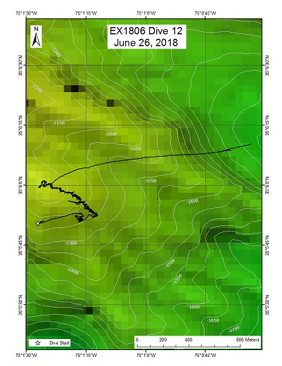
Inter-Canyon Ridge; North Carolina Canyons
Overview
| Date: | June 26, 2018 |
| Max Depth: | 1269 Meters |
| Bottom Time: | 3 Hours 54 Minutes 27 Seconds |
Purpose
This dive is part of a series that investigates the similarities and differences in community composition between deepwater habitats of the SE US continental margin. Submarine canyon sites in the past have been shown to be deep sea coral habitats, particularly in areas of rock/hard-bottom exposure. This site was proposed by Deep Search to represent canyon features that have yet to be explored in detail. The autonomous vehicle Sentry has surveyed a handful of locations in the canyons off North Carolina, however visual information about the presence and ID of corals and other benthic fauna have not been possible. An ROV/HOV is required to visually examine these rugged, high profile features. This region was first mapped during a MPA cruise aboard the NOAA Ship Nancy Foster in 2007 (NF-07-02) and new information will inform biogeographic patterns in the region. Diving in the area will provide important information to groundtruth habitat suitability models.
Download & View Files
| Dive Summary Report (PDF - 1.81 MB) | View/Download | Requires Adobe Acrobat Reader to view the Dive Summary Report |
| Dive Track (KML - 66.4 KB) | View/Download | Requires Google Earth or equivalent client to view the Dive Track |
| ROV Ancillary Data (Zip - 3.8 MB) | Download | Link takes you to a public FTP server |
| ROV CTD/Sensor Data (Zip - 4.26 MB) | Download | Link takes you to a public FTP server |
| Camera Platform Sensor Data (Zip - 12.2 MB) | Download | Link takes you to a public FTP server |
| Low-Resolution Video Clips (Zip - 7.97 GB) | Download | Link takes you to a public FTP server |
| Underwater Still Images (Zip - 100 MB) | Download | Link takes you to a public FTP server |
| Dive Video Collection Self-Service Portal | Open | Link takes you to an online video discovery and access tool |
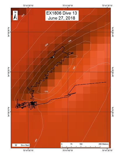
"Big Dipper" Anomaly / Wreckless Scarp
Area
"Big Dipper" Anomaly / Wreckless Scarp; Offshore North Carolina
Overview
| Date: | June 27, 2018 |
| Max Depth: | 376 Meters |
| Bottom Time: | 7 Hours 0 Minutes 51 Seconds |
Purpose
This dive was originally planned to investigate a large and long scour mark on the seafloor identified in MB and backscatter images possibly caused by a shipwreck. Similar scour marks are associated with shipwrecks on the OCS off North Carolina caused primarily by the strong current of the Gulf Stream. The scour is near the reported location of a ship sunk in World War Two.
Download & View Files
| Dive Summary Report (PDF - 2.16 MB) | View/Download | Requires Adobe Acrobat Reader to view the Dive Summary Report |
| Dive Track (KML - 67.2 KB) | View/Download | Requires Google Earth or equivalent client to view the Dive Track |
| ROV Ancillary Data (Zip - 4.94 MB) | Download | Link takes you to a public FTP server |
| ROV CTD/Sensor Data (Zip - 6.13 MB) | Download | Link takes you to a public FTP server |
| Camera Platform Sensor Data (Zip - 18.2 MB) | Download | Link takes you to a public FTP server |
| Low-Resolution Video Clips (Zip - 11.3 GB) | Download | Link takes you to a public FTP server |
| Underwater Still Images (Zip - 171 MB) | Download | Link takes you to a public FTP server |
| Dive Video Collection Self-Service Portal | Open | Link takes you to an online video discovery and access tool |
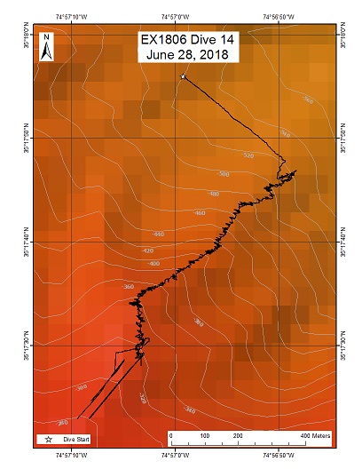
Hatteras Canyon
Area
Hatteras Canyon; Southeast U.S. Continental Margin - North Carolina Canyons
Overview
| Date: | June 28, 2018 |
| Max Depth: | 510 Meters |
| Bottom Time: | 7 Hours 17 Minutes 54 Seconds |
Purpose
This dive was part of a series that investigates the similarities and differences in community composition between deepwater habitats of the SE US continental margin. Submarine canyon sites in the past have been shown to be deep sea coral habitats, particularly in areas of rock/hard-bottom exposure. This site was proposed by Deep Search to represent canyon features that have yet to be explored in detail. The autonomous vehicle Sentry has surveyed a handful of locations in the canyons off North Carolina, however visual information about the presence and ID of corals and other benthic fauna have not been possible. An ROV/HOV is required to visually examine these rugged, high profile features.
Download & View Files
| Dive Summary Report (PDF - 1.77 MB) | View/Download | Requires Adobe Acrobat Reader to view the Dive Summary Report |
| Dive Track (KML - 66.9 KB) | View/Download | Requires Google Earth or equivalent client to view the Dive Track |
| ROV Ancillary Data (Zip - 4.64 MB) | Download | Link takes you to a public FTP server |
| ROV CTD/Sensor Data (Zip - 6.56 MB) | Download | Link takes you to a public FTP server |
| Camera Platform Sensor Data (Zip - 18.1 MB) | Download | Link takes you to a public FTP server |
| Low-Resolution Video Clips (Zip - 11.3 GB) | Download | Link takes you to a public FTP server |
| Underwater Still Images (Zip - 186 MB) | Download | Link takes you to a public FTP server |
| Dive Video Collection Self-Service Portal | Open | Link takes you to an online video discovery and access tool |
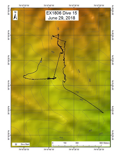
Keller Canyon
Area
Keller Canyon; Southeast U.S. Continental Margin - North Carolina Canyons
Overview
| Date: | June 29, 2018 |
| Max Depth: | 728 Meters |
| Bottom Time: | 5 Hours 18 Minutes 2 Seconds |
Purpose
This dive was part of a series that will investigate the similarities and differences in community composition between deepwater habitats of the SE US continental margin. Submarine canyon sites in the past have been shown to be deep sea coral habitats, particularly in areas of rock/hard-bottom exposure. This site was proposed by Deep Search to represent canyon features that have yet to be explored in detail. The autonomous vehicle Sentry has surveyed a handful of locations in the canyons off North Carolina, however visual information about the presence and ID of corals and other benthic fauna have not been possible. An ROV/HOV is required to visually examine these rugged, high profile features.
Download & View Files
| Dive Summary Report (PDF - 2.04 MB) | View/Download | Requires Adobe Acrobat Reader to view the Dive Summary Report |
| Dive Track (KML - 67.2 KB) | View/Download | Requires Google Earth or equivalent client to view the Dive Track |
| ROV Ancillary Data (Zip - 5.74 MB) | Download | Link takes you to a public FTP server |
| ROV CTD/Sensor Data (Zip - 8.03 MB) | Download | Link takes you to a public FTP server |
| Camera Platform Sensor Data (Zip - 22 MB) | Download | Link takes you to a public FTP server |
| Low-Resolution Video Clips (Zip - 14.2 GB) | Download | Link takes you to a public FTP server |
| Underwater Still Images (Zip - 150 MB) | Download | Link takes you to a public FTP server |
| Dive Video Collection Self-Service Portal | Open | Link takes you to an online video discovery and access tool |
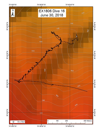
Pea Island
Area
Pea Island; Southeast U.S. Continental Margin - North Carolina Canyons
Overview
| Date: | June 30, 2018 |
| Max Depth: | 521 Meters |
| Bottom Time: | 6 Hours 58 Minutes 39 Seconds |
Purpose
Several hundred seep locations were discovered through multibeam mapping efforts that began in 2012. However, many have not been visually verified. One of the primary goals of the DEEP SEARCH project is to investigate the mid-Atlantic region for chemosynthetic environments in order to identify vulnerable communities that may be adversely influenced by energy exploration. The autonomous vehicle Sentry has surveyed a handful of locations in the canyons off North Carolina, however visual information about the presence of seeps is still necessary. An ROV/HOV is required to visually examine possible seeps along these rugged, high profile features.
Download & View Files
| Dive Summary Report (PDF - 2.2 MB) | View/Download | Requires Adobe Acrobat Reader to view the Dive Summary Report |
| Dive Track (KML - 68.1 KB) | View/Download | Requires Google Earth or equivalent client to view the Dive Track |
| ROV Ancillary Data (Zip - 5.04 MB) | Download | Link takes you to a public FTP server |
| ROV CTD/Sensor Data (Zip - 6.51 MB) | Download | Link takes you to a public FTP server |
| Camera Platform Sensor Data (Zip - 17.3 MB) | Download | Link takes you to a public FTP server |
| Low-Resolution Video Clips (Zip - 11.3 GB) | Download | Link takes you to a public FTP server |
| Underwater Still Images (Zip - 266 MB) | Download | Link takes you to a public FTP server |
| Dive Video Collection Self-Service Portal | Open | Link takes you to an online video discovery and access tool |
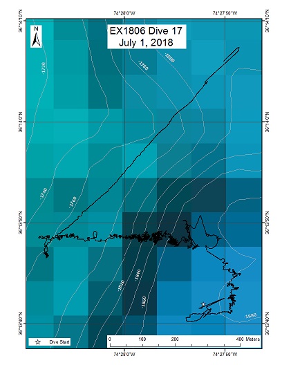
Currituck
Area
Currituck; Southeast U.S. Continental Margin
Overview
| Date: | July 01, 2018 |
| Max Depth: | 1881 Meters |
| Bottom Time: | 6 Hours 9 Minutes 45 Seconds |
Purpose
The Currituck Landslide is one of the largest submarine landslides on the US East Coast where a massive, partially intact segment of the continental slope detached and slid to depths exceeding 2000 m. Information about this landslide site is often used in tsunami hazard modeling. This dive explored and characterized unfailed sedimentary sections preserved in the landslide's lower headwall.
Download & View Files
| Dive Summary Report (PDF - 2.47 MB) | View/Download | Requires Adobe Acrobat Reader to view the Dive Summary Report |
| Dive Track (KML - 67.9 KB) | View/Download | Requires Google Earth or equivalent client to view the Dive Track |
| ROV Ancillary Data (Zip - 5.5 MB) | Download | Link takes you to a public FTP server |
| ROV CTD/Sensor Data (Zip - 5.91 MB) | Download | Link takes you to a public FTP server |
| Camera Platform Sensor Data (Zip - 17.3 MB) | Download | Link takes you to a public FTP server |
| Low-Resolution Video Clips (Zip - 12.3 GB) | Download | Link takes you to a public FTP server |
| Underwater Still Images (Zip - 264 MB) | Download | Link takes you to a public FTP server |
| Dive Video Collection Self-Service Portal | Open | Link takes you to an online video discovery and access tool |

