
Okeanos Explorer (EX2301): 2023 Shakedown + EXPRESS West Coast Exploration
Vessel: NOAA Ship Okeanos Explorer; Expedition Dates: April 13 - April 27, 2023
Project Principals: Thomas Morrow, NOAA/OAR/OER (Expedition Coordinator); Sam Candio, NOAA/OAR/OER (Mapping Lead)
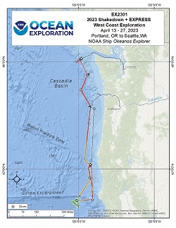
From April 13-27, 2023 (Portland, Oregon, to Seattle, Washington), NOAA Ocean Exploration conducted the 2023 Shakedown + EXPRESS West Coast Exploration expedition (EX2301), an ROV and Mapping expedition to a shakedown the remotely operated vehicle (ROV), video, telepresence, seafloor mapping, and sampling operations aboard NOAA Ship Okeanos Explorer, as well as explore deep waters off the west coast of the United States. Operations during this 15-day expedition included the completion of 9 successful remotely operated vehicle (ROV) dives, which were conducted in water depths ranging from 650 m to 3960 m for approximately 45:34 hours of bottom time and resulted in the collection of 92 samples.
Expedition Data and Resources
| Ship Navigation Data (ASCII) | Download | Use zip utility to open file |
| Ship SCS/Sensor Data (ASCII) | Download | Use zip utility to open file |
| Ship SCS/Sensor Data (NetCDF) | Open | NetCDF file format: Special software needed to read |
| Bulk Data Download | Download | Use zip utility to open file |
| Shipboard CTDs | Download | Use zip utility to open file |
| Mapping Products | Download | Use zip utility to open file |
Submersible Data and Resources
| Dive Track KMLs | Download | Use zip utility to open file |
| ROV Dive Event Logs | Open | Click to open link |
| Cruise Video Collection Self-Service Portal | Open | Click to open link |
| Specimens Collected During Dive Operations | Download | Click to open link |
| Submersible Navigation/Sensor Data (ASCII) | Download | Use zip utility to open file |
Collected Specimen Repositories
| Smithsonian National Museum of Natural History (Biological Samples) | Open | Click to visit repository website |
| Oregon State University's Marine Geology Repository | Open | Click to visit repository website |
Educational Resources
| Education Materials Collection | Open | Click to open Education Materials |
Links to Archived Data and Resources
| Multibeam Archive Collection | Get Data | Click to Access Archive |
| Water Column Sonar Archive Collection | Get Data | Click to Access Archive |
| Single-beam and Sub-bottom Data Archive Collection | Get Data | Click to Access Archive |
| Physical, Chemical, and Biological Archive Collection | Get Data | Click to Access Archive |
| Expedition Metadata | Open | Click to view Metadata in xml format |
Tillamook Flats (Shakedown)
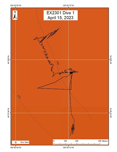
Area
Tillamook Flats (Shakedown); Relatively flat bottom, likely sedimented area around 600m
Overview
| Date: | April 15, 2023 |
| Max Depth: | 657.4 Meters |
| Bottom Time: | 7 Hours 23 Minutes 27 Seconds |
Purpose
ROV Engineering Shakedown
Download & View Files
| Dive Summary Report (PDF - 1.25 MB) | View/Download | Requires Adobe Acrobat Reader to view the Dive Summary Report |
| Dive Track (KML - 78 KB) | View/Download | Requires Google Earth or equivalent client to view the Dive Track |
| ROV Ancillary Data (Zip - 17.1 MB) | Download | Link takes you to a public FTP server |
| ROV CTD/Sensor Data (Zip - 60 MB) | Download | Link takes you to a public FTP server |
| Camera Platform Sensor Data (Zip - 60.3 MB) | Download | Link takes you to a public FTP server |
| Low-Resolution Video Clips (Zip - 13.5 GB) | Download | Link takes you to a public FTP server |
| Underwater Still Images (Zip - 56.7 MB) | Download | Link takes you to a public FTP server |
| Dive Video Collection Self-Service Portal | Open | Link takes you to an online video discovery and access tool |
Mendocino Flats (Shakedown)
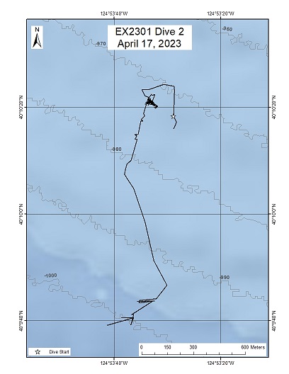
Area
Mendocino Flats (Shakedown); Relatively flat bottom, likely sedimented area around 1000m
Overview
| Date: | April 17, 2023 |
| Max Depth: | 971.3 Meters |
| Bottom Time: | 2 Hours 28 Minutes 43 Seconds |
Purpose
ROV Engineering Shakedown
Download & View Files
| Dive Summary Report (PDF - 1.06 MB) | View/Download | Requires Adobe Acrobat Reader to view the Dive Summary Report |
| Dive Track (KML - 76 KB) | View/Download | Requires Google Earth or equivalent client to view the Dive Track |
| ROV Ancillary Data (Zip - 9.97 MB) | Download | Link takes you to a public FTP server |
| ROV CTD/Sensor Data (Zip - 37.4 MB) | Download | Link takes you to a public FTP server |
| Camera Platform Sensor Data (Zip - 36.9 MB) | Download | Link takes you to a public FTP server |
| Low-Resolution Video Clips (Zip - 8.03 GB) | Download | Link takes you to a public FTP server |
| Underwater Still Images (Zip - 28.6 MB) | Download | Link takes you to a public FTP server |
| Dive Video Collection Self-Service Portal | Open | Link takes you to an online video discovery and access tool |
Deep Mendocino Flats (Shakedown)
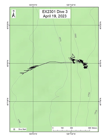
Area
Deep Mendocino Flats (Shakedown); Relatively flat bottom, likely sedimented area around 4000m
Overview
| Date: | April 19, 2023 |
| Max Depth: | 3955.8 Meters |
| Bottom Time: | 3 Hours 7 Minutes 33 Seconds |
Purpose
ROV Engineering Shakedown
Download & View Files
| Dive Summary Report (PDF - 2.48 MB) | View/Download | Requires Adobe Acrobat Reader to view the Dive Summary Report |
| Dive Track (KML - 80 KB) | View/Download | Requires Google Earth or equivalent client to view the Dive Track |
| ROV Ancillary Data (Zip - 17.4 MB) | Download | Link takes you to a public FTP server |
| ROV CTD/Sensor Data (Zip - 68.4 MB) | Download | Link takes you to a public FTP server |
| Camera Platform Sensor Data (Zip - 65.7 MB) | Download | Link takes you to a public FTP server |
| Low-Resolution Video Clips (Zip - 14.1 GB) | Download | Link takes you to a public FTP server |
| Underwater Still Images (Zip - 56.3 MB) | Download | Link takes you to a public FTP server |
| Dive Video Collection Self-Service Portal | Open | Link takes you to an online video discovery and access tool |
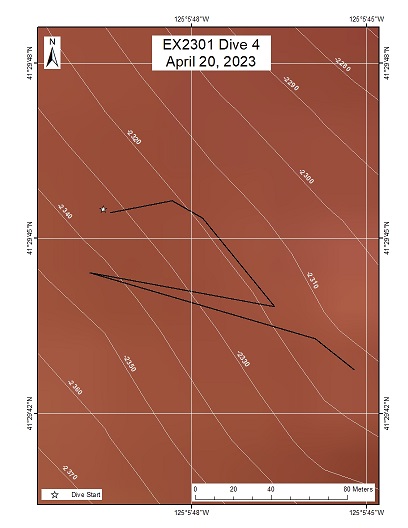
Trinidad Slump (Shakedown)
Area
Trinidad Slump (Shakedown); Sloped submarine slump deposit with bottom around 2330m depth
Overview
| Date: | April 20, 2023 |
| Max Depth: | 2424 Meters |
| Bottom Time: | 4 Hours 57 Minutes 16 Seconds |
Purpose
ROV Engineering Shakedown
Download & View Files
| Dive Summary Report (PDF - 2.65 MB) | View/Download | Requires Adobe Acrobat Reader to view the Dive Summary Report |
| Dive Track (KML - 78 KB) | View/Download | Requires Google Earth or equivalent client to view the Dive Track |
| ROV Ancillary Data (Zip - 16.7 MB) | Download | Link takes you to a public FTP server |
| ROV CTD/Sensor Data (Zip - 49.6 MB) | Download | Link takes you to a public FTP server |
| Camera Platform Sensor Data (Zip - 54.7 MB) | Download | Link takes you to a public FTP server |
| Low-Resolution Video Clips (Zip - 14.1 GB) | Download | Link takes you to a public FTP server |
| Underwater Still Images (Zip - 76.7 MB) | Download | Link takes you to a public FTP server |
| Dive Video Collection Self-Service Portal | Open | Link takes you to an online video discovery and access tool |
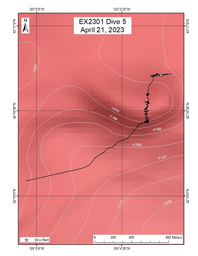
Horseshoe (Shakedown)
Area
Horseshoe (Shakedown); Continental slope with bottom around 1880m depth
Overview
| Date: | April 21, 2023 |
| Max Depth: | 1817 Meters |
| Bottom Time: | 3 Hours 17 Minutes 40 Seconds |
Purpose
ROV Engineering Shakedown
Download & View Files
| Dive Summary Report (PDF - 972 KB) | View/Download | Requires Adobe Acrobat Reader to view the Dive Summary Report |
| Dive Track (KML - 77 KB) | View/Download | Requires Google Earth or equivalent client to view the Dive Track |
| ROV Ancillary Data (Zip - 10.2 MB) | Download | Link takes you to a public FTP server |
| ROV CTD/Sensor Data (Zip - 29.4 MB) | Download | Link takes you to a public FTP server |
| Camera Platform Sensor Data (Zip - 29.4 MB) | Download | Link takes you to a public FTP server |
| Low-Resolution Video Clips (Zip - 6.6 GB) | Download | Link takes you to a public FTP server |
| Underwater Still Images (Zip - 30.7 MB) | Download | Link takes you to a public FTP server |
| Dive Video Collection Self-Service Portal | Open | Link takes you to an online video discovery and access tool |
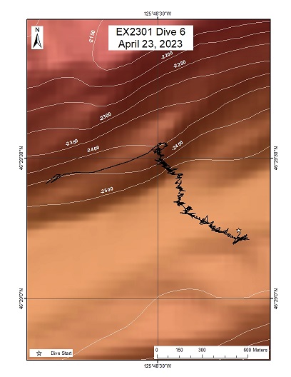
North Astoria Canyon (Shakedown)
Area
North Astoria Canyon (Shakedown); Sloped region along Cascadia deformation front with max depth of 2530m
Overview
| Date: | April 23, 2023 |
| Max Depth: | 2531.7 Meters |
| Bottom Time: | 5 Hours 4 Minutes 2 Seconds |
Purpose
ROV Engineering Shakedown
Download & View Files
| Dive Summary Report (PDF - 6.38 MB) | View/Download | Requires Adobe Acrobat Reader to view the Dive Summary Report |
| Dive Track (KML - 78 KB) | View/Download | Requires Google Earth or equivalent client to view the Dive Track |
| ROV Ancillary Data (Zip - 17 MB) | Download | Link takes you to a public FTP server |
| ROV CTD/Sensor Data (Zip - 59.1 MB) | Download | Link takes you to a public FTP server |
| Camera Platform Sensor Data (Zip - 27.4 MB) | Download | Link takes you to a public FTP server |
| Low-Resolution Video Clips (Zip - 13.6 GB) | Download | Link takes you to a public FTP server |
| Underwater Still Images (Zip - 103 MB) | Download | Link takes you to a public FTP server |
| Dive Video Collection Self-Service Portal | Open | Link takes you to an online video discovery and access tool |
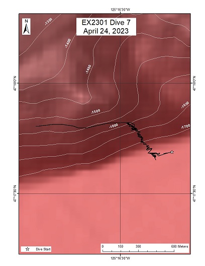
Quinault Canyon
Area
Quinault Canyon; Sloped region within canyon with max depth of 1711m
Overview
| Date: | April 24, 2023 |
| Max Depth: | 1718.5 Meters |
| Bottom Time: | 5 Hours 41 Minutes 1 Seconds |
Purpose
ROV Engineering Shakedown
Download & View Files
| Dive Summary Report (PDF - 9.01 MB) | View/Download | Requires Adobe Acrobat Reader to view the Dive Summary Report |
| Dive Track (KML - 79 KB) | View/Download | Requires Google Earth or equivalent client to view the Dive Track |
| ROV Ancillary Data (Zip - 17.1 MB) | Download | Link takes you to a public FTP server |
| ROV CTD/Sensor Data (Zip - 61.7 MB) | Download | Link takes you to a public FTP server |
| Camera Platform Sensor Data (Zip - 59.7 MB) | Download | Link takes you to a public FTP server |
| Low-Resolution Video Clips (Zip - 14.1 GB) | Download | Link takes you to a public FTP server |
| Underwater Still Images (Zip - 146 MB) | Download | Link takes you to a public FTP server |
| Dive Video Collection Self-Service Portal | Open | Link takes you to an online video discovery and access tool |
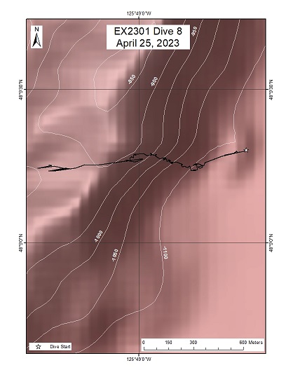
Nitinat Canyon
Area
Nitinat Canyon; Sloped canyon wall with max depth of 1121m
Overview
| Date: | April 25, 2023 |
| Max Depth: | 1104.8 Meters |
| Bottom Time: | 6 Hours 36 Minutes 13 Seconds |
Purpose
ROV Engineering Shakedown
Download & View Files
| Dive Summary Report (PDF - 6.36 MB) | View/Download | Requires Adobe Acrobat Reader to view the Dive Summary Report |
| Dive Track (KML - 79KB) | View/Download | Requires Google Earth or equivalent client to view the Dive Track |
| ROV Ancillary Data (Zip - 17.4 MB) | Download | Link takes you to a public FTP server |
| ROV CTD/Sensor Data (Zip - 69.2 MB) | Download | Link takes you to a public FTP server |
| Camera Platform Sensor Data (Zip - 67.1 MB) | Download | Link takes you to a public FTP server |
| Low-Resolution Video Clips (Zip - 13.9 GB) | Download | Link takes you to a public FTP server |
| Underwater Still Images (Zip - 214 MB) | Download | Link takes you to a public FTP server |
| Dive Video Collection Self-Service Portal | Open | Link takes you to an online video discovery and access tool |
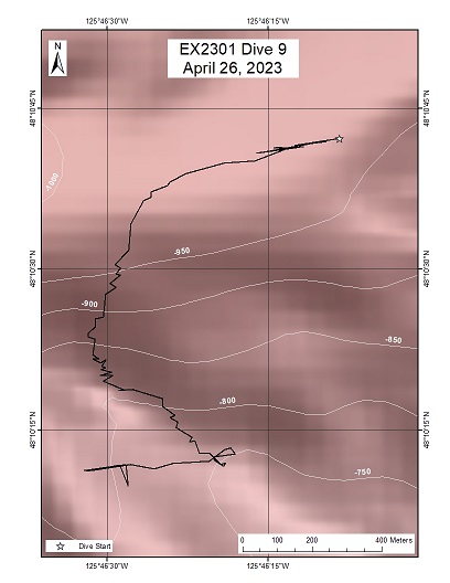
Nitinat Canyon 2
Area
Nitinat Canyon 2; Sloped canyon wall with max depth of 1121m
Overview
| Date: | April 26, 2023 |
| Max Depth: | 989.6 Meters |
| Bottom Time: | 6 Hours 58 Minutes 18 Seconds |
Purpose
ROV Engineering Shakedown
Download & View Files
| Dive Summary Report (PDF - 4.86 MB) | View/Download | Requires Adobe Acrobat Reader to view the Dive Summary Report |
| Dive Track (KML - 79 KB) | View/Download | Requires Google Earth or equivalent client to view the Dive Track |
| ROV Ancillary Data (Zip - 17.2 MB) | Download | Link takes you to a public FTP server |
| ROV CTD/Sensor Data (Zip - 57.9 MB) | Download | Link takes you to a public FTP server |
| Camera Platform Sensor Data (Zip - 62.6 MB) | Download | Link takes you to a public FTP server |
| Low-Resolution Video Clips (Zip - 13.7 GB) | Download | Link takes you to a public FTP server |
| Underwater Still Images (Zip - 209 MB) | Download | Link takes you to a public FTP server |
| Dive Video Collection Self-Service Portal | Open | Link takes you to an online video discovery and access tool |

