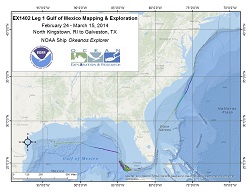
Okeanos Explorer (EX1402L1): Gulf of Mexico Exploration and Mapping
Vessel: NOAA Ship Okeanos Explorer; Expedition Dates: February 24 - March 15, 2014
Project Principals: Elizabeth Lobecker, NOAA/OAR/OER (Expedition Coordinator and Mapping Lead)

Leg 1 of EX1402: Exploration of the Gulf of Mexico mission is a deep water exploratory mapping expedition along a transit path south along the edge of the Atlantic continental shelf south of Rhode Island, to top priority targets in U.S. Federal waters offshore of Florida in both the Atlantic Ocean and the Gulf of Mexico, and to the port of Galveston, Texas. EK60 single beam sonar calibration and testing will be completed.
Expedition Data and Resources
| Mapping Summary Report (PDF - 2.12 MB) | Open | Click to open link |
| Mapping Products | Download | Use zip utility to open file |
| Shipboard CTDs | Download | Use zip utility to open file |
| Ship Navigation Data (ASCII) | Download | Use zip utility to open file |
| Ship SCS/Sensor Data (ASCII) | Download | Use zip utility to open file |
| Ship SCS/Sensor Data (NetCDF) | Open | NetCDF file format: Special software needed to read |
Educational Resources
| Expedition Education Module | Open | Click to open Education Module |
| Lesson Plans (K-12) | Open | Click to open Lesson Plans |
| Education Materials Collection | Open | Click to open Education Materials |
Publication Resources
| NOAA Central Library OER Bibliography | Open | Click to open OER Bibliography |
Links to Archived Data and Resources
| Multibeam Archive Collection | Get Data | Click to Access Archive |
| Water Column Sonar Archive Collection | Get Data | Click to Access Archive |
| Trackline Data (Single-beam and Sub-bottom) | Get Data | Click to Access Archive |
| Physical, Chemical, and Biological Archive Collection | Get Data | Click to Access Archive |
| Collection of Documents | Get Data | Click to Access Archive |
| Expedition Metadata | Open | Click to view Metadata in xml format |

