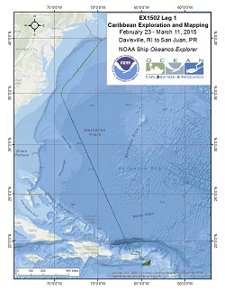
Okeanos Explorer (EX1502L1): Caribbean Exploration and Mapping I
Vessel: NOAA Ship Okeanos Explorer; Expedition Dates: February 23 - March 11, 2015
Project Principals: Lindsay McKenna, NOAA/OAR/OER (Expedition Coordinator and Mapping Lead)

EX1502L1 is a transit and mapping cruise from Rhode Island to Puerto Rico. In addition to seafloor mapping by the Okeanos Explorer (EX), three surveys of opportunity will be hosted by the EX during this cruise: NAVOCEANO gliders deployment on shelf break near British Virgin Islands, exploration of the Muertos Trough and the Puerto Rico Trench via untethered free vehicles, and the NASA Maritime Aerosol Network collection of marine aerosol observations using sun photometers.
Expedition Data and Resources
| Mapping Summary Report (PDF - .002 MB) | Open | Click to open link |
| Mapping Products | Download | Use zip utility to open file |
| Shipboard CTDs | Download | Use zip utility to open file |
| Ship Navigation Data (ASCII) | Download | Use zip utility to open file |
| Ship SCS/Sensor Data (ASCII) | Download | Use zip utility to open file |
| Ship SCS/Sensor Data (NetCDF) | Open | NetCDF file format: Special software needed to read |
Educational Resources
| Expedition Education Module | Open | Click to open Education Module |
| Lesson Plans (K-12) | Open | Click to open Lesson Plans |
| Education Materials Collection | Open | Click to open Education Materials |
Publication Resources
| NOAA Central Library OER Bibliography | Open | Click to open OER Bibliography |
Links to Archived Data and Resources
| Multibeam Archive Collection | Get Data | Click to Access Archive |
| Water Column Sonar Archive Collection | Get Data | Click to Access Archive |
| Trackline Data (Single-beam and Sub-bottom) | Get Data | Click to Access Archive |
| Physical, Chemical, and Biological Archive Collection | Get Data | Click to Access Archive |
| Collection of Documents | Get Data | Click to Access Archive |
| Expedition Metadata | Open | Click to view Metadata in xml format |

