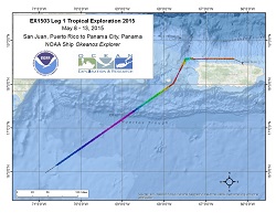
Okeanos Explorer (EX1503L1): Tropical Exploration 2015 (Mapping)
Vessel: NOAA Ship Okeanos Explorer; Expedition Dates: May 8 - 13, 2015
Project Principals: Lindsay McKenna, NOAA/OAR/OER (Expedition Coordinator and Mapping Lead)

After her latest expedition in the Caribbean, Okeanos Explorer left port in San Juan, Puerto Rico and transited to Panama to position itself for its ultimate destination for the remainder of the FY15 field season and the FY16 and FY17 field seasons working in the northwest Hawaiian Islands for the Campaign to Address Pacific Science, Technology, and Ocean NEeds (CAPSTONE) expedition.
Expedition Data and Resources
| Mapping Summary Report (PDF - 3.06 MB) | Open | Click to open link |
| Mapping Products | Download | Use zip utility to open file |
| Shipboard CTDs | Download | Use zip utility to open file |
| Ship Navigation Data (ASCII) | Download | Use zip utility to open file |
| Ship SCS/Sensor Data (ASCII) | Download | Use zip utility to open file |
| Ship SCS/Sensor Data (NetCDF) | Open | NetCDF file format: Special software needed to read |
Educational Resources
| Expedition Education Module | Open | Click to open Education Module |
| Lesson Plans (K-12) | Open | Click to open Lesson Plans |
| Education Materials Collection | Open | Click to open Education Materials |
Publication Resources
| NOAA Central Library OER Bibliography | Open | Click to open OER Bibliography |
Links to Archived Data and Resources
| Multibeam Archive Collection | Get Data | Click to Access Archive |
| Water Column Sonar Archive Collection | Get Data | Click to Access Archive |
| Trackline Data (Single-beam and Sub-bottom) | Get Data | Click to Access Archive |
| Physical, Chemical, and Biological Archive Collection | Get Data | Click to Access Archive |
| Collection of Documents | Get Data | Click to Access Archive |
| Expedition Metadata | Open | Click to view Metadata in xml format |

