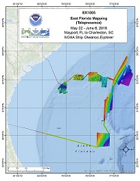
Okeanos Explorer (EX1805): East Florida Telemapping (Mapping)
Vessel: NOAA Ship Okeanos Explorer; Expedition Dates: May 22, 2018 to June 06, 2018
Ports: Mayport, FL to Charleston, SC
Project Principals: Elizabeth Lobecker, NOAA/OAR/OER (Expedition Coordinator and Mapping Lead)

The screens of the mapping acquisition systems (EM 302, EK 60, SBP etc.) will be broadcast 24 hours per day, and will be monitored by both onboard and onshore mapping scientists. Mapping computers will sometimes be controlled by the onshore team. The raw data from all sonars will be transmitted to shore and further processing will be completed on shore. Automated bathymetric gridding will occur on the ship in order for the onboard team to monitor and ensure adequate seabed coverage.
Expedition Data and Resources
| Mapping Summary Report (PDF - 2.55 MB) | Open | Click to open link |
| Mapping Products | Download | Use zip utility to open file |
| Shipboard CTDs | Download | Use zip utility to open file |
| Ship Navigation Data (ASCII) | Download | Use zip utility to open file |
| Ship SCS/Sensor Data (ASCII) | Download | Use zip utility to open file |
| Ship SCS/Sensor Data (NetCDF) | Open | NetCDF file format: Special software needed to read |
Educational Resources
| Education Materials Collection | Open | Click to open Education Materials |
Publication Resources
| NOAA Central Library OER Bibliography | Open | Click to open OER Bibliography |
Links to Archived Data and Resources
| Multibeam Archive Collection | Get Data | Click to Access Archive |
| Water Column Sonar Archive Collection | Get Data | Click to Access Archive |
| Trackline Data (Single-beam and Sub-bottom) | Get Data | Click to Access Archive |
| Physical, Chemical, and Biological Archive Collection | Get Data | Click to Access Archive |
| Expedition Metadata | Open | Click to view Metadata in xml format |

