
Okeanos Explorer (EX1304L2): Northeast U.S. Canyons Exploration
Vessel: NOAA Ship Okeanos Explorer; Expedition Dates: July 31 - August 17, 2013
Project Principals: Brian Kennedy, NOAA/OAR/OER (Expedition Coordinator); Adam Skarke, NOAA/OAR/OER (Mapping Lead)
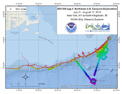
From July 31 to August 16, the Northeast U.S. Canyons 2013 Expedition continued exploration of the geomorphology and benthic ecology of deep-sea canyons and Mytilus Seamount along the Northeast US Atlantic margin. During Leg 2 of this mission, ROV Deep Discoverer (D2) surveyed the area extending between Alvin and Block canyons in the west and Heezen Canyon (eastern limit of the EEZ) to the east. Fifteen dives, ranging in depth from 490 to 3300 m were completed at five named canyons (Nygren, Heezen, Oceanographer, Lydonia, and Welker), one minor canyon (unnamed near Shallop Canyon), two intercanyon sites, two USGS geohazards targets, and Mytilus Seamount.
Expedition Data and Resources
| Ship Navigation Data (ASCII) | Download | Use zip utility to open file |
| Ship SCS/Sensor Data (ASCII) | Download | Use zip utility to open file |
| Ship SCS/Sensor Data (NetCDF) | Open | NetCDF file format: Special software needed to read |
| Shipboard CTDs | Download | Use zip utility to open file |
| Mapping Products | Download | Use zip utility to open file |
| GIS Products | Download | Use zip utility to open file |
Submersible Data and Resources
| Dive Track KMLs | Download | Use zip utility to open file |
| Event Logs | Open | Click to open link |
| Cruise Video Collection Self-Service Portal | Open | Click to open link |
| Submersible Navigation/Sensor Data (ASCII) | Download | Use zip utility to open file |
Educational Resources
| Expedition Education Module | Open | Click to open Education Module |
| Lesson Plans (K-12) | Open | Click to open Lesson Plans |
| Education Materials Collection | Open | Click to open Education Materials |
Links to Archived Data and Resources
| Multibeam Archive Collection | Get Data | Click to Access Archive |
| Water Column Sonar Archive Collection | Get Data | Click to Access Archive |
| Singlebeam and Subbottom Archive Collection | Get Data | Click to Access Archive |
| Oceanographic Data Collection | Get Data | Click to Access Archive |
| Collection of Documents | Get Data | Click to Access Archive |
| Expedition Metadata | Open | Click to view Metadata in xml format |
USGS Hazard 1
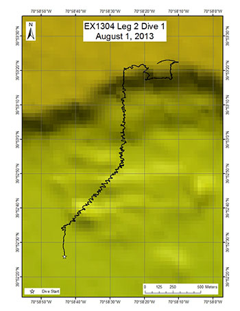
Area
USGS Hazard 1; Northeast U.S. Canyons
Overview
| Date: | August 01, 2013 |
| Max Depth: | 784.1 Meters |
| Bottom Time: | 7 Hours 1 Minutes 29 Seconds |
Purpose
The purpose of this proposed dive is to investigate small, potentially recent, landslide debris deposits and scarps within a larger landslide scar on the upper continental slope. The scientific rationale for this site is: 1. To determine if these small landslide debris features are relatively young and if they pose a hazard in terms of tsunami generation. 2. To evaluate the long term stability of landslide scars and test hypotheses about their evolution. 3. To attempt to develop a means of using biologic activity on the scarps and deposits as a means of determining relative ages of the features and the response of bottom communities to catastrophic events.
Download & View Files
| Dive Summary Report (PDF - 663 KB) | View/Download | Requires Adobe Acrobat Reader to view the Dive Summary Report |
| Dive Track (KML - 227 KB) | View/Download | Requires Google Earth or equivalent client to view the Dive Track |
| ROV Ancillary Data (Zip - 45.3 MB) | Download | Link takes you to a public FTP server |
| Camera Platform Sensor Data (Zip - 3.99 MB) | Download | Link takes you to a public FTP server |
| Low-Resolution Video Clips (Zip - 3.4 GB) | Download | Link takes you to a public FTP server |
| Underwater Still Images (Zip - 336 MB) | Download | Link takes you to a public FTP server |
| Dive Video Collection Self-Service Portal | Open | Link takes you to an online video discovery and access tool |
Minor Canyon near Shallop Canyon

Area
Minor Canyon near Shallop Canyon; Northeast U.S. Canyons
Overview
| Date: | August 02, 2013 |
| Max Depth: | 1139.8 Meters |
| Bottom Time: | 5 Hours 34 Minutes 25 Seconds |
Purpose
The purpose of the dive was to: 1. Characterize the submarine canyon geomorphology and benthic habitats, including possible coral and sponge communities in a minor canyon near Shallop Canyon. 2. Groundtruth a model of predicted deep-sea coral occurrence.
Download & View Files
| Dive Summary Report (PDF - 966 KB) | View/Download | Requires Adobe Acrobat Reader to view the Dive Summary Report |
| Dive Track (KML - 176 KB) | View/Download | Requires Google Earth or equivalent client to view the Dive Track |
| ROV Ancillary Data (Zip - 43.3 MB) | Download | Link takes you to a public FTP server |
| Camera Platform Sensor Data (Zip - 3.9 MB) | Download | Link takes you to a public FTP server |
| Low-Resolution Video Clips (Zip - 2.9 GB) | Download | Link takes you to a public FTP server |
| Underwater Still Images (Zip - 256 MB) | Download | Link takes you to a public FTP server |
| Dive Video Collection Self-Service Portal | Open | Link takes you to an online video discovery and access tool |
Oceanographer Canyon 1
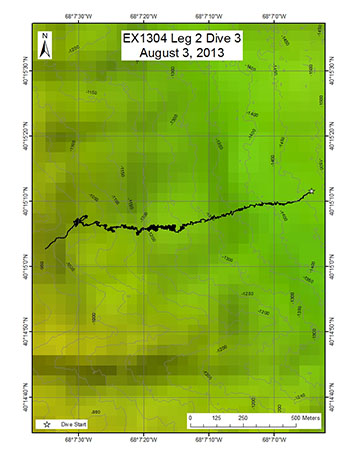
Area
Oceanographer Canyon 1; Northeast U.S. Canyons
Overview
| Date: | August 03, 2013 |
| Max Depth: | 1239.3 Meters |
| Bottom Time: | 6 Hours 34 Minutes 59 Seconds |
Purpose
The purpose of the dive was to: 1. Characterize the submarine canyon geomorphology and benthic habitats, including possible coral and sponge communities at a depth of ~1200 m in Oceanographer Canyon. 2. Groundtruth a model of predicted deep-sea coral occurrence.
Download & View Files
| Dive Summary Report (PDF - 842 KB) | View/Download | Requires Adobe Acrobat Reader to view the Dive Summary Report |
| Dive Track (KML - 169 KB) | View/Download | Requires Google Earth or equivalent client to view the Dive Track |
| ROV Ancillary Data (Zip - 39 MB) | Download | Link takes you to a public FTP server |
| Camera Platform Sensor Data (Zip - 4.28 MB) | Download | Link takes you to a public FTP server |
| Low-Resolution Video Clips (Zip - 3.6 GB) | Download | Link takes you to a public FTP server |
| Underwater Still Images (Zip - 379 MB) | Download | Link takes you to a public FTP server |
| Dive Video Collection Self-Service Portal | Open | Link takes you to an online video discovery and access tool |
Mytilus Seamount North
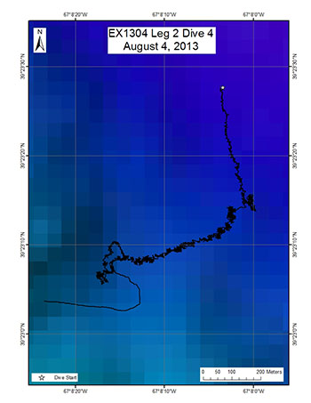
Area
Mytilus Seamount North; Northeast U.S. Canyons
Overview
| Date: | August 04, 2013 |
| Max Depth: | 3271.4 Meters |
| Bottom Time: | 6 Hours 25 Minutes 56 Seconds |
Purpose
Despite a significant level of past effort, the New England seamounts, a major chain of undersea mountains, remains largely unexplored. Building on previous work, we will conduct the first ecological explorations of the New England seamounts. Of those seamounts within the US EEZ, Mytilus Seamount has yet to be visited in this regard. This dive will explore steep terrain along the north side of the seamount to characterize deep sea coral and sponge communities.
Download & View Files
| Dive Summary Report (PDF - 876 KB) | View/Download | Requires Adobe Acrobat Reader to view the Dive Summary Report |
| Dive Track (KML - 102 KB) | View/Download | Requires Google Earth or equivalent client to view the Dive Track |
| ROV Ancillary Data (Zip - 18.6 MB) | Download | Link takes you to a public FTP server |
| Camera Platform Sensor Data (Zip - 5.53 MB) | Download | Link takes you to a public FTP server |
| Low-Resolution Video Clips (Zip - 5.5 GB) | Download | Link takes you to a public FTP server |
| Underwater Still Images (Zip - 510 MB) | Download | Link takes you to a public FTP server |
| Dive Video Collection Self-Service Portal | Open | Link takes you to an online video discovery and access tool |
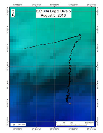
Mytilus Seamount South
Area
Mytilus Seamount South; Northeast U.S. Canyons
Overview
| Date: | August 05, 2013 |
| Max Depth: | 3262.3 Meters |
| Bottom Time: | 7 Hours 4 Minutes 29 Seconds |
Purpose
Despite a significant level of past effort, the New England seamounts, a major chain of undersea mountains, remains largely unexplored. Building on previous work, we will conduct the first ecological explorations of the New England seamounts. Of those seamounts within the US EEZ, Mytilus Seamount has yet to be visited in this regard. This dive will explore steep terrain along the south side of the seamount to characterize deep sea coral and sponge communities.
Download & View Files
| Dive Summary Report (PDF - 769 KB) | View/Download | Requires Adobe Acrobat Reader to view the Dive Summary Report |
| Dive Track (KML - 85 KB) | View/Download | Requires Google Earth or equivalent client to view the Dive Track |
| ROV Ancillary Data (Zip - 30 MB) | Download | Link takes you to a public FTP server |
| Camera Platform Sensor Data (Zip - 5.76 MB) | Download | Link takes you to a public FTP server |
| Low-Resolution Video Clips (Zip - 4.1 GB) | Download | Link takes you to a public FTP server |
| Underwater Still Images (Zip - 456 MB) | Download | Link takes you to a public FTP server |
| Dive Video Collection Self-Service Portal | Open | Link takes you to an online video discovery and access tool |
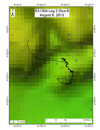
Nygren Canyon Mid Deep
Area
Nygren Canyon Mid Deep; Northeast U.S. Canyons
Overview
| Date: | August 06, 2013 |
| Max Depth: | 1590.4 Meters |
| Bottom Time: | 6 Hours 24 Minutes 57 Seconds |
Purpose
The purpose of the dive was to: 1. Characterize the submarine canyon geomorphology and benthic habitats, including possible coral and sponge communities at a depth of ~1300-1600 m on the southwestern wall of Nygren Canyon. 2. Groundtruth a model of predicted deep-sea coral occurrence.
Download & View Files
| Dive Summary Report (PDF - 882 KB) | View/Download | Requires Adobe Acrobat Reader to view the Dive Summary Report |
| Dive Track (KML - 169 KB) | View/Download | Requires Google Earth or equivalent client to view the Dive Track |
| ROV Ancillary Data (Zip - 36.1 MB) | Download | Link takes you to a public FTP server |
| Camera Platform Sensor Data (Zip - 4.33 MB) | Download | Link takes you to a public FTP server |
| Low-Resolution Video Clips (Zip - 4.3 GB) | Download | Link takes you to a public FTP server |
| Underwater Still Images (Zip - 354 MB) | Download | Link takes you to a public FTP server |
| Dive Video Collection Self-Service Portal | Open | Link takes you to an online video discovery and access tool |
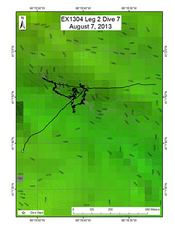
Heezen Canyon Deep
Area
Heezen Canyon Deep; Northeast U.S. Canyons
Overview
| Date: | August 07, 2013 |
| Max Depth: | 1723.4 Meters |
| Bottom Time: | 6 Hours 6 Minutes 39 Seconds |
Purpose
The purpose of the dive was to: 1. Characterize the submarine canyon geomorphology and benthic habitats, including possible coral and sponge communities at a depth of ~1400-1700 m on the southwestern wall of Heezen Canyon. 2. Groundtruth a model of predicted deep-sea coral occurrence.
Download & View Files
| Dive Summary Report (PDF - 844 KB) | View/Download | Requires Adobe Acrobat Reader to view the Dive Summary Report |
| Dive Track (KML - 152 KB) | View/Download | Requires Google Earth or equivalent client to view the Dive Track |
| ROV Ancillary Data (Zip - 24.4 MB) | Download | Link takes you to a public FTP server |
| Camera Platform Sensor Data (Zip - 4.21 MB) | Download | Link takes you to a public FTP server |
| Low-Resolution Video Clips (Zip - 4.1 GB) | Download | Link takes you to a public FTP server |
| Underwater Still Images (Zip - 226 MB) | Download | Link takes you to a public FTP server |
| Dive Video Collection Self-Service Portal | Open | Link takes you to an online video discovery and access tool |
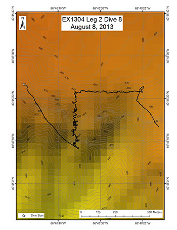
Nygren Canyon Shallow
Area
Nygren Canyon Shallow; Northeast U.S. Canyons
Overview
| Date: | August 08, 2013 |
| Max Depth: | 914.6 Meters |
| Bottom Time: | 7 Hours 18 Minutes 53 Seconds |
Purpose
The purpose of the dive was to: 1. Characterize the submarine canyon geomorphology and benthic habitats, including possible coral and sponge communities at a depth of ~900 m on the northeastern wall of Nygren Canyon. 2. Groundtruth a model of predicted deep-sea coral occurrence.
Download & View Files
| Dive Summary Report (PDF - 896 KB) | View/Download | Requires Adobe Acrobat Reader to view the Dive Summary Report |
| Dive Track (KML - 228 KB) | View/Download | Requires Google Earth or equivalent client to view the Dive Track |
| ROV Ancillary Data (Zip - 34.2 MB) | Download | Link takes you to a public FTP server |
| Camera Platform Sensor Data (Zip - 4.29 MB) | Download | Link takes you to a public FTP server |
| Low-Resolution Video Clips (Zip - 4.4 GB) | Download | Link takes you to a public FTP server |
| Underwater Still Images (Zip - 428 MB) | Download | Link takes you to a public FTP server |
| Dive Video Collection Self-Service Portal | Open | Link takes you to an online video discovery and access tool |
Heezen Canyon Shallow
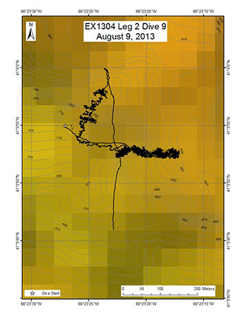
Area
Heezen Canyon Shallow; Northeast U.S. Canyons
Overview
| Date: | August 09, 2013 |
| Max Depth: | 925.9 Meters |
| Bottom Time: | 6 Hours 35 Minutes 42 Seconds |
Purpose
The purpose of the dive was to: 1. Characterize the submarine canyon geomorphology and benthic habitats, including possible coral and sponge communities at a depth of ~1400-1700 m on the southwestern wall of Heezen Canyon. 2. Groundtruth a model of predicted deep-sea coral occurrence.
Download & View Files
| Dive Summary Report (PDF - 1.1 MB) | View/Download | Requires Adobe Acrobat Reader to view the Dive Summary Report |
| Dive Track (KML - 220 KB) | View/Download | Requires Google Earth or equivalent client to view the Dive Track |
| ROV Ancillary Data (Zip - 42.8 MB) | Download | Link takes you to a public FTP server |
| Camera Platform Sensor Data (Zip - 4.42 MB) | Download | Link takes you to a public FTP server |
| Low-Resolution Video Clips (Zip - 4.4 GB) | Download | Link takes you to a public FTP server |
| Underwater Still Images (Zip - 450 MB) | Download | Link takes you to a public FTP server |
| Dive Video Collection Self-Service Portal | Open | Link takes you to an online video discovery and access tool |
Nygren/Heezen Intercanyon
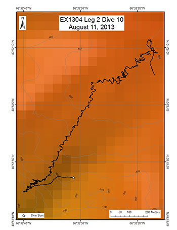
Area
Nygren/Heezen Intercanyon; Northeast U.S. Canyons
Overview
| Date: | August 11, 2013 |
| Max Depth: | 824.3 Meters |
| Bottom Time: | 7 Hours 13 Minutes 26 Seconds |
Purpose
The New England and Mid-Atlantic Fisheries Management Councils are particularly interested in intercanyons to provide more information on depth boundaries for deep-sea coral protection. The purpose of the dive was to: 1. Characterize the submarine canyon geomorphology and benthic habitats, including possible coral and sponge communities. 2. Groundtruth a model of predicted deep-sea coral occurrence.
Download & View Files
| Dive Summary Report (PDF - 874 KB) | View/Download | Requires Adobe Acrobat Reader to view the Dive Summary Report |
| Dive Track (KML - 229 KB) | View/Download | Requires Google Earth or equivalent client to view the Dive Track |
| ROV Ancillary Data (Zip - 30.2 MB) | Download | Link takes you to a public FTP server |
| Camera Platform Sensor Data (Zip - 4.28 MB) | Download | Link takes you to a public FTP server |
| Low-Resolution Video Clips (Zip - 4.5 GB) | Download | Link takes you to a public FTP server |
| Underwater Still Images (Zip - 459 MB) | Download | Link takes you to a public FTP server |
| Dive Video Collection Self-Service Portal | Open | Link takes you to an online video discovery and access tool |
Lydonia/Powell Intercanyon
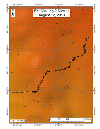
Area
Lydonia/Powell Intercanyon; Northeast U.S. Canyons
Overview
| Date: | August 12, 2013 |
| Max Depth: | 662.8 Meters |
| Bottom Time: | 7 Hours 32 Minutes 7 Seconds |
Purpose
The New England and Mid-Atlantic Fisheries Management Councils are particularly interested in intercanyons to provide more information on depth boundaries for deep-sea coral protection. The purpose of the dive was to: 1. Characterize the submarine canyon geomorphology and benthic habitats, including possible coral and sponge communities. 2. Groundtruth a model of predicted deep-sea coral occurrence.
Download & View Files
| Dive Summary Report (PDF - 807 KB) | View/Download | Requires Adobe Acrobat Reader to view the Dive Summary Report |
| Dive Track (KML - 234 KB) | View/Download | Requires Google Earth or equivalent client to view the Dive Track |
| ROV Ancillary Data (Zip - 38.7 MB) | Download | Link takes you to a public FTP server |
| Camera Platform Sensor Data (Zip - 4.29 MB) | Download | Link takes you to a public FTP server |
| Low-Resolution Video Clips (Zip - 4.7 GB) | Download | Link takes you to a public FTP server |
| Underwater Still Images (Zip - 361 MB) | Download | Link takes you to a public FTP server |
| Dive Video Collection Self-Service Portal | Open | Link takes you to an online video discovery and access tool |
Lydonia Canyon
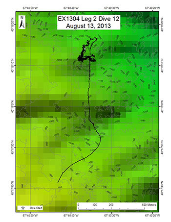
Area
Lydonia Canyon; Northeast U.S. Canyons
Overview
| Date: | August 13, 2013 |
| Max Depth: | 1238.9 Meters |
| Bottom Time: | 6 Hours 23 Minutes 59 Seconds |
Purpose
The purpose of the dive was to: 1. Characterize the submarine canyon geomorphology and benthic habitats, including possible coral and sponge communities. 2. Groundtruth a model of predicted deep-sea coral occurrence.
Download & View Files
| Dive Summary Report (PDF - 935 KB) | View/Download | Requires Adobe Acrobat Reader to view the Dive Summary Report |
| Dive Track (KML - 189 KB) | View/Download | Requires Google Earth or equivalent client to view the Dive Track |
| ROV Ancillary Data (Zip - 42.9 MB) | Download | Link takes you to a public FTP server |
| Camera Platform Sensor Data (Zip - 4.79 MB) | Download | Link takes you to a public FTP server |
| Low-Resolution Video Clips (Zip - 5.4 GB) | Download | Link takes you to a public FTP server |
| Underwater Still Images (Zip - 606 MB) | Download | Link takes you to a public FTP server |
| Dive Video Collection Self-Service Portal | Open | Link takes you to an online video discovery and access tool |
Oceanographer Canyon 2
Area
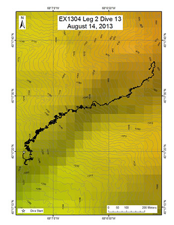
Oceanographer Canyon 2; Northeast U.S. Canyons
Overview
| Date: | August 14, 2013 |
| Max Depth: | 1247.6 Meters |
| Bottom Time: | 6 Hours 44 Minutes 47 Seconds |
Purpose
This dive track is along the approximate location of Alvin dive 1035 from 1980 and 3702 from 2001 and will examine potential changes in the biology and geology of the area over 30+ years. The purpose of the dive was to: 1. Characterize the submarine canyon geomorphology and benthic habitats, including possible coral and sponge communities. 2. Groundtruth a model of predicted deep-sea coral occurrence.
Download & View Files
| Dive Summary Report (PDF - 876 KB) | View/Download | Requires Adobe Acrobat Reader to view the Dive Summary Report |
| Dive Track (KML - 170 KB) | View/Download | Requires Google Earth or equivalent client to view the Dive Track |
| ROV Ancillary Data (Zip - 35.8 MB) | Download | Link takes you to a public FTP server |
| Camera Platform Sensor Data (Zip - 4.48 MB) | Download | Link takes you to a public FTP server |
| Low-Resolution Video Clips (Zip - 4.9 GB) | Download | Link takes you to a public FTP server |
| Underwater Still Images (Zip - 485 MB) | Download | Link takes you to a public FTP server |
| Dive Video Collection Self-Service Portal | Open | Link takes you to an online video discovery and access tool |
Welker Canyon

Area
Welker Canyon; Northeast U.S. Canyons
Overview
| Date: | August 15, 2013 |
| Max Depth: | 1445.4 Meters |
| Bottom Time: | 5 Hours 8 Minutes 35 Seconds |
Purpose
The dive track was chosen based on a combination of regional habitat prediction models for deep sea corals and local identification of high slope features from 20 m multibeam mosaics. Past experience and modeling in this region indicates that deep sea coral habitats are often found in the canyons in areas with slopes > 360.
Download & View Files
| Dive Summary Report (PDF - 836 KB) | View/Download | Requires Adobe Acrobat Reader to view the Dive Summary Report |
| Dive Track (KML - 244 KB) | View/Download | Requires Google Earth or equivalent client to view the Dive Track |
| ROV Ancillary Data (Zip - 925 KB) | Download | Link takes you to a public FTP server |
| Camera Platform Sensor Data (Zip - 5.83 MB) | Download | Link takes you to a public FTP server |
| Low-Resolution Video Clips (Zip - 8.8 GB) | Download | Link takes you to a public FTP server |
| Underwater Still Images (Zip - 492 MB) | Download | Link takes you to a public FTP server |
| Dive Video Collection Self-Service Portal | Open | Link takes you to an online video discovery and access tool |
USGS Hazard 3
Area
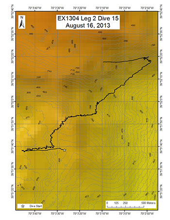
USGS Hazard 3; Northeast U.S. Canyons
Overview
| Date: | August 16, 2013 |
| Max Depth: | 899.3 Meters |
| Bottom Time: | 7 Hours 11 Minutes 57 Seconds |
Purpose
The purpose of this proposed dive is to investigate small, potentially recent, landslide debris deposits and scarps within a larger landslide scar on the upper continental slope. The scientific rationale for this site is to: 1. Determine if these small landslide debris features are relatively young and if they pose a hazard in terms of tsunami generation. 2. Evaluate the long term stability of landslide scars and test hypotheses about their evolution. 3. Attempt to develop a means of using biologic activity on the scarps and deposits as a means of determining relative ages of the features and the response of bottom communities to catastrophic events.
Download & View Files
| Dive Summary Report (PDF - 752 KB) | View/Download | Requires Adobe Acrobat Reader to view the Dive Summary Report |
| Dive Track (KML - 222 KB) | View/Download | Requires Google Earth or equivalent client to view the Dive Track |
| ROV Ancillary Data (Zip - 36.6 MB) | Download | Link takes you to a public FTP server |
| Camera Platform Sensor Data (Zip - 4.29 MB) | Download | Link takes you to a public FTP server |
| Low-Resolution Video Clips (Zip - 5 GB) | Download | Link takes you to a public FTP server |
| Underwater Still Images (Zip - 439 MB) | Download | Link takes you to a public FTP server |
| Dive Video Collection Self-Service Portal | Open | Link takes you to an online video discovery and access tool |

